Author: GPS World Staff

  • Verizon Vehicle Service Designed for Unconnected Cars

    Verizon will soon be offering Verizon Vehicle to U.S. consumers. The new connected-vehicle service aims to modernize traditional roadside assistance offerings while enhancing driver safety, convenience and savings, according to Verizon. Verizon made the announcement today at the North American International Auto Show in Detroit.

    Verizon Vehicle is expected to make its commercial debut in the second quarter of 2015. With Verizon Vehicle, drivers will have easy access to diagnostic technology, live assistance, and roadside assistance with GPS accuracy. The service can connects drivers to live A.S.E. certified mechanics to diagnose potential problems and offer solutions. If drivers need assistance, the built-in GPS identifies their exact location, and a tow truck driver or other help can be dispatched as needed, with precision.

    Erik Goldman, president of Verizon Telematics, explained that more than 200 million U.S. vehicles lack connected capabilities, vehicles that could benefit from the new service.

    “As one of the largest communications companies in the world, we are dedicated to providing consumers with innovative technology solutions that connect people, solve challenges and inspire change,” Goldman said. “Verizon Vehicle is a unique and truly holistic aftermarket solution available to over 200 million vehicles on the road today. It affords millions of drivers the power of knowing when things aren’t working well, potentially before a breakdown occurs — fostering a safer, smarter and more economical way to drive and maintain a vehicle. And while even the best technology can’t prevent every breakdown, the service modernizes the traditional roadside assistance offerings which, for the most part, haven’t been updated in 50 years.”

    Verizon Vehicle is powered by the Verizon Wireless network and is compatible with nearly every vehicle made and sold in the U.S. since 1996 — more than 9,000 makes and models. Verizon Vehicle will launch as a subscription-based service available to drivers regardless of the wireless service provider they use for their mobile devices. Members also receive discounts on travel including hotels and auto services.

    The service operates through an OBD reader that can be self-installed in the under-dash diagnostic port, a Bluetooth-enabled speaker attached to the visor and a smartphone app. Members can choose to use the app or elect to set up the service to contact them — by phone, text, push notification or email — if a potential issue is detected with their vehicle. The speaker offers one-button push connection to the member care group, the mechanics hotline and roadside assistance, as well as a second button for SOS emergency situations.

    The subscription-based service will include:

    • GPS-directed pinpoint Roadside Assistance for breakdowns, flat tires, overheating, a dead battery — anything that might require towing or immediate repair. Dispatches are made to the exact location of a disabled vehicle.
    • Automatic Urgent Incident Alert System places a call to the Verizon Vehicle Member Care Center in the event of a suspected accident. Help is immediately dispatched to the location if an accident is confirmed or there is no response from the driver. The time saved can potentially save lives by delivering critical emergency assistance when a person may not be able to call for help.
    • One-Button SOS Assistance immediately connects the driver to a live agent for emergency aid.
    • Auto Health System with Predictive Diagnostics translates most “check engine” light occurrences into real terms, including the description and severity of the matter, the probable solutions for the problem — and the appropriate cost for the repairs. The system is also designed to provide early warnings relating to some vehicle functions, even before a warning light comes on, to help keep you off the side of the road.
    • Mechanic’s Hotline is staffed with A.S.E. Certified Mechanics providing members access to immediate and unbiased information related to their vehicles, and a professional analysis of trouble they may be experiencing.
    • Parking & Meter Tools help drivers find where they left their vehicle —using the Verizon Vehicle smartphone app — while also keeping track of how much time is left on the meter.
    • Maintenance Alerts inform vehicle owners when scheduled maintenance is required. No more guesswork as to when to rotate those tires or change the oil.
    • Stolen Vehicle Location Assistance guides drivers when reporting a theft and helps authorities recover the stolen vehicle.
    • Travel & Repair Savings — Verizon Vehicle members will be entitled to discounts on hotels, vehicle rentals, auto maintenance, repairs and related travel expenses.

    The service is expected to launch nationally this spring with availability thru nationwide retailers late in 2015. Advance consumer orders for the service are being accepted at VerizonVehicle.com and at 800-711-5800.

  • PNT Board Report: GPS Critical Infrastructure, Concern over International Signals

    Report on the 14th meeting of the National Space-based PNT Advisory Board in Washington, D.C., held December 10-11, 2014.

    By Ron Hatch

    Ron Hatch
    Ron Hatch

    The December meeting of the PNT Advisory Board meeting brought forth important developments and proposals for the protection of GPS as part of the U.S. critical national infrastructure. A separate presentation made by speakers from the National Telecommunications and Information Administration (NTIA) and the Federal Communications Commission (FCC), concerning possible limitations on the use of signals from other GNSS, generated some controversy, alarm, and extensive follow-on discussion by industry, users, and other concerned parties.

    Critical Infrastructure. Perhaps the most important presentation was that of Brad Parkinson, the acting chair, in his recap of the recommendations to be made by the Advisory Board to the PNT EXCOM.

    The first recommendation was a reiteration of the Advisory Board opinion that the GPS be designated as one of the “critical infrastructures” of the United States. This opinion was based upon the fact that 14 of the existing designated critical infrastructures involves the use of GPS. The feeling was that such a designation would enhance the attention focused upon ensuring GPS reliability.

    A second recommendation was that a comprehensive threat assessment to GPS operation be generated that can be used to assess its vulnerabilities. The remaining recommendations to the EXCOM were based upon the results of studies by the two working groups that were presented next.

    The two working groups of the advisory board, specifically the “Assured Availability and the “Economic Value of PNT” working groups, gave the next set of presentations. The Assured Availability working group was split into three sub-groups. The three aspects addressed were to “Protect,” “Toughen,” and “Augment.” The Protect working group recommended action to encourage the reversal of European initiatives to authorize pseudolites that broadcast within the GNSS L1 frequency band. Since such pseudolites would constitute authorized interference to standard GNSS receivers, it was recommended that our State Department encourage a reconsideration of the pseudolite proposals and that they be constrained to operate on a frequency outside the L1 frequency band.

    The Toughen working group looked at a number of measures by which GNSS receivers could be improved to better withstand intentional and unintentional interference. Phased array antennas, inertial aiding and various software tracking improvements were discussed. An invited presentation by Gary McGraw of Rockwell addressed some of these issues particularly from a military perspective. An additional invited presentation upon the requirements for precise time-keeping in trading of financial transactions was presented by Andrew Bach.

    The Augment working group discussed a number of ways in which the GNSS capabilities could be augmented. Prior recommendations that eLoran should be maintained as a backup was again strongly recommended. In addition, the ability to track other GNSS satellites in addition to GPS satellites was encouraged, even though it was recommended that special precautions and automated checks needed to be implemented in the light of the system failures that have been noted with the GLONASS satellites. A very interesting invited presentation by Robert Lutwak of the Defense Advanced Research Projects Agency (DARPA) described the continuing progress toward higher precision inertial sensors.

    The second working group, the Economic Value of PNT, reported on firmed up plans to strengthen the existing studies of the economic value of PNT by engaging the economists resident within the various cabinet departments within the EXCOM to which the Advisory Board reports. The detailed plans were given in a presentation by Irv Leveson that outlined the plans for “A Comprehensive Quantitative Economic Assessment of GPS.”

    It is not my intention to slight any of the other presentations, but I felt two of the remaining presentations were very important. Specifically, the presentation by Karen Van Dyke on Department of Transportation plans regarding “Adjacent L-Band Compatibility and GPS Signal Monitoring” was very encouraging. Among other items, it indicates that adjacent band-power limits will be carefully analyzed and tested to ensure that all existing applications of GPS will not be harmed.

    FCC on International Signal Use. The second presentation that I felt was very important was by Paige Atkins of the National Telecommunications and Information Administration (NTIA) and Ronald Repasi of the Federal Communications Commission (FCC). Their presentation was titled “NTIA/FCC Spectrum Management Perspectives.” The presentation  covered the background and intent of the various authorizing legislation. There were, however, some disturbing comments made.

    Specifically, the item on the slide about National Space Policy that had a major bullet: “Guidance to all departments and agencies – ‘maintain and enchance’ space-based PNT systems. To this end the U.S. shall (among other things)…” There were two sub-bullets.

    The first addressed GPS protection as a critical infrastructure component. The second sub-bullet stated “Foreign PNT services ‘may be used to augment and strengthen the resiliency of GPS.’” The verbal transcript is not yet available, but it seemed to me that Ron Repasi minimized this statement by indicating that resilience was subject to interpretation.

    The real alarm was in his following comments during the question-and-answer discussion, where he indicated that the use of GLONASS within U.S.-based receivers was not authorized and that, therefore, the frequency band they used was not necessarily subject to protection. In addition, it was indicated that three years ago, procedures were developed whereby one could apply for authorization to the use the GLONASS signals. To date, Ron Reposi indicated that no organization had applied for authorization to use GLONASS, and that therefore it was currently illegal to use it.

    Significant discussion was generated by the above, both following the presentation and the next day in a recap. From the discussion, it appears that a March 2011 regulation outlining the requirements for authorization of receiving “Earth stations” is being interpreted by the FCC as requirements for authorization of GLONASS receivers.

    [Editor’s note: The process for securing a waiver of FCC regulations requiring authorization to receive international RNSS satellite signals was identified in an FCC Public Notice released in 2011.  This process is initiated by National RNSS System providers, which have the satellite information needed to secure a waiver.  Members of the GPS Innovation Alliance (GPSIA, www.gpsalliance.org, formerly the U.S. GPS Industry Council) have stated that they remain fully committed to producing  multi-GNSS signal user equipment consistent with U.S. policy, and to working with the FCC and NTIA in considering these requests.]

    In light of the multitude of GLONASS receivers already in use, including a number of U.S. government and agency receivers, the discussion was primarily on what should be done next. The decision taken was not to panic, but to bring the problem to the attention of the various government departments represented on the EXCOM and proceed with some caution.

    The possibility was raised that NASA, in conjunction with the State Department and other interested parties, could seek a blanket authorization to use GLONASS within GPS receivers. This was discussed and presented as a possible way forward. Clearly, the issue is one that will be followed with great interest.

    For all the presentations at the December meeting, see the presentation slides here.

  • SkyTraq Offers Multi-GNSS Receiver Module for Wearables

    SkyTraq Offers Multi-GNSS Receiver Module for Wearables

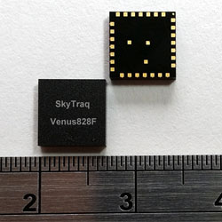
    The SkyTraq Venus828F GNSS receiver module. Photo: SkyTraq Technology
    The SkyTraq Venus828F GNSS receiver module. Photo: SkyTraq Technology

    SkyTraq Technology has introduced a stand-alone multi-GNSS receiver module in a compact 7 x 7 millimeter form factor, the Venus828F, designed with a sensor hub function for wearable and “Internet of Things” (IoT) applications.

    The Venus828F is capable of communication with multiple satellite systems and tracking up to 28 satellites concurrently, SkyTraq said. The compact LGA module integrates all the necessary components for wearables and IoT, forming a complete working GNSS receiver, including GNSS chipset, 0.5ppm TCXO, Flash memory, LDO regulator, DC/DC switching regulator, and passive components. It only requires external antenna and power supply to output accurate position, velocity, and time information in standard NMEA-0183 format, enabling ease of use and fast time to market, Skytraq said.

    The Venus828F features low power consumption, a 29-second cold start TTFF, -165 dBm tracking sensitivity, 10 nsec 1 PPS timing accuracy, on-board geofencing, 8 Mbit – 512 Mbit external SPI Flash data logging, and an industrial operating temperature range of -40C +85C. It has an UART and I2C interface for flexible connection to the host processor.

    Via SPI and I2C connection, data from MEMS sensor can be calculated by Venus828F using sensor-hub-enabled firmware, offloading computation from the host processor. Engineers can concentrate on their wearable and IoT applications instead of spending hundreds of hours reinventing the wheel developing sensor-fusion algorithms, according to SkyTraq.

    “Fast-acquisition high-sensitivity multi-GNSS chipset hardware are just becoming available in recent years, the internal firmware supporting multi-GNSS typically are not as fully optimized as GPS-only firmware that has matured for more than a decade to allow ROM codification with optimal performance for any existing GNSS chipset vendors; the multi-GNSS firmware is still being continuously improved over time,” said Michael Chung, VP of sales and marketing, SkyTraq. “By offering Venus828F multi-GNSS receiver module with Flash memory, it’s shipped with the latest, best-performance firmware. It is also later upgradeable in the field if the customer’s design allows. Targeting very high volume, cost-sensitive wearable and IoT applications, Venus828F is offered at price comparable to crystal-based ROM GPS modules on the market, setting a new benchmark in terms of performance, size, and cost for multi-GNSS receiver modules.”

    An engineering sample, datasheet, and reference design for the Venus828F are available now.

  • GPS Antenna Market Report Takes Global View

    Big Market Research is offering a “2014 Market Research Report on Global GPS Antenna Industry” that discusses the world’s major regional market conditions for antennas, including North American, Europe and Asia, and the countries Germany, Japan, China, and the United States, among others.

    The report introduces basic GPS antenna information, including antenna definition classifications and applications, and an industry-chain overview; GPS antenna industry policy and plans; GPS antenna product specification; and the manufacturing process and cost structures. Then the analysts look at regional market conditions, including product price, profit, capacity, production, capacity utilization, supply, demand and industry growth rate.

    The report introduces a GPS antenna new project SWOT analysis, investment feasibility analysis, investment return analysis, and the global GPS antenna industry.

    The report has six parts:

    1. basic product information;
    2. an analysis of the Asian GPS antenna industry;
    3. an analysis of  the North American GPS antenna industry;
    4. an analysis of the European GPS antenna industry;
    5. an analysis of the entry-level market and investment feasibility;
    6. report conclusion.
  • Severe Weather Study Shows Potential of GNSS-RO Satellites

    Severe Weather Study Shows Potential of GNSS-RO Satellites

    Constellation Roll-Out to Begin This Year

    GeoOptics, a satellite-based environmental data services company, in cooperation with Atmospheric and Environmental Research (AER), an environmental research and development company, has announced the initial results of an Observing System Simulation Experiment (OSSE) showing the reliability of radio occultation data in improving predictions of severe weather and flash flood events.

    Using weather prediction models and data assimilation techniques, AER evaluated the potential benefit of observing Earth’s atmosphere with a vast future constellation of many hundreds of orbiting GNSS – Radio Occultation (GNSS-RO) receivers. As a case study, the model used the convective system that brought severe weather to Oklahoma in 2013, which included an Enhanced Fujita Scale-3 tornado and heavy rains.

    “The improved characterization of moisture in the lowest 4-5 km of the atmosphere is very significant and, working with our colleagues at AER, we believe quite a rigorous scientific conclusion,” said Conrad Lautenbacher, GeoOptics CEO. “We see commercial provision of GNSS-RO as a valuable complement to public sector systems and a reliable, low-cost way to achieve the levels of scale tested. We are very excited by the results.”

    Through collaboration begun in 2014, the two companies set out to assess the impact of vastly increased numbers of GNSS-RO profiles on regional weather forecasting within the context of a global weather satellite system. Oklahoma was the region of focus of the study, an area with a history of severe weather phenomena. Today’s total global GNSS-RO profiles number approximately 1,800 per day, of which 0.64 profiles per day are readings taken over Oklahoma.

    In the study, AER and GeoOptics modeled from 50,000 to 2,000,000 global profiles per day through the deployment of the planned CICERO satellite constellation. Such large scale would correspondingly increase the profiles per day over Oklahoma to between 17 and 700.

    GPS World discussed the use of GPS for radio occultation in its March 1994 Innovation column, “Monitoring the Earth’s Atmosphere with GPS,” by Rob Kursinski.

    “We see commercial remote sensing and particularly the GNSS-RO technology as a paradigm change in developing and maintaining a cost-effective, next-generation operational observational infrastructure for environmental prediction,” said AER President Ron Isaacs. “The superb GNSS-RO technology knowledge base at GeoOptics provides an ideal and exciting complement to AER’s decades-long experience in today’s operational remote sensing and weather prediction practices, which include the current use of GNSS-RO sensing.”

    GNSS-RO profiles provide measurements of atmospheric temperature, moisture, and pressure with a precision unrivaled by other space-based techniques. The RO sensor gathers this information by precisely observing perturbations imposed on ubiquitous GPS radio signals as they pass through the atmosphere. Today, nearly 3,000 organizations in more than 80 countries use RO data in Numerical Weather Prediction (NWP) and research. NOAA’s own studies show that more accurate mid- to long-term forecasts can be made up to 15 hours sooner using the data collected from the current limited set of experimental GPS-RO sensors.

    GeoOptics plans to launch an array of powerful GNSS-RO sensors on its CICERO constellation of low-Earth-orbiting satellites. The rollout of the constellation will begin in the third quarter of 2015 and will deliver more than 50,000 global profiles per day when fully deployed. As demand grows, the 24-satellite CICERO constellation will be expanded to carry additional and complementary instruments, such as scatterometry and gravity sensors.

    “GeoOptics will advance a small satellite observing model that starts with GPS radio occultation,” Lautenbacher added. “We believe an integrated private company like ours can deploy such systems for a fraction of current costs to the government.”

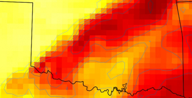
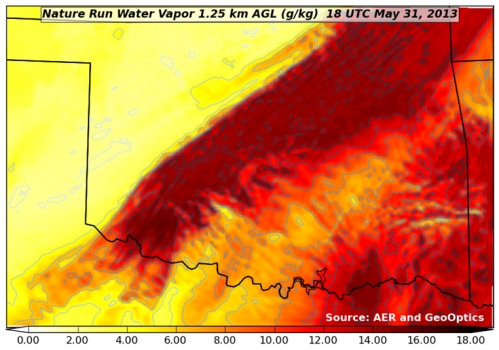
    Figure 1. "Nature Run" atmospheric water vapor at about 4,000 feet above the ground.  The yellow-to-red color scale (bottom of figure) indicates how much water vapor is present, i.e., yellow is dry and red is moist.  This realization of atmosphere moisture during an Oklahoma severe weather outbreak in May 2013 is the yardstick against which our assimilation experiments are compared for realism.  It has a horizontal resolving power of about 1 1/4 mile (i.e., 2 km).
    Figure 1. “Nature Run” (the truth reference) atmospheric water vapor at about 4,000 feet above the ground. The yellow-to-red color scale (bottom of figure) indicates how much water vapor is present, i.e., yellow is dry and red is moist. This realization of atmosphere moisture during an Oklahoma severe weather outbreak in May 2013 is the yardstick against which our assimilation experiments are compared for realism. It has a horizontal resolving power of about 1 1/4 mile (i.e., 2 km).
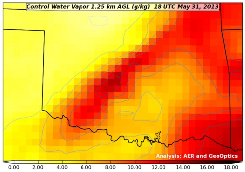
    Figure 2. Atmospheric water vapor analysis using conventional observing system.  Valid time, vertical level and color scale are the same as in Figure 1.  Note that the data fusion experiments use a bigger grid than the Nature Run (Figure 1) with a horizontal resolving power of about 11 miles (i.e., 18 km).
    Figure 2. Atmospheric water vapor analysis using conventional observing system. Valid time, vertical level and color scale are the same as in Figure 1. Note that the data fusion experiments use a bigger grid than the Nature Run (Figure 1) with a horizontal resolving power of about 11 miles (i.e., 18 km).
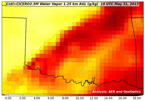
    Figure 3. Atmospheric water vapor analysis using conventional observing system + CICERO radio occultation observations.  The distribution of water vapor in this analysis is much closer to the Nature Run (Fig. 1) in pattern and magnitude than the Control result (Fig. 2).
    Figure 3. Atmospheric water vapor analysis using conventional observing system + CICERO radio occultation observations. The distribution of water vapor in this analysis is much closer to the Nature Run (Fig. 1) in pattern and magnitude than the Control result (Fig. 2).


  • Subscribers: Easy Steps to Access the GPS World Digital Edition

    We’ve changed the way subscribers can access the digital edition of our monthly GPS World magazine.

    Digital subscribers can access the digital edition by an email notification that will appear in their inbox. Just click on the link provided. Accessing the digital edition this way is easy — you won’t need to enter your subscriber number.

    However, if you need to know your subscriber number, you can access it from the email notification.

    Print subscribers can also access the digital version of the magazine by entering their subscriber number when prompted. Your subscriber number can be found on the label of the printed magazine or within the digital email notification. See sample image below.

    Subscribe-notice-W
    Photo: GPS World

    When accessing the digital edition from the website, a newsletter, or the iTunes or Google Play store, you may need to enter your nine-digit subscriber number. Any subscriber may access the content as long as he or she subscribes to the monthly magazine — either the print or digital format.

    If you are not yet a subscriber to the monthly magazine, signing up is easy and, in most instances, free for anyone working in the GPS/GNSS industry. Simply complete the online subscription form.

    The first few pages of each monthly digital edition is available as a preview. When the maximum number of views is reached, the reader will receive a prompt to enter the subscriber number.

    If you have any difficulties, please contact Antoinette Sanchez-Perkins.

  • Block II GPS Satellite Retires after 22 Years

    Jan. 6 was the last day of service for GPS satellite SVN-26. SVN-26 was a Boeing/Rockwell International Block II GPS satellite launched July 7, 1992. It was one of the first generation of operational GPS satellites, and had a design life of only 7.5 years. On Jan. 7, SVN-26 (PRN-26) was transferred from the operational ground control system (AEP) to Launch, Anomaly and Disposal Operations (LADO).

    CGSIC Executive Secretariat Rick Hamilton, USCG Navigation Center, remarked on its longevity. “A testament to the satellite engineers and the men and women of the Air Force, the Second Space Operations Squadron at Schriever Air Force Base has successfully managed SVN-26 in its mission for over 22 years.”

    In the near term, PRN-26 will be used for clock checkout activities on a few LADO satellites. The compatibility test for SVN-71, the next IIF satellite to launch (SVN-71/IIF-9), is scheduled for the week of Jan. 19. PRN-26 will be used by SVN-71 for the compatibility test, and then be used again for LADO satellite clock tests.

    PRN-26 will be reassigned to SVN-71 just before launch from Cape Canaveral on March 25.

  • Glowing Orbs Reveal Presence of GPS


    Designer Timo Arnall has created lamps that change brightness depending on the strength of received GPS signals. The glowing orbs were made with Einar Sneve Martinussen and Jørn Knutsen as part of a research project at the Oslo School of Architecture and Design. The research began in 2009 with RFID and Wi-Fi projects that aim to reveal technology in a visual way.

    “GPS is widely used, yet it’s invisible and few of us really have any idea of how it works or how it inhabits our everyday environments. We wanted to explore the cultural and material realities of GPS technology, and to develop new understandings about it through design,” Arnall said on his website.

    Dubbed “Satellite Lamps,” each orb is embedded with a GPS receiver. As the strength of signal wavers in and out, the glowing orbs become brighter or dimmer. The stronger the signal, the brighter the lamp.

    “Satellite Lamps shows that GPS is not a seamless blanket of efficient positioning technology; it is a negotiation between radio waves, earth-orbit geometry and the urban environment. GPS is a truly impressive technology, but it also has inherent seams and edges,” Arnall said.

    Arnall created a timelapse video showing the lamps in action. “When we photograph them as timelapse films, we start to build a picture of how these signals behave in actual urban spaces,” he said.

    The lamps are part of  project to visualize GPS. Read more about how the lamps were created in the research team’s article. Arnell also wrote about the popular cultural history of GPS.


  • Border Patrol via Drones Not Effective, IG Says

    Border Patrol via Drones Not Effective, IG Says

    The CBP's unmanned aerial program includes the Predator B aircraft, as well as ground control stations, pilots, sensor operators, video cameras, land and maritime radar, and communication equipment. (CBP Photo)
    The CBP’s unmanned aerial program includes the Predator B aircraft, as well as ground control stations, pilots, sensor operators, video cameras, land and maritime radar, and communication equipment. (CBP Photo)

    A new report by the Department of Homeland Security’s Inspector General’s office finds that use of unmanned aerial drones to patrol the U.S./Mexico border is not effective. The Customs and Border Protection’s (CBP) Unmanned Aircraft System program has been in operation for eight years.

    Problems include a lack of performance measures and sky-high operational costs, according to the report, which was issued January 6. “Specifically, the unmanned aircraft are not meeting flight hour goals, and we found little or no evidence CBP has met its program expectations,” the report said. “We estimate it costs $12,255 per flight hour to operate the program; CBP’s calculation of $2,468 per flight hour does not include all operating costs.”

    The $443 million CBP plans to spend on program expansion could be put to better use by using alternative technologies, the IG concluded.

    Read the full report below.

    OIG_15-17_Dec14.pdf

  • Russian Government Sets Up GLONASS Company

    The Russian government is establishing a joint stock company named “GLONASS” with 100-percent participation of the state, according to the website of the Russian Cabinet, as reported by Ria Novosti.

    Russian President Vladimir Putin in July 2014 ordered the government to develop and adopt a roadmap for the creation of an open joint-stock company “GLONASS” with 100-percent state participation. According to the plan, the property complex of the state automated information system “ERA-GLONASS” will be transferred to the share capital of the newly created company. ERA stands for Emergency Response in case of Accidents. “To establish a joint-stock company ‘GLONASS’, 100 percent of the shares of which are federal property… Set the size of the share capital of the company is 100 million rubles,” said the executive order.

    Deputy Prime Minister Dmitry Rogozin in September welcomed the establishment of the company, calling it a first step in the commercialization of space-based services.

    The authorities intend to develop the GLONASS infrastructure to enhance the quality and quantity of services. A development strategy for the new company is due March 30.

  • GPS Director Cooley Nominated for Brigadier General

    Col. William Cooley, Director, U.S.A.F. Global Positioning Systems Directorate.
    Col. William Cooley, Director, U.S.A.F. Global Positioning Systems Directorate.

    Colonel William Cooley, director of the Global Positioning Systems Directorate, has been nominated by President Obama to the Senate for appointment to the rank of brigadier general, United States Air Force, according to an announcement by Secretary of Defense Chuck Hagel. He is the first SPO director in many years to be nominated for general officer rank, according to Don Jewell, GPS World’s contributing editor for defense.

    Cooley is currently serving as senior materiel leader and director, Global Positioning Systems Directorate, Air Force Space Command, Los Angeles Air Force Base, California.

    “This is a great accomplishment for Bill and for the GPS community,” Jewell said. “We are all certainly very proud of him and his accomplishments and his unflagging support for the PNT community globally.”

    “This nomination is an outstanding achievement as it clearly demonstrates continued senior leadership confidence in his ability to lead the men and women in our Air Force. We have been privileged to see that for ourselves here at SMC,” said Samuel A. Greaves, Lieutenant General, USAF, Commander, Space and Missile System Center.

    Col. Cooley authored GPS World’s Directions 2015 article on the outlook for GPS in our December issue, “What It Takes to Make a Gold Standard.”

  • Ford Autonomous Vehicle On the Way, CEO Says

    Ford Autonomous Vehicle On the Way, CEO Says

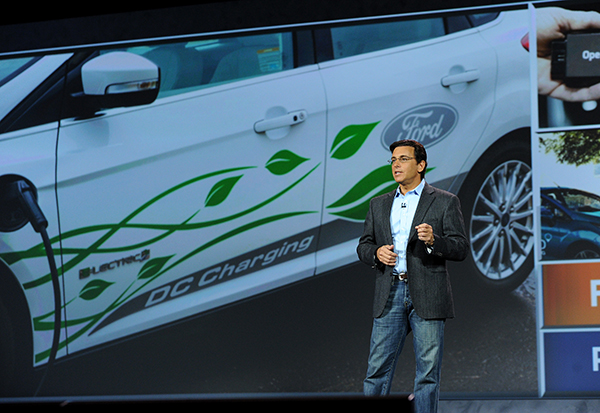
     Mark Fields, President and CEO, Ford Motor Company, delivers the opening keynote address at the 2015 International CES. (Photo by: Sam VarnHagen/Ford)
    Mark Fields, President and CEO, Ford Motor Company, delivers the opening keynote address at the 2015 International CES. (Photo by: Sam VarnHagen/Ford)

    Ford Motor Company highlighted the semi-autonomous vehicles it has on the road today and fully autonomous vehicles now in development at the 2015 Consumer Electronics Show in Las Vegas this week.

    “We’re already manufacturing and selling semi-autonomous vehicles that use software and sensors to steer into both parallel and perpendicular parking spaces, adjust speed based on traffic flow or apply the brakes in an emergency,” said Raj Nair, Ford chief technical officer and group vice president, Global Product Development. “There will be a Ford autonomous vehicle in the future, and we take putting one on the road very seriously.”

    Ford’s semi-autonomous vehicle features available today include lane-keeping assist, adaptive cruise control, Pre-Collision Assist with Pedestrian Detection and active park assist — with Traffic Jam Assist coming.

    A fully autonomous Ford Fusion Hybrid research vehicle is undergoing road testing. The vehicle uses the same semi-autonomous technology in Ford vehicles today, while adding four LiDAR sensors to generate a real-time 3D map of the surrounding environment.

    The vehicle can sense objects around it using the LiDAR sensors, and uses advanced algorithms to help it learn to predict where vehicles and pedestrians might move.

    “Our priority is not in making marketing claims or being in a race for the first autonomous car on the road,” Fields said. “Our priority is in making the first Ford autonomous vehicle accessible to the masses and truly enhancing customers’ lives.”

    Ford Smart Mobility

    The automaker also laid out its Ford Smart Mobility plan for connectivity, mobility, autonomous vehicles, the customer experience and big data. Included are 25 experiments set for this year — eight in North America, nine in Europe and Africa, seven in Asia and one in South America.

    Each experiment is designed to anticipate what customers will want and need in tomorrow’s transportation ecosystem. “We see a world where vehicles talk to one another, drivers and vehicles communicate with the city infrastructure to relieve congestion, and people routinely share vehicles or multiple forms of transportation for their daily commute,”said Ford President and CEO Mark Fields.  “The experiments we’re undertaking today will lead to an all-new model of transportation and mobility within the next 10 years and beyond.”

    The 25 experiments address four global megatrends — explosive population growth, an expanding middle class, air quality and public health concerns, and changing customer attitudes and priorities — challenging today’s transportation model and limiting personal mobility, especially in urban areas.

    Fourteen of the 25 experiments are Ford-led research projects, and 11 are part of the company’s Innovate Mobility Challenge Series. The experiments include:

    With the Innovate Mobility Challenge Series, Ford invited innovators and developers around the world to create solutions for specific mobility challenges in North America and South America, Portugal, Africa, India, China, England and Australia. Challenges included finding technology solutions to identify open parking spaces in urban areas, better ways to navigate crowded cities and the use of navigation and other tools to help people gain access to medical care in remote areas.

    SYNC 3

    Also at CES, Ford is demonstrating SYNC 3, the company’s new communications and entertainment system that is faster, more intuitive and easier to use with enhanced response to driver commands. SYNC 3 has more conversational speech recognition technology, a more smartphone-like touch screen and easy-to-read graphics to help drivers connect and control their smartphone while on the road.

    The next-generation system builds on the capability of SYNC technology already in more than 10 million vehicles on the road globally. SYNC 3 begins arriving on new vehicles this year.

    “Ford is delivering an easier way for customers to stay connected,” said Nair. “SYNC 3 is another step forward in delivering connectivity features customers most want, and they tell us this kind of technology is an important part of their decision to buy our vehicles.”

    “Even as we showcase connected cars and share our plans for autonomous vehicles, we are here at CES with a higher purpose,” Fields said. “We are driving innovation in every part of our business to be both a product and mobility company — and, ultimately, to change the way the world moves just as our founder Henry Ford did 111 years ago.”