A new night map integration feature is available for all Concept3D maps. The toggle-on map overlay is designed to enhance campus safety and security by making it easy to find the best, well-lit routes and critical resources such as emergency phones.
The Concept3D interactive mapping platform is used by hundreds of major universities, colleges and schools, as well as convention centers, hospitals, resorts, retirement communities, data centers and businesses.
The night map feature offers all of these clients a way to provide their audiences with important safety and security information for visiting and navigating the campus at night.
The University of Denver, Boise State University, and Pacific Lutheran University are the first to integrate this feature into their Concept3D-powered interactive campus maps.
The night map of the campus of Boise State University. (Image: Concept3D)
Boise State University is using the new night map feature to highlight Public Safety Dispatch Centers, Emergency Blue Light and Refugee Phones and locations of automated external defibrillators (AEDs). Each item has a display box that further explain the exact location of the service and additional information.
Pacific Lutheran uses the night map to display campus AEDs, emergency telephones, and its safety building.
Colleges and universities that participate in federal Title IV student financial assistance programs must comply with the Clery Act, which requires annual security reporting, details and geographic information about crimes committed on campus and on public areas immediately adjacent to the campus, and timely warnings and emergency notifications, among other requirements.
Airbus has enlarged its high-resolution imagery portfolio following an agreement to leverage capacity from the S1-4 satellite built by Surrey Satellite Technology Limited (SSTL). The new imagery offer — called Vision-1 — delivers end-to-end imaging operations to Airbus’ customers.
Vision-1 provides 0.9-meter resolution imagery in the panchromatic band and 3.5-meter in the multispectral bands (NIR, RGB), with a 20.8-kilometer swath width. These specifications are ideal for defence, security and agriculture applications, while this extra revisit opportunity further strengthens Airbus’ satellite fleet.
“This new asset will reinforce our monitoring capabilities for sub-metre imaging, and feed our OneAtlas digital platform to provide increased freshness,” said François Lombard, director of Intelligence Business at Airbus Defence and Space.
Vision-1 operations will be coordinated by Airbus in the UK, following integration into the UK Mission Operation Centre, which operates the commercial imaging of the DMC Constellation. This is an important step for UK sovereign imaging capability, Airbus said, adding sub-meter data to the existing UK imaging capabilities.
As Vision-1 was launched in September 2018 together with NovaSAR, this opens significant opportunities for applications combining optical and radar satellite imagery.
Along with Vision-1, Airbus offers commercial access to the largest fleet of Earth Observation satellites: Pléiades, SPOT 6/7, DMC Constellation and the weather-independent radar satellites TerraSAR-X, TanDEM-X and PAZ.
The National Geographic Society, working with partners at Google and World Resources Institute, is building a living map of the world.
National Geographic is calling on the community of land cover and photo interpretation experts by September to help annotate and curate Sentinel-2 satellite imagery needed by machine learning algorithms. Experts who can spend 20-40 hours on this task in the next 6-8 weeks should send their resumes to [email protected].
“Our vision is to produce the world’s first open global time series map of land cover and land use at 10-meter resolution with annual updates using public satellite imagery,” the society said in a statement.
A living map of the world is a foundational dataset for knowledge products driving understanding and forecasting of the world as a system and enabling data-driven conservation, resource management and policy making for sustainable development.
Simultaneous advances in global satellite imagery, super-computing on demand in commercial cloud, and powerful open source machine learning algorithms in high-performance software frameworks, combine to enable production of a global time series map of land cover and land use at a scale, speed and cost that is within reach for large NGOs and global governments.
The major roadblock to production of a global time series map is availability of a large quantity of high-quality annotated data (hundreds of millions of labeled pixels) required to train algorithms to automate production of the map time series.
National Geographic is aiming to create an initial training dataset of densely annotated tiles of Sentinel-2 imagery before September, following an expert-defined land cover taxonomy. This expert-labeled tile set will be used to train a large non-expert crowd to produce tens of thousands of additional labeled scenes, which will then be used to train the machine learning algorithms that produce maps.
Galileo is on the march with a new generation of satellites bearing improved atomic clocks. The first of the Batch 3 navigation payloads was delivered in June by Surrey Satellite Technology (SSTL) in the UK to OHB System AG in Bremen, Germany.
SSTL’s payload for Batch 3 is a recurrent build of the existing FOC payload, with an evolution of the atomic clocks to incorporate advances made under the European GNSS Evolution Programme. The earlier SSTL Galileo FOC payload comprised different units including European-sourced atomic clocks, navigation signal generators, high power traveling wave tube amplifiers and antennas.
The new payload will be integrated aboard the satellite platform Galileo FOC FM23, named Patrick in honor of the winner of a drawing competition. Payload integration will be followed by a series of comprehensive test activities. Patrick and its next youngest sibling satellite of this series are scheduled to be ready for launch in autumn 2020.
“We are looking forward to this first ‘marriage’ of a Batch-3-payload and platform and are ready to start Patrick’s test sequence soon,” said Lars Peters from OHB System AG, in charge of the Assembly Integration and Test for the satellites at eleven production islands where one satellite is completed every five weeks.
“The ambitious schedule means that looking forward reserve satellites will be available both in orbit and on the ground,” added Dr. Wolfgang Paetsch, a member of the OHB System AG Management Board responsible for navigation, Earth observation and science.
“Of course we are waiting a bit to see what the real lifetime of the satellites is going to be. We don’t know that yet but we will find out in the next couple of years. Obviously there is a lot of pressure for further innovation, for further improvements. The user community over the last couple of years has become more outspoken about what they want and what they expect, which is nice. Obviously we need to take care of the legacy users, and we are having to see what new technology would allow us to do.”
OHB System AG has contracted to deliver a further twelve satellites of this Batch 3 for Galileo. This will bring to 34 the number of Galileo satellites being supplied by the SSTL-OHB partnership. Of these, 14 are already in orbit.
Feature photo: The satellite Patrick, first of Galileo’s Batch 3, will eventually travel from OHB to ESA’s ESTEC technical centre (shown here) in Noordwijk, the Netherlands for rigorous testing in simulated space conditions. (Photo: European Space Agency)
All newly-built commercial aircraft must adhere to safety standards that go into effect Jan. 1, 2021. Orolia, which develops new technology for the Global Aeronautical Distress Safety System (GADSS), offers the Kannad Ultima-DT Distress Tracking Emergency Locator Transmitter.
It features a trigger-in-flight capability to detect imminent emergency situations and send a secure distress signal, including the aircraft’s position, to continuously track its location in any circumstances. The transmitter also includes Return Link Command Service to activate a distress signal from the ground in case of uncertainty about the aircraft’s status, or if attempts to communicate with the flight crew are unsuccessful.
Small towns and cities face tight budgets for operating and maintaining public utilities. By sharing resources for common activities, a city can improve cost efficiency in its gas, electric, water and sewer services. In southern Minnesota, the city of New Ulm has modernized its approach to utility asset location and identification management. The effort is reducing costs and improving service for its 13,000 residents.
For more than a decade, the New Ulm Public Utilities group used a computer-aided design (CAD)-based system to track assets for six different utilities. After evaluating its approach for asset mapping, the city transitioned to a geospatial information system (GIS) which provided an opportunity to streamline data collection and management across all of the city-owned utilities.
The city turned to the Trimble Positions Desktop add-in software for Esri ArcGIS Desktop. The approach enables New Ulm field technicians to use Trimble TerraSync field software and Trimble Geo 7X GNSS handhelds for data collection for utility assets and then process the GNSS data in Trimble Positions Desktop. Using this method, the city can provide customized field workflows needed by the different utilities while delivering completed information to a single, centralized GIS database.
In addition to recording the locations and attributes of utility assets, the Trimble solution helps New Ulm technicians return to specific assets when needed. Using real-time GNSS positioning, field crews can navigate directly to specific assets. “Looking for a shutoff valve during a snowstorm isn’t easy,” said New Ulm GIS technician John Bendix. “The Trimble handhelds help them find an asset quickly.”
Bendix uses the Trimble solution to manage connectivity and geographic relationships for new assets. Assets connected to a feature (such as pipes connecting to a manhole) can be automatically adjusted as needed when new field data is checked into the database.
An electric cooperative that serves more than 33,000 member customers in Lakeside, Arizona — including the White Mountain Apache Tribe — is using an unmanned aerial system (UAS) to enhance the utility’s GIS effort, working with UAS specialist Skynetwest. Noah Ruiz started Skynetwest in 2015 to provide aerial photographic and videographic services, but seeing the potential of UAS he began making the pivot to high-value data retrieval.
Initial work for the Navopache Electric Cooperative (NEC) included an inspection of an area’s substations. Conducted on a day in which the winds were blowing at 20+ mph, with most other aircraft, the flight would have been extremely risky if not scrapped.
Skynetwest used an Intel Falcon 8+ Drone, Topcon Edition. Windspeed limits for the Falcon 8+ in GPS mode are set at 26 mph; in height mode that threshold is extended to windspeeds as high as 35 mph.
The Falcon 8+ has triple-redundancy inertial measurement units (IMUs), double-redundant compasses, dual-constellation GPS, eight propellers and two batteries. Built into the aircraft’s software is an algorithm that detects the electromagnetic frequencies coming off of power lines and tells the IMUs which one it wants to switch from, which GPS it wants to use, and which compass it wants to use.
The aircraft’s stability is key not only for power line work but also for items like inspection of oil and gas components. For inspection applications — close-up inspections to detect millimeter-sized damage, fine hairline cracks, leaks or heat power losses, for example — the Falcon 8+ payload consists of a Panasonic Lumix DMC-ZS50 camera for true-color RGB images and the FLIRTau 2 640 thermal imaging camera for infrared imaging. The hybrid RGB + 14-Bit RAW data inspection payload combines a near-infrared camera with a high-resolution digital camera mounted in parallel.
The mapping package Skynetwest uses includes a 36-megapixel RGB camera (Sony Alpha 7R) and delivers both orthophotos and 3D models in Topcon ContextCapture software, powered by Bentley Systems.
Upon completion of the substation project, using ContextCapture and Agisoft PhotoScan software, Skynetwest stitched together all of the images it had gathered to create a georeferenced 3D model of that substation. NEC is looking into building more 3D representations of the entire grid and ultimately hoping to build a complete 3D spatial record down to nuts and bolts — all with survey grade data.
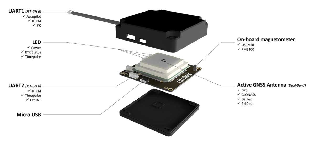
Drotek Electronics is now offering the F9P Sirius RTK GNSS Rover, which is designed to be mounted on a moving vehicle. The u-blox ZED-F9P module inside provides 1-cm position accuracy, a convergence time under 10 seconds and a navigation update rate up to 20 Hz.
The new Sirius RTK GNSS Rover F9P has a built-in active antenna patch. It receives GPS, Galileo, Beidou and GLONASS signals, providing additional accuracy. The F9 Sirius Rover is designed to fit most setup designs as well as integrate easily into a vehicle. Its six-pin JST-GH connector makes it plug-and-play with the Pixhawk Pro 3 autopilot.
Skylark is now available across the contiguous United States, enabling safe and lane-level accurate positioning.
Swift Navigation’s network-connected Skylark precise positioning service is now available throughout the United States. Full contiguous U.S. (CONUS) coverage reduces initialization times to seconds, ensuring high-accuracy, high-integrity positioning is available when customers need it.
Swift Navigation is a San Francisco-based tech firm providing centimeter-accurate GNSS positioning technology for autonomous vehicles, and the maker of the Piksi Multi and Duro GNSS receivers.
Skylark is built for autonomy at scale and delivers lane-level precision, with safety-of-life integrity, required by mass-market automotive and autonomous applications. Skylark is a scalable network delivering a continuous stream via the cloud of robust, reliable, multi-constellation, multi-frequency corrections, with the latency, security, precision and reliability required for safety and autonomy.
“Since Skylark was introduced last year, the Swift network team has been hard at work deploying infrastructure across the country,” said Rob Hranac, COO of Swift Navigation. “This extensive network helps remove hurdles in precise positioning for our customers and we look forward to partnering with those customers as we expand Skylark internationally.”
Skylark is designed to address the needs of automotive original equipment manufacturers (OEMs) by supporting ASIL-rated (Automotive Safety Integrity Level) systems and Ntrip2 (Networked Transport of RTCM via Internet Protocol) connections in cloud reference station (CRS) mode. It is state space representation (SSR) ready — an emerging industry format.
Skylark is hardware-independent, giving customers a choice in today’s rapidly improving and commodifying the GNSS sensor ecosystem. OEMs are able to benefit from the lane-level positioning Skylark delivers using a host of third-party receivers in addition to Swift’s Piksi Multi and Duro receivers.
Unlike legacy real-time-kinematic (RTK) services designed for smaller regions and precise point positioning (PPP) services that suffer from slow convergence times, Skylark is a high-performance hybrid nationwide U.S. network that delivers initialization times in seconds, better than 10 centimeters of accuracy and integrity required by the most demanding safety-of-life critical applications.
When used with Swift’s Starling positioning engine, Skylark is capable of delivering protection levels (PL) down to 1 meter and target integrity risk (TIR) down to 10-7/hour. Engineered for automotive functional safety standard ISO 26262 (ASIL B), Skylark is designed and built from the ground up to support next-generation GNSS applications, connected car, V2X and advanced driver assistance systems (ADAS).
Skylark packages GNSS precise positioning as an affordable subscription service for ease in deployment for large-scale autonomous vehicle fleets.
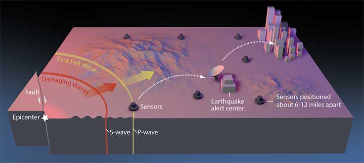
Previous research suggests that not until halfway through a rupture (90 seconds for a magnitude-9 quake) can magnitude be predicted. Geodetic GNSS data could bring this down to as little as 10 seconds — greatly extending and enhancing earthquake early warning systems.
How soon can we predict the magnitude of an earthquake?
Seismologists Diego Melgar of the University of Oregon and Gavin Hayes of the U.S. Geological Survey (USGS) in Golden, Colorado, tackled this question by chance while Melgar was writing code to simulate earthquakes to check the accuracy of Earthquake Early Warning systems in the Pacific Northwest.
He reached out to Hayes, who curates a database for the USGS that contains “source time functions,” which show how the seismic energy release changes through time as the earthquake ruptures.
As a rupture grows, the speed of growth changes, and source time function captures that change. Melgar and Hayes focused on the acceleration of the energy release in large (M>7) and great (M≥9) earthquakes, and found that acceleration wobbled between 2 and 5 seconds after the quakes began.
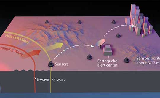
In February 2016, the USGS rolled out the second-generation ShakeAlert Earthquake Early Warning test system in California. The diagram shows how the system would operate. (Image: USGS)
However, with the approximately 250 M≥7 earthquakes in their database, they found that between 10 and 15 seconds after rupture began, these larger earthquakes started to behave similarly, and that behavior scales with their final magnitude, Hayes said. “In other words, the acceleration at 10 to 15 seconds is diagnostic of their final magnitude.”
Earthquake ruptures sputter along for about 10 seconds, after which the big ones accelerate, according to Melgar and Hayes. Three different source time function databases showed the same consistency.
Vertical movement near the source of large earthquakes can be between 3 and 5 meters, according to data from GNSS geodetic receivers. Analysis of near-source GNSS data from 12 M≥7 earthquakes showed that for the first 10 seconds after the first indication of an earthquake was recorded, the earthquakes made almost immeasurable movements. But between 10 and 15 seconds, the amount of vertical displacement began to rapidly diverge for the different magnitude groupings. By 20 to 25 seconds, the vertical movement was distinct.
Previous research indicated roughly half the source duration must pass before an accurate prediction could be made. Cutting the prediction time down to 15 seconds would be invaluable to earthquake early warning systems and tsunami prediction algorithms, where every second counts.
GNSS sensors are installed onshore across the globe, but the majority of megathrust earthquakes occur underwater. To integrate Melgar and Hayes’ findings effectively into earthquake early warning systems would require sensors installed along the seafloor, they noted. “You [would also] need to have fiber-optic cables from shore to the bottom of the ocean, winding around with sensors, and then eventually coming back on shore, and that’s not cheap,” Melgar said.
An additional 10 to 30 seconds of warning to a city or nuclear reactor of an imminent quake would have enormous benefits. But if the hypothesis is wrong, using it now would lead to a greater rate of false alarms and missed quakes, eroding the value of these warnings to society. Melgar and Hayes acknowledged their finding needs to be rigorously tested.
Summarized from Temblor’s website. The Temblor Android app and website provide earthquake, landslide, tsunami and flood information.
Citation
Tripathy-Lang A. (2019), “Can the size of a large earthquake be foretold just 10 seconds after it starts?”. Temblor, http://doi.org/10.32858/temblor.029
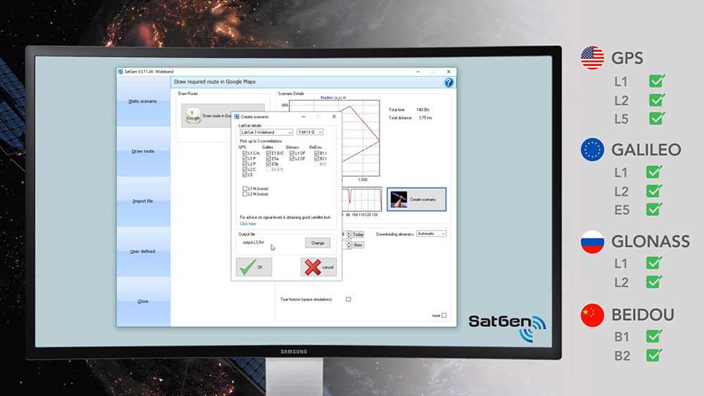
Racelogic Ltd. has released the latest update to its SatGen GNSS simulation software for PC, which now incorporates Galileo RF simulation.
Designed to create a GNSS RF I&Q or IF data file based on a user-generated trajectory file, the updated software can now accurately simulate the European Galileo GNSS satellite constellation alongside existing GPS, GLONASS and BeiDou RF signal generation.
The full range of Galileo frequencies that SatGen can simulate are Galileo E1 B/C, E5a, E5b and E6 B/C (see below for details).
SatGen 3.11.39 Galileo simulated RF frequencies
Galileo E1 B/C. Transmitted by all Galileo satellites on the E1 (1575.42 MHz) frequency, same as GPS L1. Standard precision Open Service signal consisting of Data component B and Pilot component C.
Galileo E5a. Transmitted by all Galileo satellites on the E5a (1176.45 MHz) frequency, same as GPS L5. Open Service signal consisting of Data component I with the F/NAV navigation message and Pilot component Q. Intended to be used together with E1 B/C to improve accuracy.
Galileo E5b. Transmitted by all Galileo satellites on the E5b (1207.14 MHz) frequency, same as BeiDou B2. Open Service signal consisting of Data component I with the I/NAV navigation message and Pilot component Q. Intended to be used together with E1 B/C to improve accuracy.
Galileo E6 B/C. Transmitted by all Galileo satellites on the E6 (1278.75 MHz) frequency. High accuracy Commercial Service signal consisting of Data component B and Pilot component C. Because the content of the C/NAV navigation message is encrypted, SatGen transmits a dummy navigation message, which should be accepted by all receivers.
“Given the vast improvements in navigation and timing that Galileo has brought to its global users, we extremely excited to be releasing a version of SatGen that allows engineers to generate Galileo-specific scenarios for their test procedures,” said Mark Sampson, LabSat product manager.
Other changes to the software include various user interface tweaks, performance optimization and fixes.
For more information on SatGen, contact Katie Harland or call Racelogic LabSat at +44 1280 823 803.
News from the U.S. Army Space and Missile Defense Command/Army Forces Strategic Command
The secretary of the United States Army has designated the U.S. Army Space and Missile Defense Command/Army Forces Strategic Command as the Army’s representative to identify and advocate for positioning, navigation and timing (PNT) information as well as establish and formalize joint navigation warfare, or NAVWAR, requirements.
“Navigation warfare is really about taking a look at different position, navigation, and timing signals and figuring out how the signals flow; the potential for adversaries to disrupt our ability to use them in the future; and how can we not only protect ourselves from the enemy denying us with those abilities, but also how can we do the same to our enemies and affect them and disrupt them in a multi-domain operational environment,” said Col. Timothy G. Dalton, USASMDC/ARSTRAT U.S. Army Training and Doctrine Command, or TRADOC, Capabilities Manager for Space and High Altitude, or TCM SHA.
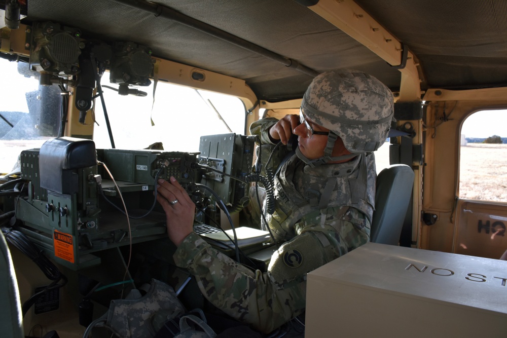
Soldiers in the field learn how to operate in a NAVWAR environment. (Photo: U.S. Army)
What NAVWAR Does. NAVWAR allows the Army to take deliberate defensive and offensive actions to assure U.S. forces PNT information through coordinated employment of space, cyberspace and electronic warfare operations. PNT data enables the Army to precisely move, shoot and communicate; extend its operational reach; control the tempo of operations; and perform mission command, all without adversarial interruption.
NAVWAR capabilities include electronic protection which includes systems and capabilities required to defend platforms and systems against electronic acts in the GNSS electromagnetic spectrum.
The Army has more than 250,000 GPS-dependent systems.
Additionally NAVWAR provides electronic support to sensors and software used to search for, intercept, identify, locate or localize, and report sources of intentional and unintentional radiated GNSS electromagnetic interference for mitigation and planning future operations.
NAVWAR can also provide electronic attack with capabilities to seize and sustain the initiative by actively degrading or denying the GNSS electromagnetic spectrum to adversaries in multi-domain operations.
The Army is dependent on the use of this data with a typical brigade combat team depending on more than 28 different systems and 600 total systems that leverage PNT. The Army has more than 250,000 GPS-dependent systems.
“As the Army goes forward in multi-domain operations, what we see the battlefield becoming is a contested environment,” Dalton said. “What that means is there are adversaries that will look to challenge the United States across all operational phases and domains. These enemies will have the capability to disrupt signals, like GPS, that can impact a wide range of military and civilian activities.
New NAVWAR Concept. SMDC is developing a TRADOC-sponsored Army NAVWAR concept that will be used to establish a baseline for how the Army will execute the NAVWAR fight.
The Army is highly dependent on the use of GPS-delivered PNT data. NAVWAR prevents the use of GPS by hostile forces while ensuring unimpeded use for U.S. forces and allies.
“In the command’s advocacy role we work with the joint and Army communities to examine what the Army needs to be able to accomplish the mission through navigational warfare,” Dalton said. “We work with a community of interest to determine the requirements that will build capability and reduce shortfalls in this mission area.
“This includes activities like updating doctrine, our organizational structure, ability to train the force, and ultimately determine if we need additional equipment, or holistic solutions to protect capabilities and disrupt the enemy on the navigation warfare side,” he added.
Training and Research. SMDC, in conjunction with U.S. Forces Command and the Joint Navigation Warfare Center, supports training events under degraded GPS conditions. The goal is to enable tactical formations to develop and train tactics, techniques and procedures that enable Army formations to work.
“We help develop and focus the capability requirements for the Army,” Dalton said. “But we are integrating with a larger community, led by the Assured Positioning, Navigation and Timing Cross-Functional Team that is focused on modernizing the Army in this mission area.”
SMDC is the Army lead for institutional unity of effort on NAVWAR with several research, development, test and evaluation and capability integration efforts working on the issue independent of one another.
“It is definitely an exciting time for NAVWAR,” Dalton said. “The Army, services and Department of Defense, as a whole, have started to embrace the importance of this mission area and understand the competitive advantage the U.S. and our partners can gain while denying the adversary the ability to conduct operations with respect to navigational warfare.”