Emcore Corporation, a provider of advanced mixed-signal optics products that provide the foundation for defense systems, has acquired Systron Donner Inertial, Inc. (SDI) from Resilience Capital Partners for approximately $25.8 million. Consideration will be in the form of $22.8 million in cash plus 810,698 shares of Emcore common stock.
Highlights of the transaction are as follows:
Expected to increase the navigation systems products to over one third of Emcore’s total revenue; making the aerospace and defense market Emcore’s largest revenue source.
Expands Emcore’s navigation systems product portfolio and accelerates growth through the contribution of substantial additional revenue, which in the unaudited books and records of SDI, totaled approximately $28 million for the 12 months ended March 31, 2019.
Adds additional Raytheon, Lockheed Martin and Boeing 777X programs to Emcore’s existing navigation systems portfolio.
Expected to create material operating synergies in manufacturing, sales and engineering.
Expected to be non-GAAP EPS accretive by the end of calendar 2019
Emcore intends to add SDI’s business to its current navigation product line and support these products from facilities in Concord, California. Through the transaction, Emcore has acquired all of the outstanding assets and liabilities of SDI, including SDI’s 100,000 square foot production facility in Concord.
“This acquisition delivers immediate scale to our growing navigation systems product line and positions Emcore as one of the largest independent inertial navigation providers in the industry,” said Jeff Rittichier, president and CEO of Emcore. “Merging Emcore’s existing navigation systems product line with SDI’s strong brand, technology and backlog, and program wins, instantly creates a stable, growing, and technically advanced business well-positioned to disrupt market norms.
“SDI provides Emcore with a scalable, chip-based platform for higher volume gyro applications, while delivering superior performance compared to its competitors. Combining this business into Emcore will allow us to provide customers with a full product suite that serves a broad range of requirements across both the tactical and navigation grade segments of the market,” concluded Rittichier.
Emcore also announced the appointment of Bruce Grooms to its board of directors. Grooms has extensive senior management and executive experience in both the private sector and the U.S. Navy. From 2015 until June 1, 2019, Grooms served as Raytheon’s vice president of U.S. Business Development, Navy and Marine Corps Programs, where he was responsible for identifying and pursuing U.S. Navy and Marine Corps business growth opportunities for Raytheon and was one of its primary contacts with Navy customers, pursuing opportunities in the evolving cyber area, undersea growth and next-generation strike weapons.
Safran and Orolia are partnering to offer the latest resilient positioning, navigation and timing (PNT) solutions for military forces, especially in GNSS-denied environments.
This partnership will provide mission-critical equipment for air, land, sea and space programs in environments where GNSS signals are not available or degraded. Whether the outage is unintentional or intentional (jamming, meaconing or spoofing), the Safran-Orolia partnership will provide an alternative to GNSS-dependent military systems.
The Safran-Orolia team will offer military forces an unparalleled convergence of PNT capabilities, including Orolia’s portfolio of precise timing references and PNT sensor-fusion technology, as well as Safran’s proven defense inertial navigation solutions. Initial program priorities include navigation warfare (NAVWAR), along with mobile and fixed PNT solutions.
“Today’s military operations are increasingly mobile and global, with mission priorities that often bring them into territories where GNSS jamming and spoofing are becoming common threats,” said Orolia CEO Jean-Yves Courtois. “We’re proud to introduce this unique resilient PNT military partnership to better protect and enable mobile operations for NATO and allied countries worldwide.”
“In a world full of uncertainty, our partnership will provide autonomous and sovereign PNT solutions to Armed Forces facing harsh GNSS denied environments,” said Safran Electronics & Defense Chief Executive Officer Martin Sion.
Orolia’s PNT solutions improve the reliability, performance and safety of critical, remote or high-risk operations. With locations in more than 100 countries, Orolia provides virtually failsafe GNSS and PNT solutions to support military and commercial applications worldwide.
Safran is an international high-technology group, operating in the aircraft propulsion and equipment, space and defense markets. Safran has a global presence, with more than 92,000 employees and sales of 21 billion euros in 2018.
A major use of remote sensing data is to compare images of an area taken at different times and identify the changes it underwent. With a wealth of long-term satellite imagery in open use, detecting such changes manually would be time-consuming and most likely inaccurate.
To address this, EOS Data Analytics has introduced an automated Change Detection tool to its flagship product LandViewer, a cloud tool for satellite imagery search and analysis in today’s market.
Unlike the methods involving neural networks that identify changes in the previously extracted features, the change detection algorithm implemented by EOS is using a pixel-based strategy, meaning that changes between two raster multi-band images are mathematically calculated by subtracting the pixel values for one date from the pixel values of the same coordinates for another date.
This new signature feature is designed to automate a change detection task and deliver accurate results in fewer steps and in a fraction of the time needed for change detection in most image-processing software.
Change detection interface: Images of Beirut city coastline selected for tracing the developments of the past years. (Image: LandViewer)Change detection interface: Images of Beirut city coastline selected for tracing the developments of the past years. (Image: LandViewer)
Applications from farming to environmental monitoring
One of the main goals set by EOS team was to make the complex process of change detection in remote sensing data equally accessible and easy for non-expert users coming from non-GIS industries.
With Land Viewer’s change detection tool, farmers can quickly identify the areas on their fields that were damaged by hail, storm or flooding. In forest management, satellite image detection of changes will come in handy for estimation of the burned areas following the wildfire and spotting the illegal logging or encroachment on forest lands.
Observing the rate and extent of climate changes occurring to the planet (such as polar ice melt, air and water pollution, natural habitat loss due to urban expansion) is an ongoing task of environmental scientists, who may now have it done online in a matter of minutes. By studying the differences between the past and present using the change detection tool and years of satellite data in Land Viewer, all these industries can also forecast future changes.
Top change detection use cases: Flood damage and deforestation
A picture is worth a thousand words, and the capabilities of satellite image change detection in Land Viewer can be best demonstrated on real-life examples.
Forests that still cover around a third of the world’s area are disappearing at an alarming rate, mostly due to human activities such as farming, mining, grazing of livestock, logging, and also the natural factors like wildfires. Instead of massive ground surveying of thousands of forest acres, a forestry technician can regularly monitor the forest safety with a pair of satellite images and the automated change detection based on NDVI (Normalized Difference Vegetation Index).
How does it work? NDVI is a known means of determining vegetation health. By comparing the satellite image of the intact forest with the recent one acquired after the trees were cut down, Land Viewer will detect the changes and generate a difference image highlighting the deforestation spots, which can further be downloaded by users in JPG, PNG or TIFF format. The surviving forest cover will have positive values, while the cleared areas will have negative ones and be shown in red hues indicating there’s no vegetation present.
A difference image showing the extent of deforestation in Madagascar between 2016 and 2018; generated from two Sentinel-2 satellite images. (Image: LandViewer)
Another widespread use case for change detection would be agricultural flood damage assessment, which is of most interest to crop growers and insurance companies. Whenever flooding has taken a heavy toll on your harvest, the damage can be quickly mapped and measured with the help of NDWI-based change detection algorithms.
Results of Sentinel-2 scene change detection: The red and orange areas represent the flooded part of the field,; the surrounding fields are green, meaning they avoided the damage. California flooding, February 2017. (Image: LandViewer)
How to run change detection in Land Viewer
There are two ways you can launch the tool and start finding differences on multi-temporal satellite images: by clicking the right menu icon “Analysis tools” or from the Comparison slider ‒ whichever is more convenient. Currently, change detection is performed on optical (passive) satellite data only; addition of the algorithms for active remote sensing data is scheduled for future updates.
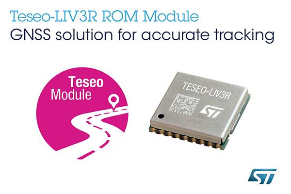
STMicroelectronics has grown its GNSS product offering with the Teseo-LIV3R ROM-based module. The module provides ST’s full GNSS algorithm capability for cost-conscious tracking and navigation devices.
ST’s new GNSS module provides odometer functionality with three trip counters and reached-distance alert, along with geofencing capabilities with up to eight configurable circles and crossing-circles alarm. Support for real-time assisted GNSS with free server access ensures uninterrupted positioning data for dependable navigation.
Simultaneous tracking of GPS, GLONASS, BeiDou and QZSS constellations, with satellite-based augmentation system (S-BAS) and Radio Technical Commission for Maritime Services (RTCM) V3.1 differential positioning ensures excellent accuracy to within 1.5 meters (50% circular error probability, CEP).
Tracking sensitivity of -163 dBm and time-to-first-fix faster than one second ensure high performance for demanding applications. The module is easy to use and responds to proprietary National Marine Electronics Association (NMEA) commands.
With scalable power consumption according to accuracy, average current, and frequency of fixes, a sub-15µA standby mode with RTC backup, and support for multiple low-power modes, Teseo-LIV3R is an ideal choice for battery-sensitive applications. The low-power modes include continuous-fix with adaptive and power-saving cycled modes, periodic-fix with GPS only, and fix-on-demand with the device in permanent standby.
To simplify and accelerate new-product development, the module is FCC certified and is supported by the STM32 Open Development Environment. STM32 applications for advanced geolocation, smart tracking, and server-assisted GNSS are available, while the EVB-LIV3x evaluation board and X-NUCLEO-GNSS1A1 expansion board provide a head-start with hardware. The Teseo Suite PC tool helps easily configure settings and fine-tune performance. Developers can also join the ST GNSS community to share information and increase their understanding of the field.
The Teseo-LIV3R is in volume production. The 9.7mm x 10.1mm LCC18 module is priced from $7.3 for orders of 1,000 pieces.
A link to the live event will be sent to you two hours before the event. Your personalized event URL will be automatically generated by the ON24 system. To ensure receipt of the email, please whitelist this email address by adding it to your contacts: [email protected].
This presentation will begin on at 1 p.m. EDT / 10 a.m. PDT on Thursday, June 27.
Audience members may arrive 15 minutes prior to live time. If you have any questions, please contact event producer Allison Barwacz at [email protected].
Maptitude for Redistricting is designed specifically for anyone involved in or preparing for the 2020 redistricting cycle, from novice to professional users.
Maptitude for Redistricting 2019 has new partisan competitiveness reports, adds access to imagery layers, and allows users to save and share their plans in a variety of formats.
New features include:
Speed improvements provide faster access to maps and geographic analysis.
Expanded file support for Excel worksheets, Google Earth Documents (KML/KMZ) attribute data fields, and MapPoint files.
New partisan competitiveness reports and measures of compactness for analyzing redistricting plans,
Integrated satellite imagery from a variety of sources for giving a better view of district composition.
The latest Census geography and data, including current ACS data.
Maptitude for Redistricting is a professional tool for political redistricting. It provides measures and reports that support the creation of fair and balanced districts.
Maptitude is constantly enhanced and provides tools such as the Efficiency Gap Measure for exploring redistricting problems.
Maptitude was used to democratize redistricting in California and is used by the majority of redistricters, from independent commissions, non-profits, and civil rights groups, to the courts and political parties.
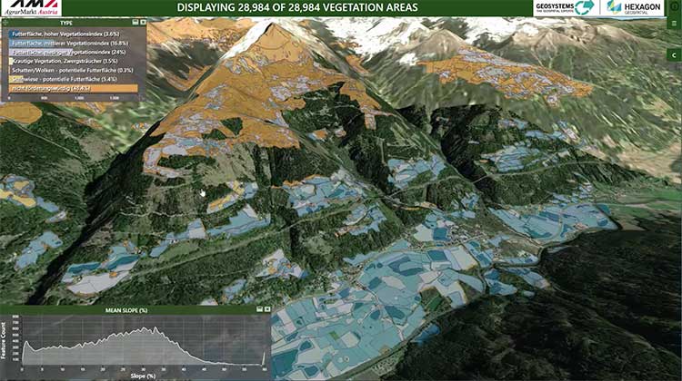
Hexagon’s Geospatial Division launched M.App Enterprise 2019 at its user conference, HxGN LIVE 2019. The latest version of M.App Enterprise integrates capabilities from Hexagon’s Luciad Portfolio to enhance data visualizations, analytics and management.
Designed to monitor assets, evaluate changes, and take action, M.App Enterprise is a privately-hosted platform that allows organizations to deploy Hexagon Smart M.Apps that dynamically address their location-based business problems.
The new features in M.App Enterprise 2019 lay the foundation for users to experience a 5D smart digital reality, where data is connected seamlessly through the convergence of the physical world with the digital and intelligence is built into all processes.
Screenshot: Hexagon Geospatial
“The enhanced M.App Enterprise is now powered by our Luciad technology, which allows users to have the best of both worlds when it comes to data visualization and advanced analytics to communicate information effortlessly, and in real-time,” said Georg Hammerer, chief technology officer – applications for Hexagon’s Geospatial Division. “This unified geospatial enterprise platform can now further enable users and partners to create vertical solutions for their markets and industry segments.”
The Luciad Portfolio integration will allow users to connect to, visualize and examine file-based vector and raster data from their Smart M.Apps in 3D. It also now renders terrain features realistically based on elevation data of the area.
For covering large geographical areas with a higher resolution, M.App Enterprise 2019 allows users to connect to tiled elevation coverages offered by LuciadFusion.
Furthermore, the addition of classification algorithms to the Spatial Workshop user interface enables M.App Enterprise to perform advanced remote sensing with machine learning.
Dean Kemp, defense segment manager for NovAtel, has joined the speakers’ panel for the June 27 complimentary webinar, Advanced Simulation Test Systems for Controlled Reception Pattern Antennas. He will present unique content alongside Lisa Perdue, simulation product manager for Orolia, and Stéphane Hamel, director of testing at Orolia.
Kemp has over 20 years of academic, industrial and business experience in engineering products and services. He spent a significant part of his career involved in antenna design and development, including controlled reception pattern antennas (CRPAs) for GPS anti-jam systems. As Defense Segment Manager, he is committed to precise, assured positioning and timing to address the needs of Navigation Warfare (NAVWAR) professionals and is dedicated to delivering high-quality products into the defense markets.
He holds a Ph.D. in antennas, radiowave propagation and computational electromagnetics from the University of Liverpool and an MBA from the University of Warwick. Prior to joining NovAtel, he worked at API Technologies, Cobham and Cobham Technical Services. His key technical skills include antenna/RF/microwave engineering, software development (Matlab, Fortran, VBA, Python), data analysis and processing, and test and measurement.
CRPAs are advanced, multi-element antenna solutions designed to protect a GNSS/GPS receiver from jamming sources. When combined with antenna electronics, they form an anti-jam antenna system (AJAS). These systems utilize several available technologies and vary in the number of elements.
This webinar will cover the basics of AJAS and CRPA, and the methods used to test them. Details on simulation system configurations, calibration techniques, and use case examples will also be presented. The webinar is sponsored by Orolia, a global provider of GPS/GNSS and resilient PNT solutions to support military and commercial applications.
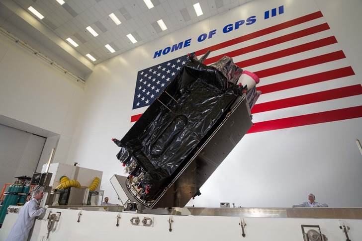
Technicians successfully integrated the U.S. Air Force’s third GPS III space vehicle (GPS III SV03) on August 14, 2017. (Photo: Lockheed Martin)
On May 22, Lockheed Martin delivered the GPS III Contingency Operations (COps) software upgrade to the U.S. Air Force’s current GPS ground control system.
The upgrade will enable the Air Force to start commanding the new, next-generation GPS III satellites now coming off the production line and beginning to launch.
And the new GPS III satellites are coming. The first GPS III satellite launched in December 2018; the second GPS III shipped to Cape Canaveral in March for a July launch; and on May 17, the Air Force declared the third new GPS III “Available for Launch” next.
Ground System. The challenge was modernizing the current ground system — formally known as the GPS Architecture Evolution Plan Operational Control System (AEP OCS) — to fly the legacy constellation, as well as the new, modern GPS III satellites, until the next generation Operational Control System (OCX) Block 1, still in development, is delivered.
To address this, in 2016, the Air Force contracted Lockheed Martin to develop the GPS III COps program. Currently, the AEP OCS controls 31 GPS IIA, IIR, IIR-M and IIF satellites launched between 1993-2016. With the AEP OCS’ new GPS III COps upgrade, the Air Force will be able to command and control both the legacy satellites, as well the more powerful GPS III satellites.
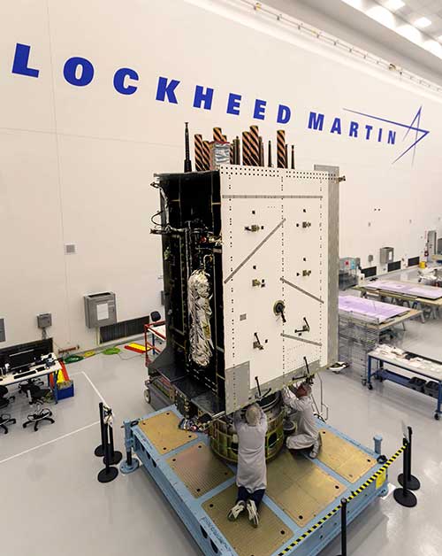
Lockheed Martin shipped the U.S. Air Force’s first GPS III to Cape Canaveral, Florida ahead of its expected July launch. (Photo: Lockheed Martin)
“Positioning, Navigation and Timing is a critical mission for our nation and COps will allow the Air Force to gain early access to its new GPS III satellites,” said Johnathon Caldwell, Lockheed Martin’s vice president for Navigation Systems. “We just finished Final Qualification Testing and delivery on COps, and it will be integrated and installed on the AEP OCS over the summer. We look forward to the Air Force ‘flying’ a GPS constellation on the COps OCS which includes the new GPS III satellites, later this year.”
Meanwhile, the first GPS III space vehicle (GPS III SV01), launched in December 2018, is finishing up pre-operational on-orbit check-out. It continues to be controlled by OCX Block 0 software installed at Lockheed Martin’s GPS III Launch and Checkout Center at the company’s Denver facility. GPS III SV01 is expected to be “handed over” to the COps OCS later this year after the legacy constellation is moved over to the updated AEP OCS.
Lockheed Martin has sustained the AEP OCS since 2013. In November 2018, the company completed the AEP 7.5 upgrade — the largest architectural change in the systems history — replacing significant code, hardware and software to improve the system’s cybersecurity capabilities and positioning the Air Force to better operate in contested, degraded and operationally limited environments.
In December 2018, the Air Force awarded Lockheed Martin the GPS Control Segment Sustainment II (GCS II) contract to continue to further modernize and sustain the AEP OCS through 2025. In 2020, the AEP OCS is expected to receive the M-Code Early Use (MCEU) upgrade, which will allow control of M-code, an advanced, new signal designed to improve anti-jamming and anti-spoofing, as well as to increase secure access to military GPS signals for U.S. and allied armed forces.
Lockheed Martin is under contract to develop and build up to 32 GPS III/IIIF satellites. GPS III will deliver three times better accuracy and provide up to eight times improved anti-jamming capabilities. GPS III’s new L1C civil signal will make it the first GPS satellite to be interoperable with other international global navigation satellite systems. Additional “IIIF” capabilities, beginning at the 11th satellite, will include a fully digital navigation payload, Regional Military Protection, an accuracy-enhancing laser retroreflector array, and a Search & Rescue payload.
Aerial imagery business Nearmap has launched its new 3D product to streamline the way industries such as urban planning, architecture, construction, government and councils view and shape cities across Australia and the U.S.
The company is also previewing its groundbreaking artificial intelligence (AI) technology at its customer event Navig8.
Nearmap 3D allows customers to stream and export 3D imagery on demand at massive scale through its proprietary MapBrowser web application. Because the imagery is updated frequently, businesses can work with the most current information to make more informed decisions.
Nearmap’s new AI technology is turning millions of aerial images — captured over a decade and multiple times a year — into valuable datasets. The datasets can be used to more accurately and efficiently measure change and quantify attributes, such as solar panels, pools, roofs or construction sites.
Organizations ranging from small businesses to large companies and cities will be able to take advantage of AI-driven location intelligence.
“Product innovation is in our DNA. Everything we do has the customer at the core,” said Tony Agresta, executive vice president of product at Nearmap. “Our customers’ worlds are evolving every day. We need to keep innovating to continue to give our customers a competitive advantage through technology breakthroughs like the ones we are sharing today at Navig8.
“Nearmap 3D is the result of a significant investment in R&D, but also listening to our customers and what they need to transform the way they work,” Agresta said. “Accessing 3D imagery up to now has typically been an arduous, time-consuming and expensive process — but not anymore. This represents the single largest, most frequently updated footprint of 3D accessible through a browser. The ability to measure in 3D space, size up an area and then export Nearmap 3D for use in other platforms will transform the aerial imagery market.
“The AI technology that we’re working on will allow organizations to identify locations with specific attributes and in so doing, reduce site visits, generate more leads, and eliminate the time involved to inspect properties manually. Nearmap AI does the heavy lifting so you don’t have to,” Agresta said.
Composite aerial image of Perth, Australia. (Image: Nearmap)
Instant access to 3D through MapBrowser
Nearmap is making 3D imagery accessible to anyone, in the same way it has with 2-D. While Nearmap has offered 3D imagery since 2017, this new iteration of the technology allows users to instantly stream 3D content at massive scale via its MapBrowser web application.
The lightweight platform offers customers an immersive 3D experience, allowing them to visualize cities in 3D from any direction, measure distances, and immediately export a custom area in a variety of 3D formats at unprecedented speed — the download time is a matter of minutes for most requirements and only a few hours for very large footprints.
“It’s like switching from DVDs to streaming services,” said Tom Celinski, executive vice president of technology and engineering at Nearmap. “Our camera technologies have been capturing 3D since 2017, but now our secret sauce is bringing it onto MapBrowser, allowing users to easily and instantly stream this content with many export options. Now users can visualize, measure, define a custom area, export our 3D and use it in their workflows with other commercial platforms and tools. We’re helping 3D experts and novices alike access reality like never before, and this is an important next step in our Reality as a Service journey.”
Nearmap 3D comes with an extensive library, covering more than 400,000 square kilometers. It is updated once a year and covers major urban areas in Australia and the U.S.
“We live in a 3D world, we think in 3D, and so we have to ensure that our products give the closest representation of reality as possible,” Celinski said. “That means businesses that rely on visualizing 3D content, like architects, for example, can now access up-to-date 3D models instantly and export them in just minutes. In a tender process, for example, that can be the difference between winning a new project or not. The opportunities for Nearmap 3D are endless.”
3D image of Manhattan. (Photo: Nearmap)
A living data set
Nearmap AI technology is the result of more than two years’ worth of research and development, and a team of close to 20 data scientists and machine learning engineers. The team, led by Dr. Michael Bewley, is using the petabytes of imagery that the business has captured over the past 10 years and turning it into a living dataset to accurately identify changes or quantify attributes from the Nearmap library of aerial imagery.
Nearmap has built highly accurate machine learning models and deployed them on a massive scale. The automated process, and the constantly learning engine, means that the AI technology can be applied to any new geography. Nearmap also applies the models to new surveys, generating fresh results with current imagery.
To date, Nearmap has performed analysis on over 1 million square kilometers of imagery across Australia and the U.S. (which constitutes about 80 million properties) and is performing more analysis every day. Nearmap is now inviting customers to take part in a beta program to experiment with various use cases.
“We don’t prescribe how our technologies or content can be used by our customers,” said Michael Bewley, director of AI systems at Nearmap. “Our solar customers could use the AI technology to easily identify where and when solar panels have been installed for maintenance jobs, to prospect new clients in an area where solar energy’s popularity is on the rise; or a government entity that previously had the arduous task of tracking swimming pools or construction in their jurisdictions will be able to do it automatically.”
“But this is the tip of the iceberg — we’re just getting started. This technology is going to profoundly change the way that cities are built,” Bewley said. “Our plans include delivering AI results in many forms, much the same way we deliver our imagery today.”
Both technologies will be presented at Nearmap’s flagship event, Navig8, in Perth on June 6, Melbourne on June 11 and Sydney on June 13.
Phase One Industrial has expanded its RS and RSM lens offering with three new high performance lenses for high-altitude aerial photography and long-range aerial and ground inspection applications.
The 300mm AF, 180mm, and 150mm MK II lenses are designed to enhance the performance and flexibility of Phase One Industrial’s iXM-RS and iXM aerial camera series. Each offers precision imagery, taking advantage of the cameras’ ultra-high resolution backside-illuminated (BSI) CMOS sensors, to maintain a smaller ground sample distance (GSD) while flying at higher altitudes, the company said.
Phase One RSM 300mmAF. With the longest focal length in the line-up, this lens offers a 5 cm GSD from 13,000 feet. It fits both iXM and iXM-RS camera models and produces superb image quality by enhancing the cameras’ ultra-high resolution BSI CMOS sensors (3.76 µm pixels).
The lens is designed for both high-altitude 2D and 3D mapping and long-range ground inspection. The motorized lens offers a focus range of 10 m to infinity within which a predefined distance can be set remotely. A self-locking mechanism is built in to secure the focus position against vibrations.
5 cm GSD from 13,000 feet
10 m to infinity focusing range
f/8 – f/32 aperture range
1/2000 sec exposure time
RS Shutter reliability – 500,000 actuations
Rodenstock RS 180mm. Specified by Phase One and built by Rodenstock Photo Optics, Germany, this lens reaches a 5 cm GSD from 8,000 feet when used with the iXM-RS150F camera. The lens supports the camera’s ultra-high resolution BSI sensor for greater image quality and is integrated with a Phase One RS reliance shutter for speed and reliability. The RS 180mm enhances high-altitude aerial 2D and 3D mapping and improves efficiency in oblique configurations.
5 cm GSD from 8,000 feet
f/6.3 – f/22 aperture range
1/2000 sec exposure time
RS Shutter reliability – 500,000 actuations
Phase One RS 150mm MK II. A 5 cm GSD from 6,500 feet is achievable with the RS 150mm MK II lens. It complements the iXM-RS150F camera’s ultra-high 150-megapixel resolution BSI CMOS sensor for acquiring quality images for high-altitude aerial 2D and 3D mapping.
5 cm GSD from 6,500 feet
f/5.6 – f/22 aperture range
1/2500 sec exposure time
RS Shutter reliability – 500,000 actuations
Every Phase One Industrial lens is rigidly built for robustness against vibrations and shocks to meet RTCA DO160G standards, and is individually tested for performance and high-modulation across the whole image area.
Protection from jamming has emerged as the key concern of of both national and organizational/corporate infrastructures. The world abounds in bad actors, and systems based on GNSS signals are uniquely vulnerable. A basic component of any anti-jamming (AJ) strategy is a shielded antenna. An upcoming webinar, June 27, gives a primer and several advanced looks at developing such an antenna-based AJ campaign. Register here for the complimentary webinar.
Anti-jam antennas use techniques, such as nulling or beam-forming, to mitigate the effects of interfering signals. (Image: Orolia)
Controlled reception-pattern antennas (CRPAs) are advanced, multi-element antenna solutions that protect a GNSS/GPS receiver from jamming sources. When combined with antenna electronics, they form an anti-jam antenna system (AJAS). These systems utilize several available technologies and vary in the number of elements.
CRPAs will play an increasing role in the GPS/GNSS landscape. Initially developed in the military domain, they are now entering the civilian market and are poised to bring their benefits to the fields of aerospace, ground transportation, autonomous driving and others. Engineers working with GNSS systems that employ CRPAs and multi-element antennas need special test systems since they need to replicate very specific test conditions that are impossible with live signals.
These complex antenna systems require advanced GNSS simulation equipment in order to be designed and validated, as well as to test their performance. These test systems come in two forms — an anechoic chamber system used to test the CRPA antenna over the air, and a wavefront simulator used to test the antenna electronics with a direct cable connection.
Webinar speakers:
Perdue
Lisa Perdue, Product Manager, Orolia. Perdue is an expert in testing critical GPS and GNSS systems. She has trained hundreds of engineers and technicians who are responsible for high-reliability positioning, navigation and timing applications. She took a lead role in the development of the first GNSS Vulnerability Test System and speaks widely on the topic at many industry conferences.
Hamel
Stéphane Hamel, Director, Testing, Orolia. With a career spanning more than 20 years in engineering test and RF, Hamel has developed many innovative and large-scale products to test semiconductor devices, radios and GNSS receivers. In 2014, he founded Skydel, now part of Orolia. Hamel is one of the architects behind the Skydel SDX GNSS simulator.