NovAtel is offering a sneak peak at its Velocity 2014 magazine, which features an informative technical article on precise point positioning, or PPP. The article, “Advanced GNSS Positioning Solutions with Precise Point Positioning,” discusses how NovAtel CORRECT is designed to optimally handle GNSS constellations and corrections to deliver the best possible positioning solution.
The new Velocity magazine is available at the ION GNSS+ conference in NovAtel’s booth, Booth J.
Anyone not able to attend ION GNSS+ will find Velocity 2014 bundled with the next issue of Inside GNSS, or can email NovAtel.
NovAtel is also offering a significant cost savings on the NovAtel CORRECT with TerraStar PPP positioning solution through September 30.
Broadcom Corporation today announced the industry’s first low-power GNSS and sensor hub combo chip to deliver new always-on location applications for a full range of mobile devices.
The Broadcom BCM4773 minimizes battery drain and adds a new layer of intelligence to location technology on mobile devices by integrating the GNSS chip and sensor hub into a single combo chip. Broadcom’s architecture enables information from Wi-Fi, Bluetooth Low Energy (BLE), GPS and micro electro-mechanical systems (MEMS) to be calculated on a single system-on-chip (SoC) instead of the application processor (AP). This design drives more than 80 percent power savings by offloading from the AP and lowers cost by reducing board area by 34 percent.
“Broadcom today extends its leadership by announcing the industry’s first combo chip that brings GNSS and sensor hub technology together to revolutionize mobile apps in areas such as health, fitness and lifelogging,” said Mohamed Awad, Broadcom director, Wireless Connectivity. “We are proud to make all mobile platforms even smarter by enabling them to dynamically predict and react to consumers’ needs.”
Additionally, Broadcom brings more intelligence to context awareness by integrating GNSS and providing a direct connection to the Wi-Fi combo chip. This allows a mobile device to know where a user is and what the user is doing to further personalize the experience. For example, a BCM4773-based smartphone can use information from Wi-Fi, BLE, GPS and MEMS to recognize when a runner is outdoors versus inside on a treadmill and dynamically manage these technologies to save battery life and optimize the user experience, all without involving the main AP.
Key Features:
Optimized for hardware offload of sensor fusion, on-chip positioning, geofencing and location batching
More than 80 percent power savings compared to standard GNSS receivers
34 percent board area reduction by integrating GNSS receiver and sensor hub
Standalone microcontroller offloads fusing of sensor data from the AP to maximize power savings
Concurrent support for five different satellite systems, including GPS, GLONASS, SBAS, QZSS and BeiDou
Ultra-low power on-chip positioning for background and foreground location using GNSS
On-chip Wi-Fi positioning using a direct connect communication protocol to the Wi-Fi SoC
Batching support for all devices connected to the Location Hub, including Wi-Fi, MEMS and GNSS
Septentrio and Altus will be presenting their high-performance RTK systems at ION GNSS+ 2014. Attendees are invited to learn more at:
The Triple-frequency Multi-system RTK Engine for Challenging Environments (Session A1 room 18, Wed. 9/10 @11:48)
Gap Bridging in Precise Point Positioning (Session B6 room 19, Fri. 9/12 @3:20)
High-performance RTK provides accurate positioning
in urban environments or under dense canopies
while suffering high ionosphere activities or
when coping with sparse networks
for maintaining a smooth transition during outages
Plus, there is no baseline impact, even at greater than 40 kilometers. Visit booth 318/320 in the Exhibit Hall to learn more about the technology behind the performance.
Loctronix Corporation, a provider of positioning, navigation, and timing (PNT) solutions for GNSS-challenged environments, has unveiled the HGX Interference Detection System (IDS) for identifying and monitoring intentional and unintentional interference sources. The IDS is being demonstrated September 10-11 at ION GNSS+ 2014, in Tampa, Florida.
“The IDS can detect sources of interference ranging between 5 dB and 60 dB GNSS jamming to signal (J/S) ratio. Featuring a novel profiling function, the IDS not only detects, but can identify the type of interference given a database of known/previously recorded profiles,” stated Michael Mathews, Loctronix’ CEO and founder.
According to Mathews, “The greater dependence of GNSS within critical infrastructure — including, transportation, communications, finance and the growing availability of jammers — requires new tools to respond to potential threats. The IDS is the first tool to combine the powerful capabilities of Loctronix Spectral Compression Positioning (SCP) technology for identification and characterization of signals with traditional GNSS signal processing to provide full situational awareness of GPS/GNSS operations. The IDS system will benefit government, military, and commercial/industrial applications wherever there is a critical dependence upon quality GNSS data.”
The IDS was developed using the Loctronix HGX hybrid sensor toolkit along with the company’s ASR-2300 ASR Workbench software defined radio platform. The standard implementation supports L1 GNSS bands and measurement rates of 10 measurements per second. Partner-licensed custom/solutions can support multiple bands (such as L2, L5) with greater bandwidths and measurement rates. Multiple sensitivity modes enable monitoring of sub-thermal and high-power interference.
The HGX toolkit API will be available for specialization of the system for custom/embedded applications and adaptation to other hardware platforms. Visit Loctronix in Booth 422.
The GPS World staff reports live from ION GNSS+ in Tampa, Florida, September 9-12, providing news, photos, videos and more. Check back throughout the week for updated information from the event.
GPS World is at ION GNSS+ September 8-12, 2014, at the Tampa Convention Center in Tampa, Florida. Photo: GPS World
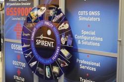
Spirent is exhibiting at the ION GNSS+ 2014. Photo: GPS World
Exhibitors and attendees learn about one of NovAtel’s products. Photo: GPS World
Attendees take a lunch break in the lounge at the Tampa Convention Center. Photo: GPS World
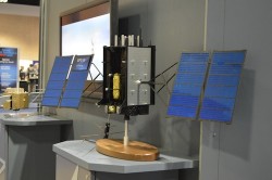
Lockheed Martin is developing the next-generation GPS III satellites (A 1/10 scale is pictured above). Photo: GPS World
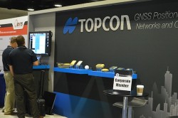
Topcon staff gather to set up their booth before attendees arrive. Photo: GPS World
Attendees learn about StellaNGC by M3 Systems. Photo: GPS World
Antcom antennas featured at the ION GNSS+ 2014. Photo: GPS World
Hannu Laine of Nokia displays one of two tagged remote-controlled cars used in a demonstration of HAIP (High-Accuracy Indoor Positioning), one of seven demonstrations at the Indoor Location and Demonstration panel Wednesday afternoon. Photo: GPS World
VIDEOS
Boeing
Larry Davidoff, director of advanced navigation systems at The Boeing Company, highlights the company’s Position, Navigation and Timing (PNT) system solutions at ION GNSS+ September 9-12 in Tampa, Florida. Jeffrey Goldstein shares digital navigation technology, which includes a GPS-enabled Jeppesen aeronautical aviation chart.
Antcom
Robert Dumont, international sales manager at Antcom Corporation, discusses the rugged GNSS and communication antennas as well as the microwave accessories Antcom manufactures while at the 2014 ION GNSS+ Conference September 9-12 in Tampa, Florida.
Loctronix
Michael B. Mathews, Ph.D., CEO and founder of Loctronix, details the company’s Interference Detection System (IDS) at the ION GNSS+ September 9-12 at the Tampa Convention Center in Tampa, Florida.
KVH Industries
Jay Napoli, vice president of FOG/OEM sales for KVH Industries, Inc., chats with GPS World about fiber-optic gyros (FOGs) while at the ION GNSS+ Conference September 9-12 at the Tampa Bay Convention Center in Tampa, Florida.
NavtechGPS
Carolyn P. McDonald, president and CEO of NavtechGPS, catches up with GPS World at the ION GNSS+ Conference September 9-12, 2014, at the Tampa Convention Center in Tampa, Florida. Franck Boynton, vice president and CTO of NavtechGPS, also shares about simulators with software, the company’s OEM presence and more.
Introduction to ION GNSS+
GPS World Editor and Publisher Alan Cameron discusses the importance of the annual ION GNSS Conference, held this year in Tampa, Florida.
Open Garden, a finalist at CTIA’s Super Mobility Week Startup Showcase, has announced a new generation Mobile Network for IoT devices, and a tracking device is the first to leverage the new technology.
With the increasing number of connected devices and the need for ubiquitous data transmission, device manufacturers are faced with very few options that fit their constraints in terms of cost, device size, battery life, and reliable connectivity, Open Garden said.
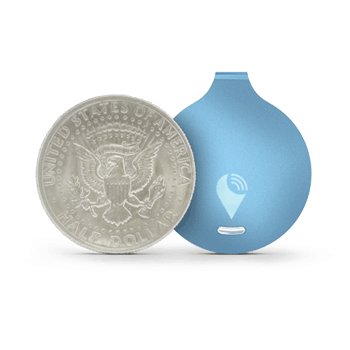
The TrackR easily attaches to valuable items that can then be located via an app using TrackR’s Distance Indicator or via Crowd GPS. Photo: Open Garden
The Open Garden Network makes it easy for devices to seamlessly access other devices and the Internet via secure peer-to-peer connections. Devices automatically detect nearby enabled smartphones or tablets via Bluetooth LE (Low Energy) and can pass data through them securely until the proper destination or recipient are reached. No pairing or configuration are required on the device owner’s part. To enable access to the network, device manufacturers use a simple digital access key, available from Open Garden and its partners.
TrackR, the first device to leverage the new technology, is a small, coin-sized device that attaches to valuable items such as keys, wallet, luggage, or bike. Using the TrackR app for iPhone and Android, a user can locate lost items in seconds. When an item goes missing, the device broadcasts a wireless signal. When another TrackR app user comes within 100 feet of the lost item, their phone sends a message to TrackR’s server with the updated GPS location of the item, and then the owner receives a GPS update on where the item is located.
With the Open Garden Network, TrackR users will also receive GPS updates when users of Open Garden’s apps or partners’ apps or devices come within the range. The system is completely secure and anonymous, the “finder” never knows they found anything.
“Open Garden provides an elegant solution to scale the TrackR community,” said Christian Johan Smith, TrackR’s President and co-founder. “We are excited to partner with Open Garden to expand our Crowd GPS network to deliver the best tracking experience.”
“With the 250,000 devices in the market, TrackR is one of the most successful IoT devices to date. IoT devices require connectivity and simplicity. Because the Open Garden Network is 100-percent software based, it scales infinitely and the costs are extremely low,” said Micha Benoliel, Open Garden’s CEO and co-founder. “Open Garden’s technology also enables operators to generate additional revenues while embracing the IoT revolution.”
Telit Wireless Solutions, a global provider of machine-to-machine (M2M) modules and services, has debuted its first m2mAIR Cloud-ready wireless modules, designed to simplify the development and deployment of comprehensive M2M and Internet of Things (IoT) applications using the m2mAIR Cloud service. Telit said this is an important step toward realizing the company’s vision of the Internet of Things made Plug & Play.
Telit Cloud-ready modules let developers connect and integrate things-to-cloud with just a few simple clicks in little time. Cloud-ready modules feature embedded APIs that are compatible with the well-known Telit on-board AppZone and Python environments and reduce hundreds of lines of code to 16 simple AT commands to move data automatically between remote devices in the field and relevant applications. All the necessary developer resources and support are included and an Evaluation Kit is available for rapid prototyping of custom m2m and IoT device solutions.
The m2mAIR Cloud Platform-as-a-Service, powered by deviceWISE, offers a simple “pay-as-you-grow” usage-based subscription plan — reducing risk, time-to-market, complexity and cost versus building your own point-solution. deviceWISE is an open, developer-friendly, carrier-grade platform, compatible with the TIA TR-50 standard. m2mAIR Cloud features comprehensive management and configuration capabilities to connect, collect, and control anything with bi-directional data transfers between remote devices and the Cloud — from basic entry-level solutions to full-scale enterprise-grade deployments across the globe.
Interested developers can register for a free trial of the m2mAIR Cloud service. According to Telit, the easy-to-use portal has all the necessary visualization tools and dashboards needed for most remote tracking, monitoring and control applications across all industries and markets, out of the box. m2mAIR Cloud also meets the stringent requirements of global organizations that rely on mission-critical reliability, security, scalability and enterprise-grade performance with built-in business system integration. Furthermore, it includesAPIs that lets developers create their own web-based and mobile applications and dashboards, from simple functions to big data analytics.
“When we acquired ILS Technology this time last year, we added the final element needed to become a true one stop shop for companies building IoT applications,” said Oozi Cats, CEO of Telit Wireless Solutions. “Today, we are pleased to have completed not only personnel and operational integration, but also the technology integration to realize our ONE STOP. ONE SHOP vision. Connecting your “things” to the cloud has never been easier. We fully intend to populate the Internet of Things with hundreds of millions of m2mAIR Cloud-ready modules in the coming years to drive innovation that makes businesses and industries operate more profitably, and will change the way people live, work and play.”
The click-to-Cloud simplicity of Cloud-ready Telit modules and the m2mAIR Cloud service will be on display this week in the M2M Zone at CTIA, booth #5628.
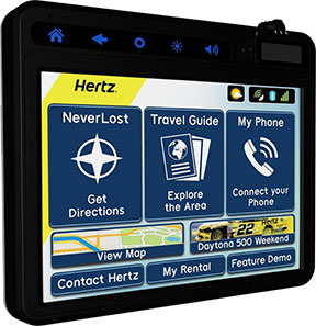
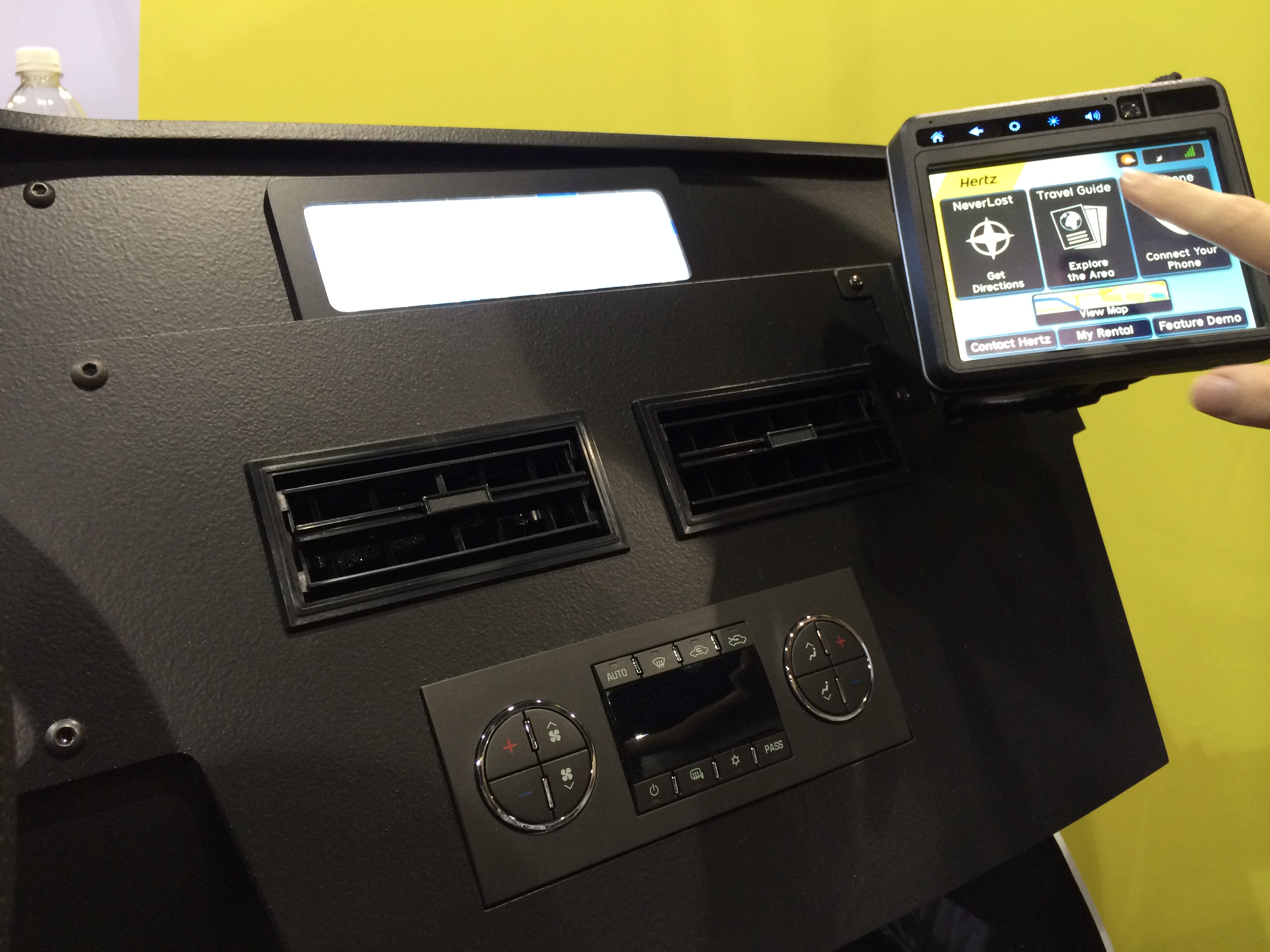
The award-winning in-vehicle system now offers more customization capabilities for travelers along with new navigation tools for convenience and personalization when planning trips. The new system syncs directly with the recently launched Hertz NeverLost Companion app, giving travelers access to more than 10 million U.S. destinations on their mobile devices to plan trips at their leisure, then instantly begin navigation in their Hertz rental.
“Our innovation goes beyond a typical navigation device, offering hands-free calls and instant Bluetooth connection, personal and customizable rental information, exploratory travel guides, weather, flight information, and even access to a concierge to provide the traveler with an enhanced rental experience,” said Mark P. Frissora, Hertz chairman and CEO. “With the latest Hertz NeverLost, customers can experience a new way of trip planning and navigation with a one-of-a-kind travel tool that allows them to see more, do more and discover more.”
Hertz NeverLost is available to rent along with a Hertz vehicle and offers groundbreaking features for rental GPS systems within the car rental industry, including:
Hands-Free Calls – For ease and safety on the road, pair with a smartphone to make and receive calls and access contacts. Phone numbers for points of interest within the device can also be dialed.
Travel Guide – Explore the city and discover local events. Quickly search through thousands of points of interest and get even more out of the trip with accompanying audio, images and descriptions.
Weather, Flights & More – Discover special events and local attractions and get access to weather and flight information.
NeverLost Concierge – Live concierge operators are available to help search for destinations, build custom trips and send route information directly to the NeverLost system.
Companion App – Stay connected with the NeverLost Companion app to sync favorites, explore the area and search for destinations from any location.
My Favorites – Enter download codes or use the USB flash drive to access trips built on NeverLost.com, the Companion app, or excursions built by the NeverLost Concierge team.
Contact Hertz – The device is programmed with all necessary Hertz phone numbers. And with hands-free calling, Hertz can be contacted with a paired smartphone with the press of a button.
Rental Record Info – View current rental record information on the device.
“We’re thrilled to be rolling out the newest version of Hertz NeverLost across the U.S. to offer travelers a sophisticated, yet easy-to-use navigation tool when renting with Hertz,” said Rob Moore, Hertz Chief Technology Officer. “With the instantaneous connection to our new Companion app, the NeverLost system has become a first-of-its-kind within the travel industry, shaping the wave of the future for navigation technology.”
Hertz NeverLost GPS navigation system, demonstrated at CTIA Super Mobility Week, now incorporates Bluetooth connection, hands-free calls, travel guides, weather, flight information and more.
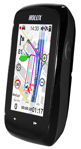
The Holux SporTrek 1305 for avid cyclists features a u-blox positioning module. Photo: Holux
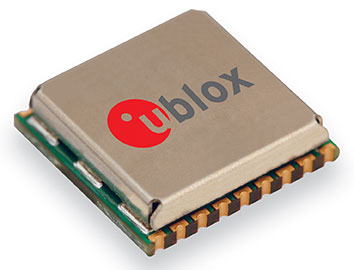
Holux Technology, a maker of professional and consumer GPS products, has launched its next-generation bike computer, the SporTrek 1305, which integrates a u-blox MAX GPS/GNSS module. The new device delivers GPS and wireless health-monitoring features on a compact, three-inch color touchscreen display.
The device delivers a variety of useful information such as speed, heart rate, distance, altitude, map, and route, and comes with a calendar and stopwatch. SporTrek 1305 is the designed for touring, competitive cycling and mountain biking.
The device integrates a compact u-blox MAX GPS/GNSS module that supports GPS as well as GLONASS, QZSS and all SBAS. The module is targeted at applications requiring small size, low power, fast acquisition, and reliable operation in GPS hostile environments.
“Since 1994, Holux has been manufacturing a wide range of battery-operated GPS products for sports, automotive and safety devices. We count on extremely fast, low-power and accurate global positioning technology to deliver the features our customers demand,” said Eddy Huang, director, Marketing & Sales at Holux. “u-blox’ advanced satellite positioning module provides us with the performance, small size, and low power consumption that we need in a consistent, future-proofed form factor.”
u-blox MAX GPS/GNSS module. Photo: Holux
The SportTrek 1305 is shock and water resistant able to operate in all weather conditions. Equipped with Bluetooth Smart for accessories (such as heart-rate straps), it can also connect to heart-rate monitor / combo (speed and cadence) sensors and smartphone connection and notification, providing navigation and performance training data.
It also integrates a patented “carbon reduction” feature that informs the user about the amount of equivalent carbon emissions saved compared to driving, and converts the data into the corresponding number of trees planted to achieve the same effect.
SporTrek 1305 can be integrated with ezTour Plus software to share track route and analysis of physical states, and it can also be used to plan routes using the ezTour Planner feature. Users can integrate their own paper maps and third-party application as well.
Averna, a developer of test solutions and services for communications and electronics device-makers worldwide, has acquired U.S.-based Cal-Bay Systems, a privately owned provider of test systems, test and measurement solutions, automated testing and vibration monitoring tools. This move is intended to strengthen Averna’s presence in the consumer electronics, medical device, and vibration monitoring markets, as well as providing the company with strategic positioning on the U.S. West Coast.
Averna has acquired 100-percent share of Cal-Bay Systems for an undisclosed amount and will take on management of its U.S. and European offices. The current owners, Buck Smith and Patrick Kelly, will continue to participate in the day-to-day operations and expansion plans. Cal-Bay Systems, headquartered in San Rafael, California, brings to Averna 20 years of test expertise and customer relationships in comprehensive, automated test and measurement processes for mission-critical applications.
“We are thrilled with the acquisition of Cal-Bay, as it is very synergistic with our portfolio of test engineering services and expertise, and constitutes another building block of our growth plan,” said Averna President and CEO André Gareau. “Cal-Bay’s customer base and strategic location on the U.S. West Coast are a great addition to our current operations. This is also a fantastic growth opportunity for Cal-Bay’s team and we welcome them into the Averna family.”
Gareau continued, “These are exciting times for our company and shareholders. This acquisition brings a wealth of business opportunities for our company, and could not have been accomplished without the talented team that we have assembled.”
The chief of Russia’s space agency Roscosmos has discussed plans for bilateral cooperation in space with his Chinese counterparts in Beijing, according to the ITAR-TASS news agency.
“On Thursday, the chief of Roscosmos held a meeting with the head of China’s Satellite Navigation Office Ran Chengqi. The officials discussed Russian-Chinese cooperation on navigation satellite systems GLONASS and Beidou, in particular, the placement of Russian stations in China and Chinese stations in Russia,” the Roscosmos press service said.
The two sides agreed to establish a sub-commission for cooperation in the sphere of satellite navigation under the bilateral commission in charge of preparing regular meetings of the two countries’ prime ministers.
Earlier, Roscosmos deputy chief Sergei Savelyev said that Moscow this year would sign an agreement with Beijing on deploying GLONASS and Beidou stations in China and Russia respectively. Each country will accommodate three such facilities.
Scientists and engineers of the GNSS persuasion will want to test their knowledge of the two-body model and Keplerian orbits in a practical application at the roulette wheel in GPS World’s booth, #224–#226, at the ION GNSS+ Conference.
Those successful in their predictions of the fall of the ball will mathematically increase their chances of winning a Go-Pro Hero video camera, a pair of tickets to the fabulous Leadership Dinner, or a bevy of $50 gift cards.
Simply fill out a subscription form and receive five chips for play at the roulette table. Bet odd or even, red or black; bet your favorite number or take a split. If the ball falls into the 0, 00, or 25 slots, all bets on the table, winning or losing, are paid off with a handsome additional stake! This is the magazine’s way of celebrating its 25th anniversary.
The more you win, the more raffle tickets you can put into the drawing bowl for the prizes. The prize drawing will be held during the afternoon break on Thursday, at approximately 3:40.
According to a well-known GNSS expert and ION attendee, “From the point of view of satellite orbital mechanics, the high-speed spinning of a ball within the outer rim of a roulette wheel resembles the orbit of a satellite around a massive body. Friction between the wheel and the ball generates orbital decay that causes the ball to lose speed and, once a certain loss of energy occurs, fall from the rim into the center of the wheel. In the case of roulette, timing the period of motion of both the ball traveling around the rim and the wheel in the center combined with an orbital decay model allows a computer to predict the correct quandrant of the wheel that the ball will settle into as much as 40 percent of the time. Properly implemented, this is enough to create a tremendous advantage over the casino.”
You too can turn your scientific knowledge to lucrative advantage!
GPS World Booth #224–#226 is located at the rear of the hall, adjacent to the attendee lounge. The roulette wheel will be in operation during all exhibit floor hours, including the Wednesday evening reception.