This is the mecca of geographic information systems, or GIS, at least in the United States: the 2014 Esri International User Conference (UC) in San Diego, California, held every July. GPS World and Geospatial Solutions were there in force. A newly dominant technology that got plenty of discussion was unmanned aerial systems (UAS or UAV). Eric Gakstatter, GPS World’s survey and GIS editor, said “I can boil where this technology is headed down to one word: real-time.”
Author: GPS World Staff
-
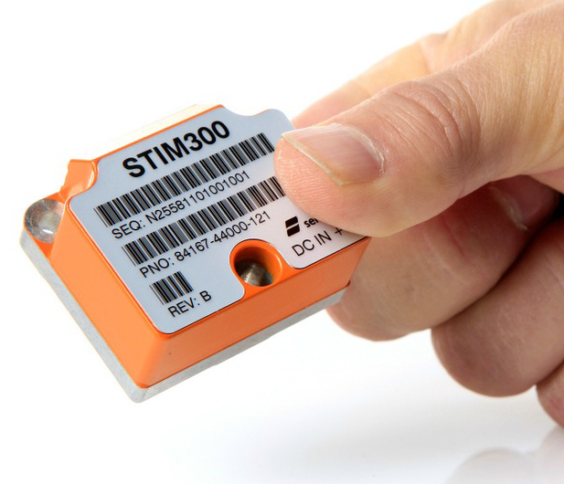
Sensonor Showcases STIM300 IMU at ION GNSS+
The Sensonor STIM300 IMU. Photo: Sensonor Sensonor will be showcasing its STIM300 Inertial Measurement Unit at Booth 102 at ION GNSS+.
The STIM300 is a small, tactical-grade, low-weight, high-performance non-GPS aided IMU. It contains three highly accurate MEMS gyros, three high-stability accelerometers and three inclinometers. The IMU is factory calibrated and compensated over its temperature operating range.
The STIM series is designed for use below and on the ocean, on land, in the air, and in orbit and space. The STIM300 IMU is well suited for stabilization, guidance and navigation applications in the industrial, aerospace and defense markets. It is a crucial building block for inertial navigation systems in UAVs, AUVs, AGVs, UGVs and ROVs, Sensonor said.
The STIM300 is also used for camera turret stabilization and for use in various handheld devices that require a small IMU to secure operations during GPS outage.
-

Lockheed Martin-Built GPS Satellites Reach 200 Years of Operational Life
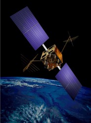
Photo: US Air Force The U.S. Air Force’s fleet of GPS Block IIR and IIR-M satellites, manufactured by Lockheed Martin, have reached 200 collective years of operational life. The 20 satellites make up about two thirds of the current GPS constellation.
Originally launched between 1997 and 2009 to add capabilities to the GPS constellation and to replace other aging satellites, the 12 GPS IIR and eight IIR-M satellites have maintained an availability record of 99.96 percent, which represents only 10 minutes of down time per satellite during all their years of operation.
The 200-year milestone will be celebrated with a brief cake-cutting “ceremony” during ION GNSS, on Wednesday at 12:30 p.m., at the Lockheed Martin booth.
“This is a tremendous GPS operations and sustainment performance milestone, and we applaud the men and women of the Second Space Operations Squadron of the Air Force’s 50th Space Wing, as well as the industry team who support them,” said Mark Stewart, vice president for Lockheed Martin’s Navigation Systems mission area. “The world relies on GPS every day for things like synchronizing global banking and investing, shipping and transportation, search and rescue operations, ATM transactions and even precision farming.”
This spring, the IIR-M satellites played a major role in the continued modernization of the GPS constellation. To help manufacturers develop and test next-generation advanced civil GPS receivers, under the direction of Air Force Space Command and in collaboration with the Department of Transportation, these satellites began early broadcasting of test civilian navigation, or CNAV, messages on a new signal planned for all future satellites.
Making these milestones even more significant is the fact that the GPS IIR and IIR-M satellites were designed to last 7.5 years, or collectively about 150 years. All 12 IIR satellites are currently operating beyond their design life with the oldest operating for more than 16.5 years. Three of eight GPS IIR-M satellites have surpassed their expected life span and all satellites will have done so in 2017.
To meet evolving GPS user demands, Lockheed Martin is developing the next-generation GPS III satellites. These satellites will deliver three times better accuracy, provide up to eight times improved anti-jamming capabilities, and include enhancements which extend spacecraft life to 15 years, 25 percent longer than the newest Block IIF satellites. GPS III will be the first generation of GPS satellite with a new L1C civil signal designed to make it interoperable with other international GNSS.
-
SVN-35 to Resume L-Band Transmission
Starting Friday, September 5, GPS satellite SVN-35 will resume transmitting L-band signals using PRN03, according to a Notice Advisory to Navstar Users (NANU) issued today.
According to GPS World Almanac editor Richard Langley, the resumption is being done in an effort to determine the exact status of SVN-35’s remaining clock. However, the satellite will remain unusable as the Air Force conducts its tests.
Below is the full text of the NANU.
NOTICE ADVISORY TO NAVSTAR USERS (NANU) 2014069 NANU TYPE: GENERAL
*** GENERAL MESSAGE TO ALL GPS USERS ***
On approximately 05 Sep 2014 SVN35 will resume transmitting L-band utilizing PRN03. At L-band activation, SVN35/PRN03 will be unusable until further notice. Additionally, no broadcast almanacs will include SVN35/PRN03 until further notice.
*** GENERAL MESSAGE TO ALL GPS USERS ***
POC: CIVILIAN – NAVCEN AT 703-313-5900, HTTP://WWW.NAVCEN.USCG.GOV
MILITARY – GPS OPERATIONS CENTER at HTTPS://GPS.AFSPC.AF.MIL/GPSOC, DSN 560-2541, COMM 719-567-2541, [email protected], HTTPS://GPS.AFSPC.AF.MIL
MILITARY ALTERNATE – JOINT SPACE OPERATIONS CENTER, DSN 276-3514, COMM 805-606-3514, [email protected]
-
New at ION GNSS+: Live Indoor Demonstrations
A new event highlighting indoor location is being held this year at the ION GNSS+ Conference, which takes place September 9-12 in Tampa, Florida. The two-part event is scheduled for Wednesday, September 10.
The indoor location sessions are part of a new Commercial Track that also covers high-accuracy products, multi-constellation products, new consumer products such as wearables, MEMS, and simulation and testing.
Greg Turetzky, Intel Mobile Communications, is the session chair for a panel discussion from 1:45 to 3:25 p.m. in Room 24 titled “Indoor Location, Standards and Implementations.”
The discussion will cover issues of standardization and certification from key organizations involved in indoor location, according to the ION GNSS+ program. Discussion will focus on the progress and issues for bringing indoor location to a level of standardization to allow penetration into all mobile devices.
Panel members include:
- 3GPP: Kirk Burroughs, Qualcomm
- WiFi Alliance/IEEE: Marc Linsner, Cisco
- Bluetooth Sig/OMA: Ian Blair, Cambridge Silicon Radio Ltd., UK
- FCC/CSRIC: Chris Gates, Nextnav
- Multiple: Steve Malkos, Broadcom
- OGC: Hongwei Liu, MappedIn, Canada
- MEMS Industry Group: Mahesh Chowdhary, ST Microelectronics
- In-Location Alliance (ILA): Jounni Kamarainen, Nokia, Finland
Paul McBurney, GopherHush Corp., is guiding live indoor location demonstrations from 3:55 to 5:30 p.m. in Room 13-16. Demo areas will be set up around the edge of the conference room, and each presenter will have their demo running. In turn, each will talk about their demo from the stage. At the same time, there will be live video of the demo feeding to the big screen on stage. After the demos, panelists will be seated on stage to answer questions posed by the chair, and audience question moderated by the chair.
Demonstration partipants include:
- RxNetworks, Ryan Reilly, “Resolving Indoor Location on Three Axes Using A-GNSS/Wi-Fi/ and Barometric Pressure”
- Broadcom, Steve Malkos, “Enhanced Wi-Fi Ranging with Round Trip Time Measurements”
- CSR, Dave Huntingford, “Indoor Positioning with MEMS, GNSS, Wi-Fi, Signals of Opportunity and Cloud-Based Learning”
- PNI Sensor, Becky Oh, “Pedestrian Dead Reckoning (PDR) Using MEMS Inertial Sensors and PNI Sensor’s Ultra Low-Power SENtral Sensor Hub”
- Indoo.rs, Markus Krainz, “Indoor Location Demonstration”
- Navizon, Inc., Cyril Houri, “Navizon Indoors: A Pedestrian Navigation System Combining the Analysis of Wireless Signals (Wi-Fi, iBeacons) and Inertial Navigation”
- Nokia, Jani Ollikainen and Hannu Laine, “Indoor and Local Positioning with BT Low Energy and Easy Installation”
Learn more about the ION GNSS+ program at the ION website.
-
ION GNSS+ Features Natural Navigation, Commercial Track
ION GNSS+, sponsored by The Institute of Navigation, is considered the world’s largest technical meeting and showcase of GNSS technology, products and services. This year’s conference takes place September 8-12 at the Tampa Convention Center in Tampa, Florida.
ION GNSS+ will bring together international leaders in GNSS and related positioning, navigation and timing fields to present new research, introduce new technologies, discuss current policy, demonstrate products and exchange ideas.
Pre-conference events held Monday and Tuesday, September 8-9, include tutorials and the CGSIC meeting. The conference itself kicks off Tuesday with the plenary session, held 6:30-8:30 p.m.
This year, the plenary speaker is Tristan Gooley, navigator and explorer, who will discuss “The Wonderful World of Natural Navigation.” Gooley has led expeditions in five continents, climbed mountains in Europe, Africa and Asia, sailed small boats across oceans and piloted small aircrafts to Africa and the Arctic. He has walked with and studies the methods of the Tuareg, Bedouin and Dayak in some of the remotest regions on Earth. Gooley will describe how his love of the subject grew over time and explains how he learned to find his way using the sun, moon, stars, weather, plants and animals. He has used natural navigation in the Sahara desert, in jungles, on ice, on oceans and in the English countryside. He will explain how these ancient techniques can be used by anyone willing to try something new and how natural navigation can enrich all journeys, large or small.
Gooley’s talk will be followed by Panel Discussion Lightning Talks moderated by GPS World Publisher Alan Cameron. Presenters include Dr. John Betz, The MITRE Corporation; Didier Faivre, European Space Agency, France; Dr. Frank van Diggelen, Broadcom; Glen Gibbons, Inside GNSS; Oscar Pozzobon, QASCOM S.R.L., Italy; Dr. Frank van Graas, Ohio University; Dr. Todd Humphreys, The University of Texas at Austin; Dr. Dorota Grejner-Brzezinska, The Ohio State University; and Dr. Didier Flament, European Space Agency, France.
Technical sessions will be held Wednesday, Thursday and Friday. This year, a new commercial track has been added.
The program is available for download.
ION has created a short video about “Why You Should Attend ION GNSS+”.
-
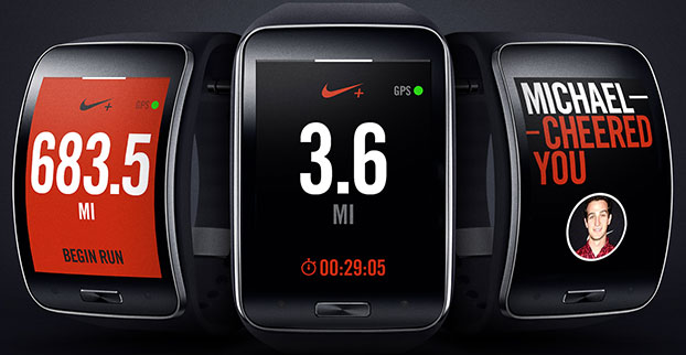
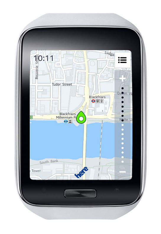
Samsung Offers Gear S Smart Watch with GPS + GLONASS
Photo: Samsung Samsung Electronics has unveiled its next-generation smart wearable device, the Samsung Gear S watch. The Gear S has assisted GPS+GLONASS, as well as 3G connectivity, allowing users to be active while always being able to access their smartphone information.
Designed with a two-inch curved Super AMOLED display and flexible band, the Samsung Gear S is also equipped with an accelerometer, a gyroscope, a compass, a heart rate monitor, and a barometer. The AMOLED display has an easy-to-use interface that allows users to read messages and notifications in a single glance with features such as conversation view and condensed font.
Connected to 3G networks, people can receive notifications from social networks, calendars and applications, even when away from their phones. Users can instantly receive incoming messages and easily reply to SMS using the onscreen keyboard or enhanced S voice functionality. The Samsung Gear S also lets users make and receive calls directly from their wrist as well as getting calls forwarded from a smartphone. The device lets users enjoy seamless communication by freely switching between connections, automatically connecting and synchronizing information once it is paired to a smartphone.
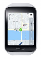
Samsung Gear S smart watch face detail. Photo: Samsung It also provides standalone features such as turn-by-turn pedestrian navigation provided by HERE. Health and fitness features include enhanced multi-sensors, built-in GPS, robust S Health features and applications like Nike+ Running so users can track their runs while leaving their smartphone at home.
“Samsung is leading the exciting and rapidly developing wearable category with continuous innovation that aims to enhance the lives of technology fans,” said Ines van Gennip, marketing director, IT & Mobile Division, Samsung UK & Ireland. “The Samsung Gear S is set to redefine the idea of the smart wearable device and the culture of mobile communication, enabling people to live a truly connected life anywhere, anytime.”
The smart watch will be available in October.
-
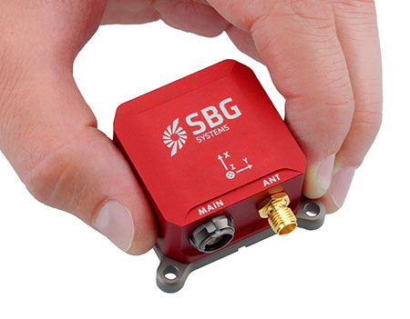
SBG Systems Releases Ellipse Miniature Inertial Sensors
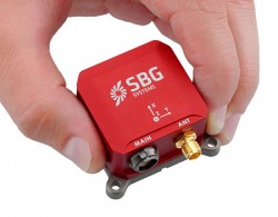
SG Systems’ IG-500 Series of miniature inertial sensors. Photo: SBG Systems SBG Systems has released the Ellipse Series, a product range of miniature inertial systems replacing the IG-500 Series. For the same budget, customers benefit from higher accuracy, advanced filtering and features of high-end inertial navigation systems, the company said.
The Ellipse Series of miniature inertial systems benefits from a new design, new sensors, new capabilities, and new algorithms. “We have selected state-of-the-art MEMS sensors, especially very low noise gyroscopes that greatly enhance Ellipse performance. We integrated cutting-edge GNSS receiver while keeping a small size,” said Alexis Guinamard, CTO of SBG Systems.
“We are able to upgrade miniature sensors capabilities by injecting some advanced and proven filtering and features inspired from high end inertial navigation systems,” Guinamard said. Besides higher accuracy, SBG Systems added for the same budget an improved FIR and rejection filtering, robust IP68 enclosure, high output rate, RTK corrections, and automatic alignment.
Weighting from 45 grams, Ellipse sensors are flexible. The Ellipse-A model provides 3D orientation and heave. For navigation, users can connect their own GPS receiver with the Ellipse-E, or use an internal receiver by choosing the Ellipse-N model. The larger Ellipse-D integrates a survey-grade L1/L2 GNSS receiver with two antennas for heading and position accuracy.
Ellipse A, N, E models are available for order now. The Ellipse-D model will be available in the first quarter of 2015.
-
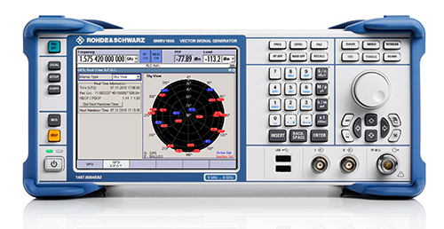
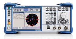
Rohde & Schwarz Demos Latest Simulator at ION GNSS+
 Rohde & Schwarz will be demonstrating its SMBV100A simulator at ION GNSS+ 2014, and is offering a new Wireless Standards poster for visitors to its booth. Rohde & Schwarz will be exhibiting in Booth I during the show, which will be held in Tampa, Florida, September 10-11.
Based on a digital vector signal generator, the SMBV100A supports realtime and hybrid configurations up to 24 dynamic GPS, GLONAS, Galileo, BeiDou and QZSS satellites and can be synchronized for multi-channel RF solutions. Rohde & Schwarz will be demonstrating its latest SMBV100A solutions and technologies along with dedicated solutions to support navigation and GNSS testing including:
- Support realistic user environments: obscuration, multipath, antenna characteristics and vehicle attitude
- Realtime external trajectory feed for hardware in the loop (HIL) applications
- High signal dynamics, simulation of spinning vehicles and precision code (P code) simulations
- Support for ground-based augmentation systems (GBAS)
- Avionics test solutions: VOR, ILS, DME, and TACAN
- Field-to-lab capture and playback solutions
- Interference hunting and direction finding solutions
New Wireless Standards Poster – Register Now!
Conference attendees who stop by Booth I can register for a new Wireless Standards Poster. The convenient wall chart provides an overview of all the major standards for digital cellular, public safety, TV white space, wireless connectivity and GNSS technologies.
Not able to attend? Click here to register to have a poster sent to you.
-
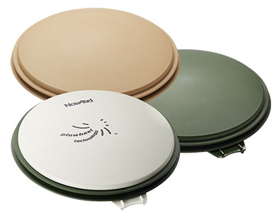
Dual-Frequency Pinwheel Antenna Designed for Optimal Positioning
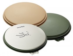
The NovAtel GPS-702-GG-HV high-performance pinwheel antenna comes in three colors. Photo: NovAtel, Inc. NovAtel, Inc., has introduced the GPS-702-GG-HV to its line of high-performance Pinwheel antennas. Tracking L1/L2 GPS and L1/L2 GLONASS frequencies, customers can use the same antenna for GPS-only or dual constellation applications, reducing equipment costs and need for future redesign, the company said.
With the same form-factor and choke ring performance as the company’s other pinwheel antennas, the GPS-702-GG-HV has been enhanced even further to provide the robustness needed for use under high-vibration conditions.
The phase center of the antenna remains constant as the azimuth and elevation angle of the satellites change. Signal reception is unaffected by the rotation of the antenna or satellite elevation, so placement and installation of the antenna can be completed with ease. With the phase center in the same location for both the L1 and L2 signals and with minimal phase center variation between antennas, this antenna is designed for baselines of any length.
Enclosed in a durable, waterproof housing, the GPS-702-GG-HV comes in three colors: NovAtel standard grey, as well as desert tan and olive drab for military customers. The antenna is available for order beginning September 12.
-
Vibrating GPS Shoes Help Lead the Way
An Indian high-tech start-up is offering a GPS-enabled smart sports shoe that vibrates to give the wearer directions, according to an article in gulfnews.com.
The red sneakers count the number of steps taken, the distance traveled, and calories burned. The shoes go on sale this month under the name LeChal, which means “take me along” in Hindi.
The shoes come with a detachable Bluetooth transceiver that links to a Lechal smartphone app to direct the wearer using Google Maps, sending a vibrating signal to indicate a left or right turn.
They are the brainchild of 30-year-old Krispian Lawrence and Anirudh Sharma, 28, two engineers who founded their tech start-up Ducere in a small apartment in 2011 and now employ 50 people. They say they have 25,000 advance orders for the shoes, which will retail at between $100 and $150.

The Lechal app works with Google Maps. Photo: Lechal -
AT&T to Host Hackathon, Demonstrate Connected Platforms at CTIA
AT&T will be a major participant during CTIA’s Super Mobility Week in Las Vegas next week. Connected car, connected home and wearables will all be on display throughout AT&T’s activities:
- The first AT&T Hackathon to take place at CTIA will give developers access to new APIs for the car and home.
- A 60-foot x 40-foot booth showcasing the latest Connected Life products.
- A keynote address delivered by AT&T Mobile and Business Solutions President and CEO Ralph de la Vega and AT&T Mobility President and CEO Glenn Lurie, in which they will host a panel on the Future of Connected Car.
AT&T Hackathon at CTIA
AT&T is kicking off the week’s events with its very first CTIA Hackathon, Code for Car and the Home, which will match developers with companies, tools and services to innovate in the connected car and automated home marketplace. Developers will turn ideas into apps using APIs and other technology resources from 30-plus industry sponsors. More than 300 developers are expected to compete in the two-day Hackathon which begins at 10 a.m. PT on Saturday, September 6, in the Chelsea Theater at the Cosmopolitan Hotel. More than $100,000 in cash and prizes are available.
Connected Life Booth
When the Super Mobility Week show floor opens at 11 a.m. PT on Tuesday, September 9, AT&T will showcase the latest in wearables, connected cars and homes. Volvo and Audi will demo their connected car experiences and a simulator will be on-site to showcase AT&T Drive, the company’s connected car platform. AT&T Drive is a modular, global solution that allows automakers to pick and choose what services and capabilities are important to them in order to differentiate their solutions in the marketplace.
Attendees can also explore how to stay connected to the home by visiting the AT&T Digital Life station. Digital Life is an all-digital, all-wireless automation and home security platform that equips customers with control of their homes from virtually anywhere. On-site activations will include demos such as augmented reality so visitors can learn about the Digital Life service and products, an interactive wall to experience the simple, easy to use Digital Life app and a hologram home to showcase how Digital Life integrates everything you need in one place, to help make your life safer and easier, and provide you with more freedom to live your life.
AT&T is the leader in emerging devices and will showcase the latest wearables from Fitbit, Jawbone, LG, Martian and Pebble. Additionally, Timex, the first authentic watch brand to enter the smartwatch space, will be on-site showcasing the new Timex Ironman One GPS+. The new smartwatch is the first GPS-connected fitness watch to connect to the mobile internet wirelessly, transmitting performance data, location, messages and more.
Also on display will be the AT&T EverThere and FiLIP safety devices. AT&T EverThere is a small wearable device that can detect falls and quickly identify location, automatically connecting the user to a 24/7 call center for response and support. FiLIP is a smart locater for kids that keeps parents and kids in touch at the push of a button.
The booth, number 4423, will be in the Connected Life section of the show floor at the Sands Expo and Convention Center. Visitors can locate the booth by using the interactive floor plan.
Connected Car Keynote
On Wednesday, Sept.10, Ralph de la Vega, president and CEO, AT&T Mobile and Business Solutions and Glenn Lurie, president and CEO, AT&T Mobility, will wrap up the show when they take the stage to discuss the Future of Connected Car.
The following guest panelists will join them on stage to discuss this rapidly growing landscape:
- Mary Chan, President, Global Connected Consumer, General Motors
- Arun Bhikshesvaran, CMO, Ericsson
- Mike Kennewick, Co-Founder and CEO, VoiceBox
- Diarmuid O’Connell, VP, Business Development, Tesla Motors
The keynote will kick off at 9 a.m. PT.