Trimble has introduced the DPS900 Piling System, a dedicated land-based 3D machine control system for a variety of piling machine makes and models. The accuracy of the system allows piling contractors to increase operational efficiency and reduce costs for building structural foundations, retaining walls, coffer dams, and solar or wind farm installations.
“The DPS900 Piling System can transform the way piling contractors work,” said Alan Sharp, business area director for Trimble Heavy Civil Construction. “Without DPS900, the process is manual and often error prone. With the DPS900 system, contractors can take advantage of accurate positioning and automated reporting to ensure machines are being utilized efficiently.”
The DPS900 Piling System reduces surveying costs associated with staking and as-built checks. In addition, the system can increase on-site safety by reducing the number of people around machines, pilings and foundations. Accurate positioning in DPS900 can ensure navigation time between piles is reduced, resulting in increased piling time to maximize production and revenue per day.
Built-in, automated quality assurance and quality control reporting includes capture of start and end positions, time and elevation, as well as actual embedment depth, blow count reporting, and inclination and orientation control. In addition, unique system logins allow managers to filter reports by operator for better accountability, production optimization and forecasting.
Business Center–HCE office software by Trimble is used to create pile plans in the office, and allows for integration with data prep, estimating and reporting functions. Piling machines can be connected to the office using Trimble Connected Site solutions for wireless data transfer and GNSS corrections. In addition, machines can be tracked and monitored using VisionLink for location, hours and utilization information.
The new Trimble DPS900 Piling System is available now in Australia, Europe, North America, Chile and South Africa through Trimble’s SITECH Technology Dealer Channel.
The Mobile Marketing Association (MMA), a global trade association for the mobile marketing industry, is forming a Mobile Location Data Accuracy Group. The focus of the group will be to eliminate any confusion around mobile location data and to improve the trust and confidence brand marketers and agencies have in mobile location advertising and the data that drives it.
Simultaneously, the MMA is forming a Location Leadership Council that will be an industry “think tank” comprised of a merging together of thought leaders from the MMA’s Location and Privacy committees and experts in the various areas of location — marketing, technology, data and policy. Stemming from the council will be a number of working groups, the first of which is the Mobile Location Data Accuracy Group.
The working group will expand on the previously launched Location Terminology Guide, in which the MMA Location Committee identified eight types of location data and signals, and ranked each according to the reach and accuracy of the data. The data and signals to be examined by the working group include (from most accurate to least):
Indoor positioning system
Bluetooth
GPS
Wi-Fi hotspots
Wi-Fi triangulation
Cell tower triangulation
IP address
User reported location
Specifically the Mobile Location Data Accuracy Group will:
Dig deeper into each of these data types and elaborate further on their appropriate uses and limitations.
Develop and issue an RFI (Request for Information) to all location data vendors and validators that will establish criteria with which vendors can be aligned with the data types they use.
Establish strict, standardized definitions with the MRC that vendors will be held accountable to and audited against.
According to an April 2014 BIA/Kelsey study on local media spending, location targeted mobile advertising accounted for 40% of the $7.22 billion mobile ad spend in 2013, and is expected to grow to 52% of the $30.3 billion forecasted for 2018.
“In order to scale mobile marketing specifically driven by location data, it is critical for the industry to come together to develop a common set of definitions of the types of location data available and how they are best used,” said Greg Stuart, CEO, MMA. “By agreeing to and abiding by a common set of best practices and guidelines, MMA members will be instrumental in driving the growth in the industry while assuring brand marketers of the measurable value derived from their mobile efforts.”
With tighter definitions of location data, and the viable uses of such data, measuring results will be more consistent and reliable, the MMA said. These benchmarks will allow buyers to have a much clearer understanding of the data being used, and how it will impact their location-driven mobile advertising campaigns.
Initial members of the group will include:
xAd – Monica Ho, SVP Marketing (co-chair)
Joule – Michael Lieberman, CEO (co-chair)
Factual – Vikas Gupta, Director of Marketing
ThinkNear – Brett Kohn, Director of Marketing
Mobiquity – James Meckley, CMO
Nielsen – Tom Eaton, VP, Client Services
MEC – Bav Panchal, Mobile
OpenX – Rob Kramer, GM, Mobile
Ubimo – Ran Ben-Yair, CEO
Verve – James Smith, CRO
“Having this type of transparency into location data is a huge step forward that will allow us, as buyers, to invest in mobile with increased confidence,” said Michael Lieberman, CEO, Joule North America. “This program will, in large part, allow mobile marketing to truly scale and deliver measurable results for our clients around the world.”
“We are committed to improving clarity and defining auditable standards for location data and ultimately all of location-based services. This will remove the barriers for brands and agencies to leverage the power of this unique mobile value proposition and improve their confidence in how and what to use,” said Monica Ho, SVP Marketing, xAd. “We are excited to work with the MMA and the industry in achieving standards that we believe will be critical for scaling the mobile marketing industry.”
The Mobile Location Data Accuracy Group will be gathering the industry leaders to share initial definitions and use cases at the Location Data Accuracy Panel Session August 26 at the Crowne Plaza Times Square, New York, 6:30-9 p.m. The session will provide an opportunity for brands, agencies and key partners in the location advertising arena to meet and discuss opportunities ahead.
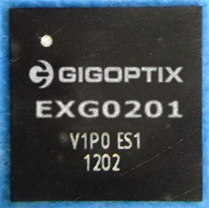
GigOptix, Inc., is making available samples of its newest GNSS RF receiver for road, maritime, agriculture and surveying applications.
GigOptrix is a supplier of advanced high speed semiconductor components for use in long-haul, metro, cloud connectivity, data centers, consumer electronics links and interactive applications, through optical and wireless communications networks.
The new EXG0201 device is expected to be one of several RF-focused products the company will bring to market over the next few quarters stemming from the recently acquired Tahoe RF Semiconductor, now called the GigOptix-Auburn RF Design Center after its integration into GigOptix earlier this month.
The new EXG0201 product marks the introduction of GNSS RF receivers by GigOptix. It is a low-power consumption, highly linear RF GNSS receiver in a small Quad Flat No-Lead (QFN) package. The fully integrated device is optimized for industrial applications and has dual channels supporting both the upper and lower GNSS bands.
The EXG0201 provides two modes of operation, a high-resolution mode and a low-resolution, low-power mode. It integrates RF signal processing, 12 or 3-bit analog to digital convertors, dual fractional-N synthesizers (with a shared reference to generate RF LO signals) and a three-wire SPI digital interface to provide the necessary functionality required to create a high-end GNSS receiver system. All of the EXG0201 sub-systems are programmable through the use of the on-chip SPI interface.
The GNSS industrial market, supporting road, maritime, agriculture, and surveying applications, is expected to grow to 67% in annual shipments to 43 million devices. The road segment dominates the annual quantity consuming about 98% of the total shipments. The road segment’s growth is driven by increased regulatory pressure for E911 emergency location calls.
“The EXG0201 represents our introduction of fully integrated RF-to-bits devices into a growing GNSS market, and serves as a proof point to the strategic importance of the Tahoe RF acquisition. The newly acquired IP and product capabilities put us in an excellent position to provide differentiated solutions and increased business over the long-term,” said Irshad Rasheed, director of marketing for wireless and RF products at GigOptix. “From a capabilities standpoint, the EXG0201 provides excellent performance with 28 MHz of signal bandwidth, dual-channel operation, 60 dB of instantaneous dynamic range, and 75 dB of gain, all contained within a small 72-pin QFN package.”
The EXG0201 is expected to ship in full production quantities starting in the fourth quarter of fiscal 2014.
The U.S. Patent and Trademark Office has issued 10 U.S. patents to TeleCommunication Systems, Inc. during the second quarter of 2014. TCS also received two foreign patents during the quarter.
The 10 U.S. patents describe innovations in messaging, location-based services, GIS/mapping and wireless. They include the following three:
TCS reported in the first quarter that it was issued a Prepaid Short Messaging Services patent. In the second quarter, TCS received notice that another prepaid patent was issued to the company that will serve as one of the cornerstone patents in a monetization program that TCS is planning to launch later this year. The prepaid market has grown into a multibillion-dollar per year industry, with 86 million prepaid users comprising 27 percent of all U.S. wireless users, according to a J.P. Morgan 2013 market report. The recently issued Prepaid Short Messaging patent (U.S. 8,738,496) is a continuation of earlier TCS prepaid patents, bringing TCS’ prepaid messaging portfolio to eight, with one additional pending. Most prepaid phone systems allow users a prescribed amount of prepaid messaging and wireless call time. The ‘496 patent describes techniques for determining if a recipient’s account is sufficiently funded to receive a message. If it is not, the system prevents the delivery of messages until the recipient’s account is sufficiently funded, when follow-on messages will be delivered.
A geofence defines a virtual spatial boundary for creating triggers when a mobile device either enters or exits that boundary. Geofences are commonly used in child location services to alert parents when a child’s mobile device leaves the boundary of a school or park, or by enterprises to track the location of a mobile workforce or equipment. Establishing a geofence can be complicated, requiring that the user manually draw the boundary on an electronic map. The recently issued TCS patent covering a Method and System for Identifying and Defining Geofences (U.S. 8,731,813) describes techniques to simply and easily create geofences based on real-world objects or places. Using the map/navigation application on a mobile device, the user simply selects the desired location, using its pre-defined boundary to create the geofence.
Thousands of portable computing platforms have emerged that have the capability of directly connecting to the Internet either through a wireless wide area network (such as cellular network or campus Wi-Fi network) via a front-end built into the device (smartphone, etc.), or, via Bluetooth or other short-range wireless communication, to a wireless proxy device such as a modem or a smartphone. With various low-cost, short-range wireless devices installed in vehicles for navigation or entertainment purposes, it has become increasingly important to provide an easy and efficient method for a motor vehicle manufacturer, parent or other authority to monitor and control access to certain sites when those devices are connected to the Internet. The recently issued Remotely Provisioned Wireless Proxy patent (U.S. 8,712,408) describes techniques to create white lists (allowed URLs) and black lists (disallowed URLs) within a wireless/mobile device acting as a proxy so that access to certain sites can be controlled effectively.
The remaining seven U.S. patents issued in the period are: Integrated, Detachable Ear Bud Device for a Wireless Phone (U.S. 8,688,174); N-Dimensional Affinity Confluencer (U.S. 8,688,087); Login Security with Short Message (U.S. 8,712,453); Intelligent Reverse Geocoding (U.S. 8,731,585); Secure Location Session Manager (U.S. 8,687,511); System and Method for Location Assurance of a Mobile Device (U.S. 8,718,673); and Wireless Network Tour Guide (U.S. 8,744,491).
First, Lockheed Martin began investigating options for its GPS III payload supply line last year. Then in June of this year, the U.S. Air Force opened a “sources sought” initiative for a production-ready GPS space vehicle, equipped with an alternate payload, for consideration alongside the Lockheed Martin-built GPS III vehicle. Grumman and Boeing have responded to the U.S. Air Force call. Now the U.S. Senate has jumped into the act, with a 2015 defense spending bill that directs the Air Force to allocate at least $20 million for work on a space-based “digital navigation instrument” as a possible alternative to the payload developed for the GPS III satellites.
The Senate Appropriations defense subcommittee stated that it “believes that early Air Force investment, when combined with industry investment, into the development of a digital navigation payload will significantly reduce cost and schedule risk for the future GPS constellation.” What exactly is meant by a “digital navigation payload” — as opposed to the current payload under construction — is unclear. The systems on earlier GPS satellites probably used some analog components. Even modern receivers have an analog front end before the analog-to-digital converter. Perhaps the Senate Appropriations subcommittee wants more digitization in the nav unit.
Disaggregation. Further, the committee “firmly believes that movement away from large satellites, where possible, will result in significant cost savings and reduce the schedule to deliver payloads into orbit.”
This idea calls for dispersing space capabilities away from large platforms and into smaller ones.It would require, at the very least, a new constellation architecture for GPS III, an as-yet unexplored concept.
Status. Lockheed Martin is under contract to deliver the first eight GPS III satellites, but the award for up to 22 further IIIs remains open. Difficulties with the payload for the first batch of satellites mean that although Lockheed has three space vehicles ready, it has no signal payload to put aboard them. Subcontractor Exelis is at work on that.
Lockheed Martin spokesperson Chip Eschenfelder has stated that “signal cross talk issues are resolved. The SV01 navigation payload forecast delivery to Lockheed Martin is fall 2014. Once the first navigation payload is delivered, we are into the production phase.”
General John E. Hyten
General Support. At June’s ION Joint Navigation Conference, General John E. Hyten, currently vice and soon to be commander of USAF Space Command, while evincing unqalified support for the system operators, did not address the GPS III manufacturing and supply issue. He confined his industry-related remarks to warning commercial PNT vendors and government program managers to cease placing commercial GPS receivers in critical government systems that support warfighters, government users, and critical national infrastructure.
He strongly advocated for Selective Availability Anti-Spoofing Modules and M-Code to help secure these critical systems against interference, jamming and spoofing, and urged manufacturers to build their devices in strict adherence to the U.S. government’s ICD process.
FCC Seeks Spectrum but Supports GPS
In a June 20 workshop on “GPS Protection and Receiver Performance,” the U.S. Federal Communications Commission (FCC) reiterated the need to safeguard critical infrastructure and public safety — two key uses of GPS.
Despite fears that the FCC would call for new GPS receiver standards, the meeting took a protective and conciliatory tone, even as the FCC continues to seek more frequencies for mobile broadband, citing the need “get more out of the radio spectrum.”
FCC Chairman Tom Wheeler stated, “Today is not about FCC-mandated receiver standards. Rather it is about the best way to protect GPS operations in the context of evolving technology and adjacent spectrum activities.”
The specter of adjacent spectrum use hovered through the day, fully appearing in LightSquared and administration presentations. Otherwise, scant mention was made of the 2012 notion that GPS receivers should be modified to stop alleged “peeking” into adjacent spectrum.
Panel discussions focused on GPS in critical infrastructure and public safety, with presentations by Qualcomm, Motorola, and AT&T. Speakers from T-Mobile, Spirent, Garmin, NovAtel, and John Deere covered GPS’s role in timing and the power grid, financial markets, telecommunication network, and precision agriculture. Paul Galyean of Deere said that “Certainty on the spectrum environment is needed. It’s difficult to design for the future without it.” If GPS receivers had to filter out cellular activity, this “might impact sensitivity, involve excessive size or cost, and might cause distortion of GPS measurements.”
Chris Hegarty, MITRE Corporation, gave a compelling argument for not overhauling receiver methodology: the extremely long lead times for commercial passenger aircraft. “Until 2022 every new Boeing and Airbus is going to fly off with $250,000 worth of navigation equipment that has three $50,000 GPS receivers and antennas and everything else, and they are going to want to use that for 20 to 25 years. So, you have a timing issue. Even if we all decided today that we wanted to do that, some communities simply aren’t going to be able to get it into place until we’re all dead.”
Power Loss Strikes Galileo Satellite
In-Orbit Validation Vehicle May Be Lost to Further Use
The disappearance of signals from Galileo GSAT0104, the fourth in-orbit (IOV) Galileo satellite, arose from a sudden, unexpected loss of power aboard the space vehicle. The exact cause is unknown, or at least unreported as of press time. Some have speculated that the cause could lie in a failure of components around the solid-state power amplifier, including the output multiplexer, cables, or antenna.
If such proves to be the case, ground operators may be powerless to repair the problem. The satellite would be a total loss.
The power outage flashed on May 27, shutting down the satellite’s E1 signal. The signal “re-established itself almost immediately. But as soon as it was back in service, the two other channels’ power dropped and did not recover. The full satellite then was shut down by ground teams,” reported correspondent Peter de Selding.
Looking for a Fix. European Space Agency (ESA) officials stated on July 3 that they would power-on the satellite again during the week of July 7–11 to continue an investigation into the problem, but there have been no subsequent reports. Investigation has been ongoing since the shutdown but has not identified a cause; officials state they have established that it is not related to the onboard atomic clocks.
The four IOV satellites currently aloft differ in both technology and manufacturer from the next phase of Galileo satellites to be launched. The GSAT0104 satellite now in silent orbit was built by Astrium. The newer, operational satellites are produced by OHB-System, following a different payload design. Two of the newer generation are at the Guyana spaceport awaiting a possible late August lift date.
Reporting History. The possibility of a satellite failure was first floated in the June 30 EAGER newsletter (European GNSS and Earth Observation Report), by contributing editor Tim Reynolds. He wrote:
“Has anyone heard anything from Galileo GSAT0104 recently? According to the European GNSS Service Centre, the fourth IOV satellite is ‘unavailable until further notice.’ The setting of unavailability may be due to in-orbit validation testing, as the website implies may be the case, but no further official statement has appeared, nor active user notifications (NAGUs) at http://www.gsc-europa.eu/system-status/user-notifications.”
Two days later, GPSWorld.com posted a follow-up story: “According to reports, the root cause of the outage is under investigation. Some unofficial sources have gone so far as to speculate that GSAT0104’s useful transmission life may be over.”
Then, on July 3, correspondent Peter de Selding (who also contributes to EAGER) reported in Space News, after questioning sources at ESA, that the trouble aboard the fourth IOV Galileo satellite arose from a sudden, unexpected loss of power, as stated in the first paragraph of this article.
Largest Fine in FCC History — $35M — for Chinese Jammer
The Federal Communications Commission (FCC) plans to issue the largest fine in its history against C.T.S. Technology Co., Limited, a Chinese electronics manufacturer and online retailer, for allegedly marketing 285 models of signal jamming devices to U.S. consumers for more than two years.
The FCC applied the maximum fine allowed to each jammer model allegedly marketed by C.T.S., resulting in a planned fine of $34,912,500.
“All companies, whether domestic or foreign, are banned from marketing illegal jammers in the U.S.,” said Travis LeBlanc, acting chief of the Enforcement Bureau. “Signal jammers present a direct danger to public safety, potentially blocking the communications of first responders. Operating a jammer is also illegal, and consumers who do so face significant civil and criminal penalties.”
C.T.S. operates a website that markets consumer electronics to individuals in the United States, where it allegedly misled U.S. consumers by falsely claiming that certain signal jammers were approved by the FCC. In fact, the use of such devices by U.S. consumers is illegal under any circumstance. C.T.S. also sold 10 high-powered signal jammers to undercover FCC personnel.
The FCC also is ordering C.T.S. to cease marketing illegal signal jammers to U.S. consumers and provide information to the FCC about any persons and entities in the United Sates that purchased its devices.
Signal jammers are radio frequency transmitters that intentionally block, jam, or interfere with authorized communications, such as cellphone calls, GPS systems, Wi-Fi networks, and first responder communications. It is a violation of federal law to market, sell, import, or use a signal jammer in the United States and its territories, except in very limited circumstances involving federal law enforcement.
The FCC asks people to report the sale or use of an illegal jammer by contacting the FCC Enforcement Bureau through the FCC online complaint portal, or by calling 1-888-CALL-FCC (or 1-888-225-5322). To voluntarily relinquish a signal jammer, e-mail [email protected]. Additional information, including a Consumer Alert and Enforcement Advisory to retailers, is available at www.fcc.gov/jammers.
The GPS IIF-6 satellite was launched May 16. Photo credit: United Launch Alliance.
The Air Force is set to launch the seventh GPS IIF satellite this Friday.
An Atlas V 401 will launch the GPS IIF-7 mission for the U.S. Air Force on Friday, August 1, from Space Launch Complex (SLC)-41 at Cape Canaveral Air Force Station, Florida. The 18-minute launch window opens at 11:23 p.m. EDT.
A live webcast of the launch will begin at 11:03 p.m. EDT. To keep up to speed with updates to the launch countdown, dial the ULA launch hotline at 1-877-852-4321 or join the Facebook conversation and follow UA on Twitter using the hashtag #GPSIIF7.
GPS IIF-7 is one of the next-generation GPS satellites, incorporating various improvements to provide greater accuracy, increased signals, and enhanced performance for users.
The Air Force Second Space Operations Squadron indicates that IIF-7, SVN-68/PRN-3, will replace SVN-43 in the F plane slot 3 (F3). SVN-43 will be re-phased from F3 to the F2F slot to replace SVN-26. SVN-33 will be taken out of the operational constellation the day after SVN-68 launch and sent to Launch, Anomaly and Disposal Operations (LADO).
SVN-33 was launched on April 9, 1996, successfully serving over 17.5 years, 10.5 years beyond its design life. SVN-26 will back-up SVN-43 once it completes its re-phase journey.
Galileo’s Early Proof of Concept (EPOC) team has successfully tracked the encrypted Galileo E6-B and E6-C signals broadcast by Galileo satellites. As a result, the Commercial Service loop has been closed using both encrypted and non-encrypted signals, GSA said.
During a 10-day testing period, receivers in Tres Cantos, Spain and Poing, Germany, showed the successful tracking and data demodulation of the encrypted signals from the available Galileo satellites, with periods where all satellites transmitting E6 encrypted signals were tracked simultaneously. The tests verified the Galileo Commercial Service (CS) signal’s encryption functionalities, with the data received containing authentication and high accuracy information previously generated outside the Galileo system. This is an essential feature to ensuring Galileo’s high accuracy and authentication services — some of which may be commercial in nature.
“The Commercial Service has the potential to improve the performance of existing location services for all user communities and therefore will be a key element of Galileo’s service provision,” said Carlo des Dorides, Executive Director of the GSA. “It will also help further enhance the Galileo’s economic added-value in the downstream markets.”
The Galileo Commercial Service will deliver a range of added-value features, including positioning accurate to decimeter level and an authentication element, both of which allow for the development of innovative applications for professional or commercial use. The Galileo CS demonstrator began its proof of concept earlier this year, with early service expected to start in 2016.
Once operational, the CS will provide access to two additional encrypted signals on the E6 band, delivering a higher data throughput rate and increased accuracy. CS addresses the authentication and high-precision market segments and will deliver innovative services with improved performance and greater added value than those obtained through the open service.
“Although there are still many steps before the delivery of an operational CS, these first tests prove what Galileo can do in the near future,” said Ignacio Fernández Hernández, European Commission Officer in charge of the Galileo Commercial Service design and management.
The tests are the result of a collective effort involving teams and projects of AALECS (Authentication and Accurate Location Experimentation with the Commercial Service), supported by the European Commission, the GSA, the European Space Agency (ESA) and the Galileo operator Spaceopal.
The AALECS project is building a platform to connect to the European GNSS Service Centre (GSC) and transmit real time CS data through the Galileo satellites. This platform will be operational by 2015 and will demonstrate the real performance of future high accuracy and authentication services of Galileo prior to early service availability.
The European Commission launched AALECS in January 2014, and it was awarded to a consortium led by GMV including CGI, Qascom, IFEN, Veripos and KU Leuven. As part of the AALECS project, GMV and IFEN developed an early proof-of-concept platform aimed at testing external data transmission through offline means. The project will last for approximately two and a half years.
“This first successful demonstration shows the potential of Galileo to provide a new generation of innovative and high performance satellite-based navigation services,” said Miguel Romay, director of GNSS at GMV. “We are pleased to be part of the team developing the CS demonstrator and contribute to proving the capabilities of Galileo.”
At least some of the work on GPS III continues along prepared tracks, with the award of a Lockheed Martin contract to General Dynamics for two more satellites’ worth of communications hardware. General Dynamics Advanced Information Systems, a business unit of General Dynamics, was awarded a $25.4 million full-production contract from Lockheed Martin to support the GPS III Network Communications Element (NCE) for space vehicles seven and eight (SV 07-08). This commitment fills out that aspect of the current Lockheed Martin bevy of eight bought by the U.S. Air Force.
Many if not all components of the GPS III constellation beyond the Initial Eight have been called into question recently, with the U.S. Senate, the Air Force, and Lockheed itself keeping open minds about alternatives.
General Dynamics’ NCE components provide the communications functions for the GPS III satellites, including the ground-to-space command and control channel, the space-to-space inter-satellite channel and the command and telemetry communications channels within each satellite. General Dynamics is now under contract with Lockheed Martin for GPS III SV 01-08. Delivery of the NCE components for SV03 and SV04 are scheduled for this summer.
Compared to prior GPS vehicles, the Air Force’s GPS III satellites will deliver three times better accuracy, provide up to eight times more powerful anti-jamming capabilities and include enhancements that extend spacecraft life 25 percent further. GPS III-series satellites also will carry a new civil signal designed to be interoperable with other international global navigation satellite systems, enhancing civilian-user connectivity.
The majority of the work under contract will be performed at the General Dynamics Advanced Information Systems facilities in Scottsdale, Arizona, and Bloomington, Minnesota.
Tom Coughlin, head coach of the New York Giant football team, has outfitted his players with GPS devices strapped to their backs under their uniforms. The technology can provide the team with information such as top speed, burst and how long the player has run in terms of time and miles, reports the Wall Street Journal.This is the second year the team has used GPS during training.
“We’re getting all kinds of information,” Coughlin said. “It’s player related so we have information coming every day on every player.”
The data can help the coaches structure practices so they know when to do extra stretching or potentially cut down on repetitions. Some of the players use the information as a means of competition, comparing top speeds and workloads.
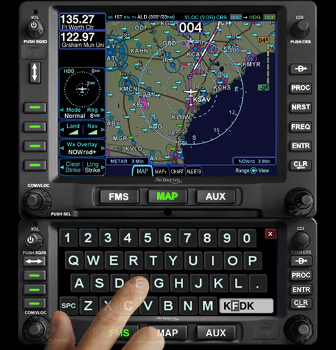
Avidyne Corporation, a provider of integrated avionics and safety systems for general aviation aircraft, has received Technical Standard Order (TSO) approval and an Approved Model List Supplemental Type Certificate (AML-STC) from the Federal Aviation Administration (FAA) for installation of the IFD540 FMS/GPS/NAV/COM system in more than 1,000 aircraft makes and models.
“The IFD540 gives aircraft owners a truly exceptional choice over anything else available today for GPS and VHF NAV/COM capabilities,” said Patrick Herguth, Avidyne’s chief operating officer. “The IFD540 delivers the perfect combination of touchscreen and dedicated-button user interface, making it much easier and more enjoyable for pilots transitioning from previous-generation systems.”
“The IFD540 adds significant improvements in functionality and ease of use, while providing huge cost and time savings for a large number of aircraft owners looking to upgrade their obsolete GPS systems,” said Dan Schwinn, Avidyne’s president and CEO. “Our ‘plug-and-play’ strategy opens up a huge market for aircraft owners who want new features like rubber-band flight plan editing, WAAS and ADS-B, but at a lower cost and with quicker installs.”
The IFD540 is the centerpiece of Avidyne’s previously announced stack of plug-and-play panel-mounted avionics, which also includes the AMX240 Audio Panel and the AXP340 Mode S ADS-B Transponder, both of which are already TSO’d and available now.
A smaller-screen version of the IFD540 called the IFD440 FMS/GPS/NAV/COM is planned for availability later this year.
Rounding out Avidyne’s panel-mounted avionics stack is the DFC90 digital Autopilot with Envelope Protection and Envelope Alerting, which has already been certified on a number of aircraft including Cirrus SR20/22, Piper PA-46, Beech Bonanza series, and Cessna 182 series.
The growth of precision farming market is expected to be remarkable, and is estimated to reach $3.7 billion by 2018, at an estimated CAGR of 13.36% to 2018, according to a report by ReportsnReports. The global population is expected to rise up to nearly 7.5 billion by the year 2020, and the ability to manage and tackle the ever-increasing demand for food will in all likelihood continue, the report says.
Climate Change. Global warming continues to be an influential deciding factor in determining agriculture productivity, as well as soil properties and sustainability of natural resources. The effect of climate change on agriculture is related to variability in local climates rather than global climate patterns. All these concerns marked the way for the entry of the new world of agriculture management practices, the report says. Precision farming can significantly reduce the amount of nutrient and other crop inputs used while boosting yields. Farmers, thus, obtain a return on their investment by saving on phytosanitory and fertilizer costs. The second large-scale benefit of targeting inputs in spatial, temporal and qualitative terms reduce concerns of environmental impacts, the report says.
The major drivers for this market are augmented yield and profitability, which are the major contributing factors for farmers to go for precision farming; other drivers like energy and cost saving and government assistance have also been contributing to the market growth. Major restraints such as high initial investments, and lack of awareness and their impact analysis, are also covered under this study. North America leads the market share for precision farming as this region has the maximum adoption. The Asia-Pacific region (APAC) is the emerging market for precision framing and has been enjoying the highest growth rate among all the geographic regions. It is believed that the APAC market will grow at a CAGR of 25.16% from 2013 to 2018.
The report covers all the technologies, components, and applications of precision farming; it provides a detailed analysis of the current market scenario and estimation for the next five years. Major applications like field mapping and yield monitoring are driving the market. Moreover, the market is driven by some of the most important technologies like GPS and variable rate technologies. This market is already progressing well in developed countries, and it is also expected to grow well in developing nations as a result of their ever-growing food demands.
Companies like Ag Business & Crop Inc., Ag Leader Technology, Ag-Nav Inc., Agco Corporation, Agjunction Inc., Agri Con Gmbh, American Sensor Technologies Inc., Autofarm, Automata Inc., Deere & Company, Dickey-John Corporation, Echelon Ag Inc., Jain Irrigation Systems Ltd., Omnistar, Planting Inc., Precisionagriculture.Com.Au, Raven Industries Inc., Soyl Precision Farming, Teejet Technologies, The Toro Company, Topcon Precision Agriculture & Trimble Navigation Limited are profiled in this research available for purchase.
This report profiles companies which are major players, and are active in this market. The report presents the ‘competitive landscape of the players’ that covers key growth strategies followed by all the major players.
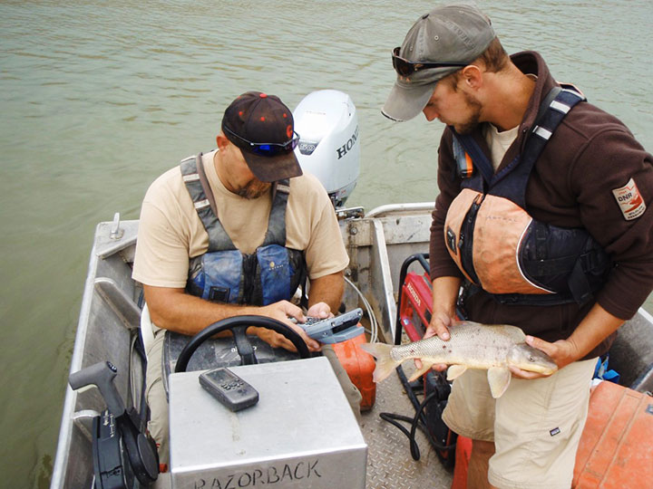
A Utah DWR field crew rides along in an electrofishing boat.
The Utah Division of Wildlife Resources (DWR) is using rugged Juniper Systems handhelds in an innovative way: to remove an invasive fish species from the Green River so that native fish can flourish.
A DWR field crew first used the Allegro MX handheld, loaded with custom fisheries software, to monitor native fish species and remove invasive fish in a 2013 project along the Green River, located near Dinosaur National Monument in Utah’s northeast corner.
The field crew’s work involved boat electrofishing, in which the researchers ride along in a boat with electrodes protruding into the water. The electrodes send out an electrical current, temporarily stunning the fish.The fish float to the surface, where they are netted and inspected.
Invasive fish are collected and removed from the river. Invasive species can degrade fisheries habitats and harm the ecosystem. Right, the Allegro MX handheld.
Every five miles, the crew stopped the boat and collected data on the fish. In a single day on a 12-mile stretch of the Green River, the crew caught 2,800 fish.
When a native species was caught, the fish was given a passive integrated transponder tag. Data was collected about the fish, and then it was released. When an invasive species was netted, however, it was kept for later data collection, and then removed from the river. Invasive species — fish transplanted from another location — can outcompete native fish, degrade fisheries habitats, and harm the ecosystem.
With high-value native fish, the team took a GPS point and collected data on the species, length, weight, sex, ripeness, and more, explained Juniper Systems’ natural resources market manager Trevor Brown, who accompanied a crew.
Brown explained that understanding the location of native fish helps fisheries biologists determine the effectiveness of previous removal efforts: Are native fish prospering in areas where invasive species were previously removed? Location also helps biologists associate where native fish are caught with habitat characteristics, which helps guide more targeted invasive removal efforts.
Allegro MX handheld.
Because the Green River is a a major tributary of the Colorado River, the boat crews submit their data to a central database that supports a larger effort to understand the status and health of fisheries systems of the entire Colorado River watershed. The information is used to guide management and policy decisions, fish regulations, and fisheries research.
“Location-specific data can help biologists understand population and dispersal of both native and non-native fish at a macro level,” Brown said.
The Utah DWR made the switch to the Allegro MX after seeing its benefits, including its full alpha-numeric keyboard, which allowed for rapid, accurate data entry, as well as its extreme ruggedness, sunlight-readable display, integrated GPS, and RFID compatibility.
The team even found the Allegro MX, rated IP67, could float — an additional bonus when working along a river in a shallow craft.
Brown customized the fisheries software for the Utah DWR field crews. The crews previously collected data using pen and paper, and then manually entering it into Microsoft Excel, a time-consuming and error-prone process. The custom fisheries software, available through Juniper Systems, reflects the data that needs to be collected, with required data fields and streamlined data entry. Because many of the Utah DWR crews are made up of seasonal workers, Brown designed the fisheries app to be easy to learn and use.
Biologists use the Allegro MX to collect data on the fish, including this endangered razorback sucker.
Northern Pike. Besides boat electrofishing, the fisheries software can be used for other applications, including an invasive fish removal application called fyke netting. Shaped like a bag with several hoops forming its structure, a fyke net acts as a funnel to trap swimming fish. The Utah DWR uses fyke nets primarily in the spring to trap invasive northern pike while they are spawning. After setting the fyke nets, crews return to check them and collect data on the trapped pike.
The fisheries software is also used for tributary electrofishing data collection, in which wader-clad crews walk along tributaries with electrofishing backpacks, shocking the water. As in boat electrofishing, the crews collect the invasive fish for later data collection, and they tag and collect data on native fish before releasing them.
The team experienced significant improvement with the new data collection process. “[The fisheries software] greatly reduced the data-entry time to the point where it has already paid for itself,” said Joe Skorupski, Native Aquatics Biologist at the Utah DWR. “Last year with three people, we took over 200 hours to enter, verify, and manipulate data. This year, it took one person 20 hours and errors were nonexistent due to the software and new data-collection process. I could go on and on about all the great improvements due to the handheld and the software.”
Since 2013, the Utah DWR has expanded its use of the Allegro MX and software for parallel projects, such as native fish sampling on fast-moving sections (Flaming Gorge) of the Green River, where fewer invasive fish are present.