With more than 80 percent of the world’s oceans unmapped, the deep ocean is one of the last unknown areas on Earth. On May 31, teams with unique exploration solutions were honored with the Shell Ocean Discovery XPRIZE.
XPRIZE is a global competition to advance ocean technologies for rapid, unmanned and high-resolution ocean exploration and discovery. The teams invented new technologies for rapid, unmanned and high-resolution ocean exploration and discovery.
The results were revealed at an awards ceremony hosted at the Oceanographic Museum of Monaco, part of the Oceanographic Institute, Prince Albert I of Monaco Foundation.
The grand prize winner, receiving a total of $4 million, was GEBCO-NF Alumni, an international team based in the United States, while KUROSHIO, from Japan, claimed $1 million as the runner-up.
GEBCO-NF Alumni was led by Rochelle Wigley, Ph.D., and Yulia Zarayskaya, Ph.D. The 14-nation team integrated existing technologies and ocean-mapping experience with a robust and low-cost unmanned surface vessel, the SeaKIT, along with a novel cloud-based data processing system that allows for rapid seabed visualization, to contribute towards comprehensive mapping of the ocean floor by 2030.
Runner-up was KUROSHIO, from Yokosuka, Japan, led by Takeshi Nakatani, Ph.D. The team integrated technologies from their partners to create a surface vessel and software platform that can operate with different autonomous underwater vessels, which increases the versatility of their technology.
Field Testing. To determine winners, the panel of independent judges reviewed data from field testing conducted in Kalamata, Greece, and Ponce, Puerto Rico. In Kalamata, teams had up to 24 hours to map at least 250 square kilometers of the ocean seafloor at five meters horizontal resolution or higher.
The gold-standard high-resolution baseline maps, against which the team maps were judged, were provided by Ocean Infinity and Fugro, while Esri, the global leader in geographic information system (GIS) software and geodatabase management, donated its ArcGIS Online platform for the teams and judges to use.
NOAA Prize. The $1 million National Oceanic and Atmospheric Administration (NOAA) Bonus Prize went to teams for developing technology that could detect a chemical or biological signal underwater and autonomously track it to its source. The award was split between junior high school team Ocean Quest from San Jose, California, which claimed $800,000 as the winner, and Tampa Deep Sea Xplorers, from Florida, taking $200,000 as runner-up.
Additionally, the judges unanimously recommended a $200,000 Moonshot Award for Team Tao from the United Kingdom for its unique approach to seafloor mapping, even though they did not meet the criteria of the competition.
As part of the total $7 million prize purse, four teams opted to compete for the $1 million NOAA Bonus Prize. In a field test in Ponce, Puerto Rico, teams needed to demonstrate that their technology can “sniff out” a specified object in the ocean by first detecting and then tracing a biological or chemical signal to its source.
The judges determined that no single team was able to trace the signal to its source in the timeframe allowed, so the prize was divided among the two teams that came the closest. In 2018, nine finalist teams were awarded an equal share of the first $1 million of the $7 million prize purse, in recognition of their progress-to-date and to support the teams’ continued technological development.
Seabed 2030 and science fiction. As part of its post-prize impact work, XPRIZE announced a partnership with Seabed 2030, a collaborative project between The Nippon Foundation and The General Bathymetric Chart of the Oceans (GEBCO) to inspire the complete mapping of the world’s ocean by 2030 and to compile all bathymetric data into the freely-available GEBCO Ocean Map.
Additionally, and in anticipation of World Oceans Day on June 8th, XPRIZE will launch a science fiction ocean anthology featuring 19 original short stories and artwork set in a future when technology has helped unlock the secrets of the world’s oceans.
No purchase necessary to participate. A purchase or donation will not increase your chances of winning. Participants must be legal residents of the United States and 18 years or older. Void where prohibited.
Official Rules
Sweepstakes begins Saturday, June 1, 2019. Sweepstakes ends Sunday, June 30, 2019. (the “Entry Period”).
How to enter: To participate in the 2019 GPS World State of the Industry survey, entrants must submit an online form located above during the Entry Period. One entry per person. Contact information is the only mandatory information needed to enter. Completing the surveys does not increase your chances of winning. If you do not wish to participate in the survey but would still like to be considered for a prize, please email GPS World’s editor at [email protected] with the subject line “2019 State of the Industry Survey” and include your full name, e-mail address and postal address in the email.
Eligibility: The Sweepstakes is open only to individuals who are legal residents of the fifty (50) United States (including the District of Columbia). You must be 18 years of age or older to be eligible for the Sweepstakes. Employees of North Coast Media, the parent company of GPS World, those involved in the production, development, implementation or handling of the Sweepstakes, any agents acting for, or on behalf of the above entities, their respective parent companies, officers, directors, subsidiaries, affiliates, licensees, service providers, prize suppliers and other person or entity associated with the Sweepstakes and/or the immediate family (spouse, parents, siblings and children) and household members (whether related or not) of each such employee, are not eligible. All U.S., federal, state and local laws and regulations apply. Void in Puerto Rico and where prohibited by law.
Prizes:
Two (2) participants who submit a survey form during the Entry Period will be randomly selected to receive a $100 gift card.
Agreement to Official Rules: Participating in the Sweepstakes constitutes the entrant’s full and unconditional agreement and acceptance of these Official Rules as well as North Coast Media’s Privacy Policy (http://northcoastmedia.net/ncmprivacy.html), which is final and binding. Winning a prize is contingent upon fulfilling all requirements set forth herein. Registrations become the property of North Coast Media. In the unlikely event North Coast Media encounters technical or equipment failures such as telephone network lines failing, computer online system failing, servers and/or provider services cease to be available, or human error in connection with the registration form, etc., North Coast Media will not be held responsible. Collection and handling of personally identifiable information will be in accordance to the Privacy Policy.
Any attempt to exceed the maximum number of entries, whether through use of multiple email accounts or any automated system may result in disqualification. North Coast Media reserves the right to disqualify entrants under suspicion of violations against the terms of Entry. North Coast Media is not responsible for lost, late, incomplete, invalid, altered, unintelligible or misdirected entries, which will be void. In the event of a dispute as to who submitted an entry, the person demonstrating to North Coast Media’s satisfaction, as determined in North Coast Media’s sole discretion, that he or she is the authorized holder of the email account will be deemed to be the entrant. The “authorized holder of the email account” is the natural person assigned by an Internet access provide, online service provider, Internet service provider or other similar organization referencing email address used to post the comment.
Selection of Winners: On July 1, 2019 North Coast Media will select the names of two (2) $100 gift card prize winners in a random drawing of all eligible entries via the GPS World State of the Industry survey forms received during the Entry Period. The odds of being selected as a potential winner depend on the number of eligible entries received during the Entry Period. The potential winners will be contacted via email and asked to provide their full name, age, and mailing address for eligibility within a specified time period. If the potential winner does not respond within the timeframe stated in the notification email, North Coast Media may select an alternate potential winner in his/her place at random from all entries received during the Entry Period.
Requirements of the Potential Winner: The potential winner will be required to return an email to North Coast Media with the winner’s full name, and a valid mailing address. This email and document will affirm eligibility and liability/publicity release within seven (7) days of being notified. If a potential winner fails to return the email confirmation within the required time period, an alternate entrant may be selected in his/her place in a random drawing of all entries received. Acceptance of a prize constitutes consent to use winner’s name and likeness for editorial, advertising and publicity purposes without additional compensation, except where prohibited by law. Failure to comply with any term or condition in these Official Rules may result in disqualification at North Coast Media’s sole discretion.
General Conditions: North Coast Media reserves the right to cancel or suspend the Sweepstakes should – including but not limited to – virus, bugs, unauthorized human intervention, or other causes beyond the control of North Coast Media, corrupt the administration, security, fairness, integrity, or proper operation of the Sweepstakes. Any attempt by any person to undermine the legitimate operation of the Sweepstakes may be a violation of criminal and civil law, and, should such an attempt be made, North Coast Media reserves the right to seek damages from any such person to the fullest extent permitted by law. North Coast Media’s failure to enforce any term of these Official Rules shall not constitute a waiver of that provision.
Release and Limitations of Liability: By entering, participants release and hold harmless North Coast Media Media, respective parent, subsidiaries, affiliates, directors, officers, employees and related entities (collectively, “Releases”) from any and all liability, claims or actions of any kind whatsoever for injuries, damages or losses to persons and property that may be sustained in connection with the receipt, ownership, or use of the prize from or arising out of participation in this Sweepstakes. North Coast Media assumes no responsibility or liability for any error, omission, interruption, deletion, defect, delay in operation or transmission, communications line failure, theft or destruction or unauthorized access to, or alteration of, entries; and/or any incorrect or inaccurate information, whether caused by entrants, printing errors or by any of the equipment or programming associated with or utilized in the Sweepstakes; and/or any problems or technical malfunction of any telephone network or telephone lines, computer on-line systems, servers, or providers, computer equipment, software, failure of any e-mail or entry to be received by North Coast Media due to human or technical error at any web site, or any combination thereof, including any injury or damage to participant’s or any other person’s computer relating to or resulting from participation in the Sweepstakes or use of the prize.
List of Winners: To request winners’ names, send a self-addressed, stamped envelope to: North Coast Media, 1360 E. 9th Street, 10th Floor, Cleveland, OH 44114. Requests must be received by July 5, 2019.
The new senseFly Solar 360 UAV is designed to enable the automated and efficient inspection of solar farms.
Photo: SenseFly
SenseFly has introduced its senseFly Solar 360. Created in collaboration with software company Raptor Maps, the offering is an efficient thermal drone solution that enables the automatic assessment of solar plant performance at a sub-module level, the companies said.
Created by combining eBee X fixed-wing drone technology, senseFly’s Duet T thermal mapping camera and Raptor Maps’ software, senseFly Solar 360 is a fast and fully automated drone. It is easily integrated into solar management workflows without requiring either drone piloting skills or the manual analysis of aerial solar farm data.
“At senseFly we are continually looking across the industry to identify new commercial partners with whom we can bring to market what our customers need, which is vertically-focused end-to-end solutions,” said Gilles Labossière, CEO of senseFly.
“With Raptor Maps, we are collaborating with a true solar industry pioneer,” Labossière said. “Their software takes the guesswork out of solar farm inspection and, crucially, speeds up this process — from days down to hours. This efficiency, combined with the eBee X’s large coverage and reliability, ensures that farm owners and operators — or the drone service providers they employ — can inspect utility-scale solar farms more quickly, easily, and accurately than ever before.”
“Solar power is the largest source of new energy generation in the world,” said Nikhil Vadhavkar, CEO of Raptor Maps. “This rapid growth has fueled demand for industry-specific solutions to allow solar customers to scale. Our enterprise-grade software has been deployed across six continents and 25 million solar panels to increase power production and reduce risk and maintenance cost across solar portfolios. We are proud to collaborate with senseFly, the industry leaders in commercial fixed-wing drones, to increase access to Raptor Maps while providing a comprehensive, end-to-end solution that scales with the solar industry.”
We’ve all been there before: static on our wireless call or, worse, the call drops at the most inopportune time. Like instant response when we surf the web, consumers have come to expect clear, consistent call connections when using mobile. With too much of a bad thing, the churn risk soars to untenable heights.
5G, shorthand for Fifth-Generation Wireless Systems, holds the promise of transforming our daily lives. Using massive bandwidth, extremely low latency and high speeds, almost everything that requires sending and receiving data gets a boost. Unique radio frequencies transmitted with precise directions improve on the older 4G approach by taking advantage of higher frequencies. The signals take less time to transfer from one device to another, dramatically reducing wait times.
How does this help business and the consumer? Video conferencing is better, call connections are clearer, and smart homes get their Ph.D. How does this become reality?
Rather than using satellite-based towers, 5G depends on shorter signals using antennas and other transmission devices installed closer to the ground, on the tops of buildings and existing utility poles. Herein lies the rub. Ground features such as trees or tall structures can interfere with transmission. On top of this, there’s the need to plan for change. Vegetation grows over time, new construction takes place, and the cycle of interference continues. Imagine trying to plan a 5G network in an urban environment replete with hundreds or thousands of tall buildings. How would a telecom decide where to place the hardware and optimize the network?
The answer rests in aerial imagery, also known as aerial mapping. Rather than relying on satellite imagery that’s less clear and prone to atmospheric conditions, high-resolution camera systems mounted inside planes are photographing the world — all in 3D. Within predefined coverage areas, every point on and above the ground is being photographed and transformed into a variety of 3D models. For the telecom industry, planners can predict zones of interference and place hardware accordingly. They can better service their customers and quickly adapt to changing conditions in support of maintaining the network.
One type of output from these advanced camera systems is called a digital surface model, providing detailed elevation profiles of ground features, building, bridges, you name it. Also knows as DSM, the elevation detail contained within the imagery facilitates analysis to optimize the placement of 5G antennas and transmission devices.
When combined with other forms of imagery that allow users to clearly visualize every aspect of the landscape in photorealistic, immersive 3D, this enables telecoms to quickly model all the transmission permutations.
These high-tech companies use machine learning to identify clear signal areas and sections of the landscape where a tree, for example, may degrade the 5G radio frequency. Armed with such intelligence, strategic placement of hardware unlocks the optimized network — all without having to leave the office to collect data from the field.
The race is on to roll out 5G. Fortunately, advances in aerial photography have been combined with machine learning and artificial intelligence (AI) to speed up network planning and change modification. With tens of thousands of access points needed for large cities, advanced uses of aerial imagery and data science provide the answer for fast 5G deployment.
Less than a decade ago, mobile mapping systems were being designed and sold using computer systems that rivaled most desktop computers. Mobile mapping vehicles had to be custom-fit for large displays and computer systems, usually with large, expensive, bulky redundant arrays of inexpensive disk (RAID) storage systems that would consume the back of a van or, at the very least, the back seat of a car. Wiring for these systems completely entangled the vehicle, making it a dedicated part of the mapping system. Many of these systems are still being used today, as their utility is only lost on space consumed but not on usability or productiveness.
In 2019 we face the ever-increasing demand for smaller size with greater performance, especially in the instance of UAVs, where size, weight and power consumption are precious commodities.
Wires? Nobody wants or expects to see any wires or cabling running between devices, with the possible exception of power. A desktop computer, laptop or RAID system is no longer a consideration. Storage is replaced by high-speed, high-capacity media such as Compact Flash, Flash memory cards, and solid-state drives.
And all of those wires? They are replaced by Wi-Fi or Bluetooth working directly between the onboard microprocessor (at most the size of a deck of cards) and what else? Your cell phone. Maybe a tablet.
The inertial navigation system inside these UAVs, the central nervous system of a mobile mapping set-up, can no longer afford to weigh several kilograms. It must weigh under 1 kilogram, with less than 500 grams preferred. The accompanying antennas must also shrink.
At the same time, cost must drop while performance must be maintained or improved. More users will adopt the technology, and they will no longer be experts. Reliability and durability will be of utmost importance.
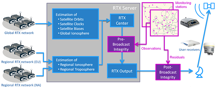
The Trimble CenterPoint RTX correction service, enabling centimeter-level absolute positioning around the world without the need for RTK reference-station infrastructure, is now available to many users, including integrators of professional high-precision equipment and consumer products such as in the automotive sector. Access is provided via a software library compatible with any GNSS device. The corrections now contain detailed integrity information for safety-critical applications.
The RTX infrastructure is made up of approximately 120 globally distributed RTX reference stations. Receivers at these stations transmit measurement data at 1 Hz to the RTX server centers, where the correction data is computed. For redundancy purposes, multiple servers in the United States and Europe are operated. A failsafe architecture avoiding any single point of failure in the processing chain has produced a very high availability of corrections. Today the system supports GPS, GLONASS, Galileo, BeiDou and QZSS satellites. It is a multi-frequency system supporting two or more frequencies for each satellite system.
The correction stream is available to users using L-band signals broadcast via geostationary satellites and IP connections. The L-band transmitted RTX data stream uses a bandwidth of 600–2400 baud, and a highly compressed data format with a resolution of 1 millimeter, with an average latency of 8 seconds in L-band mode and 5 seconds in IP mode. The data stream is encrypted via an Advanced Encryption Standard (AES) with a key length of 256 bits to guarantee safe transmission. Data transmission integrity is assured with a 32-bit cyclic redundancy check attached to every message. The RTX correction stream provides information on satellite position, satellite clock, ionospheric and tropospheric models, and code and phase biases.
The orbit determination is done in real time using a reduced dynamic approach with dynamic models and exploiting the accuracy of the phase measurements after ambiguity fixing. Based on the computed orbits, the satellite clocks are estimated at 1 Hz, where integer ambiguity fixing is performed for the different satellite systems.
Next, a single-layer global ionospheric model is computed and represented through spherical harmonics. There are currently two areas with a denser network than the global network; these cover Europe and the mainland U.S. with more than 1,000 base stations. Using these stations, regional ionospheric and tropospheric models are computed, which then provide a fast convergence (RTX-Fast service).
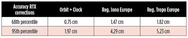
The satellite position and clock information has centimeter accuracy and allows the client to compute precise point positioning (PPP) with carrier-phase ambiguity resolution. Table 1 shows service accuracy.
Table 1. Accuracy of the RTX corrections from more than three years (June 2015–July 2018) of residuals computation in the European RTX-Fast network. (Table data: authors)
Once the ambiguities are resolved, the position solution is accurate to a few centimeters. The global RTX-Standard service provides convergence times of 7 minutes to 20 centimeters (cm) horizontal error (95%) and to 2.5 cm (95%) in 13 minutes as shown in Figure 2. The regional RTX-Fast service (U.S., Europe) provides convergence times of less than a minute with centimeter accuracy. The warmstart convergence time is approximately 13 seconds.
Figure 2. Global convergence of RTX out of 52 globally distributed stations covering one month of data. (Image: Trimble)
The accuracies specified are achievable with precise Trimble GNSS positioning hardware. For integration into non-Trimble devices, an RTX software library is offered, which gives the user real-time access to the individual data in the RTX correction stream. For use of this library in safety-critical systems such as advanced driving-assisted systems (ADAS) or semi-automated driving, this library was certified to follow the ASIL-B ISO 26262 standard and the automotive ASPICE standard. This library is available for easy integration into third-party applications.
In addition to the real-time RTX solution, a web-based post-processing solution is available for public use free of charge. It is possible to upload static Trimble or RINEX files to the server, post-process the measurement data, and retrieve a precise position in various coordinate frames.
Service integrity is continuously monitored at independent stations from the RTX tracking networks in Europe and the US. The integrity of the service is provided at the correction data domain. The integrity monitoring part of the RTX system minimizes the risk due to events such as unplanned satellite maneuvers or wrong broadcast ephemeris; satellite signal or clock anomalies; ionospheric storms; or problems in transmitting the RTX correction stream.
The monitoring stations compute phase observation residuals (with ambiguity fixing) using the station measurements and the received RTX corrections. These residuals represent the actual errors of the corrections as seen by the monitoring stations at the line-of-sight (Table 1). The thresholds at which corrections are considered as faulty are the following: 0.5 m + QI (quality indicator) for orbit + clock corrections and regional tropospheric models, and 1.0 m + QI for regional ionospheric models.
The integrity monitoring consists of two steps (Figure 1): a pre-broadcast check, where potentially faulty corrections are detected and filtered out before leaving the computing server, and a post-broadcast check, where additional errors in the transmission channel are detected and alarms are issued to the users.
Figure 1. Generation and transmission of RTX global and regional corrections, including pre- and post-broadcast integrity monitoring. (Image: Trimble)
Integrity flags and alarms are constantly inserted into the correction stream and output by the RTX client library. The integrity information notifies clients of the presence of integrity monitoring and provides timely alerts in case of detected correction-data integrity violations. The time-to-alert limit goals are 17 seconds for L-band transmission and 13 seconds for IP transmission for the RTX service.
The RTX corrections includes quality indicators. In particular, the quality indicator for the satellite clock includes a “DoNotUse” flag to indicate potential problems with the given satellite. This flag prevents the use of the satellite for positioning when received by the user. The quality indicators of the corrections are indeed a first integrity layer. In 2017 the pre-broadcast integrity monitoring was added to act as a second layer. In 2019, with the addition of the post-broadcast integrity monitoring, a third integrity layer was added to the RTX correction data stream.
The RTX system provides access to centimeter-level corrections allowing centimeter positioning on a global basis. RTX-Fast services are available in Europe and the U.S. with pre- and post-broadcast integrity monitoring currently being deployed.
The authors are engineers with Trimble Terrasat GmbH, Germany.
Blue Marble Geographics has released a new version of the Global Mapper software development kit (SDK), providing software engineers with the means to embed the latest geospatial technology into their custom applications.
Blue Marble’s GIS software has been used by GIS professionals for 25 years. Users come from all industries including software, oil and gas, mining, civil engineering, surveying and technology companies, as well as government departments and academic institutions.
Global Mapper’s GIS application is capable of displaying, converting and analyzing virtually any type of geospatial data. The Global Mapper SDK and accompanying Lidar Module SDK provide software developers with a toolkit for accessing much of this functionality from within an existing or custom-built application.
The SDK also enables the creation of custom toolbars and extensions to enhance the data processing and analysis functionality of the standard version of Global Mapper. This capability allows in-house developers to create a unique version of the application to meet their specific needs or for software companies to build custom products for commercial distribution.
Highlights of the latest version of the SDK include:
A new function to allow querying of elevation from a specific list of elevation layers
Significant speed improvements when working with vector data with attributes
Faster viewshed calculation on computers with multiple cores
Support for downloading vector features from Esri RESTful data sources
S-52 point symbols for S-57 and S-63 marine chart files
Updated SHIFT_LAYER script command to support shifting in the Z (elevation) direction.
Support for several new formats including, OpenFlight and HEC-RAS raster and vector files
The supplementary Lidar Module SDK now offers:
The ability to select points based on their proximity to other lidar points and/or line features
A new option to update the return number/count when deleting multi-return points
“Global Mapper’s reputation as a powerful geospatial data processing and analysis application is well known throughout the world and software engineers are increasingly integrating these tools into a wide variety of development projects,” said Patrick Cunningham, Blue Marble president. “The Global Mapper SDK is unrivaled in its ease of deployment, data format support, affordability, and in its adaptability, allowing it to meet the ever-changing needs of today’s geospatial software development sector.”
How will wireless technologies most significantly drive change and innovation in the surveying industry?
Miguel Amor
“GNSS by design, by physics, will always be challenged in urban settings. 5G and GNSS will provide a step to ubiquitous positioning in built-up areas — a blend of relative and absolute positioning, terrestrial and satellite-based measurements.” Miguel Amor Hexagon Positioning Intelligence
Greg Turetzky
“The improvements in bandwidth and latency of 5G will create new opportunities for edge and cloud-based computing advances such as AI and machine learning to penetrate surveying, as 5G is doing in other industries, to improve efficiency, accuracy and automation.” Greg Turetzky Consultant
Members of the EAB
Tony Agresta Nearmap
Miguel Amor Hexagon Positioning Intelligence
Thibault Bonnevie SBG Systems
Alison Brown NAVSYS Corporation
Ismael Colomina GeoNumerics
Clem Driscoll C.J. Driscoll & Associates
John Fischer Orolia
Ellen Hall Spirent Federal Systems
Jules McNeff Overlook Systems Technologies, Inc.
Terry Moore University of Nottingham
Bradford W. Parkinson Stanford Center for Position, Navigation and Time
A link to the live event will be sent to you two hours before the event. Your personalized event URL will be automatically generated by the ON24 system. To ensure receipt of the email, please whitelist this email address by adding it to your contacts: [email protected].
This presentation will begin on at 1 p.m. EST / 10 a.m. PST on Thursday, May 16.
Audience members may arrive 15 minutes prior to live time. If you have any questions, please contact event producer Grace Rybak at [email protected].
The GPS World and Geospatial Solutions staff are reporting live from the Association for Unmanned Vehicle Systems International’s (AUVSI’s) Xponential 2019 April 29-May 2 in Chicago.
The event convenes the global community of commercial and defense leaders in intelligent robotics, drones and unmanned systems. Check out news, photos and videos from the show.
Raytheon Company’s advanced high-power microwave and mobile high-energy laser systems engaged and defeated multiple unmanned aerial system targets during a U.S. Air Force demonstration. The mature HPM and HEL technologies offer an affordable solution to the growing UAS threat, the company said.
Raytheon made the announcement at AUVSI Xponential, which took place April 29-May 2 in Chicago.
Raytheon’s mobile high energy laser looks out into a wide-open sky. The company’s advanced high-power microwave and high-energy laser engaged and defeated dozens of unmanned aerial system targets in a recent U.S. Air Force demonstration.
The HEL system, paired with Raytheon’s Multi-Spectral Targeting System, uses invisible beams of light to defeat hostile UASs. Mounted on a Polaris MRZR all-terrain vehicle, the system detects, identifies, tracks and engages drones.
“Countering the drone threat requires diverse solutions,” said Stefan Baur, Raytheon Electronic Warfare Systems vice president. “HEL and HPM give frontline operators options for protecting critical infrastructure, convoys and personnel.”
Raytheon’s HPM uses microwave energy to disrupt drone guidance systems. High-power microwave operators can focus the beam to target and instantly defeat drone swarms. With a consistent power supply, an HPM system can provide virtually unlimited protection.
“After decades of research and investment, we believe these advanced directed energy applications will soon be ready for the battlefield to help protect people, assets and infrastructure,” said Thomas Bussing, Raytheon Advanced Missile Systems vice president.
Raytheon’s HEL and HPM were the only directed energy systems that participated in this Air Force experimentation demonstration. The event expanded on previous directed energy demonstrations such as a U.S. Army directed energy exercise held in 2017.
Check out some GPS developments that have recently taken place around the world. (Click to enlarge; Map: iStock.com/nadla)
1. A new use for GNSS satellites
University of Padua researchers say GNSS satellites make possible global quantum communication, beaming information between a satellite and an Earth-based ground station. They exchanged a single photon over 20,000 kilometers to prove secure quantum communications can be implemented on a global scale using GNSS. Results show the first exchange of a few photons per pulse between two GLONASS satellites, using the passive retro-reflectors mounted on the satellites, and the Space Geodesy Centre of the Italian Space Agency. The results could provide solutions for GNSS security for satellite-to-ground and inter-satellite links by using quantum information protocols for quantum key distribution.
Click to enlarge. (Photo: NASA)
2. GRITSS to improve reference frame
University of Massachusetts Lowell researchers have received a two-year, $1.2 million grant from NASA’s Earth Science Division to develop a Geodetic Reference Instrument Transponder for Small Satellites (GRITSS) to significantly improve the accuracy of the International Terrestrial Reference Frame — the basis of GPS positioning and navigation. A virtual map of the Earth, the ITRF pinpoints specific geographic positions and describes Earth’s precise shape, physical topography, orientation and rotation with time based on a stationary, Earth-centered coordinate system. The location of each GPS satellite is defined within the ITRF.
Click to enlarge. (Photo: Rick Thomas)
3. Pigeon scientists
Engineers from the University of Birmingham have developed a compact backpack to collect climate and pollution data. When the birds return to their lofts, the sensors are retrieved and the data downloaded, including GPS location, temperature, humidity, ambient light and air pressure. So far, scientists have been able to collect data from five birds — they made a total of 41 flights with a total length of about 1,000 kilometers.
Click to enlarge. (Photo: Victor Gevers/ZDNet)
4. China’s big brother program
Evidence that China is tracking its Uyghur Muslim population in the Xinjiang region has been uncovered. A facial recognition database was left open on the internet for months, Dutch security researcher Victor Gevers told ZDNet. The database contains information on 2.5 million people, along with a stream of GPS coordinates. Data includes detailed and sensitive information: names, ID card data, addresses, photos and employers, as well as GPS coordinates where the user had been seen via public cameras labeled mosque, hotel, police station, internet cafe, restaurant and more.
A roundup of recent products in the GNSS and inertial positioning industry from the April 2019 issue of GPS World magazine.
OEM
GNSS receiver
With embedded 9-DOF IMU
Photo: Rokubun
The Argonaut GNSS receiver is able to provide geo-location with real-time accuracy of 2 meters and off-line accuracy better than 0.4 meters using Argonaut PaaS. This is possible because GNSS raw measurements, together with inertial measurement unit (IMU) nine-degrees-of-freedom (9-DOF) measurements, are stored for offline GNSS processing (PPK, RTK, DGNSS). Argonaut will also register external events such as camera triggers within microsecond resolution and decimetric geo-location accuracy. The embedded IMU allows for an increased rate of navigation fixes as well as robust solutions in scenarios with impaired GNSS availability. Rokubun, rokubun.cat
Galileo AltBOC addition
Plus atmospheric corrections
Photo: Skydel Solutions
SDX GNSS simulator update version 19.1 adds Galileo AltBOC signal generation, new atmospheric errors, SBAS improvements and SV antenna patterns. SDX users licensed with the Galileo E5 signal will be able to generate 8 Phase Shift Keying (8-PSK) constant envelope AltBOC after upgrading to SDX 19.1. Version 19.1 also adds a new error type to all SDX users: atmospheric delays. These errors can be compensated for with the SBAS option installed. Skydel Solutions, skydelsolutions.com
Wavefront simulator
Added to software-defined platform
Photo: Skydel Solutions
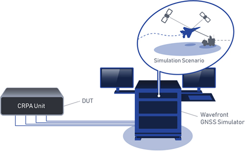
The BroadSim Wavefront Simulator is a new addition to Skydel’s software-defined platform. The BroadSim Wavefront further extends the capabilities achieved by BroadSim Anechoic, incorporating support for controlled radiation pattern antenna (CRPA) and multi-element receiver testing. Powered by Skydel SDX, the simulator’s features include phase-coherent simulation, real-time automated phase calibration, scalability from 4 to 16 elements, and advanced jamming and spoofing scenarios. Talen-X, www.talen-x.com
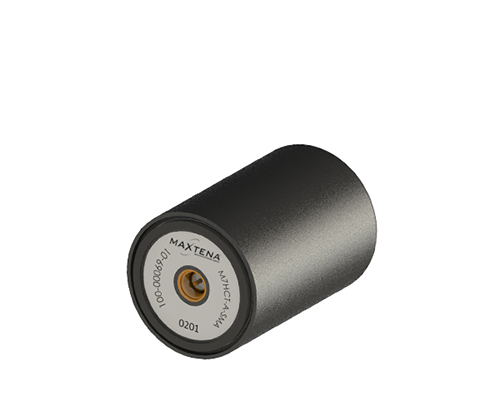
GNSS antenna
For high-precision and autonomous applications
Photo: Maxtena
The M7HCT-A-SMA is a high-accuracy, multi-frequency active quadrifilar helix GNSS antenna designed for high-precision and autonomous multi-frequency applications. The design offers concurrent GNSS reception on L1 (GPS, GLONASS, Galileo, Beidou) and L2 (GPS L2C, Galileo E5B and GLONASS L3OC) in a rugged, compact and ultra lightweight form factor. The antenna is designed for GIS, RTK and other high-accuracy GNSS applications such as the drone and automotive markets. Helicore technology provides exceptional pattern control, polarization purity and high efficiency in a 25-gram form factor. The antenna offers up to 30-dB gain for GNSS applications in one radome housing with a single SMA connector. Maxtena, maxtena.com
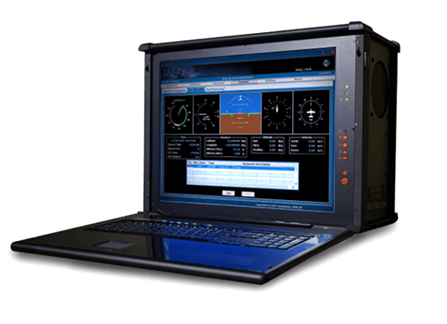
Portable simulation
Solution for field-test requirements
Photo: CAST Navigation
The CAST-1000 duplicates GPS RF signals and uses dual-frequency signal generation technology. This allows for duplicate testing in the laboratory or the field and real-time or configured control. The CAST-1000 is mobile and portable, which makes it the ideal solution for field test requirements. Producing GPS and GLONASS signals with up to 12 satellites in view, the CAST-1000 simulates signals for satellites of P code on L1 and L2 and C/A code on L1. The GPS RF signal is dual-frequency and has a 12-channel configuration for any combination of visible space vehicles. The system is highly programmable — operators can choose from an array of vehicle types and replicate dynamic motion for all kinds of vehicles, from terrestrial to aquatic, airborne to space-based. By utilizing 6-DOF dynamic profile data collected in the field and through profile configuration, a trajectory can be created. The CAST-1000 also features a performance evaluation module, allowing for comparisons between raw and filtered data. CAST Navigation, www.castnav.com
Survey & Mapping
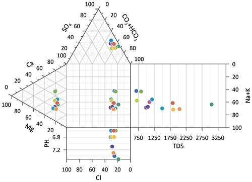
Graphing software
New plotting features
Photo: Golden Software
Version 14 of the Grapher scientific graphing package offers new plotting and customizing functionality based on user feedback. The Grapher software gives users deeper insights into their data by providing them with 80 flexible and easy-to-use 2D and 3D graphing tools for plotting, analyzing and displaying scientific data sets. The package is used extensively by scientists and engineers in oil & gas operations, hydrologic/geochemical studies, environmental consulting, mineral exploration and academic research. New or upgraded features include Enhanced Plotting (the ability to plot data in rows and columns, perform one-button Durov class plots, and easily generate multi-plot reports); and Improved Bar Charts (bar charts are more versatile, offering variable bar widths and differentiated fill colors for negative and positive). Golden Software, www.goldensoftware.com
GIS software update
New lidar functionality
Photo: Blue Marble Geographics
Global Mapper version 20.1 offers new and updated geospatial tools, as well as performance improvements throughout the application. Enhancements to version 20.1 include a new zooming function in the path profile window, a digitizer tool for automatically closing gaps between features and, for lidar module users, a point proximity query function. Blue Marble Geographics, www.bluemarblegeo.com
Survey application
For the geospatial industry
Photo: Global GNSS
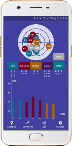
The GNSS Surveyor mobile application provides location information and quality position data in real time with sub-meter to centimeter accuracy. It connects to any external GNSS receiver via Bluetooth. Features include a one-touch configured command to communicate directly with the GNSS Bluetooth device; location information and quality of the position data in real time with centimeter accuracy; GPS data such as position, height, satellites and velocity; and constellation information for GPS, GLONASS, Galileo, BeiDou, QZSS and SBAS satellites. It also includes a direct IP feature for real-time kinematic (RTK) corrections data. An internal NTRIP client loads RTCM data from the internet. Location information is collected as latitude and longitude, altitude, speed or pace, bearing and UTC time. GNSS precision includes global coverage, centimeter-level accuracy, fast time to first fix, multi-constellation and multi-band, and highest security. Navigation uses include ground robotics navigation, lane-level navigation, heavy machine navigation, industrial navigation and tracking, and commercial UAV. Global GNSS, globalgnss.com
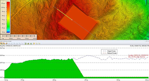
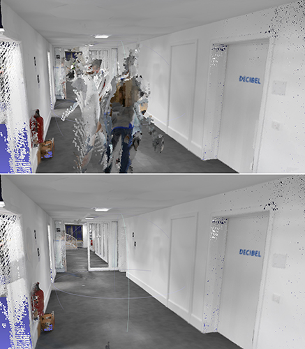
Indoor mapping
Slam technology removes point cloud artifacts
Photo: NavVis
The SLAM-based NavVis M6 Indoor Mobile Mapping System (IMMS) now automatically detects and removes point cloud artifacts, including moving objects in static scenes. The latest IMMS release removes artifacts from point clouds during the post-processing of scan data (see before and after image above). Fringe points and dynamic objects are two common types of point cloud artifacts that affect all 3D laser scanning devices. The NavVis M6 IMMS uses laser scanners to capture a high volume of measurement points of an environment. With the latest software update, the algorithms applied during the post-processing of scan data uses the multiple observations to detect whether measurement points actually exist in the physical space. If it is determined that the point does not exist and is instead resulting from the laser beam hitting an edge or an object moving through the space, this point is automatically removed. The result is a much cleaner, crisper point cloud that requires less clean-up time in point-cloud editing software and that is easier to use for applications such as BIM modeling. NavVis, www.navvis.com
Mobile & UAV
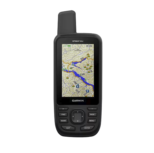
Adventure handhelds
Larger display, improved access to Satellite imagery
Photo: Garmin
Garmin has updated two premium adventure-oriented handhelds, the GPSMAP 66s and the GPSMAP 66st, with expanded wireless connectivity, direct-to-device access to BirdsEye satellite imagery, weather forecasting and a larger 3-inch sunlight-readable color display. The GPSMAP 66st offers preloaded topographic maps for U.S. and Canada, with detail of coastlines, rivers, summits, terrain contours and geographical points. Connectivity to the new Garmin Explore app and the BirdsEye Satellite Imagery (no annual subscription) bring high-resolution photo-realistic route views. Weather updates come via Bluetooth to a compatible mobile device. The Explore app includes features for outdoor navigation, trip planning, mapping and data sharing. Features include multi-GNSS satellite support and altimeter, barometer and compass sensor capabilities; 16 hours of battery life in full GPS mode; LED flashlight and SOS beacon; built to military standards for thermal, shock and water performance (MIL-STD-810G); RINEX data logging that enables sub-meter accuracy of GPS position after post processing. Garmin, garmin.com
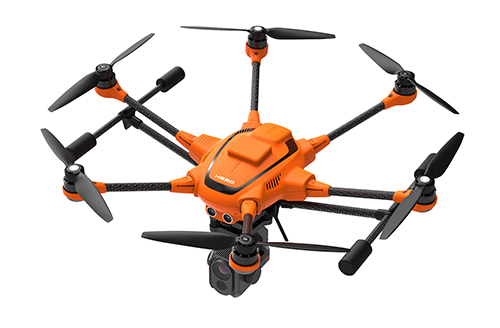
RTK Hexacopter
Integrated GNSS improves accuracy
Photo: Yuneec International
The H520 hexacopter is now available with a real-time kinematic (RTK) system. The fully integrated RTK satellite navigation enables extremely accurate recurring images and faster 3D mapping. It also makes automated inspection flights easier and more precise. The H520 RTK is suitable for commercial applications that require maximum precision. By using RTK technology, the H520 can now fly much closer to objects for inspection because the UAV positions itself precisely in the centimeter range (1 cm + ppm horizontal / 1.5 cm + ppm vertical) rather than in the meter range, which is standard for the H520. Yuneec International, us.yuneec.com
Web-based data service
Enables sharing of UAV data sets
MAGNET Collage Web is a web-based service enabling the sharing and collaboration of UAV and scanning data sets. Version 1.3 allows operators to work with more types of data with greater flexibility, including the ability to import BIM models, as well as CAD and GIS data. It can be used to overlay as-built laser scans and design data to visualize proposed changes and detect construction issues. The software supports OBJ, FBX and 3DS formats. The upgrade also includes new direct publishing functionality for CAD and GIS data files through the browser. Topcon, topconpositioning.com