Global semiconductor company STMicroelectronics has signed an agreement to acquire a majority stake in Swedish silicon carbide (SiC) wafer manufacturer Norstel AB.
After closing the deal, ST will control the entire supply chain for a portion of its SiC devices at a time of constrained global capacity and positions itself for a significant growth opportunity, ST said in a press release.
ST will acquire 55 percent of Norstel’s share capital, with an option to acquire the remaining 45 percent subject to certain conditions, which, if exercised, will result in total consideration of $137.5 million, funded with available cash.
“ST is the only semiconductor company with automotive-grade silicon carbide in mass production today,” said Jean-Marc Chery, president and CEO of STMicroelectronics. “We want to build on our strong momentum in SiC, both in volume and breadth of applications for industrial and automotive, targeting continued leadership in a market estimated at more than $3 billion in 2025.
“The acquisition of a majority stake in Norstel is another step forward strengthening our silicon carbide ecosystem: it will boost our flexibility, improve yield and quality, and support our long-term silicon carbide roadmap and business.”
Norstel, headquartered in Norrkoping, Sweden, was founded in 2005 as a spinoff of Linköping University. It develops and manufactures advanced 150-mm silicon carbide bare and epitaxial wafers.
The latest four Galileo satellites have been given the green light to begin working alongside the rest of Europe’s satellite navigation fleet, giving a further boost to worldwide Galileo service quality.
Galileo has grown to become Europe’s single largest satellite constellation, built up over 10 launches over the course of this decade. The first of seven double-satellite Soyuz launches took place in 2011, with three sets of four-satellite Ariane-5 launches during the last three years.
The latest quartet of Galileo satellites were launched together by Ariane 5 on July 25, bringing the number of satellites in orbit to 26.
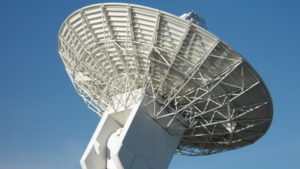
L-band antenna at Redu. (Photo: ESA)
Once safely in orbit the satellites entered their in-orbit test commissioning, overseen by a combination of facilities across Europe.
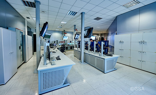
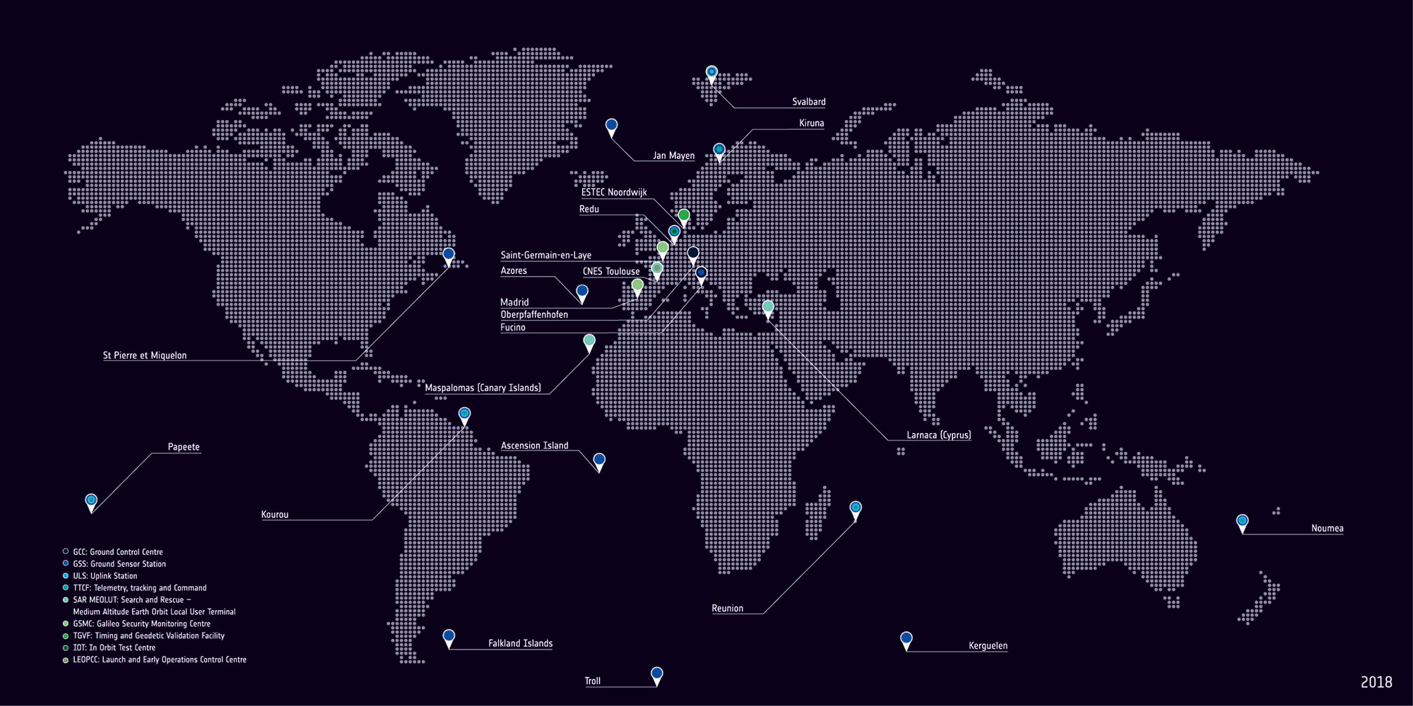
The Launch and Early Operations Phase team of France’s CNES space agency in Toulouse worked together with the two Galileo control centres in Fucino, Italy, and Oberpfaffenhofen, Germany and ESA’s Redu centre in Belgium.
Redu’s 20-m antenna played an important part during in-orbit testing, allowing for high-resolution monitoring of the L-band navigation signal coming from each satellite.
The two control centres participated by testing their control of the satellites. The operations teams confirmed their fully-trained status and their readiness to manage the fleet now it has swelled to 26 satellites in total.
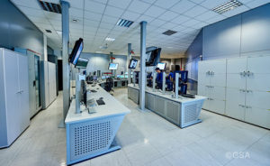
Galileo’s Control Centre in Fucino is used to oversee the satellites’ navigation payloads and services. (Photo: ESA)
David Sanchez-Cabezudo, ESA’s Galileo In-Orbit Testing manager commented: “All the lessons learned and experience gained in these last years through the Galileo satellite commissioning campaigns have led us to a high level of efficiency and effectiveness — not only in managing the technical aspects of the testing operations but the large number of interfaces at contractual and human levels. A complex network of teams has had to work together to make this activity work.”
Galileo satellites orbit in three orbital planes in medium Earth orbit, 23 222 km up. The result is that at least four Galileo satellites should be visible from any point on Earth — the minimum needed to achieve a position fix.
Galileo’s Control Centre in Oberpfaffenhofen in Germany oversees the Galileo satellite platforms. (Photo: ESA)
Oberpfaffenhofen Control Centre
Galileo Initial Services commenced on Dec. 15, 2016, with each new addition to the working constellation serving to enhance the stability and speed of the system.
A further 12 Galileo satellites are currently in production by the same industrial consortium — with OHB manufacturing the satellite platforms and Surrey Satellite Technology Ltd the navigation payloads.
The next Galileo launch is schedule for 2020, the same year that Full Operational Capability is set to start.
The Galileo programme is funded and owned by the EU. The European Commission has the overall responsibility for the programme, managing and overseeing the implementation of all programme activities.
ESA is entrusted with Galileo’s deployment, the design and development of the new generation of systems and the technical development of infrastructure. The definition, development and in-orbit validation phases were carried out by ESA, and co‑funded by ESA and the European Commission.
The European Global Navigation Satellite System Agency (GSA) ensures the uptake and security of Galileo. Galileo operations and provision of services became the responsibility of the GSA in July 2017.
Nearmap high-resolution aerial image of Durham, North Carolina, photographed Jan. 15. (Photo: Nearmap)
Location content provider Nearmap has partnered with the city of Durham, North Carolina, to help it manage infrastructure projects.
The city’s Public Works Department uses Nearmap’s high-resolution imagery to aid in managing all infrastructure data for the city, including the city’s $16 million a year Stormwater Utility Fund.
“Having access to imagery back to 2014, we’re able to go back in time during the thrust of development and monitor it forward,” said Edward Cherry, Durham’s GIS administrator. “With Nearmap, we’ve been able to update development processes and policies to support the revitalization of the downtown district as well as rapid city growth.”
After using satellite imagery systems with low resolution and infrequent captures, Cherry and his staff of 14 GIS professionals determined the city needed superior mapping imagery.
Captured every six months at a 2.8-inch ground sample distance, Nearmap supplies Durham with clear images that are up-to-date and accessible through web-based cloud servers, the company said.
The result is better monitoring of pavement conditions; time savings and documentation of road repairs; more detailed maps of city riparian zones; and accurate and detailed customer billing.
DIRT, the AMW Machine Blade Control Solution. (Photo: AMW)
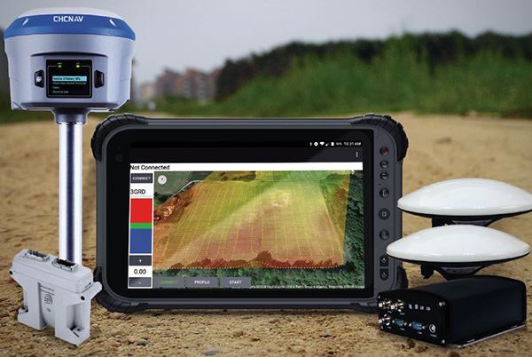
AMW Machine Control Solutions, a subsidiary of CHC Navigation, has introduced four new solutions for the survey, construction and agriculture markets, all of which run on Android and CHC Navigation GNSS tablet hardware.
GRADE I and II Products. GRADE I runs on a CHC Navigation industrial tablet and utilizes an internal meter-accurate GNSS receiver for field workers and supervisors to view layered maps including design files, topo or Google Maps for locating elevations and topographical features.
GRADE II adds centimeter elevation and positioning accuracy with an external CHC Navigation RTK-capable GNSS receiver that wirelessly communicates with the tablet.
GRADE II collects topographic data on the jobsite by walking or driving the area, eliminating surveyor stakes and providing accurate data for earth-moving operations. The density of elevation points can be adjusted. The GRADE II “Smart Base” allows a user to establish RTK control points.
DIRT I and II Products.
DIRT combines GRADE II mapping functionality with automatic blade control for skid steer, scraper, grader or dozer applications for rough and fine land-shaping activities on large or compact equipment. DIRT is available as DIRT I or DIRT II versions depending on the type of blade control needed. Utilizing additional sensors, DIRT II adds the ability to manage cross slopes.
DIRT includes an RTK GNSS, inclinometers, tablet computer, CANBUS controller and DIRT software running on a CHC Navigation tablet. The tablet wirelessly connects to the RTK receiver and other sensors, making the system easily portable so it can be reinstalled on other equipment.
For agriculture applications, AMW Solutions’ proprietary algorithm within the DIRT solution results in accurately graded surfaces within the limits of the equipment.
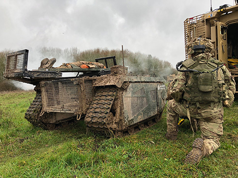
In December 2018 near Salisbury, England, four Milrem Robotics’ and QinetiQ TITAN unmanned ground vehicles (UGVs) were put through three weeks of rigorous tests by British troops during the Army Warfighting Experiment 2018 (AWE18).
The goal was to determine how new unmanned technologies can enhance soldier’s survivability and effectiveness on the modern battlefield.
The modular base can be adapted for various missions, including casualty retrieval. (Photo: Milrem Robotics)
The test was conducted in three phases: conduct combat operations without the benefit of new technologies; conduct combat operations using new technologies but without changing tactics; and, lastly, conduct combat operations using new technologies and adapting tactics according to the capability that the new technology provides.
The UGVs were used in a number of different roles with missions conducted in urban, open and forested terrain.
In remote-control mode, a command-and-control station allows the operator to receive real-time sensor data from the UGV and to transmit command data to the vehicle through a tactical data link. Various third-party sensor packages can be installed.
Of the four Milrem UGVs, two were deployed by Milrem Robotics and two by QinetiQ. The Milrem-fielded systems included one configured as a casualty evacuation and logistical support unit and a second unit equipped with a tethered multi-rotor drone pod provided by Threod Systems.
One of the four UGVs was TITAN Strike, a prototype system carrying a Kongsberg remote weapon station, fully controlled by a remote operator and using QinetiQ’s Pointer system as a means of integrating the capability with dismounted infantry.
The second system, TITAN Sentry, also enabled with Pointer, featured a Hensoldt-provided sensor suite including electro-optical and thermal-imaging cameras and a battlefield radar.
Global UAV Technologies Ltd. has completed a drone-based geothermal energy exploration survey for Borealis GeoPower Inc. The survey used UAV-mounted geophysical and thermal imaging sensors over an area in northern British Columbia, Canada.
Global UAV subsidiary Pioneer Aerial Surveys collaborated with Hummingbird Drones to collect and analyze high-resolution magnetometer and thermal data over the 2,200-hectare survey area.
The survey was conducted using both day and night flight operations to maximize efficiency and data quality. The survey produced high-resolution deliverables on the geological and geothermal features of the survey area.
The work was conducted at the Terrace, British Columbia, geothermal project, near the location of one of the world’s largest hot springs. Borealis is refining its reservoir model in advance of drilling in 2019.
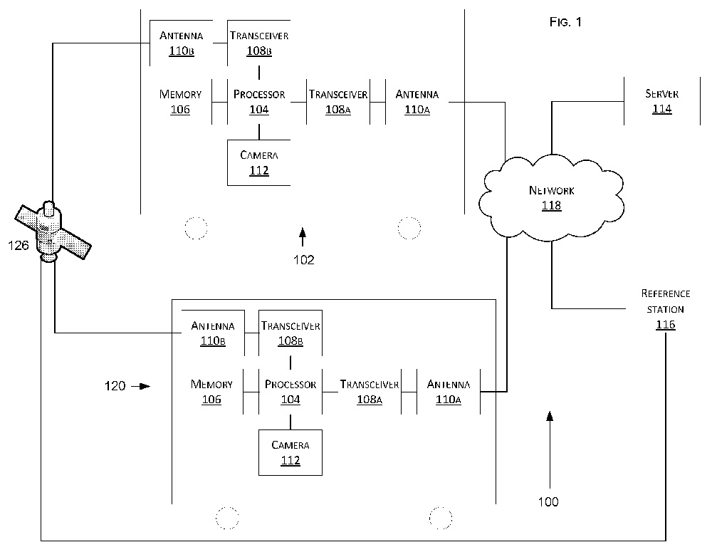
Tesla has developed a technology aimed at providing more accurate positioning for autonomous cars by sharing data between vehicles, according to a U.S. patent application.
The patent, “Technologies for vehicle positioning,” was filed in 2017 and made public in December 2018.
Solutions include cameras detecting matching locations and using other vehicles in its fleet as “cooperative reference stations” to share raw GNSS data and make positioning corrections.
Tesla describes in the patent, “The inventions increase such positioning accuracy via determining and applying offsets (corrections) in various ways, or via sharing of raw positioning data between a plurality of devices, where at least one knows its location sufficiently accurately, for use in differential algorithms.”
Techniques include:
a reference station sharing a positional offset with an automobile,
a reference station calculating and sharing a set of parameters (offsets and corrections) for various error components including atmospheric, orbital and clock,
a reference station sharing its raw GNSS data so that vehicles can remove errors through differencing or other calculations.
Tesla also would correct GPS data by matching camera data with vision maps to detect the exact location of a vehicle. With this vision-map matching localization approach, “a location estimate is varied until the location estimate makes a camera-reported lane boundary coincide with a map-reported lane boundaries,” the patent reads.
Schematic of Tesla’s system shows two vehicles (102, 120) feeding data to a network, a server and a reference station. (Image: Tesla)
InvenSense (TDK Corporation) has introduced a line of automotive high-accuracy devices: the IAM-20680, IAM-20680HP, IAM-20380 and IAM-20381.
According to the company, they are designed to enhance the absolute position of a vehicle in GNSS- and GPS-denied environments.
The IAM-20680 is a 6-axis qualified sensor that features 16-bit accelerometers and 16-bit gyroscopes.
The IAM-20680HP is a high-performance version of the IAM-20680 that features high gyroscope and offset thermal stability.
The IAM-20380 gyroscope is compatible with a 3-axis automotive accelerometer and an automotive-qualified 6-axis device.
The IAM-20381 is a 3-axis accelerometer compatible with a 3-axis automotive gyroscope and an automotive-qualified 6-axis device.
The IAM-20680HP and IAM-20680 can be used to improve estimates of position, direction and speed when GNSS is denied, as well as improve quality of the position estimation when the satellite signal is strong.
Customers can design with the IAM-20680 and can use the IAM-20680HP when navigating in high temperature environments or for systems where cooling is weak or unavailable.
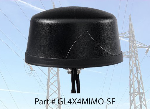
PCTEL Inc. released at DistribuTECH a new dual-band 802.11ac/p MIMO antenna that helps boost data rates and reliability for utility networks, intelligent transportation systems and other industrial IoT (IIoT) applications, according to the company.
PCTEL’s Coach 4×4 Wi-Fi/DSRC GNSS multi-band antenna is designed for both mobile and fixed deployments, enabling smart grids, mobile workforce communications, and advanced automation technologies across a variety of industries.
The antenna also supports Dedicated Short Range Communications (DSRC), a common interoperable safety standard for vehicles.
“PCTEL’s latest antenna will enable the future of the IIoT,” said Rishi Bharadwaj, PCTEL COO. “For example, advanced smart grids utilizing Coach antennas could reduce outages and efficiently manage alternative energy sources.
“Coach antennas also provide mobile connectivity for applications such as DSRC, which has the potential to revolutionize road safety. Those are just some of the possibilities. PCTEL’s advanced RF design and environmental testing capabilities enable us to deliver superior 4×4 MIMO performance and exceptional durability for the most demanding applications,” added Bharadwaj.
This new low-profile antenna features four-port 2.4/5-GHz coverage along with PCTEL’s unique high rejection GPS/GLONASS technology for network timing and tracking, all in a single IP67-rated housing.
It supports a variety of wireless technologies, including broadband mesh networks, 802.11ac Wi-Fi and 802.11p DSRC Wireless Access in Vehicular Networks (WAVE) standards for direct vehicle-to-vehicle (V2V) and vehicle-to-infrastructure (V2I) communications.
This is the latest in PCTEL’s Coach antenna series. Coach antennas have been deployed in a variety of mobile and IIoT applications around the world. Their UV-stable design facilitates maximum installation flexibility without antenna orientation restrictions, the company said.
PCTEL is displaying its Coach4x4 Wi-Fi/DSRC GNSS multi-band antenna Feb. 5-7 at DistribuTECH, booth 11750, in New Orleans. It is available now to order using part #GL4X4MIMO-SF.
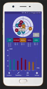
Global GNSS, a subsidiary of Polosoft Technologies, has launched a new mobile application named GNSS Surveyor, which is designed for the geospatial industry.
The application GNSS Surveyor provides location information and quality position data in real-time with sub-meter to centimeter accuracy. It needs to be connected to any external GNSS receiver via Bluetooth.
Features of the application include:
A one-touch configured command to communicate directly with the GNSS Bluetooth device.
Location information and quality of the position data in real-time with centimeter accuracy.
GPS data such as position, height, satellites and velocity.
Constellation information for GPS, GLONASS, Galileo, BeiDou, QZSS and SBAS satellites in the orbit.
Direct IP feature for RTK corrections data.
DMS to DD conversion or vice versa.
Real-time kinematic (RTK) correction data can be forwarded to a high-accuracy external device. The internal NTRIP client loads the RTCM data from the internet.
With GNSS Surveyor, location information is collected as latitude and longitude, altitude, speed or pace, bearing and UTC time.
GNSS precision includes global coverage, centimeter-level accuracy, fast time to first fix, multi-constellation and multi-band, and highest security, the company said.
Navigation uses include ground robotics navigation, lane-level navigation, heavy machine navigation, industrial navigation and tracking and commercial UAV.
The NSDI’s grade rose from a C in the 2015 Report Card to a B- in the 2018 Report Card. The improved overall grades reflect a broadened base of experts and government organizations involved in the assessment, as well as an expanded set of assessment metrics, according to COGO.
The report card uses a letter grading system to depict the status and condition of the nation’s geospatial infrastructure. The assessment measures NSDI’s ability to meet future geospatial data, based on address, cadastral, elevation, geodetic control, government units, hydrography, orthoimagery and transportation themes.
Chart: COGO, from 2018 Report Card.
Objectives of the NSDI include:
reducing the duplication of effort and expense among agencies,
ensuring that geographic data is more accessible to the public,
improving the quality of national data, and
establishing key partnerships within the geospatial field.
“The new report card exemplifies that while progress has been made, federal, state, regional and local government agencies, tribal nations, and private and academic sectors need to continue to collaborate to complete this important work,” said NSGIC President Dan Ross. “NSGIC fully supports that collaboration and will continue to work with our members to support and move this initiative forward.”
COGO member organizations represent leaders in the geospatial field and collectively represent more than 170,000 individual members. Member organizations aim to engage Congress, federal agencies and the FGDC to maintain successful practices and develop improvements and solutions related to the NSDI.
The full 2018 Report Card on the U.S. National Spatial Data Infrastructure, along with the COGO executive summary, video webinar, and presentation slides can be found on the COGO website.
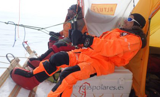
A kite-blown science expedition to the interior of Antarctica has made the most southerly positioning fixes yet made with Europe’s Galileo satellite navigation system.
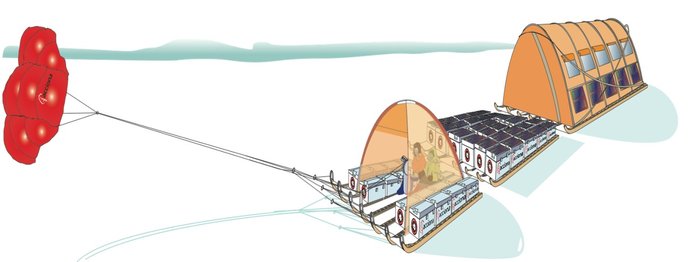
The Inuit WindSled is a multi-part sledge the size of a lorry, complete with mounted tents and solar power panels, pulled through the ice using a mammoth 150 sq. m. diameter kite. (Photo: Inuit WindSled via ESA)
Their measurements not only confirm Galileo performance at extremely high latitudes, but also offer knowledge of space weather events overhead. In particular they offer insights into the ionosphere — the electrically active upper layer of Earth’s atmosphere — above the southern continent, and the performance of Galileo software to correct ionospheric interference.
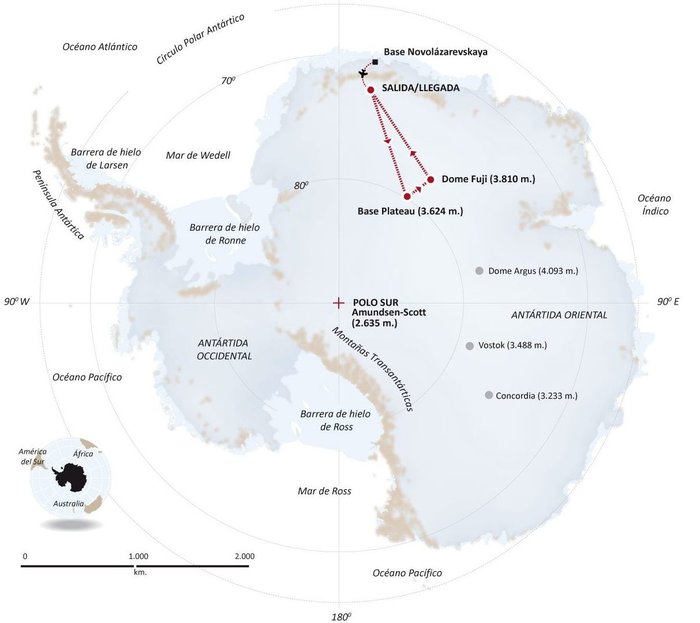
The four-person expedition left Russia’s Novolazarevskaya Base on 12 December last year. For more than 40 days they made their way to Dome Fuji, a 3810-meter-high ice dome in Eastern Antarctica — one of the coldest places on Earth. After reaching the high point on 21 January, they are now back at the Russian base.
The Inuit WindSled is a multi-part sledge the size of a lorry, complete with mounted tents and solar power panels, pulled through the ice using a mammoth 150 sq. m kite. (Graphic: ESA)
The “Antarctica Unexplored 2018-2019″ expedition, mounted by Spain’s Asociación Polar Trineo de Viento, is employing a unique zero-emission vehicle specially designed for polar exploration. The Inuit WindSled is a multi-part sledge the size of a lorry, complete with mounted tents and solar power panels, pulled through the ice using a mammoth 150 sq. m kite.
The Windsled’s inventor, Ramón Larramendi, is also the expedition leader. “This marks the first time we’ve climbed the Fuji Dome in a vehicle driven by the wind — everyone who reached there before relied on motorised vehicles. So this is also the first time we’ve traveled more than 2,400 km with more than 2,000 kg of cargo using a vehicle that does not pollute the Antarctic continent,” Larramendi said.
“We are also doing this in collaboration with ESA, among other scientific institutions, which is very important because it allows us to demonstrate this polar eco-vehicle has excellent possibilities for enabling science in the interior of the Antarctica continent,” Larramendi said.
The four-person “Antarctica Unexplored 2018-2019” expedition left Russia’s Novolazarevskaya Base on Dec. 12, 2018. For more than 40 days they made their way to Dome Fuji, a 3810-meter-high ice dome in Eastern Antarctica — one of the coldest places on Earth. (Graphic: ESA)
The expedition carries a total of 10 scientific experiments from different research institutions, covering fields such as climate change, meteorology and astrobiology. ESA’s involvement with the expedition is the Galileo Experimentation and Scientific Test in Antarctica (GESTA) project.
GESTA involves regular positioning fixes being made over the course of the expedition for all satellite navigation constellations in all kinds of weather and geomagnetic conditions encountered. ESA provided the satnav receiver, with GMV in Spain contributing an advanced signal recorder for data analysis.
One of the important aspects of the study is the monitoring of the ionosphere in such high latitudes during low solar activity. Ionospheric interference can degrade satellite navigation performance, and its incidence is linked to solar activity.
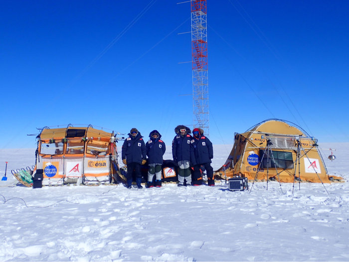
The expedition team with their Inuit WindSled at the high point of Dome Fuji. Note the ESA logo on the left tent of the WindSled. (Photo: Inuit WindSled via ESA)
GESTA is overseen by ESA’s Galileo Navigation Science Office, led by Javier Ventura-Traveset. “We are very pleased with this pilot scientific experience, having been able to collect Galileo measurements all over the expedition trip as planned,” said Ventura-Traveset. “The expedition reached latitudes near 80 degrees south, to our knowledge the most southerly latitude measurements ever-performed in-situ with Galileo in its current near-complete constellation status.
“We have also collected data from all other global satellite navigation systems and all available different frequencies, which will allow us also to assess multi-constellation solutions and compare their performance on these conditions. The expedition team kept in continuous contact via satellite with our office, allowing us to plan their activity, asking, for example, for dedicated data collections during space weather relevant events.”
“Once the expedition data are delivered, we will be able to assess Galileo positioning, navigation and timing capabilities at polar latitudes and how they are influenced by space weather events during low solar activity,” said Manuel Castillo, system engineer at the Galileo Navigation Science Office. “In particular, we will analyze if the occurrence of coronal holes is correlated with observed ionospheric interference. Coronal holes are open areas in the Sun’s outer layer, the corona, that allow the solar wind to leave the Sun and reach Earth, triggering moderate geomagnetic storms.
“At this moment in the 11-year solar cycle, with the Sun close to minimum activity, full-scale solar storms are not frequent, but the ongoing communication between the WindSled team and the Galileo Navigation Support Office allowed us to coordinate measurement times during the three minor geomagnetic storms the expedition experienced during the trip.”
A coronal hole in the Sun, observed by NASA’s Solar Dynamics Observatory on Jan. 5, 2019. (Photo: NASA)
The coronal holes triggering these geomagnetic storms were monitored, meanwhile, by Sun-watching missions such as NASA’s Solar Dynamic Observatory, the NASA-ESA SOHO and ESA’s Proba-2.
ESA’s Galileo Navigation Science Office is based in European Space Astronomy Centre, ESAC, near Madrid. It was set up in 2016 as a joint initiative between ESA’s Science and Navigation Directorates, coordinating scientific opportunities through interaction with the scientific community and the independent GNSS Science Advisory Committee.