Author: GPS World Staff

  • Sharper Shape introduces multi-sensor payload for manned helicopters

    Sharper Shape, a provider of unmanned aerial utility inspection solutions, has released the Heliscope 2.0, an onboard payload system that expands the company’s aerial sensing portfolio into the manned helicopter industry.

    According to the company, the Heliscope 2.0 integrates multiple sensor systems into a single, lightweight helicopter payload, capable of simultaneously collecting a range of data types required for utility maintenance and vegetation management inspections.

    Deployment of the Heliscope 2.0 enables optimized inspection and maintenance schedules, offering potential cost savings in those operational activities by as much as 50 percent.

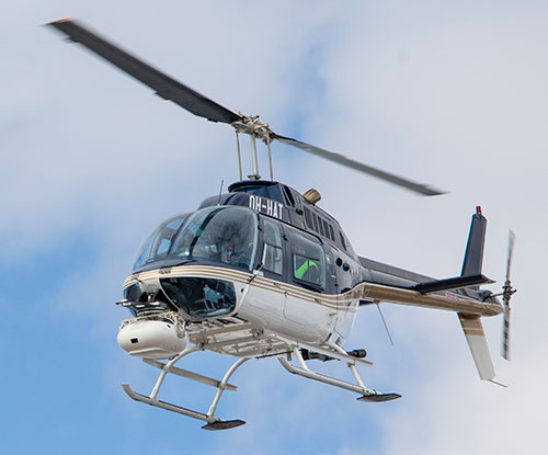
    The Heliscope 2.0 also stands out with its flexible mounting configurations and ability to adapt for mounting on many different helicopter types.

    For example, the system can be mounted on most Bell Jet/Long Ranger helicopters using its FAA-approved nose mount, or attached to numerous other typical helicopter models using its unique Glider aerodynamic sled.

    The U.S. Federal Aviation Administration (FAA) permits mounting the Heliscope 2.0 to helicopters by using the cargo hook found on many helicopter models; this user-friendly method is approved by FAA under a classification for gliders.

    “While drones are a very flexible and safe method for performing utility inspections, there are situations where manned helicopters are the preferred vehicle to host sensors during certain utility inspections,” said Mikko Saarisalo, Sharper Shape’s vice president of drones and project lead for the Heliscope 2.0 project. “The new Heliscope 2.0 provides a solution for those situations where we need to operate over greater distances or in harsher environments than the drones can easily accommodate. This system takes our data harvesting efficiency and productivity up to a level unprecedented in the industry.”

    CORE includes algorithms to automatically analyze lidar point clouds and quickly generate utility vegetation management reports. Further, its unique automatic issue detection (AID) machine vision software uses artificial intelligence (AI) to eliminate the daunting task of performing frame-by-frame image data inspection, allowing personnel to focus on other aspects of inspection compliance.

    CORE applications work equally well with either Sharper Shape’s proven unmanned aerial inspection services, or with the new Heliscope 2.0 manned aircraft solution.

    “The fact that the Heliscope 2.0 integrates fully with our CORE software suite is a huge benefit,” said Sharper Shape CEO Ilkka Hiidenheimo. “We can collect all the key inspection assets and measurements in one high-speed pass, and then easily pass these files to our CORE suite for automatic processing. Sharper Shape is the only company on the market that offers this range of options for collecting aerial data and for processing this data automatically into a wide range of digital report formats.”

    The Heliscope 2.0 system is now available for immediate contract services in the U.S., South America and Europe.

  • DroneUp launches program for UAV pilot training, certification

    DroneUp is collaborating with industry leaders and government officials to promote the desired outcomes of the Federal Aviation Administration (FAA), public safety personnel, and the unmanned systems community by announcing the Responsible Community Pilot (RCP) program.

    DroneUp is a drone pilot community focused on safer skies through continuous education and sense of purpose. The announcement was made at the AUVSI Xponential show being held this week in Denver.

    The mass proliferation of small unmanned aerial systems (sUAS), specifically those operated by non-commercial pilots, has created nearly unparalleled policy, safety and legislative issues.

    To remove confusion and help increase resources available to all pilots, DroneUp is partnering with the International Association of Community Drone Pilots (IACDP) to provide tools and resources to meet the real objectives of improving airspace safety.

    By providing free access to a community-based set of guidelines and programming, the RCP program engages drone pilots through training, certification, idea-sharing and community.

    DroneUp provides the means and connections with the community to help pilots operate in the national airspace. Some of those free tools include:

    • Continually updated online courses and exams that improve regulation awareness
    • Mission-driven experiential exercises that improve piloting skills
    • An online community for questions and discussion
    • Mobile apps that verify where it is safe to fly and active advisories nearby
    • Comprehensive Standards of Conduct
    • Detailed Safety Guidelines
    • Advocacy on behalf of the community

    “Our efforts to build this community through training and a sense of purpose are having dramatic positive effects on ensuring air safety,” said Tom Walker, Founder and CEO, DroneUp. “We are dedicated to not only continuing our efforts, but to sharing collected data that will prove invaluable to officials as they draft future policies.”

    In advocating for both commercial and non-commercial use of small unmanned aircraft systems, IACDP represents commercial, recreational, military and public safety pilots.

    “IACDP is motivated by a desire to make a positive impact on the industry,” said IACDP President John Evans. “We are still growing and expanding our training, certification, and advocacy resources. We see organizations like DroneUp as valuable strategic partners for our mission.”

    To date, more than 20,000 non-commercial sUAS pilots are active members of DroneUp’s RCP community. Through affiliations with its non-profit partners, this number is expected to increase to more than 100,000 sUAS pilots over the next six months.

    Membership in DroneUp’s RCP program requires successful annual completion of the RCP training and examination online.

    Upon completion of the certification, RCP participants will receive a certificate with a unique ID number, an RCP badge in DroneUp’s mobile app; they also may request a personalized RCP ID Badge.

  • Hexagon offers intelligent cultivation management for agriculture

    Hexagon, a global provider of information technology solutions, has launched HxGN AgrOn Production, an integrated cultivation management solution that empowers customers to optimize resource efficiency, increase yield, reduce inputs and ensure quality.

    The solution is comprised of software and hardware solutions that optimize and automate entire crop cycles from planning to cultivation.

    Hexagon officially revealed HxGN AgrOn Production today at Agrishow, one of the world’s largest agricultural technology fairs in the world taking place in Ribeirão Preto, Brazil.

    “Real-time information is the key to efficient field management. HxGN AgrOn Production brings immediate benefits to agricultural and forestry companies — providing instant control of all stages of the cultivation process and enabling resource optimisation and efficiency,” said Ola Rollén, president and CEO of Hexagon.

    According to the company, the solution will enable Hexagon’s customers to achieve a smarter cultivation by connecting, synchronizing and optimizing workflows, teams and information while reducing operating costs.

    HxGN AgrOn Production addresses resource management challenges of enterprise farms and is a future-proof investment in information technology innovations that are enabling the smart digital reality in agriculture.

  • 3DR launches ground control point app for drones

    3DR, makers of the Site Scan drone software platform for construction and engineering professionals, has released 3DR GCP, an Android app enabled by the Trimble Catalyst on-demand GNSS service that makes it simpler for Site Scan users to capture and use ground control points (GCPs) on commercial drone projects.

    Now, instead of having to export ground-control-point data files and manually upload them into Site Scan, 3DR customers can use 3DR GCP to quickly capture ground control points and automatically transfer them to their corresponding projects in the Site Scan cloud for georeferencing and processing. According to the company, this makes it easy for any Site Scan user to create accurate drone maps and models of their projects.

    3DR GCP is enabled by Trimble Catalyst, a software-defined GNSS receiver and on-demand positioning service for Android phones and tablets. Developed by Trimble, the service uses a small, lightweight, plug-and-play digital antenna to deliver high-quality satellite data to the 3DR GCP app running on the user’s Android device.

    The service is available as a monthly subscription, which unlocks a range of precision levels from meter to only a few centimeters. Customers simply go on-site, plug the Catalyst DA1 antenna into their Android device, launch 3DR GCP, and capture ground control points at the level of accuracy enabled by their Catalyst subscription.

    “3DR GCP provides our customers an end-to-end, cloud-based ground control point workflow from the field to the office,” said Chris Anderson, CEO of 3DR. “With this app, we’ve closed the loop on ground control points by making one simple, connected workflow from start to finish.”

    “Trimble is excited for 3DR to join our ecosystem with the launch of 3DR GCP,” said Gareth Gibson, business development manager for Trimble Catalyst. “With this innovative ground control app, 3DR is making it easier than ever for their customers across the world to create accurate, reliable drone maps and models and better capture their projects.”

    3DR GCP can be purchased along with Site Scan subscriptions, and will require a Trimble DA1 antenna and Catalyst subscription.

  • Talen-X developing Modernized Navstar Security Algorithm

    Talen-X developing Modernized Navstar Security Algorithm

    Image: Talen-X
    Image: Talen-X

    For several months, Talen-X engineers have been working with the proper channels to develop MNSA (Modernized Navstar Security Algorithm). Talen-X is designing the implementation of MNSA for its flagship products: BroadSim and BroadSim Anechoic.

    BroadSim is a software-defined GNSS simulator made to accomodate engineers who test systems requiring encrypted signals, jamming and spoofing. According to the company, BroadSim Anechoic leverages the same software-defined capabilities, scaled to enable powerful anechoic chamber simulations.

    Encrypted signal simulation is being used to support many military testing applications, both in the lab and in the field. BroadSim can simulate many signals including the legacy GPS Y-Code and the modernized GPS Advanced Encryption Standard (AES) M-Code, the company said.

    Other companies use costly and outdated field programmable gate arrays (FPGAs) to upgrade their systems. With Talen-X, users can opt for a simple license upgrade to enable the new GNSS signals to include GPS AES M-Code and eventually MNSA on their BroadSim device.

    With the addition of MNSA, engineers testing capabilities will reach the closest they’ve ever been to simulating real-world scenarios, ensuring complete confidence in the accuracy and resiliency of the test unit.

  • u-blox high-precision GNSS module based on its F9 technology

    u-blox, a global provider of leading positioning and wireless communication technologies, has released the ZED-F9P multi-band GNSS module with integrated multi-band real-time kinematics (RTK) technology for machine control, ground robotic vehicles and high-precision unmanned aerial vehicles (UAV) applications.

    The ZED‑F9P measures 22 x 17 x 2.4 millimeters and uses technology from the recently announced u‑blox F9 platform to deliver robust high-precision positioning performance in seconds.

    The u-blox ZED-F9P is a mass market multi-band receiver that concurrently uses GNSS signals from all four GNSS constellations (GPS, GLONASS, Galileo and BeiDou). Combining GNSS signals from multiple frequency bands (L1/L2/L5) and RTK technology lets the ZED‑F9P achieve centimeter-level accuracy in seconds, the company said.

    Receiving more satellite signals at any given time maximizes the availability of centimeter-level accuracy even in challenging environments such as in cities.

    With its high update rate, the ZED‑F9P is suitable for highly dynamic applications such as UAVs. Featuring on-chip integration of advanced multi-band RTK algorithms, it requires no additional hardware or third-party RTK libraries. Ready to use on delivery and easy to integrate, it helps product developers quickly bring their ideas to the market.

    ZED-F9P is fully geared to clearing the three main hurdles that have kept centimeter-level positioning accuracy from breaking into mass-market applications: cost, size and power consumption. Significantly smaller and more energy efficient than existing solutions, and as a cost efficient alternative, the ZED-F9P will enable new high-precision positioning applications for the mass market.

    “The new ZED-F9P GNSS receiver builds on the success of our NEO-M8P high-precision GNSS module, but takes performance to another level by leveraging all the available GNSS signals,” said Mårten Ström, senior principal product management, product center positioning at u‑blox. “By making robust and affordable high-precision positioning technology more accessible, we hope to fuel innovation and enable a new generation of high-precision GNSS navigation applications.”

    Engineering samples will be available at the end of July.

  • Satellites Leadership Award presented to Wolfgang Paetsch

    For his leadership in setting up the routine production of the Galileo satellites leading to Galileo constellation deployment, including thequadruple Ariane 5 launch in November 2016, Wolfgang Paetsch was named the winner of the 2017 Satellites Leadership Award. Since he was unable to attend, Paul Verhoef, director of the Galileo Programme, accepted the award on his behalf at the GPS World Leadership Awards dinner. The award was presented by Rob Scott from Rockwell Collins, a co-sponsor of GPS World’s Leadership Dinner and Awards Ceremony.

  • NavVis launches Autodesk Revit add-in for BIM models

    NavVis, a global leader in mobile indoor mapping, visualization, and navigation, announces a new add-in for Autodesk Revit.

    The add-in lets Revit users connect their BIM models to 360-degree immersive imagery and point clouds captured by the NavVis mobile mapping system. The add-in simplifies the process of creating and updating outdated BIM models to reflect the current state of the building.

    NavVis technology is an all-in-one reality capture solution that has made it possible to quickly scan the current state of large industrial and commercial properties and stream the data on any device.

    The data is captured by the NavVis M6 mobile mapping system, an innovative mobile mapping system that can scan indoor environments at the speed of walking. The data is then visualized in the NavVis IndoorViewer, which is browser-based software that streams the immersive panoramic images and point clouds.

    With the Revit add-in, the NavVis IndoorViewer can now easily be integrated with Revit BIM models. Integrating Revit and IndoorViewer allows for a side-by-side comparison of the BIM model and the scanned state of the building, remotely from a desktop. This lets users quickly spot the changes that have been made since the model was created and the current state was captured, helping to speed up the process of updating BIM models. Integrating BIM and IndoorViewer also overcomes data silos and reduces planning errors that occur as a result of outdated information.

    Revit users who install the add-in will be able to access the added value of the NavVis IndoorViewer, which includes adding and searching for information and mark-ups, taking measurements, route finding and online collaboration with stakeholders.

    NavVis IndoorViewer Add-In visualizes buildings in Autodesk Revit.
    NavVis IndoorViewer Add-In visualizes buildings in Autodesk Revit.
  • Esri to donate software to in-need nations for census work


    Through the new Esri Official Statistics Modernization Program, the company will donate perpetual use licenses for ArcGIS software to eligible official statistical agencies in least developed countries (LDCs) and small island developing states (SIDS).

    The program provides access to Esri ArcGIS Enterprise technology in support of the upcoming census counts that all countries will undertake during the Census, 2020 Round.

    The data collected as part of these census counts is crucial to nations for competing on the global stage. By using authoritative methods of collection and the cutting-edge mapping and analytics tools that Esri is donating, developing nations can gain an advantage in making data-driven policy decisions suited to a globalized economy.

    The Esri Official Statistics Modernization Program provides access to the same software that hundreds of thousands of Esri customers—from public agencies to private enterprises—rely on every day to run their organizations. Esri will also provide guidance and best practices workflows at no cost so countries can implement their own systems to help with collecting data for their census.

    “Population and housing censuses are big efforts for countries, especially those that may not have the resources readily available,” said Linda Peters, Esri global business development manager. “These censuses are important, as the data collected is one of the primary sources of information needed for formulating, implementing, and monitoring policies aimed at inclusive socioeconomic development and sustainability.”

    Modernization efforts around census activities are helping countries leapfrog from paper-based workflows to digital and mobile ones. The United Nations (UN) expert group that specifically focuses on integrating statistical and geospatial information advised all countries to use a Global Statistical Geospatial Framework (GSGF) to aid in the modernization program.

    This framework requires nations using GIS technology like Esri’s to ensure the implementation of up-to-date capabilities like data accessibility, ease of use of the technology, and the conversion of addresses into geographic coordinates on maps (geocoding).

    The Esri Official Statistics Modernization Program was announced at the GIS for a Sustainable World conference in Geneva, Switzerland, co-organized by Esri and the UN. For more information on the program and nation eligibility, visit go.esri.com/officialstatisticsprogram.

  • AUVSI Xponential preview: IMUs key to UAV imaging advances

    AUVSI Xponential preview: IMUs key to UAV imaging advances

    Phoenix Lidar’s Scout System features NovAtel SPAN GNSS/IMU equipment and a pinwheel antenna. Combined with Phoenix’s hardware and software, this lightweight UAV lidar system serves in agriculture, construction and other general mapping applications. Here the Scout is integrated with the DJI M600 Pro UAV. (Photo: Phoenix Lidar Systems)

    As a UAV flies, it is subject to roll, pitch and yaw movements, adversely affecting the high-definition imagery that industrial-grade UAVs are designed to collect. Three measures combat unwanted movement: a stabilizing gimbal, a high-quality GPS/inertial measurement unit (IMU) integration, and orthorectification of the data during post-processing.

    Imaging applications are driving all sectors of the booming UAV market. The increasing availability and variety of compact, robust, lightweight sensors, employing a range of super-resolution and often multi-spectral and hyperspectral technologies, continuously expand and improve UAV applications.

    Three companies exhibiting at the Association for Unmanned Vehicle Systems International’s (AUVSI’s) massive Xponential show May 1-3 will showcase recent advances in this arena.

    Challenges of Airborne Imaging. Size and weight govern UAV deployment.Imaging sensors must fit compact payload bays. An integrated UAV solution will typically include an imaging sensor, a high-performance GPS/inertial measurement unit (IMU), and a data storage hub to collate streams of data from all connected instruments.

    Software geared specifically to flight supplies image orthorectification and manages sensor operation during the mission, enabling users to input GPS coordinates for sensor operation. Outside of defined coordinates, the sensor will not collect data, reducing the amount of data to store or transmit.

    Immediate or real-time processing and georeferencing of imaging products has always been key to defense and security applications; it becomes critical for precision agriculture, cartography, civil engineering, remote monitoring and surveillance, intelligent inspection, disaster preparedness and risk study, newsgathering, cinematography, tourism and even commercial advertising. A multisensor landscape view can improve a UAV’s ability to react intelligently without operator input.

    Integrated GPS/INS exhibitors at the Xponential show include:

    NovAtel (Booth 3219). The company uses a flexible technology platform and diverse OEM products, which include SPAN technology: tightly coupled GNSS receivers with IMUs for reliable, continuously available, position, velocity and attitude, to deliver its vision of assured positioning — anywhere.

    NovAtel offers TerraStar Correction Services to provide accurate real-time sub-meter or decimeter positioning around the world, anytime. Its Waypoint Inertial Explorer Xpress post-processing software provides the same core processing and utilities as Inertial Explorer along with simplified functions and workflows tailored for UAV markets and small project areas.

    VectorNav (Booth 2214). Engineers at Octopus ISR integrated the VectorNav VN-200 GPS/INS directly into the optical bench of a gimbal to deliver positioning accuracy under flight conditions such as high vibrations, accelerations and temperature fluctuations. The device flies aboard the UAV Factory’s miniature Epsilon series of gyro-stabilized gimbals, enabling the Precision Geo-Lock feature, which combines a GPS-aided inertial navigation system with dedicated software algorithms and payload operator software.

    The VN-200 features 16g accelerometers and 2000°/sec gyros in a postage-stamp-sized surface-mount device and a rugged package. Epsilon gyro-stabilized turrets are available with both VectorNav’s VN-200 single GPS-based INS solution and the VN-300 dual GPS-based INS.

    SBG Systems (Booth 2535). The company developed specific calibration procedures to provide reliable heading even when UAVs tilt. Magnetometer calibration can be processed in 2D on the ground, or in 3D in flight. Qinertia software enhances inertial navigation systems performance by post processing inertial data with raw GNSS observables.

    SBG Systems’ Ellipse 2 Micro high-performance inertial sensors reduces size and costs and for volume projects. It is available as an inertial measurement unit (IMU), or as an attitude and heading reference system (AHRS) or inertial navigation system (INS) running an extended Kalman filter, connected to an external GNSS receiver.

  • Septentrio launches AsteRx SB compact, ruggedized GNSS receiver

    Septentrio launches AsteRx SB compact, ruggedized GNSS receiver

    Photo: Septentrio
    Photo: Septentrio

    GNSS receiver manufacturer Septentrio is introducing its AsteRx SB at two industry shows: Expomin in Santiago, Chile (April 23-27), and Intermat in Paris, France.

    According to the company, the AsteRx SB delivers Septentrio’s quad-constellation real-time kinematic (RTK) positioning in a low-power, IP68 compliant housing. Built around the AsteRx-m2 GNSS receiver engine, the AsteRx SB features Wi-Fi, Bluetooth, USB, Ethernet and serial connectivity.

    Septentrio’s GNSS+ suite of positioning algorithms converts difficult environments into good positioning: LOCK+ technology to maintain tracking during heavy vibration, APME+ to combat multipath, and IONO+ technology to ensure position accuracy during periods of elevated ionospheric activity.

    The AsteRx SB also features the AIM+ interference mitigation and monitoring system, which can suppress the widest variety of interferers, from simple continuous narrowband signals to the most complex wideband and pulsed jammers.


    Key benefits for users:

    • Quad-constellation, multi-frequency, all-in-view RTK receiver
    • Robust and compact IP68 weatherproof housing
    • AIM+ interference monitoring and mitigation system
    • L-band PPP, RTK, scalable accuracy
    • High-update rate, low-latency positioning
    • Base and rover operation
    • Bluetooth, Wi-Fi, Ethernet, serial and USB communications

    Whether exposed to the elements or inside a vehicle cab, operating alone or as a core component of a sensor-fusion system, the AsteRx SB is straight-forward to set up and integrate into any new or existing application. Using Wi-Fi or micro USB, the AsteRx SB can be configured and monitored using any device with a web browser.


    “We believe the AsteRx SB is the best all-rounder on the market today. We’ve produced a small and low-power device with zero compromise on performance,” said Gustavo Lopez, product manager at Septentrio. “From machine control to sensor-fusion applications, manned or unmanned, the compact size and low power of the AsteRx SB along with its range of communications options make it ideal for any project requiring reliable high-precision positioning.”

    At Intermat in Paris, Septentrio will exhibit at Booth 6H-041 and at Expomin in Santiago, Chile, at Booth 1K-30.

  • Trimble launches TSC7 controller and apps for surveyors

    Trimble has released the Trimble TSC7 controller, a new field solution for land and civil construction surveyors. The TSC7 brings powerful enhancements to the field and was designed based on customer feedback, the company said. It provides a tablet experience with a physical keyboard and a sunlight readable 7-inch touchscreen that supports pinch, tap and slide gestures.

    Users can interact with the TSC7 intuitively, easily zooming, panning and selecting items on the large touchscreen. Front- and rear-facing cameras allow users to video conference their office from the field for on-the-job support, and capture high-definition videos and images that provide valuable context to their data and clients.

    Trimble TSC7 controller.

    The TSC7 also leverages the power of Windows 10 Professional, driven by an Intel Pentium 64-bit quad-core processor. The processor and operating system make it easy to process data in spreadsheets and run office software programs. An ergonomic form factor, IP68-certified rugged design and optional, user-interchangeable modules make the TSC7 a flexible solution for all surveying applications.

    Trimble also announced a new version of its field software, Trimble Access 2018. The software features a new user interface and powerful graphics capabilities to deliver enhanced workflows for field surveyors.

    Access 2018 has been redesigned with even more intuitive menus and screen navigation to take advantage of the TSC7’s 7-inch touchscreen and computing power, while leveraging software workflows, which include applications for general survey, roading, tunnels and pipelines.

    Access 2018 also integrates with the Trimble Sync Manager application to enable cloud-based data management between the office and the field. Surveyors can quickly start working by downloading preconfigured jobs in the field with DXF maps and CSV files linked ready to start surveying. Sync Manager also integrates seamlessly with Trimble Business Center software and is compatible with other industry office software platforms.

    https://youtu.be/I2oMLIvu3Ck

    “Today’s surveyors are managers of geospatial intelligence,” said Ron Bisio, vice president of Trimble Geospatial. “Data has more depth and complexity than ever before, and surveyors’ reputations depend on transforming that data into valuable, reliable information for their clients. The TSC7 and Access 2018 form the new backbone of our field solutions ecosystem, and give our users a leading edge to be data experts.”

    Rover Systems

    Trimble is also releasing two new rover systems for civil engineering and construction applications — the Trimble Siteworks Positioning System for Construction Surveyors and the Trimble Siteworks Positioning System for Supervisors.

    Both systems feature new Siteworks Software, next-generation survey software tailored for construction workflows. Completely redesigned from the ground up, Siteworks Software features a new interface that is optimized for ease-of-use and productivity. Configurable views, colorful graphics and natural interactions and gestures make Siteworks software intuitive and easy to learn.

    Siteworks Positioning System for Construction Surveyors is comprised of the Trimble SPS986 GNSS smart antenna, the TSC7 controller and Siteworks software. It enables construction surveyors to work with complex 3D models, collect large data sets faster, visualize complex 3D models more easily and work day or night efficiently.

    Siteworks Positioning System for Supervisors is comprised of the SPS986 GNSS smart antenna, the Trimble T10 Tablet and Siteworks software. It enables construction supervisors to run full office software packages, including Business Center – HCE and Microsoft Office, and to work easily with data and 3D models in the field without carrying a laptop.

    The Trimble TSC7 Controller running the current version of Trimble Access field software will be available worldwide in May through Trimble’s Geospatial distribution partners.

    The Access 2018 beta program will open to applicants in early May.