SenseFly is partnering with Trimble to optimize the drone mapping workflow for geospatial professionals.
The new integration is designed to ensure a smooth end-to-end mapping drone workflow. senseFly operators can now, within the recently launched eMotion 3.5 software, transform a senseFly S.O.D.A. camera’s georeferenced imagery into an automatically collated project (in .jxl format).
This enables the one-click import of drone imagery into the Trimble Business Center Aerial Photogrammetry module without the need for manual project creation and organization of images.
The senseFly-to-Trimble mapping workflow includes:
planning and monitoring a senseFly S.O.D.A.-based drone flight (in eMotion 3.5)
downloading the drone’s images for one-click georeferencing in eMotion 3.5 (Flight Data Manager)
clicking to create a .jxl format mapping project
opening a project within the Trimble Business Center Aerial Photogrammetry module
processing the drone’s imagery to generate orthophotos, contour maps, point clouds, digital surface models (DSMs) and feature maps
analyzing and acting upon the data.
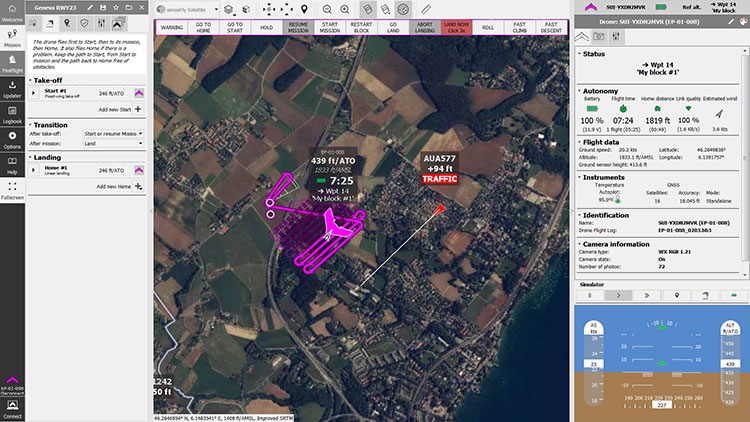
Screenshot: Trimble
“Making work easier and more efficient for geospatial professionals is the goal that drives every solution we develop,” said Jean-Christophe Zufferey, senseFly co-founder and CEO. “Therefore, we are excited to collaborate with Trimble on more tightly integrating our solutions, since enhancements such as this new eMotion-to-Trimble Business Center workflow do exactly that, ensuring that the transition from data collection to acting upon this data is as seamless as possible.”
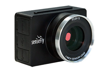
The senseFly S.O.D.A. is built for professional drone photogrammetry work. The 1-inch, 20-megapixel RGB camera captures sharp aerial images across a range of light conditions, allowing senseFly fixed-wing drone operators to produce detailed, vivid orthomosaics and ultra-accurate 3D digital surface models.
senseFly S.O.D.A. is compatible with most senseFly fixed-wing mapping drones, including the large-coverage eBee Plus.
Trimble Business Center allows surveyors and other geospatial professionals to combine aerial photography with data collected from GNSS receivers, total stations, 3D laser scanners and more, for a complete field-to-finish workflow. By combining imagery from unmanned aerial systems with ground-based survey data, users can visualize their project from both aerial and terrestrial perspectives, measure points within the images and create 3D models of the infrastructure and terrain.
The workshop is part of the official Arctic Council calendar (Finland is the chairman for 2017-2019). It will gather academia, industry and authorities to discuss navigation challenges on land, air and sea in the Arctic.
The experts will be looking for solutions and the next steps forward. One challenge is solving the problem of suboptimal satellite navigation augmentation constellations in the Arctic, as well as scintillation affecting satellite navigation.
The workshop is funded by the Finnish Ministry of Foreign Affairs and organized by the Finnish Ministry of Transport and Communications, but they have delegated the arrangements to FGI/Department of Navigation and Positioning.
Speakers and participants from all Arctic Council states will take part, with participation expected to be around 100-150.
The event is free of charge, but participants will have to cover their own travel and accommodation expenses.
Olos is close to the snowtonomous ITS testing grounds Aurora Snowbox, and participants will also be given information and a demonstration about the site during the workshop.
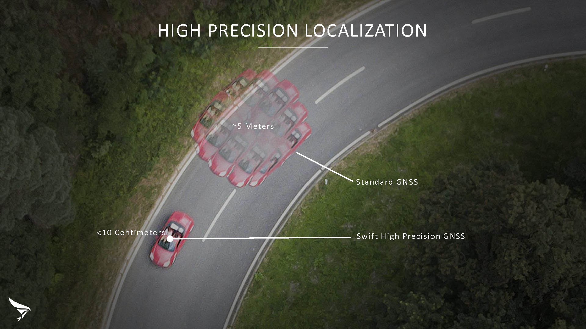
Swift Navigation has released Skylark, a cloud-based GNSS corrections service delivering centimeter-level accuracy without deploying and maintaining a GNSS network. Skylark targets autonomy applications at scale and enables high-precision positioning for mass market automotive and autonomous vehicle applications.
Skylark works with both of Swift’s multi-band, multi-constellation GNSS receivers, the Piksi Multi and the Duro ruggedized industrial receiver. Swift added GLONASS support in its 1.4 firmware upgrade, announced earlier this month, and aims to include Galileo and BeiDou in the near future.
Previously known as a hardware company, Swift Navigation appears to be shifting its focus a bit, including an Internet-delivered service in addition to its GNSS receivers. It has recently focused more closely on the automotive sector; it also has customers in drone technology, robotics and precision agriculture.
Its new platform for high-precision GNSS navigation of autonomous vehicles, via Internet connectivity, Skylark delivers fast convergence times measured in seconds, using positioning algorithms to provide a continuous stream of data to individual devices from the cloud. The data stream allows for quick and robust positioning and high reliability and availability, even in challenging environments, according to the company.
The Skylark service offers accuracy at the centimeter level. (Image: Swift Navigation)
Critical requirements for real-time absolute localization through GNSS for the automotive sector, according to Fergus Noble, co-founder and CTO of Swift Navigation, are:
high accuracy; centimeter level
availability; fast convergence, measured in seconds
integrity
scalability to support a large vehicle population
low cost.
Internet-Delivered via Cell Network
The last two requirements are fulfilled by the cloud-based approach. He characterized Skylark as a hybrid of RTK (Real Time Kinematics) and PPP (Precise Point Positioning) approaches augmented by Swift’s intellectual property, with corrections delivered over the Internet as provided by the cellular network, which he described as “robust to outages.” Cell coverage along road networks is good, Noble asserted, and 5G applications are increasing that coverage and will further enable connected vehicles. Automotive OEMs are comfortable with the level of cell coverage for this application, according to him. There has been testing to show robustness in most rural areas, and network operators are dedicated to increasing this.
“Skylark operates like a utility,” said Noble. “It is a simple, low-cost Internet data stream that provides customers with a complete high-integrity GNSS solution. Simply supply a Swift receiver with power and Internet connectivity and get real-time corrections for highly-dynamic GNSS applications.”
To realize the Skylark service, the company hired a team of cloud-based engineering experts who had a role in building Amazon and Oracle critical infrastructure. Swift Navigation is initially launching only with its own devices, but is making the service publicly-available for any customer in any vertical requiring precise positioning. “Every car company is building in autonomous functionality,” noted Noble, making clear who the company is ultimately targeting.
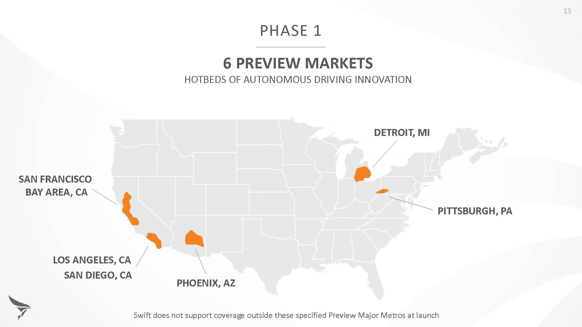
Skylark is currently offered in six metropolitan markets. (Image: Swift Navigation)
Swift has been working with beta customers for more than a year and is now previewing the service to all customers in six metropolitan markets: the San Francisco Bay Area, Los Angeles, San Diego, Phoenix, Pittsburgh and Detroit. The company envisions full contiguous U.S. and ultimately global expansion. Customers in preview areas with Swift receivers can sign up for Skylark and immediately start receiving corrections.
The service maintains low bandwidth to save on data costs and is offered with a free 30 day trial and flexible pricing plans. Skylark’s pricing structure includes a monthly plan and an annual plan. Enterprise pricing is available for volume orders.
Voyage Self-Driving Car Active Service and Coming Expansion
An early beta user of the service, Voyage deploys self-driving taxis in private communities across North America. “Skylark and Piksi Multi are working safely and efficiently in a real-world application today at The Villages, a retirement community in San Jose, California,” said Oliver Cameron, co-founder & CEO of Voyage.
Voyage incorporates Skylark GNSS corrections in controlled road networks in private communities. (Image: Swift Navigation)
Voyage’s passenger cars carry a roof-racked suite of sensors: the Swift Navigation Piksi Multi GNSS receiver, LiDAR, cameras, radar, and an inertial measurement unit. A computer in the trunk integrates all sensor signals and uses the car’s CAN bus to operate steering, braking, and other functions. An operator sits behind the wheel at all times, sometimes with a co-pilot: one to watch the road ahead, and one to watch the software. “Safety is our first priority,” said Cameron.
The service is especially valuable to customers with mobility limitations that might prevent them from walking to an event or moving within the community. (Image: Swift Navigation)
The Voyage fleet stays within the bounds of a given community, where all roads have been precisely mapped, speed limits are lower and traffic patterns are more clearly defined than in metropolitan cities. The first in the San Jose area serves private community of more than 4,000 residents, with a 15-mile road network. Today, residents are able to summon a Voyage self-driving taxi using a smartphone app and have a ride waiting at their front door. This service is especially valuable to customers with mobility limitations that might prevent them from walking to an event or moving within the community. Voyage takes residents of The Villages to and from the gym, to visit with friends, to the golf course and to community center events.
Image: Swift Navigation
Voyage will next deploy the Swift product suite in its upcoming deployment launching to 160,000 retirees at The Villages complex in Florida, over a road network of 750 miles. It is currently in a “Q/A” testing phase on that site, working the technology and the local mapping through their paces.
Aspen Avionics and Sensurion Aerospace have entered a co-development partnership to bring certified avionics to the burgeoning UAS and unmanned air-taxi marketplace.
The companies are focusing on U.S. Federal Aviation Administration (FAA) certified autopilots, communications, navigation and surveillance systems for small, medium and large UAS, including future cargo and passenger carrying aircraft.
With revenue estimates for commercial drone operations exceeding $100B in the next 10 years, and the demand for UAS with certified avionics filling a large gap between hobby drones and military platforms, this partnership will create jobs and fill the void in commercial UAS avionics.
The current UAS operational environment needs to evolve to meet, what experts believe, is the next great global innovation — unmanned air-taxi and personal vehicles.
Initial product development from the team will include an autopilot/flight controller, FAA Technical Standard Order (TSO) authorized GPS/GNSS and surveillance systems, including ADS-B.
“The real winners in this partnership are the UAS users, system integrators and manufacturers,” said Aspen President and CEO John Uczekaj, a 30-year veteran of the certified avionics industry. “Our consumers demand adaptability and a certifiable pedigree that can help get them to market quickly, operate with an extreme level of safety and include innovative architectures that combine certified avionics with today’s flying drone service/IoT data platforms, and near future cargo movers and people haulers.”
“Our UAS customer’s return on investment calculations turn profitable most quickly when they can operate beyond visual line of sight,” said Sensurion CEO Captain Joe Burns. “What they are asking for are proven systems that do not cost a fortune, meet governing authority standards, are able to evolve with the pace of global digitization, and most importantly offer a safer integration path into our airspace. Our roadmap is clear. We are combining the talents, agility and pedigree from two industry leaders, to bring UAS consumers what they want, with a value proposition that puts safe drone technology to work across many industries.”
STMicroelectronics has confirmed the validation of its LSM6DSL 6-axis inertial sensor and LPS22HB pressure sensor for the Alibaba internet of things (IoT) ecosystem, which enables users to create complete IoT nodes and gateway solutions with better time to market.
Launched in 2017, AliOS Things is a light-weight embedded IoT operating system developed by Alibaba. The company recently released AliOS Things v1.2, which includes a sensor-based component called uData.
The ST sensors that have passed the AliOS validation have been integrated in uData, and the two companies are cooperating on the development of IoT systems that aim to improve end-user experiences.
The LSM6DSL is a system-in-package featuring a 3D digital accelerometer and a 3D digital gyroscope that operates at 0.65 mA in high-performance mode and enables always-on low-power features for an optimal motion experience for the consumer.
According to the company, high robustness to mechanical shock makes the LSM6DSL the preferred choice of system designers for the creation and manufacturing of reliable products. The LSM6DSL supports main OS requirements, offering real, virtual and batch sensors with 4 Kbytes for dynamic data batching.
The LPS22HB is an ultra-compact piezo-resistive absolute pressure sensor that functions as a digital output barometer. Dust-free and water-resistant by design, the sensor enables high accuracy and low-power operation. It is available in full-mold package with silicon cap and six 20-µm holes guaranteeing sensor moisture resistance, relative accuracy of pressure measurement 0.1 mbar, and very low power consumption (12 µA in low-noise mode).
“The validation by Alibaba of ST’s LSM6DSL and LPS22HB sensors is an important achievement,” said Collins Wu, marketing director, Analog and MEMS Group, Greater China & South Asia, STMicroelectronics. “Creating and connecting nodes quickly and securely is facilitated by the holistic platform of AliOS, which cuts time to market for users and allows them to create IoT systems in China quickly for applications in smartphones, smart watches, smart locks, smart parking and beyond. On top of this, Alibaba is collaborating closely with ST to integrate more products in the platform, offering compelling IoT solutions for customers.”
Telit’s two latest modules are aimed at the European internet of things (IoT) market.
Modules WE866E4-P and ME910C1-E2 are designed to meet European specifications requirements, providing the ability to bring advanced IoT applications to market such as smart buildings, smart energy, industrial applications, medical devices and others.
“Our modules were designed with the European market in mind, eliminating the guesswork associated with what standard to use for IoT projects in the region,” said Yossi Moscovitz, Telit president of products and solutions. “We are providing the industry the ability to digitally transform by creating new opportunities for our customers to achieve innovation. We’re pleased to be a key part of enabling the promise of Smart IoT that we are seeing during this week’s conference.”
The WE866E4-P is a fully integrated dual-band, dual-mode combo Wi-Fi (802.11 a,b,g,n) and Bluetooth Low Energy (BLE) 5.0 module, with an small footprint (285 sq. mm) that provides a cost-effective way for manufacturers to add wireless connectivity to the products. It has an integrated tri-core system-on-chip with dedicated CPUs for IoT applications, Wi-Fi and BLE.
The module is self-contained with full Wi-Fi, BLE and TCP/IP networking stacks along with a complete suite of security features such as secured boot, Flash encryption, copy protection, HTTPS and WPA/WPA2 personal and enterprise security modes.
The ME910C1-E2 is a member of Telit’s flagship xE910 module family delivering 4G radio access technology in the 28.2 x 28.2 x 2.2 mm family form factor. This module increases the addressable market for LTE technology to include a broad range of new applications and use cases best served with lower maximum data rate, ultra-low power, reduced complexity and cost, and is capable of Cat M1, NB-IoT and 2G fallback. Examples of use are smart meters, industrial sensors, health-care monitors, home automation, asset tracker and other low-data-rate IoT devices.
For more information please visit Telit during this week’s Smart IoT Conference in London at Stand T2865.
Comtech Telecommunications Corp.’s Enterprise Technologies group has been awarded a $10.1 million multi-year contract from a major U.S. mobile network operator for its hosted, advanced location-services platform. The order includes development, deployment and support.
The Comtech platform leverages its Position Determining Engine to deliver precise location information of devices for applications such as turn-by-turn navigation, family finder and remote workforce management.
Secure and completely standards-based, the solution is hosted outside the operator’s network and ensures interoperability across all device providers, the company said.
“Network operators require their location services platform to be reliable, accurate, scalable and secure – and we have delivered on all fronts,” said Fred Kornberg, president and CEO of Comtech Telecommunications. “We are honored to be chosen by this customer and believe that this agreement again validates our industry-leading expertise in deploying advanced location services.”
Comtech Telecommunications designs, develops, produces and markets innovative products, systems and services for advanced communications solutions. The company sells products to a diverse customer base in the global commercial and government communications markets.
Sygic is partnering with innovative addressing system what3words.
According to Sygic, its business solutions and consumer apps are used by more than 200 million drivers and 2,000 fleets worldwide including Amazon. Sygic is also the first GPS app to partner with Ford.
The partnership will initially focus on Sygic’s business solutions for taxi, public transport, delivery and construction clients with the aim of a wider integration into Sygic’s commercial products. Clients will be able to turn on three-word addressing within their existing solutions in the coming months.
what3words is a location reference system that has divided the world into 57 trillion 3 x 3-meter squares, each with a unique three-word address. For example, “///droplet.outings.panel” will take you to the front door of Sygic’s headquarters in Bratislava.
“Sygic is committed to exploring the boundaries of navigation, a philosophy that has directly contributed to our enduring reputation as the leader in navigation,” said Martin Strigac, Sygic CEO. “what3words is the simplest way to talk about location and its rapid adoption across sectors means it is quickly becoming a standard. To get from A to B,, you need a map, navigation and to know precisely where A and B are. With what3words, we can now offer a world-class solution across all of these.”
“In-car navigation relies on an antiquated street and postal address system that is no longer fit-for-purpose,” said Chris Sheldrick, CEO and co-founder of what3words. “Poor addressing leaves drivers frustrated and means businesses waste millions every year. We are delighted to partner with Sygic to offer their business customers a more efficient solution to the last-mile challenge.”
Sygic featuring what3words will be showcased at the Post & Parcel Conference, being held March 20-22 in Berlin.
Mobile-scanning company Viametris has launched the bMS3D backpack mobile scanning system, which features an embedded 360° camera.
Narrow streets and pedestrian zones are considered hurdles when it comes to mobile scanning. The new bMS3D-360 makes these tasks achievable. It is now available on the market and it comes with post-processing software. It will be presented at SPAR 3D 2018 in June.
“Users of mobile scanning systems know how difficult it is to cover an entire city with this kind of system and how complex the completeness is,” said Jerome Ninot, founder of Viametris.
Improved Data Exploitation with Panoramic Images. Viametris has found a solution to scanning challenges by developing the bMS3D-360: the mobile scanning backpack system includes a panoramic camera. This sensor allows the user to maintain continuity of results with mobile mapping systems on cars that already include this kind of camera. Operation and visualization with such 360° images are now easy to use.
Since Google provided massive street views, people are used to navigating through panoramic images. Navigating through bMS3D-360 images becomes easy and intuitive compared to navigating with 3D point clouds, the company said.
Ten years of experience have allowed Viametris to produce its GNSS mono-antenna system based on GNSS-free scanning (indoor or denied-GNSS area): the system trajectory is calculated by lidar-SLAM. It produces colorized point clouds with absolute accuracy of less than 5 centimeters under appropriate satellite reception conditions.
Compared to many mobile scanners, this backpack does not rely on GNSS to work. If the GNSS reception is not good enough, control points can be added for absolute localization. The backpack can be used to scan all sorts of indoor areas such as airports, industrial buildings or shopping malls.
The bMS3D-360 is lightweight. It protects the retractable camera an all other components since it is self-contained.
Post process in VIAMETRIS PPiMMS Software. PPiMMS post-processing software manages the dataset coming from the system. Its mission is to calculate, control and improve the trajectories by calling lidar-SLAM functions, and reducing drifts, thanks to loop closure algorithms.
The user can manually add GCPs to constrain the result when GNSS reception is poor. But, in most cases, the user will be able to include post-processed global positions (PPK) using GNSS post-processing software. Additionally, the panoramic camera can be used to colorize the point cloud using PPiMMS.
A: Anti-spoofing is a receiver function. It is the ability of a GNSS receiver to distinguish between actual navigation signals and false signals. Simulators allow a receiver developer to play “what if” games with their receiver. A simulator user controls every variable that a receiver processes. Time, satellite information and almanac are all specifiable.
A: With a simulator, a user may include spoofing signals in a variety of test scenarios. The results from the receiver under test may then be compared to the “truth” data available from the simulator, in order to demonstrate any susceptibility to spoofing. As anti-spoofing measures or product features are developed and applied, the same tests may be repeated, in order to evaluate the effectiveness of the countermeasures.
A: Since live-air spoofing is illegal, simulators provide a fully controlled and repeatable environment for evaluating spoofing resilience of algorithms and products. Newly available low-cost simulators may also reduce the overall cost and time, and increase the confidence level as well as reduce the environmental impact compared to having to go to a military test-range for live testing. Simulators also provide the ability to test spoofing scenarios that may not yet be possible with today’s technology, such as multi-GNSS spoofing.
A: Simulation is of great benefit when developing product features due to its repeatability. By replaying a consistent scenario, new products can have GNSS capabilities edge-tested for criteria such as receiver sensitivity, programming robustness and latency. Additionally, by replaying two scenarios created with signal-generator software on a multi-constellation simulator, starting at the same position and time and using the same constellation(s) but with one that diverges in position, spoofing vulnerabilities can be assessed.
A: One of the most effective methods for mitigating GNSS spoofing is spatial discrimination. This supposes two or more receiving antennas are used. To test such systems and help designers to tune their algorithms in a controlled environment, the spoofing and truth GNSS signals must be simulated by a wavefront approach. This ensures that the signals’ code and carrier-phase offsets at the antennas’ phase center will be a function of the relative receiver/transmitter geometry.
A: A flexible, high-quality RF constellation simulator provides the capability to model a multitude of scenarios in realistic environments. Users can configure signals and data to perform spoofing attacks, echoing both those observed and those purely theoretical today. Performing these tests via RF simulation provides highly controlled, repeatable system tests while providing flexibility to evaluate performance thresholds. The ability to assess risk and evaluate system robustness using simulation is vital in the evolving GNSS threat environment.
A: A spoofer is a simulator that has been modified to be a slave of a master system, which defines the signal and trajectory to be emitted. To test an anti-spoofing system, it is necessary to have two simulators: the first will emit the real GPS constellation and the second will emit the spoofing signal, which will be probably synchronized in time and position at the beginning, but with divergent evolution in time.
A: Simulation is currently the best method to develop and test anti-spoofing algorithms. To ensure realism, it is often necessary to simulate both the true and spoofed signals from separate simulators. This provides flexibility for the threat to be modeled differently than the real satellites, a critical nuance that is often overlooked. Without the repeatability and control that such simulation provides, it would be impossible to adequately test the anti-spoofing capabilities of a GNSS receiver.
Lockheed Martin’s Joint Air-to-Surface Standoff Missile (JASSM) – Extended Range (ER) achieved full operational capability on the F-15E Strike Eagle, flown by the U.S. and allied nations’ air forces.
With completion of integration and the fielding of JASSM-ER’s Suite 8 Operational Flight Program, the F-15E Strike Eagle becomes the first Universal Armament Interface (UAI)-compliant platform to field JASSM-ER. UAI-compliant aircraft feature standardized interfaces to support future weapon integration.
Like the JASSM, the JASSM-ER cruise missile employs an infrared seeker and enhanced digital anti-jam GPS to dial into specific points on targets.
JASSM employs an enhanced digital anti-jam GPS receiver and infrared seeker to dial into specific points on targets. (Photo: Lockheed Martin, courtesy of the U.S. Air Force)
“Fielding on the F-15E Strike Eagle expands JASSM-ER’s mission flexibility,” said Jeffrey Foley, program director of Long-Range Strike Systems at Lockheed Martin Missiles and Fire Control. “With its greater than 500 nautical-mile standoff range and planned block upgrades currently in work, JASSM-ER provides an impressive tactical advantage for U.S. and allied warfighters.”
Baseline JASSM was the first missile ever to be integrated onto a UAI platform. The U.S. Air Force Seek Eagle Office led the F-15E Strike Eagle JASSM-ER and JASSM integration.
Armed with a penetrating blast-fragmentation warhead, JASSM-ER and JASSM can be used in all weather conditions. They share the same powerful capabilities and stealth characteristics, though JASSM-ER has more than two-and-a-half times the range of JASSM for greater standoff distance.
Effective against high-value, well-fortified, fixed and relocatable targets, JASSM-ER is integrated on the B1-B and in the process of integration on the F-16C/D and the internal bay and wings of the B-52H. JASSM is integrated on the U.S. Air Force’s B-1B, B-2, B-52, F-16 and F-15E.
Internationally, JASSM is carried on the F/A-18A/B, F-18C/D and F-16 Block 52 aircraft.
Produced at the company’s manufacturing facility in Troy, Alabama, more than 2,150 JASSMs have been delivered.
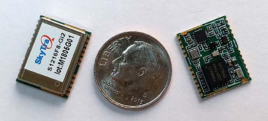
SkyTraq Technology Inc., a fabless GNSS positioning technology company, has introduced the S1216F8-GI2, a NavIC + GPS/GAGAN receiver module for the emerging Indian market.
It integrates L1/L5 RF front-end and baseband processor capable of receiving up to 14 L5 NavIC signals and up to 20 L1 GPS/GAGAN signals simultaneously. With currently usable six NavIC signals and three GAGAN signals, it offers a total of 18-23 usable signals for navigation compared to 9-14 usable signals with conventional GPS receivers, providing improved accuracy in urban canyon environments with signals often blocked by high buildings.
The S1216F8-GI2 has form-factor and pin-out compatability with popular 12 x 16-millimeter GPS receiver modules, so customers using those GPS modules can effortlessly migrate to NavIC/GPS capability by drop-in replacement and changing to an L1/L5 antenna.
For emerging intelligent transport systems (ITS) applications requiring NavIC/GPS capability in India, S1216F8-GI2 enables fast time-to-market for product manufacturers, the company said.
NavIC sub-frame data output is a useful feature of the S1216F8-GI2. It can output NavIC broadcast warning messages related to weather alerts, forecast, and natural disasters such as cyclones, earthquakes and tsunamis.
An S1216F8-GI2 engineering sample, evaluation kit and datasheet is available. Volume delivery to customers begins in late March. The S1216F8-GI2 is manufactured with ISO/TS 16949 automotive certification.