Author: Tracy Cozzens

  • Spirent partners with ESA to spearhead PNT resilience initiative for critical infrastructure

    Spirent partners with ESA to spearhead PNT resilience initiative for critical infrastructure

    Project establishes innovative test framework to help UK operators, providers and suppliers adopt best practice and benchmark success

    Spirent Communications, now part of Keysight Technologies, has partnered with the European Space Agency (ESA) to lead an initiative aimed at increasing the resilience of positioning, navigation and timing (PNT) systems used in critical national infrastructure. Under the initiative, Spirent and partners will deliver a comprehensive test framework to drive measurable resilience in PNT systems for users, operators and providers of critical infrastructure in the United Kingdom.

    Supported by Element 2 of ESA’s Navigation Innovation and Support Program (NAVISP), the initiative is designed to raise awareness and improve resilient PNT test and assessment by providing a pathway to assess, validate and rate PNT equipment and services used in critical national infrastructure. The 2023 UK government report The Economic Impact on the UK of a Disruption to GNSS estimates a seven-day GNSS outage could cost the UK economy £7.6 billion. Critical infrastructure is heavily dependent on satellite-based PNT systems and data.

    “For years, organizations have been wrestling with a fundamental challenge: they know PNT resilience matters, but they do not have a clear way to measure it or benchmark their progress,” explained Mark Holbrow, vice president of Engineering and Product Development at Spirent Positioning. “This new initiative changes that by building the tools and frameworks that let critical national infrastructure operators quantify resilience, track it, and improve it over time, and we’re proud that ESA has entrusted Spirent to lead this exciting three-year project.”

    The Resiliency in Critical National Infrastructure will support the UK government’s resilient PNT strategy by enabling access to rigorous, quantitative test evidence and operational insights that help evaluate and validate PNT systems across essential sectors. It will comprise three core components:

    • Spirent PNT Alliance brings together companies, academic research partners, and PNT professional and government bodies to identify, develop and cater resilience services for critical infrastructure. It will include the Royal Institute of Navigation and other strategic partners to complement their activities and help build a resilient PNT ecosystem in the UK by commercializing best practices and connecting infrastructure operators with new technologies and test approaches.
    • PNT Shopfront showcases solutions that aid the adoption of resilient PNT and help to assure regulatory compliance for critical PNT dependencies.
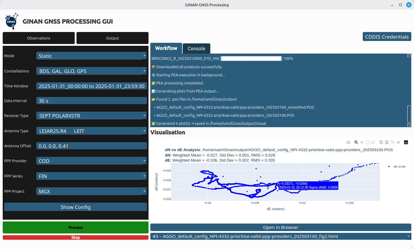
    • PNT Resiliency Health Check will enable independent appraisal of GNSS equipment capability against general performance, resilience and security criteria. Annual health check assessments will help organizations understand their dependencies, identify vulnerabilities, and track improvements over time, with a technical framework that scores resilience against standard benchmarks to create a pathway toward industry-wide test methodologies.

    “Intentional and malicious disruptions to GNSS are now a daily occurrence, and are pervasive in the aviation and maritime sector,” said Ramsey Faragher, director of the institute. “The Royal Institute of Navigation is focused on raising awareness to these issues and in promoting the needs for improved resilience against such disruptions, especially within Critical National Infrastructure. Our Best Practice Guidelines emphasize the criticality of thorough testing in order to verify resilience and to help protect against both existing and future attack vectors. The UK is well placed to take a lead in this area, and well placed to inspire other nations to follow suit. We are really pleased to see initiatives like these from our corporate partners, and we look forward to supporting them.”

  • Advanced Navigation’s inertial-centric intelligence succeeds in US Army’s contested environment

    Advanced Navigation’s inertial-centric intelligence succeeds in US Army’s contested environment

    Successful deployment at APEX validates the technology as a crucial inertial-sensor stack for assured PNT on the modern battlefield.

    Advanced Navigation successfully demonstrated in April 2025 its inertial-centric intelligent navigation as part of the U.S. Army’s All-Domain Persistent Experiment (APEX), underscoring the ability to deliver reliable, high-accuracy navigation in GNSS-degraded and -denied conditions.

    Designed for the DDIL (Degraded, Denied, Intermittent and Low-bandwidth), APEX provided Advanced Navigation with an operationally relevant testbed to evaluate the performance of its Boreas D90 fiber-optic gyroscope (FOG) inertial navigation system (INS) when fused with complementary aiding sensors, including the laser velocity sensor (LVS) and a wheel-speed encoder. The results reaffirm Advanced Navigation’s intelligent software-defined approach as a resilient foundation for APNT on the modern battlefield.

    “Assured PNT is non-negotiable. The only path to operational advantage is an intelligent, multi-sensor fusion anchored by a resilient inertial core. We deliver this with our sophisticated AdNav Intelligence software,” said Chris Shaw, Advanced Navigation CEO. “Now in our third year participating in this U.S. Army program, APEX continues to challenge our systems under realistic electronic warfare conditions.”

    Boreas D90. At the center of the architecture is the Boreas D90, a strategic-grade FOG INS that serves as the “nervous system” of the navigation stack. Unlike conventional systems reliant on GNSS or magnetic compasses, Boreas D90 determines true North through gyrocompassing, using ultra-sensitive fiber-optic gyroscopes to detect the Earth’s rotation. This enables independent, high-confidence navigation, even when external GNSS signals are compromised.

    AdNav Intelligence. AdNav Intelligence software continuously validates all sensor inputs, adjusts in real-time to the operational environment, and autonomously counteracts spoofing and jamming. The sophisticated software can adapt in real time to respond to incoming threats, dynamically weighing the input from each sensor to make real-time adjustments on which sensor to rely on based on their reliability scores, environmental conditions, and operational context.

    Demonstration setup

    During APEX, Boreas D90 with AdNav Intelligence was integrated with both a laser velocity sensor and a wheel-speed encoder aboard a four-wheel-drive vehicle. The demonstration was conducted during night operations at a site in rural New Mexico, under a created environment of complex and emerging electronic warfare threats with GNSS jamming.

    The Boreas D90 was fused with Advanced Navigation’s advanced infrared laser sensor that measures ground-relative 3D velocity with exceptional precision. LVS performs reliably on both ground and airborne platforms regardless of environmental conditions or the availability of visual references, as long as it maintains a clear line of sight to the ground or a stationary surface. By providing direct, drift-free velocity measurements, the LVS ensures continuous, high-precision mobility and enhances navigation resilience even in the most extreme contested GNSS environments.

    This configuration demonstrated dead-reckoning accuracy, achieving a 0.012% error per distance traveled (7.5 m over 65 km) in the same contested conditions.

    Wheel-speed encoder. Wheel-speed encoders offer a rugged and cost-effective source of motion data, measuring wheel rotation to determine ground speed and distance traveled. Their design ensures quick integration across tactical platforms. Ideal for firm terrain and structured routes, they provide dependable dead-reckoning performance when GNSS is denied, making them a practical choice for missions that demand reliability over complexity.

    When paired with a wheel-speed encoder, the Boreas D90 delivered reliable dead-reckoning performance useful for platforms operating in predictable or structured environments. Across the demonstration, the Boreas D90–wheel-encoder configuration maintained strong navigation continuity, achieving a 0.018% error per distance traveled (11.7 m over 65 km), without reliance on GNSS, even under deliberate jamming.

    Next Steps for APNT

    For Advanced Navigation, the results from APEX show significant potential for a range of current and future defense applications. The technologies exceeded the team’s expectations, demonstrating the level of accuracy and operational reliability required for successful navigation under GNSS-denied and -degraded conditions.

    Integrating INS with next-generation photonics promises to further advance capability, resilience and adaptability on the battlefield, Advanced Navigation said.

    About the U.S. Army’s APEX event

    Previously known as the Positioning, Navigation, and Timing Assessment Experiment (PNTAX), the sixth annual APEX event was held at the U.S. Army’s premier military test range, designed to replicate the complex, contested conditions that forces are expected to face in future multi-domain operations.

    The next experiment will include partners within the United States Air Force’s 746th Test Squadron and the Joint Navigation Warfare Center, U.S. Army Combat Capabilities Development Command, and the Army Test and Evaluation Command. Advanced Navigation expects to take part 2026.

    APEX provides a rigorous environment for evaluating mission resilience across a broader spectrum of technologies. While resilient PNT remains a core component, the event extends to integrated sensing capabilities, advanced communications architectures, data transport, and edge processing. These systems are evaluated under threat-informed, operationally realistic scenarios that reflect the evolving demands placed on modern military platforms in GPS-degraded or -denied environments.

  • Ginan team releases Ginan update v4.1.0

    Ginan team releases Ginan update v4.1.0

    Australia’s SouthPAN service software, Ginan, has received another update just six weeks after December’s v4.0 major update.

    The v4.1.0 update includes new SouthPAN SBAS capabilities and additions to the graphical user interface (GUI).

    Ginan is an open-source toolkit for creating precise point positioning (PPP) analysis products, correction streams and positions. It is being actively developed in a Geoscience Australia Positioning Australia program.

    The source code for the current version of Ginan is available for download from GitHub. New versions of Ginan with enhanced capabilities will be developed and released over time.

    Geoscience Australia is establishing operational instances of Ginan that produce PPP analysis products and streams on a continuous basis, and which are available free of charge.

    Read details of the updates on the Ginan website.

  • Syslogic introduces cm-accurate navigation with computer expansion board with u-blox

    Syslogic introduces cm-accurate navigation with computer expansion board with u-blox

    Syslogic has introduced a GNSS expansion board for its rugged embedded computers.

    Based on u-blox GNSS technology, the board provides centimeter-level positioning, opening up new applications across industries such as autonomous field management, operation of construction machinery in remote areas, or navigation of automated guided vehicles and autonomous mobile robots.

    All-band, multi-frequency reception and HAS-ready

    Syslogic’s all-band GNSS board is powered by the u-blox X20 receiver, supporting all major GNSS constellations and frequencies, including L1, L2, L5, L6 and L-band. This enables the use of the upcoming Galileo High Accuracy Service (HAS).

    HAS supplements standard Galileo Open Service positioning with correction data transmitted directly over the E6/L6 band. The result is centimeter-level positioning via GNSS signals — without the need for traditional RTK base stations, costly reference networks, or 5G connectivity. HAS is free and globally available.

    The u-blox X20-based GNSS board also supports simultaneous multi-frequency reception. With additional frequencies compared to previous models, typical GNSS errors — such as multipath effects and signal blockage — are significantly reduced, particularly in urban environments. This is crucial for applications that demand highly precise and reliable positioning, including surveying, autonomous vehicles, agricultural machinery and industrial automation.

    The GNSS board is designed for worldwide use. The integrated u-blox receiver supports modern correction techniques such as RTK, PPP-RTK and PPP. For the first time, it has been fully optimized for PointPerfect Global, u-blox’s proprietary high-precision GNSS correction service, delivering centimeter-level positioning anywhere in the world. This is particularly useful in remote areas without cellular coverage. PointPerfect Global uses advanced PPP-AR technology (precise point positioning with ambiguity resolution), providing corrections via the Internet or L-band satellite transmission. The service achieves convergence times of less than 2 minutes and positioning accuracy within 10 centimeters.

    The new expansion board is compatible with Syslogic embedded computers, including both Nvidia Jetson-based and x86-based devices. It is available with either one or two receivers, enabling RTK and heading functions without additional hardware. Vehicles and machines can be positioned with centimeter-level accuracy.

    Several Syslogic customers are already using the GNSS functionality in pilot projects, including precision farming and construction machinery monitoring.

    Features of the Syslogic all-band GNSS board

      • Based on the u-blox X20
      • All-band, all-constellation GNSS receiver
      • RTK, PPP-RTK and global PPP, cm-level accuracy
      • PPS output to host system (GPIO)
      • Galileo HAS support on L6 band
      • Flexible integration into Syslogic products
      • Extended temperature: –40°C to +85°C
    • Furuno and Xona Space Systems sign MoU to develop innovative LEO PNT solutions

      Furuno and Xona Space Systems sign MoU to develop innovative LEO PNT solutions

      Furuno Electric and Xona Space Systems have signed a Memorandum of Understanding (MoU) to collaborate on solutions using Xona Pulsar, a low-Earth-orbit positioning, navigation and timing (LEO PNT) service for next-generation satellite navigation.

      Through the agreement, both companies will leverage their respective technological expertise and business strengths to explore opportunities for delivering advanced and promising LEO PNT solutions.

      Furuno has been actively pursuing LEO PNT as a promising technology capable of complementing or even substituting for GNSS.

      LEO PNT refers to systems that use a satellite constellation of 200 to 400 satellites deployed in low Earth orbit at an altitude of 500 km to 2,000 km. The LEO constellation is designed for PNT rather than non-terrestrial networks to provide global positioning and timing services similar to GNSS, but with significantly better performance.

      Xona is a pioneer in LEO PNT technology and offers a commercial service called Pulsar, which uses a dedicated LEO PNT constellation of 258 satellites. Compared to conventional GNSS, this service enhances resiliency and improves the accuracy of positioning and timing — the proximity of LEO satellites to Earth makes their signal power about 100 times stronger.

      Pulsar adopts a signal architecture similar to GNSS for compatibility, making it easy to integrate into existing GNSS products. Integrating Xona Pulsar into Furuno’s products will provide an alternative to GNSS while significantly boosting performance by complementing existing GNSS services.

      Furuno’s Pulsar-enabled timing solutions allow users to maintain accurate synchronization even when GNSS is degraded due to unexpected failures, including jamming and spoofing, the companies said.

    • UK invests in satellite timing infrastructure to strengthen national PNT resilience

      UK invests in satellite timing infrastructure to strengthen national PNT resilience

      GMV is leading the development of a secure two-way satellite time and frequency transfer system under the European Space Agency’s TOUCAN project.

      The initiative safeguards critical infrastructure by reducing reliance on GNSS and enhancing national positioning, navigation and timing (PNT) capabilities.
      Funded by the UK Space Agency through its membership in ESA’s Navigation Innovation and Support Program (NAVISP), the project is an important part of the UK Government’s Framework for Greater PNT Resilience.

      Through a competitive process, GMV was selected to enhance the UK’s national capabilities in delivering nationally assured, secure and continuous PNT services for critical infrastructure, defense and the broader economy.

      TOUCAN, the two-way satellite time and frequency transfer capability demonstration (TWSTFT), will draw on GMV’s expertise in time transfer and system-level engineering, reinforcing the company’s role in supporting the government’s PNT resilience efforts.

       TOUCAN represents a strategic milestone for GMV. It underscores our commitment to delivering cutting-edge, nationally assured, PNT solutions that are vital to the UK’s critical infrastructure and national security,” said Mark Dumville, general manager of GMV in the UK.

      eLoran support

      TOUCAN complements efforts to reestablish a UK eLoran system, which will serve as a terrestrial backup to satellite-based services. A critical goal is to ensure that this system operates independently of the more vulnerable GNSS.

      The project’s primary objective is to establish an accurate, independently verifiable TWSTFT link between the eLoran transmitter and the National Physical Laboratory (NPL), the UK’s official timekeeping authority. The new link will address GNSS-dependence within eLoran, maintaining a time traceable to UTC (NPL).

      In addition, the system will provide a TWSTFT connection to a facility that operates an R&D timescale, a secure reference that will one day be essential for synchronizing operations, maintaining communication integrity, and supporting mission-critical systems.

      “Precise and secure timing is at the heart of so much we rely on every day, from banking and transport to energy and communications,” said Paul Bate, CEO of the UK Space Agency. “This investment in UK satellite timing through TOUCAN is about more than technology; it’s about protecting the everyday services people and businesses depend on. By working with GMV, the PNT Office and ESA’s NAVIS program, we’re helping to build a stronger, more resilient space ecosystem that safeguards our security and keeps the UK at the forefront of innovation.

      GMV is delivering the design, integration and operational demonstration of the system, building on its proven track record in delivering secure national timing products and infrastructure. Project partner Viasat is supplying satellite bandwidth, as well as supporting GMV in analyzing innovative TWSTFT technology evolutions.

    • Hexagon | NovAtel updates firmware with advancements in GNSS reliability

      Hexagon | NovAtel updates firmware with advancements in GNSS reliability

      Hexagon | NovAtel has released its latest firmware for the OEM7 family of GNSS receivers, featuring improvements in positioning reliability and accuracy.

      Proven in tough defense markets, and now available for all customers, the firmware release sets new standards for innovation and reliability with the introduction of advanced tracking capabilities that enhance GNSS performance in challenging or obstructed environments, such as under foliage or in mixed urban scenarios.  

      Customers can now benefit from enhanced position accuracy and availability, leveraging NovAtel’s SPAN GNSS+INS technology, precise point positioning (PPP), and real-time kinematic (RTK) capabilities. This ensures greater operational availability and reduced downtime, according to the company.

      Key features

      • Tracking improvement of 5-7 decibels (dB) and acquisition improvement of 4-5 dB for most GNSS signals
      • PPP root mean squared (RMS) error improvement up to 26% under challenging conditions
      • RTK RMS error improvement up to 15% under challenging conditions
      • Up to 48% improvement on the 3D position error when using SPAN in severely GNSS-challenged environments.

      “Our latest firmware release is a testament to our dedication to innovation and customer success,” said Jonathan Auld, president, NovAtel Positioning Division, Hexagon. “By enabling receivers to track weaker signals and maintain positioning in the most challenging environments, we are empowering our customers with the tools they need to overcome obstacles and achieve their goals with confidence.”

      The latest firmware for OEM7 GNSS receivers is now available. Visit NovAtel to download it for your specific platform.

    • RIN report: How GNSS interference harms maritime safety

      RIN report: How GNSS interference harms maritime safety

      The UK Royal Institute of Navigation has released a special report on GNSS-interference and its impact on the maritime sector.

      Impacts of GNSS Interference on Maritime Safety is a special report by the RIN Maritime GNSS Interference Working Group on the impacts of GNSS Interference. Survey data was compiled from more than 100 sector experts and 300 vessel captains, supported by interviews with dozens of people involved in the operations and supply chain of vessels that regularly encounter GNSS interference.

      GNSS interference refers to anything that disrupts a ship’s satellite-based positioning signals, usually caused by jamming and spoofing.

      In 2025, at least two collisions and groundings were reported in mainstream media linked to GNSS interference in regions such as the Baltics, Straits of Hormuz and the Red Sea. With hundreds of vessels being affected daily, the RIN report details for the first time the scale of the problem on modern digital vessels, where GNSS jamming and spoofing present a significant cybersecurity vulnerability and urgent risks to maritime safety.

      Survey data exposes the vulnerability of critically important systems such as Global Maritime Distress and Safety Systems (GMDSS) and other SOLAS-mandated equipment that rely on satellite positioning and timing. 

      “The report has highlighted serious safety concerns and has underlined the fact that these issues are rooted in significant cybersecurity vulnerabilities, and are not just disruptions to navigation,” said Ramsey Faragher, director of the RIN. 

      Operating within regions of known GNSS interference carries serious safety-of-life and liability implications, as key systems are expected to fail or malfunction with high probability in these conditions. The report also highlights unnecessary dependencies between GNSS receivers and a range of onboard electronics — including radar, radios (VHF/MF/HF), Navtex, speed logs, ship clocks and satellite communications — many of which do not require GNSS data for their primary function, creating avoidable points of failure and compounding operational risk.

      “The issue of GNSS interference must be taken seriously. It cannot be overcome by traditional navigation techniques when GNSS receivers are ‘baked in’ to modern ships’ critical systems, including safety systems,” said Ivana-Maria Carrioni-Burnett, maritime captain and chair of the RIN Maritime Navigation Group. “These are no longer isolated incidents and pose a real risk to life: people, property and the environment. We must do more to safeguard our seas today and the shipping of tomorrow.”

      “Despite measures to improve resistance to jamming, spoofing and other harassment measures, the threat is real and growing,” said Retired Commodore James Taylor OBE and fellow of the RIN advises. “And this threat is not only to positioning and navigation; it is to every part of every transport and navigation means and to every part of national infrastructure where timing is derived from space-based timing signals.”

      The Royal Institute of Navigation will continue to work with report partners (GLA, IALA, Nautical Institute and others) and regulatory bodies to provide expert guidance to mitigate these issues, and to establish industry-wide adoption of solutions to this problem. RIN thanks National PNT Office for its support.

      Download the report for free.

    • TDK launches STRIDE, a low-power, real-time positioning software for wearables and IoT 

      TDK launches STRIDE, a low-power, real-time positioning software for wearables and IoT 

      TDK Corporation has announced Trusted Positioning STRIDE, an embedded pedestrian dead reckoning (PDR) software solution engineered specifically for wearables such as smart watches, head-mounted devices, glasses and compact sensors.

      As OEMs push for more intelligent, context-aware wearable experiences, STRIDE provides reliable positioning without the power and hardware demands traditionally required for GNSS-based tracking. 

      Wearables today face a critical challenge: adding high-quality positioning typically requires bulky antennas, high-drain GNSS or costly custom hardware — barriers that limit form factor, battery life, and user experience. 

      STRIDE overcomes these constraints with a low-power, sensor-agnostic software engine that fuses inertial data with GNSS and opportunistic wireless signals, delivering continuous location tracking indoors, outdoors and everywhere in between. 

      STRIDE runs as embedded software, giving OEMs freedom to deploy positioning without redesigning hardware or relying on cloud connectivity. STRIDE processes sensor data in real time, ensures low latency, and can be configured for on-device, companion-device, or cloud-assisted architectures. This flexibility helps manufacturers balance performance, power, and form-factor constraints based on their device strategy. 

      For integration questions or technical documentation, contact TDK.

    • UAVOS introduces stratospheric Earth observation payload after successful flight tests

      UAVOS introduces stratospheric Earth observation payload after successful flight tests

      UAVOS has completed successful flight testing of its optoelectronic, gyro‑stabilized payload onboard device (POD), integrated into the HAPS ApusNeo 18. The ApusNeo 18 is a solar‑powered high‑altitude pseudo‑satellite developed as part of a joint project with Mira Aerospace.

      Using steerable high-resolution cameras, the system demonstrated coverage of 472 km of electro‑optical imagery with a ground sampling distance of 69 cm per pixel, as well as infrared imagery at 480 cm per pixel, from an altitude of 15,000 m. The camera’s footprint covered 53.9 km², while its steerability allowed access to any point within a 54.5 x 12.3 km area at any time.

      Designed specifically for stratospheric operations, the POD significantly enhances the intelligence, surveillance and reconnaissance capabilities of HAPS platforms. 

      The POD weighs 3.6 kg and features a compact form factor measuring 845 mm (length) × 128 mm (width) × 142 mm (height). It is equipped with an onboard computer for data processing and a UAVOS radio modem with a 10 W amplifier, enabling high‑throughput data transmission to the ground control station.

      To ensure reliable high-altitude performance, the POD incorporates an integrated heating and cooling system that maintains optimal operating conditions for onboard sensors. It also includes a foldable, servo‑driven antenna that can be stowed  in a safe position when required.

      Additionally, the mechanical design enables video and photo acquisition with roll stabilization of up to ±50 degrees, expanding operational flexibility and imaging performance.

      The Payload Onboard Device (POD) has already been successfully tested for wildfire monitoring in Spain. When integrated with the HAPS ApusNeo 18, which is capable of surveying hundreds of kilometres in a single flight, the system delivers a comprehensive situational picture, improving operational efficiency, reducing costs, and increasing overall mission effectiveness,” said Aliaksei Stratsilatau, founder and CEO of UAVOS.

    • AirData expands global access to drone fleet platform with 8 new languages

      AirData expands global access to drone fleet platform with 8 new languages

      The full platform experience is now available in English, Spanish, Portuguese, French, German, Italian, Japanese and Hebrew.

      AirData, a drone fleet data management platform used by organizations worldwide, today announced that its platform is now available in eight languages across both the web application and mobile apps. Supported languages include English, Spanish, Portuguese, French, German, Italian, Japanese and Hebrew.

      AirData is used by a wide range of commercial, public safety and government drone programs, helping operators manage daily operations, reporting and compliance across distributed teams. The addition of platform translation reflects efforts to improve accessibility and usability to meet demand from international customers.

      AirData automatically displays the platform interface in a supported language, with no manual configuration, plugins or external translation tools required. The default language is determined by the preferred language settings of the user’s device or browser.

      The translated interface supports navigation and workflows across daily drone fleet operations and is available across the AirData web application and mobile apps. AirData plans to continue expanding localized support over time, including additional languages, region-specific regulations, compliance requirements, and airspace considerations.

      An AirData wind map aids in drone fleet planning. (Image: AirData)
      An AirData wind map aids in drone fleet planning. (Image: AirData)
    • Inertial Labs launches IRINS LEO-aided inertial navigation system

      Inertial Labs launches IRINS LEO-aided inertial navigation system

      Inertial Labs, a Viavi Solutions Inc. company, has announced IRINS, a low Earth orbit (LEO)-aided inertial navigation system (INS) designed to allow full operation across land, air and sea in GNSS-denied, -degraded and -disrupted space operating environment .

      Combining the capabilities of an INS, an altitude and heading reference system (AHRS) and a LEO PNT receiver, this platform marks a major milestone in Viavi’s portfolio for assured positioning, navigation and timing by bringing together the INS capabilities of inertial labs and the timing expertise of Jackson Labs.

      The IRINS embedded system has been developed to counter the exponentially rising number of spoofing and jamming attacks that have affected military and critical infrastructure. Now, resilient LEO-based PNT and inertial navigation are available within a fully integrated system from a single vendor.

      The system combines an INS, an AHRS and the GNSS-independent STL-2600 LEO Iridium receiver module. These capabilities enable the system to calculate altitude, position, velocity and time data, as well as minimize bias from causing drift. To help detect and eliminate attack signals, the device additionally integrates a GNSS receiver with a controlled reception pattern antenna (CRPA) port.

      “The IRINS is the first fruit borne of VIAVI’s visionary strategy to mitigate vulnerabilities in positioning, navigation and timing, bringing together resilient satellite-based timing with tactical-grade IMUs to deliver the most precise PNT for GNSS-denied environments,” said Jamie Marraccini, vice president, Inertial Labs Products, Viavi. “By tightly coupling inertial sensing, LEO-based timing and navigation and anti-jam GNSS technologies into a single platform, the IRINS provides unmatched continuity, accuracy and trust for operations in contested and denied environments.”

      “Assured access to PNT is critical for operations in contested environments,” said Maynard Porter, Director, Government PNT Business, Iridium. “Integrating Iridium PNT alongside VIAVI’s INS and AHRS provides users with an exceptionally resilient source of time and location data to maintain operational effectiveness when GNSS signals are disrupted.”

      The IRINS is certified for IP67 and MIL-STD-810G environmental requirements. It is based on the company’s fully calibrated tactical-grade MEMS 3-axis accelerometer, gyroscope and clock. These are combined with embedded barometers, magnetometers and an optional onboard air-data computer as part of its AHRS.

      Satellite communication is provided through the company’s STL-2600 receiver, which links to the Iridium LEO constellation. All capabilities are housed within a compact 126.5 × 49.3 × 53.3 mm enclosure.