Topcon Positioning Systems has signed a commercial agreement with Xona to secure early-adopter access to Pulsar, Xona’s low Earth orbit (LEO) satellite navigation constellation. This agreement positions Topcon among Xona’s first commercial customers preparing to integrate Pulsar into future high-precision positioning workflows.
“The letter of agreement reinforces Topcon’s long-standing commitment to innovation and customer-driven technology leadership,” said Ron Oberlander, head of the Topcon Geomatics Platform. “It lays the groundwork for a new era of high-precision performance possibilities as LEO satellites come online. By proactively adopting next-generation navigation infrastructure, we strengthen our commitment to provide reliable, resilient, and future-proof solutions for our customers.”
“Topcon understands where accuracy, continuity and confidence matter most for operators in the field,” said Bryan Chan, co-founder and VP of Strategy at Xona. “By adding a modern navigation layer into Topcon’s offerings, Pulsar will strengthen signal performance and resiliency in even the most challenging environments, ensuring Topcon customers can operate with greater confidence wherever their work takes them.”
Safran Electronics & Defense has acquired Syntony GNSS, a simulator and receiver company founded in 2015 in Toulouse, France. The acquisition is intended to strengthen Safron’s resilient PNT innovations.
Under the agreement, signed Feb. 13, Safran will take 100% of Syntony’s share capital, subject to customary regulatory approvals. Financial terms were not disclosed.
A European leader in GNSS solutions for underground environments, Syntony has developed unique expertise to ensure reliable positioning in contexts where satellite signals are unavailable.
Syntony’s technology addresses a major challenge of satellite navigation systems: the vulnerability of GNSS signals to physical obstacles, jamming and interference. To tackle this, Syntony has developed several critical technologies, including:
Controlled reception pattern antennas (CRPAs) that make GNSS receivers less sensitive to jamming and spoofing — essential for flight safety and the protection of sensitive infrastructure.
Software-defined radio (SDR), a digital radio that can change function (switching from FM to Wi-Fi or GPS) through a simple software update without changing hardware, allowing it to adapt to threats or to changes in received or transmitted signals. It offers compactness and scalability, particularly suited to embedded systems and the requirements of modern operational environments.
In addition, Syntony develops GNSS receivers for next-generation satellites, particularly for low Earth orbit (LEO) constellations, further strengthening Safran Electronics & Defense’s offering in the space-based PNT and New Space sectors.
Syntony employs nearly 70 people across Toulouse and Paris.
For Safran Electronics & Defense, this acquisition makes it possible to offer more comprehensive equipment that is also more compact and energy-efficient, while remaining adaptable to the constant evolution of signals. These gains in weight and power consumption are essential for future civilian and military platforms (drones and counter-drone systems, missiles, aircraft and low-orbit satellites).
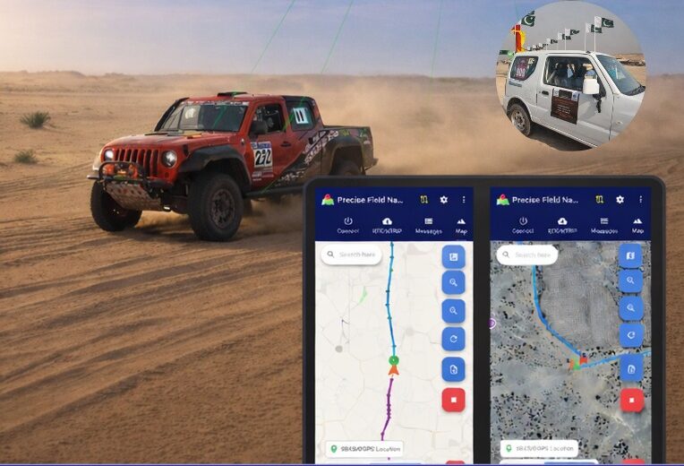
Pakistan’s national space agency SUPARCO (Space and Upper Atmosphere Research Commission) has achieved a major milestone in navigation technology with the successful launch of its Pak-SBAS satellite-based augmentation system (SBAS) device and service.
The Pak-SBAS navigation service was rigorously tested in the extreme desert conditions of Cholistan during Cholistan Desert Rally 2026. The Cholistan desert experinces high speeds, unpredictable routes, and the absence of visual landmarks that demand exceptional positioning accuracy and signal reliability for autos and motorcycles.
Throughout the rally, Pak-SBAS demonstrated remarkable performance by delivering highly precise location data, stable signal continuity, and integrated route tracking.
By applying SBAS corrections, the system significantly reduced positioning errors compared to conventional GNSS technologies, offering rally drivers and navigation teams a new level of confidence essential for competitive desert racing.
According to a SUPARCO spokesperson, the Pak-SBAS technology holds vast potential beyond motorsports. It is expected to enhance disaster response operations through accurate tracking of rescue teams and affected areas, improve transport efficiency via real-time vehicle positioning, and strengthen aviation safety with more reliable navigation support.
The system also will benefit the surveying and mapping sectors by minimizing positional inaccuracies and reducing project costs.
A second MOU was signed with Elistair to introduce tethered unmanned aerial systems into Milanion’s ground and maritime architecture.
The agreements focus on maintaining operational capability in environments affected by electronic warfare, GNSS denial, jamming, spoofing and cyber interference, with technical integration work scheduled to begin after the exhibition and demonstrations planned for later in 2026.
The agreement with NovAtel covers land, maritime and air domains and focuses on operations in contested environments where electronic warfare, GNSS denial and cyber interference are present.
Milanion linked the partnerships to requirements raised by defense delegations at WDS 2026 for unmanned systems that remain operational without dependence on vulnerable networks and that support sovereign-ready integration.
Technical integration discussions with both companies are scheduled to begin immediately after the exhibition. Joint development pathways and capability demonstrations are planned later in 2026 as part of a broader connected autonomy architecture.
Milanion Group was founded in 2020 and is headquartered in the UK, with manufacturing in Abu Dhabi. The company develops autonomous and optionally manned systems for military and security missions across land, sea, and air.
The MOU with NovAtel will embed NovAtel assured-PNT and anti-jam technologies into Milanion assets to maintain navigation accuracy and mission integrity during GNSS denial or interference. The integration supports secure routing, guidance stability, and targeting precision even when GPS signals are degraded or disrupted. This capability is relevant for unmanned ground vehicles, maritime conversions, and airborne systems operating in electronically contested theatres. Milanion links the functionality to survivability and operational continuity during electronic warfare and cyber-disruption scenarios.
By combining assured navigation with persistent ISR and resilient communications, the company aims to maintain autonomous mission performance across multi-domain deployments. The approach integrates sensing, navigation, and communications into a unified architecture to address contested-environment requirements identified at WDS 2026.
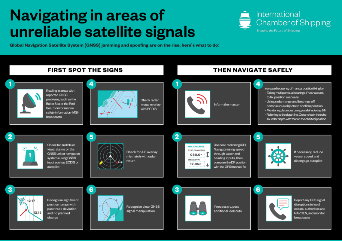
The International Chamber of Shipping (ICS) and its members have produced an informational poster for ship crews that highlights strategies when GNSS signals are jammed or denied.
The Navigating in Areas of Unreliable Satellite Signals poster is available for free on the ICS website. Crews are welcome to download and print it for display near the conning position on board navigation bridges.
Modern maritime operations depend heavily on GNSS. From open-ocean routing to precise harbour maneuvers, satellite-based positioning data is deeply embedded in ship systems, port logistics, traffic monitoring and safety infrastructure.
This reliance, however, has created a growing vulnerability. Incidents of GPS jamming and spoofing, once a military concern, now increasingly affect merchant ships at sea and near ports. Without proactive preparation and mitigation, interference with satellite navigation threatens vessel safety, global trade efficiency, port operations and maritime security.
To support crews facing these incidents, the poster helps bridge officers identify the signs of compromised satellite signals and recommends best practices to maintain safe navigation.
“The safety of our seafarers, ships, and the environment is critical,” said Gregor Stevens, ICS Nautical Director. “With ever-increasing frequency of jamming and spoofing of GPS, this new free resource helps seafarers recognize the warning signs and provides guidance on navigating these waters safely.”
Dedicated research and development, funded by European Union (EU) and European Space Agency (ESA) programs over the years, has played a key role in Galileo Second Generation.
Among the innovations that will benefit the new satellites are the development of new atomic clocks, links that allow the satellites to “talk” to one another in orbit and a prototype ground station that can precisely pinpoint satellites in the sky. These advanced technologies will ensure Galileo continues to provide world‑class positioning, navigation and timing to users worldwide.
The importance of R&D
Satellite navigation is constantly evolving, with new technologies being deployed. But before a technology can fly on a satellite, it must be derisked and qualified. This is where research and development (R&D) comes in, laying the groundwork for new technologies long before they see the light of day.
Horizon 2020 and Horizon Europe are R&D programs funded by the EU. A significant budget from these programmes is delegated to ESA for R&D to derisk new technologies for evolutions of Europe’s Galileo and EGNOS systems.
Complementing these EU R&D programs, ESA programs such as the General Studies Programme (now Discovery and Preparation), General Support Technology Programme and the former European GNSS Evolution Program (EGEP) have also performed R&D for future satellite navigation technologies.
R&D spurs the innovation that allows Galileo and EGNOS to modernise and develop new applications and services. Several activities funded through these programmes have contributed to Galileo Second Generation (G2). Some of these technologies will already fly on the G2 satellites when they are launched in the coming years.
New ways of keeping time
Galileo relies on highly precise onboard atomic clocks to ensure accurate global positioning and timing. Here, an iodine optical clock by SpaceTech, Germany (Credit: ESA)
Galileo delivers world-class positioning and timing, and its onboard clocks are the key to its performance. Each first generation Galileo satellite carries two passive hydrogen maser and two rubidium atomic frequency standard clocks. These clocks, developed by Leonardo and Safran Timing Technologies, respectively, are currently Galileo’s only space-qualified clocks.
A rubidium pulsed optically pumped (Rb POP) clock by Leonardo, Italy. (Credit: ESA)
To keep up with the latest technologies and allow for a broader diversity of European qualified clocks, R&D activities have encouraged European companies to develop new types of space-worthy atomic clocks. This investment is critical due to the time and expertise it takes to develop such complex and sensitive technologies. These activities aimed to develop alternative atomic clocks for Galileo that can improve performance and robustness and support Europe’s place as a leader in satellite navigation.
A Mercury ion clock (MIC) from Safran Timing Technologies, Switzerland. (Credit: ESA)
Seven innovative clock technologies were developed by European companies from France, Germany, Italy and Switzerland. After initial development activities, three of these clocks — proposed by Leondardo, SpaceTech and Safran Timing Technologies — were selected to progress to hardware development in preparation for a first flight.
Leonardo’s Rubidium Pulsed Optically Pumped clock is currently under development and planned to fly as an experimental clock on a Galileo Second Generation satellite. The Iodine Optical clock developed by SpaceTech is undergoing early development and shows potential for future use as an experimental clock on Galileo satellites. The Mercury Ion clock by Safran Timing Technologies recently launched its development activities.
Following an analysis of the clocks’ eventual in-orbit performance, a programme decision by the European Commission will be made before starting the operational phase of these new clock technologies.
Conversations in the sky
An intersatellite link transceiver by Thales Alenia Space. (Credit: ESA)
The Galileo system currently relies on links between satellites and ground stations to monitor and control the satellites and to determine the onboard clock skew. Clock skew occurs when a clock signal reaches different parts of a system at different times, which can cause errors in position calculations.
Galileo Second Generation will introduce inter-satellite links (ISL), allowing the satellites to ‘talk’ directly to one another in orbit. This will enable additional time synchronisation and ranging measurements that will improve knowledge of the satellites’ orbit and clock skew.
ISL will also allow faster data dissemination. If a particular satellite is not visible to a ground station, information can be sent to a different satellite and then passed on instead of waiting for the satellite to be visible.
An intersatellite link transceiver by Airbus Defence and Space. (Credit: ESA)
Two early models of ISL transceivers that are essentially identical to those which will fly on the Galileo Second Generation satellites were designed and developed. The transceivers, which can both send and receive signals, were developed by Thales Alenia Space (Spain) and Airbus Defence and Space (Germany).
One of these transceivers is about to enter the formal testing phase, while the other has undergone successful environmental qualifications. After the transceivers have completed their qualifications and testing, they will be ready for their trip to space.
Precisely pinpointing satellites
Accurate positioning, navigation and timing relies on knowing precisely where satellites are in their orbits. Galileo satellites are located by tracking their L-band antenna transmissions from the ground. Each satellite also has a laser retroreflector, which allows measurement of their orbit to within a few centimeters. Known as satellite laser ranging (SLR), this method measures the time it takes for a laser pulse to make the trip from a ground station, called an SLR station, to the satellite and back, then uses these measurements to determine the satellite’s orbit. Presently, SLR stations are owned and operated by scientific community users and serve multiple space missions.
One of the challenges of current SLR is the fact that the lasers are not safe for human eyes and cannot be used if an aircraft is flying nearby as the lasers could blind the pilots. This means SLR stations must coordinate with civil aviation and may not be allowed to use all parts of the sky. SLR stations also have limited availability due to local atmospheric conditions (clear skies are key), and low levels of automation (intensive need for human operators).
A prototype satellite laser ranging station in Matera, Italy. (Credit: ESA)
To mitigate these limitations, a modernized, eye-safe SLR station prototype for Galileo satellites has been developed by DiGOS (Germany) and commissioned in Matera, Italy. Due to the station design and laser wavelength used, there will be no need to coordinate with civil aviation. The station’s new technologies also explore increased automation using a predefined schedule to reach satellites. Although human operators are still needed, their workload is reduced.
A field campaign of the prototype SLR station is planned for this year as part of the Galileo Second Generation System Test Bed tasks. It will evaluate the potential benefits of SLR as a complement to L-band ground ranging. If the station is added to the Galileo ground segment, it could enhance the system’s robustness by providing an independent means of determining the satellites’ locations. In this case, interface design adjustments would need to be made to allow operational use of the station.
Beyond providing another method for determining Galileo satellite orbits, this station could also help contribute to the Galileo Terrestrial Reference Frame and could support ESA navigation scientific missions such as Genesis.
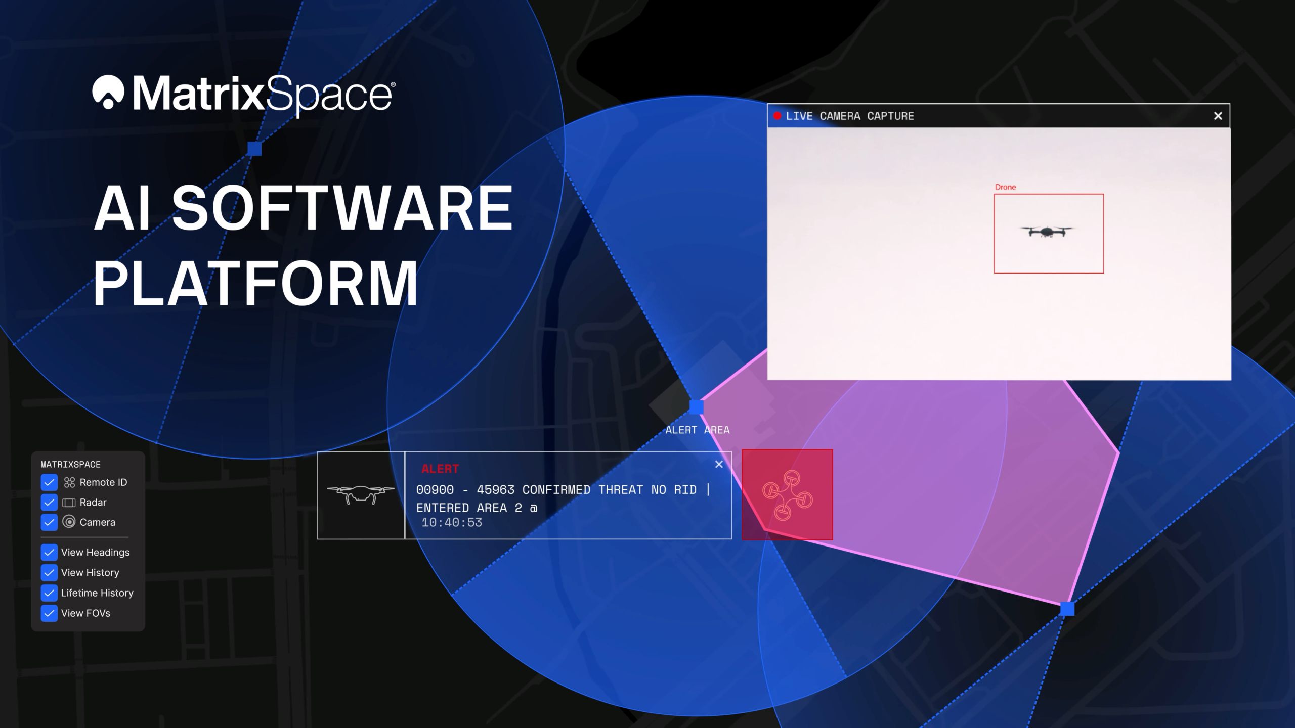
The platform now supports multi-sensor, multi-drone detection in real time for counter UAS applications. It delivers true threat assessment and early warning — detecting, tracking and identifying — to empower on-site and remote operators to make split-second decisions regarding airspace activity. The platform is sensor agnostic and easily integrated into existing systems through open APIs.
The update dramatically improves assessing risk from small, low-flying drones in complex airspace, such as public events, critical infrastructure and battlespaces.
The platform
The MatrixSpace AI Platform consists of MatrixSpace AiEdge, the company’s intelligent sensor operating system, and MatrixSpace AiCloud, a software-as-a-service that collects data from AiEdge-enabled sensors for a unified view of airspace activity. Unlike other offerings retrofitted for AI, MatrixSpace AiEdge and AiCloud are AI-native, making information rapidly actionable and easier to comprehend.
MatrixSpace AiEdge, embedded in every MatrixSpace system, provides actionable intelligence at the point of sensor data collection. It detects, classifies and tracks multiple object types, removing clutter to present a relevant picture of aerial activities, while fusing feeds from different sensors.
AiEdge fuses detections from MatrixSpace radars with complementary sensors such as Remote ID and ADS-B into a single, real-time track. By correlating multi-sensor data at the edge, AiEdge creates a common data representation and cues PTZ (pan-tilt-zoom) cameras for rapid visual confirmation, passing high-confidence tracks to the cloud for enterprise-level analysis.
Sitting above distributed AiEdge deployments, MatrixSpace AiCloud simplifies the management of geographically diverse sensor networks into a single, unified view. Instead of a bank of monitors displaying individual sensor feeds, AiCloud provides operators with clear visibility into low-airspace activity, alerts, and warnings across all protected sites — accessible on any device.
MatrixSpace AiCloud combines fused, real-time data from radar, optical, ADS-B and Remote ID sensors to deliver consistent object tracking and actionable threat intelligence at scale. Within AiCloud, whitelisting and threat classification determine whether objects are friendly, unknown, or hostile, enabling fast, coordinated operator response. Local sensors continue operating autonomously when cloud connectivity is disrupted, with all activity synchronized for review once connectivity is restored.
Divirod and Oki Electric Industry (OKI) have completed a project to monitor landslide risk and slope stability across vulnerable areas in the Fukuoka Prefecture of Japan. The project deployed Divirod’s next-generation ground deformation and anomaly-detection technology to provide continuous, high-resolution monitoring of mountainous terrain prone to extreme rainfall and seismic activity.
The initiative supports Japan’s broader effort to enhance early-warning capabilities and strengthen climate resilience following recent years of severe rainfall disasters and complex terrain-related hazards.
Monitoring with GNSS-R technology
For the project, Divirod designed a system comprised of GNSS-Reflectometry (GNSS-R) sensors and intelligent algorithms and deployed it across three areas of interest collecting continuous, all-weather measurements throughout the monitoring period. Divirod’s proprietary algorithms examined daily GNSS-R measurements to detect even subtle changes in the ground surface.
Divirod’s system successfully classified the observed terrain changes into three key physical categories:
Slope failure events,
Creep/slow-moving landslides, and
Temporary terrain changes (often linked to rainfall or ground moisture variations).
Hundreds of terrain changes were detected across the monitored regions and correlated with rainfall measurements and earthquake events. The results enabled detailed risk mapping and precise identification of active zones.
The technology proved highly sensitive in differentiating short-lived disturbances from long-term geomorphological changes — an essential capability for early intervention and warnings.
Documented landslide at Hakikoga
A significant project highlight was successful detection of a real landslide event in August. While comparison images taken on Aug. 10 and 11 revealed visible changes in the slope during daylight hours, Divirod’s terrain change maps show that the slope movement itself occurred overnight, a time when on-site cameras were unable to observe the event due to darkness.
Despite the lack of visual evidence, Divirod’s GNSS-R sensors registered a distinct spike in ground-movement, accurately detecting the terrain shift and providing clear evidence of a nocturnal landslide that could have otherwise gone unnoticed.
Strengthening the disaster-preparedness ecosystem
Divirod’s collaboration with OKI represents a significant advancement in real-time terrain intelligence for Japan, a region characterized by frequent typhoons, intense rainfall and high seismicity. The successful deployment in the Fukuoka Prefecture presents new opportunities for:
scalable early-warning systems,
automated landslide risk modeling,
and the integration of GNSS-R sensing with existing monitoring infrastructure.
Micro-Magic has released the U4930 series, a reliable and cost-effective six-axis MEMS inertial measurement module that can be widely used in navigation, control and measurement fields for vehicles, ships and drones.
Typical applications include vehicle/ship attitude measurement, UAV attitude reference and trajectory control, mobile mapping, track inspection, underwater high-precision navigation, and Satcom-on-the-Move.
The U4930 series integrates high-performance MEMS gyroscopes and MEMS accelerometers within an independent structure. The three-axis MEMS gyroscopes sense the angular motion of the carrier, and the three-axis MEMS accelerometers sense the linear acceleration of the carrier.
The system internally performs compensation for zero bias, scale factor, non-orthogonal error, and acceleration-related terms across all temperature parameters, maintaining high measurement accuracy over a long period of time.
The module supports custom communication protocols and provides synchronization for GPS/GNSS time data and pulse per second (PPS) signals.
The U4930A series inertial measurement module can be configured with various hardware and software to meet user needs.
China has launched a short messaging service leveraging BeiDou (BDS) to provide reliable communication during emergencies when ground-based mobile networks are unavailable, reports Xinhua.
The service was introduced by China Space-Time Information Co. Ltd., the national operator of BeiDou services, in collaboration with major domestic telecom carriers.
The service is be a supplement to terrestrial mobile networks, expected to enhance safety and communication reliability for users across scenarios such as hiking in remote mountains, working at sea, and disaster relief and emergency coordination.
It marks a significant step toward bringing satellite communication technology to the public, integrating BeiDou’s capabilities into daily life and offering tangible technological protection.
The service uses the short-message communication capability built into the BeiDou system, enabling users with compatible smartphones to send and receive text messages directly via BeiDou satellites in areas without cellular coverage.
China’s three primary telecom operators — China Mobile, China Telecom and China Unicom — have all integrated the service. Subscribers can activate the service without changing their SIM cards or phone numbers, according to the company. Nearly 60 smartphone models from leading Chinese brands already support the functionality.
China Space-Time Information specializes in satellite navigation and communications, big data services, artificial intelligence development, and geospatial remote sensing.
Australia-based Aptella is offering free access to its AllDayRTK high-accuracy positioning service for volunteers and organizations involved in bushfire and flood recovery efforts.
Reliable positioning aids in coordinating recovery operations, assessing damage and restoring essential infrastructure. However, extreme weather events often disrupt permanent GNSS base stations due to power outages and loss of internet connectivity.
To address this challenge, AllDayRTK has developed a Synthetic Base Station system, enabling high-accuracy positioning even when permanent bases are offline. This technology creates a virtual reference station network that ensures continuity of service in disaster-affected regions, supporting emergency response teams and volunteers where traditional infrastructure cannot.
Key Benefits:
Free access for registered volunteers and recovery organizations.
High-accuracy GNSS positioning for mapping, surveying and logistics.
Synthetic Base Station technology ensures service continuity without reliance on damaged or offline permanent bases.
“Aptella is always willing to do what we can to support volunteer services with high-accuracy positioning that assist with recovery after natural disasters and extreme weather events,” said Greg Macklin, CEO at Aptella. “Our commitment is to ensure that those on the front lines have the tools they need to rebuild communities quickly and safely.”
Contract strengthens the company’s growing portfolio of U.S. government-funded PNT initiatives
TrustPoint has been awarded a $1.9 million Small Business Innovation Research (SBIR) Direct-to-Phase II contract focused on adapting and upgrading TrustPoint’s commercial C-band positioning navigation and timing (PNT) payload to integrate with U.S. Department of Defense (DoD) architectures and meet advanced government requirements.
The Air Force Research Laboratory and AFWERX, the innovation arm of the U.S. Air Force, have partnered to streamline the SBIR and Small Business Technology Transfer (STTR) process by accelerating the small business experience through faster proposal to award timelines, changing the pool of potential applicants by expanding opportunities to small business, and eliminating bureaucratic overhead by implementing process improvement changes in contract execution.
The Air Force began offering the Open Topic SBIR/STTR program in 2018, which expanded the range of funded innovations. Now, TrustPoint will accelerate its journey to create and provide innovative capabilities that will strengthen the national defense of the U.S.
TrustPoint is developing a low size, weight, power and cost (SWaP-C) payload designed to address the U.S. Space Force’s growing need for tactically responsive and resilient space capabilities. The upgraded payload will bolster resistance to GPS jamming and spoofing, and expand the operational resilience of PNT in contested environments — an essential requirement for future proliferated space architectures and for the autonomous systems, including drones, that depend on trusted timing and navigation.
The effort will culminate in laboratory testing in collaboration with the Air Force Research Laboratory (AFRL), setting the stage for potential Phase III deployment opportunities.
The award marks TrustPoint’s fifth Phase II SBIR in 18 months, spanning projects with the Air Force, Space Force and Navy, and adds to the company’s participation in government-funded PNT initiatives.