The HT1 is a slim, light, powerful “Android Enterprise Recommended” tablet
Photo: Janam
Janam Technologies, a provider of rugged mobile computers that capture data and communicate wirelessly, has introduced a powerful and advanced 8-inch rugged tablet. The HT1 is designed to improve line of business applications including put-away and replenishment, cross docking, shipping and receiving, inventory management, merchandising and clientele management.
Besides a stylish design paired with military-grade ruggedness, the HT1 offers dual-frequency GNSS using the u-blox M8 chip. It can provide accuracy within three feet in open skies and 15 feet in denser environments.
Janam introduced the tablet at the National Retail Federation Annual Conference and Expo (NRF 2020), taking place Jan. 11-14 in New York City.
As part of Google’s Android Enterprise Recommended (AER) program, Janam’s HT1 completed rigorous testing and is guaranteed to meet the most demanding enterprise-level requirements. AER certification also ensures a seamless deployment, familiar user experience and secure managed updates to deliver immediate improvements in productivity.
HT1 Facts
The HT1 rugged tablet provides latest-generation speed and performance and is purpose-built to thrive in any industry including retail, warehousing, manufacturing, field service, transportation, construction, law enforcement, hospitality and other tough work environments.
As a rugged tablet running Android 9 (with ability to be upgraded to future generations of Android) in Google’s AER program, the HT1 delivers a premium experience for mobile workers. Timely security updates extend the HT1’s product lifecycle while providing IT teams with more control to keep business-critical data safe and secure.
With LTE speeds up to three times faster than most 4G LTE devices, advanced Wi-Fi and Bluetooth technology, Janam’s HT1 provides robust connectivity and lightning-fast voice and data inside four walls and out on the road.
The versatile HT1 features a 14-pin pogo connector to easily attach accessories such as Janam’s optional 2D imager module to provide high-performance scanning of printed and mobile barcodes. High-resolution front and rear cameras provide HT1 users with additional data capture support for proof-of-delivery, proof-of-condition, proof-of-service and more.
Sealed to IP67 standards, the HT1 provides reliable operation in the rain, snow or dust. It is MIL-STD-810G certified to withstand tumbles, vibration, ballistic shocks and repeated drops to concrete across a wide temperature range.
Equipped with an 8200 mAh hot-swappable and rechargeable battery, as well as a low-power Qualcomm octa-core processor with efficiency-boosting features, the HT1 provides all-day battery life for uninterrupted usage and maximum productivity.
A standard two-year warranty provides customers with both peace of mind and the level of service they expect, at no additional cost, with optional comprehensive service plans available to those that want to further extend their mobile computing investment.
“Diverse teams bring diverse ideas to the table, and that’s the best way to progress.”
So said Professor Sheila Rowan, the UK government’s chief scientific advisor to Scotland, opening the Royal Institute of Navigation’s 2019 International Navigation Conference. Professor Rowan’s comments set the scene perfectly. Success in navigation is no longer about just getting a fix, or even an accurate fix. To succeed as a system or application provider, diversity and collaboration are key, whether it be multiple disciplines and the skills that go with them, or a mix of ages, beliefs and backgrounds. So, what were some key messages to emerge from four days of working together?
John Pottle opens the 2019 International Navigation Conference sponsored by the Royal Institute of Navigation (RIN). (Photo: RIN)
More practical help for non-experts wanting to improve resilience in positioning, navigation and timing (PNT) is needed. The top request from delegates at the pre-conference short course was for more detailed and specific information on threats to PNT. Of particular interest were how to measure the impacts and test the merits of various mitigation approaches. In other words: how to assess risk? How to decide what steps to take?
User acceptance and regulatory/legal structures for driverless vehicles are greater challenges than the positioning and communications technology. In the UK and across Europe, projects are under way to evaluate good practices for so-called “beyond line of sight” drone flights. For driverless cars, while huge strides have been taken to enable secure and resilient absolute and relative positioning, much remains to be done. Practical issues were highlighted, such as over-cautious vehicles and a tendency for driverless cars to make occupants feel more travel sick. So work needs to be done to avoid a stressfully slow and sickly experience.
Skills and knowledge are changing — and education/training needs to, too. A major developed-world problem is that the experts with experience who have seen generation after generation of technology evolution are now in their later careers or retired. Because of the wealth of knowledge vested in these individuals — we can all think of some, I’m sure — organizations have tended to over-rely on them. A key theme of the conference closing plenary was that the community wants to do more to collaborate — that word again — to define training needs and figure out how to deliver the skills that are needed today and tomorrow.
The next couple of years bring fewer, bigger navigation conferences in Europe. The European Navigation Conference (ENC) 2020 takes place in Dresden, May 11–14, organized by the German Institute of Navigation, DGON. ENC2021 will be combined with the triennial global congress of the International Association of Institutes of Navigation (IAIN), Nov. 15–18, 2021, in Edinburgh, organized by the Royal Institute of Navigation.
Please save the dates — joining these events is rewarding and stimulating as we work together toward a more navigable world.
John Pottle is director of the Royal Institute of Navigation.
By Staff Sgt. Matthew Coleman-Foster, 50th Space Wing Public Affairs
The 2nd Space Operations Squadron set Satellite Vehicle Number-74 (SVN-74, the first GPS III satellite) as healthy and active to users on the 2nd SOPS operations floor.
Setting SVN-74 healthy and active means the satellite will be available for use by military and civilian GPS users around the world as part of the constellation currently maintained by the squadron. This makes the satellite the first iteration in the GPS III family to join the active constellation following its launch Dec. 23, 2018.
Capt. Ryan Thompson, 2nd SOPS assistant director of sustainment, said various training modules and upgrades were instrumental in making the satellite operational.
“In order to operate GPS III, we first had to install Architecture Evolution Plan 8.0,” he said. “This allowed our squadron to control the new satellite without a next generation operational control system. The 2nd SOPS training and evaluations flight was able to expeditiously give our operators top-up training that allowed them to become comfortable with the new satellite.”
The GPS III vehicle family provides new capabilities vital to ensuring the fidelity of the constellation and signal in the contested, degraded and operationally limited environments.
According to the Lockheed Martin press release, GPS III satellites have three times better accuracy and up to eight times improved anti-jamming capabilities than their predecessors, and a design life extending 25 percent longer than the newest GPS satellites on-orbit today. GPS III’s new civil signal will also make it the first GPS satellite to broadcast a compatible signal with other international global navigation satellite systems, like Galileo, improving connectivity for civilian users.
2nd SOPS is already preparing for the second GPS Block III vehicle in orbit, awaiting its day to become healthy and active.
“There are vehicles currently projected to be put into the constellation and then following this there will be the Block III-F follow-on vehicles,” said Capt. Kaoru Elliot, 2nd SOPS assistant director of operations. “With those vehicles in place, all of those capabilities will come into the next decade.”
A third vehicle for GPS III is scheduled for launch later this year.
“It [GPS Block III vehicle two] is being managed currently by Lockheed Martin,” Elliott said. “They are the ones actually getting the satellites up there and once it is up in orbit, they make sure everything is good before handing it over to us.”
The work within 2nd SOPS to ensure SVN-74 is healthy and active in the constellation shows their commitment to continue providing the gold standard of position, navigation, and timing to 4 billion users around the world.
Second Lt. Kelley McCaa, 2nd Space Operations Squadron satellite vehicle operator, and Airman 1st Class John Garcia, 2nd SOPS satellite systems operator, set satellite vehicle number-74, the first iteration of GPS Block III vehicles, as healthy and active to users Jan. 13, 2020, Schriever Air Force Base, Colorado,. Setting the vehicle healthy and active makes the satellite available for use by military and civilian GPS users around the world for agriculture, banking and navigation. (Photo: U.S. Air Force/Staff Sgt. Matthew Coleman-Foster)
The contract begins the offering for the purchase of complete drone solutions to all state agencies, commissions, political subdivisions, institutions and local public bodies allowed by law.
DroneUp is an end-to-end drone pilot service provider for aerial data collection. In August 2019, the company was awarded the Unmanned Aerial Systems (UAS) Services Master Agreement #E194-79435 by the Commonwealth of Virginia.
The services under this latest award (Contract Number #2020DRONE0002) are available for use by all 50 states, the District of Columbia, and the territories of the United States through the National Association of State Procurement Officials (NASPO) ValuePoint Cooperative Purchasing Organization.
The State of Alaska is now able to use the award for the benefit of state departments, institutions, agencies, political subdivisions, and other eligible entities.
DroneUp’s award includes but is not limited to service categories for
Emergency Support Services,
Law Enforcement Support,
Aerial Inspection or Mapping Data Services,
Agricultural and Gaming, and
Agency Media Relations and Marketing.
Primary users are expected to be
Agriculture & Game Management,
Emergency Management,
Transportation,
Forestry,
Mines,
Minerals and Energy, and
Public Universities and Community Colleges.
“We appreciate the efforts to streamline public sector access to leading-edge UAS services through the contract with the State of Alaska, and we look forward to supporting our hardworking state and local agencies,” said Tom Walker, DroneUp’s CEO.
The use of drones for precision agriculture is gaining momentum because of their capability to deliver the most updated information fast and efficiently. UAVs are transforming how agriculture is done. By implementing drone technology, farms and agriculture businesses can improve crop profit, save time, and make land-management decisions that improves long-term success.
A few weeks ago Quaternium tested its innovative HYBRiX drone to spray fertilizers in the orange fields near Valencia, Spain. With its system of longer-than-average flight-duration, farmers have the opportunity to monitor and spray their fields precisely and rapidly.
“I am really glad to see that the entire spraying process in my orange fields has hardly taken six hours,” said farmer Pedro Andreu while operating the HYBRiX. “With other drones, we had to spend multiple hours waiting for batteries to charge and days to finish the work.”
The test convinced Andreu to use the technology to simplify his work. He engaged farmers in the neighborhood to join him and implement this technology in their work as well.
Alicia Fuentes, Quaternium CEO, accompanied the team for the field demonstration. She noted that farmers could benefit by using precision farming technology in a variety of ways: monitoring the health of their crops, estimating soil conditions, planting future crops, fighting infections and pests, updating the health of plants, and livestock monitoring.
Hybrid fuel system. HYBRiX UAS operates using a hybrid electric-fuel system. This makes it easy to operate the multi-rotor drone through the fields of a farm for an entire work whole day by refilling the spraying tank when needed and the fuel tank every 2-3 hours. Its built-in capacity of 5 liters of fuel enables HYBRiX to surpass the flying time from minutes to 2 to 4 hours.
The powerful propulsion system of HYBRiX allows the aircraft to carry up to 10 liters of liquid, with a maximum takeoff weight of 25 kg. The combination of hybrid power with its increased range extender capacity allows the farmer to cover large acres of land without carrying uncomfortable batteries and ensure long flight time in the field with the aircraft.
Quaternium is now focused on refining this technology to extend crop protection across the country so that farmers can benefit from the outcome to make their work more efficient.
The U.S. Air Force Second Space Operations Squadron (2 SOPS) has issued a statement that the first GPS III satellite is available for backup. While occupying the same plane as SV-68, the new satellite is broadcasting healthy, usable signals and is an active part of the constellation in the vicinity of slot F3 near SV-68.
On. Jan. 13, 2 SOPS issued an Initial Use (USABINIT) NANU for SVN-74, the first of the new generation of GPS-III satellites, according to Rick Hamilton, CGSIC executive secretariat.
SVN-74/PRN-04 was launched on Dec. 23, 2018. Now, having successfully undergone rigorous operational testing on orbit, the satellite has taken its place, backing up SVN-68/PRN-9 at F3 in the active GPS constellation.
NOTICE ADVISORY TO NAVSTAR USERS (NANU) 2020004
SUBJ: SVN74 (PRN04) USABLE JDAY 013/1734
NANU TYPE: USABINIT
NANU NUMBER: 2020004
NANU DTG: 131735Z JAN 2020
REFERENCE NANU: N/A
REF NANU DTG: N/A
SVN: 74
PRN: 04
START JDAY: 013
START TIME ZULU: 1734
START CALENDAR DATE: 13 JAN 2020
STOP JDAY: N/A
STOP TIME ZULU: N/A
STOP CALENDAR DATE: N/A
CONDITION: GPS SATELLITE SVN74 (PRN04) WAS USABLE AS OF JDAY 013
(13 JAN 2020) BEGINNING 1734 ZULU.
POC: CIVILIAN – NAVCEN AT 703-313-5900, HTTPS://WWW.NAVCEN.USCG.GOV
MILITARY – GPS OPERATIONS CENTER at HTTPS://GPS.AFSPC.AF.MIL/GPSOC, DSN 560-2541,
The months-long wildfires raging in Australia have killed at least 25 people. Millions — possibly 1 billion — animals have died. More than 2,000 houses have been destroyed. Around 150 fires are still burning in New South Wales and Queensland, with hot and dry conditions accompanied by strong winds fueling to the fires’ spread.
With this conflagration rocking the continent down under, satellite imagery has become important to understanding the scope of the disaster. Here are some of the recent captures.
As seen from the ISS
“Talking to my crew mates, we realized that none of us had ever seen fires at such terrifying scale,” European Space Agency astronaut Luca Parmitano tweeted on Monday, sharing photos taken from the International Space Station.
The astronaut posted images showing what he described as “an immense ash cloud” captured at the time the ISS was flying toward sunset.
An immense ash cloud covers Australia as we fly toward the sunset.
Another social media image, shared widely, was interpreted as a map showing the live extent of fire spread, with large sections of the populous eastern coastline molten red. Because of widespread misinterpretation, the original poster then explained that the image was a 3D visualization and not a photograph of Australia, and showed some areas where fires have been extinguished.
NASA and the U.S. Geological Survey’s Landsat 8 satellite imagery from Jan. 9 shows Kangaroo Island, home to nature reserves. The images were taken using the Operational Land Imager (OLI) on Landsat 8. Using natural-color observations, the images show burned land and thick smoke covering the island, of which at least 156,000 hectares have burned.
Photo: NASA/USGS
The U.S. National Oceanic and Atmospheric Administration (NOAA) satellites are also capturing images, including the resulting plumes of smoke.
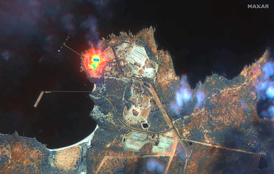
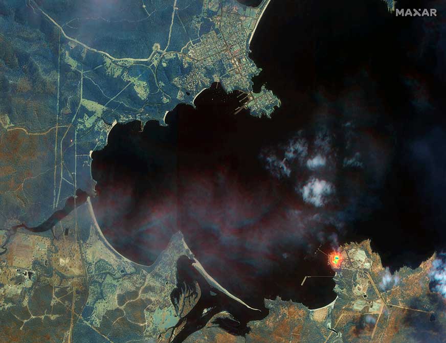
Maxar collected satellite imagery Jan. 12 of the wildfires in New South Wales (NSW). The imagery shown below focuses on the area near the town of Eden, and demonstrates the value of the shortwave infrared (SWIR) sensor.
In an image taken with Maxar’s normal RGB color imagery, the smoky air prevents a clear view of the fires and the hot spots. With Maxar’s WorldView-3 satellite, however, the team is able to penetrate through the smoke using its SWIR sensor for a detailed look at the fire lines and burned vegetation.
With SWIR imagery, burning areas are apparent and show up in a glowing orange-red. Healthy vegetation shows up in shades of blue, and burned vegetation appears in shades of brown.
Satellite Photo: :ESA
Copernicus Sentinel-3 imagery
Europe’s Copernicus Sentinel-3 mission has captured the multiple bushfires burning across Australia’s east coast.
In the above image, captured on Nov. 12, 2019, at 23:15 UTC (Nov. 13, 09:15 local time), the fires burning near the coast are visible. Plumes of smoke can be seen drifting east over the Tasman Sea. Hazardous air quality owing to the smoke haze has reached the cities of Sydney and Brisbane.
Flame retardant was dropped in some of Sydney’s suburbs as bushfires approached the city center, and many residents were evacuated. Firefighters continue to keep the blazes under control.
The Copernicus Emergency Management Service – Mapping was activated to help respond to the fires. The service uses satellite observations to help civil protection authorities and, in cases of disaster, the international humanitarian community, respond to emergencies.
Quantifying and monitoring fires is fundamental for the ongoing study of climate, as they have a significant impact on global atmospheric emissions. Data from the Copernicus Sentinel-3 World Fire Atlas shows that there were almost five times as many wildfires in August 2019 compared to August 2018.
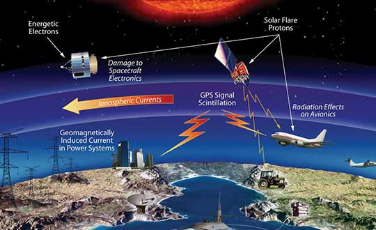
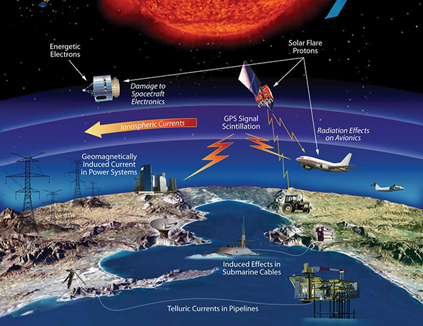
The U.S. House Committee on Science, Space and Technology has approved legislation to coordinate federal government space weather research. Included in the bill is a finding that space weather adversely affects space-based position, navigation and timing (PNT).
‘‘The effects of severe space weatheron the electric power grid, satellites and satellite communications and information, aviationoperations, astronauts living and working in space, and space-based position, navigation, and timing systems could have significant societal, economic, national security and health impacts.”
If passed, the bill would mandate coordination of government space weather forecasting and related operations, with input from academia, international groups and commercial firms affected by space weather.
The Promoting Research and Observations of Space Weather to Improve the Forecasting of Tomorrow (PROSWIFT) Act was introduced in November by Democrat Ed Perlmutter of Colorado and Republican Mo Brooks of Alabama, reports Space News. Similar legislation, the Space Weather Research and Forecasting Act, was approved in April by the Senate Commerce, Science and Transportation Committee.
PROSWIFT calls for the National Science and Technology Council to establish an interagency working group on space weather that includes the National Oceanic and Atmospheric Administration (NOAA), NASA, the National Science Foundation, Defense Department and Interior Department. It directs members of the interagency working group to collaborate with the international community, academia and the commercial space weather sector.
PROSWIFT also tasks NOAA with establishing a space weather advisory group with members representing academia, the commercial space weather sector and space weather data customers.
The U.S. Department of Transportation on Wednesday released updated guidelines for autonomous vehicles.
“Ensuring American Leadership in Automated Vehicle Technologies: Automated Vehicles 4.0” (AV 4.0) was announced by U.S. Transportation Secretary Elaine L. Chao in a keynote speech at CES 2020 in Las Vegas.
AV 4.0 unifies efforts in automated vehicles across 38 federal departments, independent agencies, commissions and executive offices, providing high-level guidance to state and local governments, innovators and stakeholders on the U.S. government’s approach toward autonomous vehicles.
“AV 4.0 will ensure American leadership in AV technology development and integration by providing unified guidance for the first time across the federal government for innovators and stakeholders,” Chao said.
AV 4.0 establishes federal principles for the development and integration of automated vehicles, consisting of three core focus areas: prioritize safety and security, promote innovation, and ensure a consistent regulatory approach.
It also outlines ongoing administration efforts supporting autonomous vehicle technology growth and leadership, as well as opportunities for collaboration including federal investments in the sector and resources for innovators, researchers and the public.
“AV 4.0 brings all of the important work happening on automated vehicle technologies across the federal government under one unified approach. The federal principles released today help foster an environment for innovators to advance safe AV technologies, and put the U.S. in a position of continued leadership in the future of transportation,” said U.S. Chief Technology Officer Michael Kratsios.
The USDOT is preparing for emerging technologies by engaging with new technologies to address legitimate public concerns about safety, security and privacy without hampering innovation, the department said in a press release.
With the release of “Automated Driving Systems 2.0: A Vision for Safety” (ADS 2.0) in September 2017, the USDOT provided voluntary guidance to industry, as well as technical assistance and best practices to states, offering a path forward for the safe testing and integration of Automated Driving Systems.
In October 2018, “Preparing for the Future of Transportation: Automated Vehicles 3.0” (AV 3.0) introduced guiding principles for autonomous vehicle innovation for all surface transportation modes, and described the USDOT’s strategy to address existing barriers to potential safety benefits and progress.
“AV 4.0 builds on these efforts by presenting a unifying posture to inform collaborative efforts in automated vehicles for all stakeholders and outlines past and current federal government efforts to ensure the United States leads the world in AV technology development and integration while prioritizing safety, security, and privacy and safeguarding the freedoms enjoyed by Americans,” the press release stated.
AV 4.0 will be published in the Federal Register for public review and comment. More information on the USDOT’s work on automated vehicles can be found at https://www.transportation.gov/av/4.
The U.S. Department of Transportation awarded contracts to 11 companies to demonstrate their technologies’ ability to act as a backup for GPS.
We wanted to know a bit more about what each of them were going to demonstrate, so we asked each for an explanation. Most provided just that, so much of what appears here is in their own words. A couple of companies sent us a whole lot more than 100 words and two did not respond. For those, we did our best with the materials they sent us and other publicly available materials.
Wi-Fi, Cellular, Ultra-Wideband
PhasorLab plans to demonstrate its Hyper Sync Net (HSN) technology as a backup to GPS-based PNT solutions. HSN is a self-organizing mobile mesh network capable of maintaining high-precision time (<<1 ns) and frequency (<<1 ppb) synchronization throughout the whole network as well as an instantaneous 3D locational map of the whole mesh network requiring as little as a single master reference node.
The HSN can be deployed either as a set of fixed reference nodes providing time and positioning references to other mobile UE clients, which is like a terrestrial version of GPS, or as a private ad-hoc mobile mesh network where all members are expected to be mobile.
Skyhook Technology’s system is powered by an immense database — created and maintained by Skyhook — that contains more than five billion geolocated access points and 200 million cell base station IDs, enabling it to accurately locate phones and devices worldwide. The user is not required to be connected to a Wi-Fi network for the system to work. The scan will simply detect Wi-Fi access points in the local area based on signals sent periodically (or on demand) according to the IEEE 802.11 specifications. Many devices will acquire information on as many as 100 access points in the surrounding area. Skyhook’s Wi-Fi positioning system (WPS) will compute an estimated end-user location based on each of the signal sources independently, and compute an optimal hybrid location estimate from all sources.
Fiber/Network
OPNT’s Global Terrestrial Timing Service (GTTS) provides GPS-independent timing-as-a-service over global fiber-based networks. Trading off cost versus service-level agreement (SLA)-backed accuracy, standard network connectivity offerings and bidirectional fibers are combined to meet application needs. As will be demonstrated with simulations of National Institute of Standards and Technology (NIST) and the two U.S. Naval Observatory (USNO) clocks, OPNT’s fully redundant solution receives its core Coordinated Universal Time (UTC) timing directly from the non-maskable interrupts (NMIs).
The demonstration will include sub-nanosecond stability with fault detection and glitchless recovery. Using the precision-timed fiber base, OPNT will also demonstrate precision monitoring of wireless signals with continuous, real-time corrections to keep the wireless transmissions and its local timing source in sync.
Seven Solutions’ core technology is called White Rabbit and was born at CERN. In this demonstration, Seven Solutions plans to showcase the performance of this technology, both on local and wide-area deployments, and explain the capabilities in terms of interoperability (integrating multiple synchronization technologies, i.e. IEEE 1588 PTP, NTP, PPS, 10-MHz clocks), scalability and resiliency. The goal is to provide a reference technology that can provide very stable time references over fiber in GPS-denied scenarios as a backup source or to complement other PNT solutions that need timing distribution at their core.
eLoran
Hellen Systems’ team said it is excited by its recent contract award to perform a GPS back-up demonstration for the Department of Transportation. Its team plans to demonstrate advanced eLoran technologies and offer resilient PNT services. Its next-generation solution will include a solid-state eLoran transmitter from Continental Electronics Corp. integrated with advanced timing and frequency products from Microsemi, a Microchip company. Hellen Systems also plans to deploy its proprietary receiver and reference systems developed by Microsemi.
Hellen Systems and program integrator L3Harris will manage the demonstration, with Booz Allen Hamilton providing technical and engineering leadership.
UrsaNav supplies eLoran, LFPhoenix and low-frequency technology for very wide-area, GPS-independent, PNT data and frequency services. UrsaNav was selected by the Volpe Center to demonstrate wide-area UTC time synchronization and distribution utilizing the former Loran site in Wildwood, New Jersey. UrsaNav will provide innovative new eLoran technology at the site in Wildwood to broadcast a UTC-synchronized eLoran signal. The demonstration will be conducted at one of the Volpe Center demonstration sites at Joint Base Cape Cod in Massachusetts or the Langley Research Center in Langley, Virginia. Either site can be utilized in the demonstration as eLoran signal transmissions from the Wildwood site can easily cover 700 miles or more.
Serco recently acquired Alion’s Naval Systems Business unit. This included a group working in New London, Connecticut, that has previously worked with and published on eLoran. While we did not get a response from Serco to our inquiry, eLoran is likely the technology the company will demonstrate.
Satellite
Globalstar-Echo Ridge’s system is based on Augmented Positioning System (APS) technology that uses ordinary signals from communications satellites (not special positioning/navigation signals, such as those from GPS satellites) to produce accurate position and timing information in compatible user devices. No new infrastructure is needed; Globalstar’s constellation of 24 low-Earth-orbit (LEO) satellites and Echo Ridge software and compatible devices at the user end provide the building blocks for the APS-based system. APS technology has been successfully demonstrated in diverse environments and incorporates multiple features to assure accurate PNT information under circumstances that can challenge or disable GPS/GNSS technology.
Satelles provides unique timing and location solutions delivered over the Iridium constellation of 66 LEO satellites. These timing and location signals are available anywhere on Earth without the need for local infrastructure, making the system perfect for complementing GPS and other location-based technologies.
Unlike standard GPS, these high-power signals can reach into many building structures. Most importantly, Satelles has customized the Iridium signal-in-space to provide a location-specific signature that can reliably prove (or authenticate) the location of a mobile device or other equipment, while being virtually impervious to spoofing and other attacks.
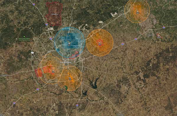
TRX Systems’ NEON Personnel Tracker provides ubiquitous 3D location, tracking and mapping. (Screenshot: TRX Systems)
Other
TRX Systems is the developer of NEON GPS-denied location solutions, delivering 3D location and mapping for dismount personnel where GPS is not available or is unreliable — including indoors, underground, in dense urban areas, and where GPS is found to be erroneous. NEON delivers ubiquitous, low-cost, GPS-denied location by using advanced sensor fusion, ranging and patented dynamic mapping algorithms that improve safety and situational awareness for military, public safety and industrial personnel.
NextNav’s Metropolitan Beacon System (MBS) is a 3GPP-compliant, terrestrial network of long-range broadcast beacons, transmitting a “GPS-like” signal in licensed spectrum in the sub-GHz range. The combination of an on-board atomic clock and the ability to self-synchronize allows the system to operate independent of GPS and provide full PNT services in its footprint. The ability to integrate the MBS signal in mass-market GPS and LTE chipsets can provide a seamless ability to provide full PNT services in the presence and absence of GPS. Because of its terrestrial nature, MBS is able to work indoors, in urban environments and outdoors; for barometer-equipped devices, MBS also enables floor-level altitude determination.
A roundup of recent products in the GNSS and inertial positioning industry from the January 2020 issue of GPS World magazine.
OEM
Heavy-duty antenna
For challenging environments
AT311 antenna. (Photo: CHC Navigation)
The heavy-duty CHCNAV AT311T is designed for demanding applications subject to shocks and vibrations. With advanced filtering and robust signal tracking, it provides survey-grade GNSS signals to enhance position reliability for marine applications, machine control, precision agriculture and industrial automation. Features include multi-constellation GNSS tracking using GPS, GLONASS, BeiDou, Galileo, QZSS, IRNSS and SBAS. Its IP68 water-resistant design makes it safe to use in extreme conditions with a wide temperature range (–40° C to +85° C). Its internal stacked structure enhances performance in high-interference environments, and the 40-dB signal gains, advanced signal filtering and multipath rejection design provide superior and robust GNSS signal tracking in challenging surroundings.
The UAS1 GNSS receiver module has been designed for UAV/UAS applications requiring centimeter accuracy in a small package.(Photo: Trimble)
The UAS1 compact, high-precision GNSS board was designed for unmanned aerial systems (UAS). It allows UAS system integrators to add upgradeable GNSS-based positioning using rugged connectors and Trimble’s software interface. Its 336-channel GNSS engine is capable of tracking L1/L2 frequencies from GPS, GLONASS, Galileo and BeiDou for centimeter-level, real-time kinematic (RTK) positioning. The compact board provides capabilities from high-accuracy GPS-only to full GNSS features. The receiver supports fault detection and exclusion (FDE) and receiver autonomous integrity monitoring (RAIM). System integrators also have the ability to detect interference with an RF spectrum monitoring and analysis tool embedded in the receiver.
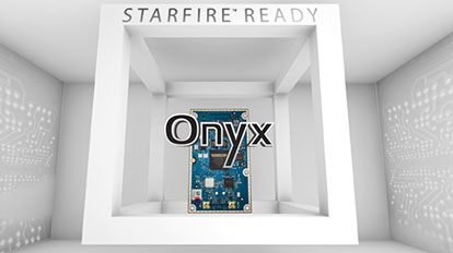
The Onyx multi-frequency GNSS OEM board offers integrated StarFire/real-time kinematic (RTK) GNSS capabilities. It features 255-channel tracking, including multi-constellation support for GPS, GLONASS, BeiDou and Galileo. It provides high performance in GNSS receiver sensitivity and signal tracking as well as patented multipath mitigation, interference rejection and anti-jamming capabilities. Through software options, the Onyx ,allows upgrades from free differential GPS signal sources such as WAAS, to increased accuracy services such as StarFire and RTK Extend. The software-enabled features are sold in bundles, but can also be purchased individually to suit changing application needs.
The OSA 5401 and OSA 5405 now enable power utility and broadcast networks to achieve sub-microsecond synchronization. (Photo: Business Wire)
The OSA 5401 and OSA 5405 upgraded PTP grandmaster clocks deliver precise, robust timing in a compact form factor. Oscilloquartz PTP timing technology enables power utility and broadcast networks to achieve sub-microsecond synchronization. The pluggable OSA 5401 is a small PTP grandmaster clock, and the OSA 5405 is an integrated PTP grandmaster with dual GNSS antenna and receiver. With spoofing and jamming detection capabilities, they also provide high availability. The OSA 5401 and 5405 provide new levels of accuracy and resilience for infrastructure and support emerging bandwidth-intensive, latency-sensitive applications. With sub-microsecond synchronization, smart grids can perform flexible, real-time decision making, as well as monitoring and automated maintenance. The OSA 5401 and OSA 5405 comply with the latest PTP profiles for time, frequency and phase synchronization in both power utility and broadcast networks. These include the IEC/IEEE 61850-9-3 Power Utility Profile for precise time distribution and clock synchronization in electrical grids with an accuracy of 1μs, and SMPTE 2059 for synchronizing video and audio equipment over packet networks.
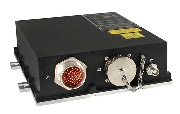
The SBAS-capable CMA-5024 GPS has received U.S. Federal Aviation Administration (FAA) approval for installation on Boeing 737 Next-Generation aircraft. It enables B737NGs to comply with worldwide ADS-B Out mandates as well as SBAS/GPS navigation, enabling the first localizer performance with vertical guidance (LPV) approaches for B737NGs. The CMA-5024 GPS is a cost-effective alternative to replace a multi-mode receiver (MMR). The approved DO-260B ADS-B Out positioning source can be paired with any DO-260B compliant transponder, allowing operators to meet FAA and EASA ADS-B Out requirements, the UAE’s ADS-B Out and RNP requirements mandated by GCAA as well as India’s GAGAN requirements.
The U.S. Federal Aviation Administration (FAA) has approved the VTU-20 automatic dependent surveillance – broadcast (ADS-B) transmitter for airport surface management. Adhering to the performance and design assurance specifications of FAA-E-3032, the externally mounted VTU-20 ensures integration and interoperability with Airport Surface Detection Equipment, Model X (ASDE-X), Airport Surface Surveillance Capability (ASSC) and ADS-B receiver surveillance solutions for airport. The VTU-20 can be permanently or magnetically mounted to all airside vehicles, including utility, emergency, snow-removal and maintenance equipment. Each vehicle is clearly and uniquely identified, providing an essential addition to any surface movement guidance and control system.
Skyward’s Advanced Airspace Intelligence drone airspace maps provide airspace data combined with essential ground intelligence including 3D views of key structures, transmission lines, and more than a million vertical obstacles. The platform also provides access to LAANC, the Low Altitude Authorization and Notification Capability program provided by the U.S. Federal Aviation Administration. Data available for situational awareness includes vertical structure obstacles, power lines, airports, runways, national parks, stadiums, hospitals and schools.
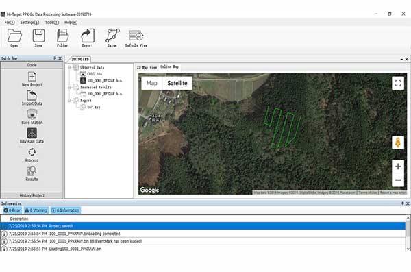
Hi-Target PPK GO precision add-on enables Phantom 4 RTK drones to achieve the accurate and reliable camera positioning data in any coordinate system without measure targets or ground control points. With 2-centimeter accuracies on XYZ, the output text file with position information or geotagged images can be used directly in major photogrammetric mapping or 3D survey software. The add-on allows selection of GPS/GLONASS/Beidou/ Galileo L1+L2+L5 and further parameter adjustments for position calculation in the PPK process to ensure the most reliable and accurate camera positioning even in poor single satellite system signals.
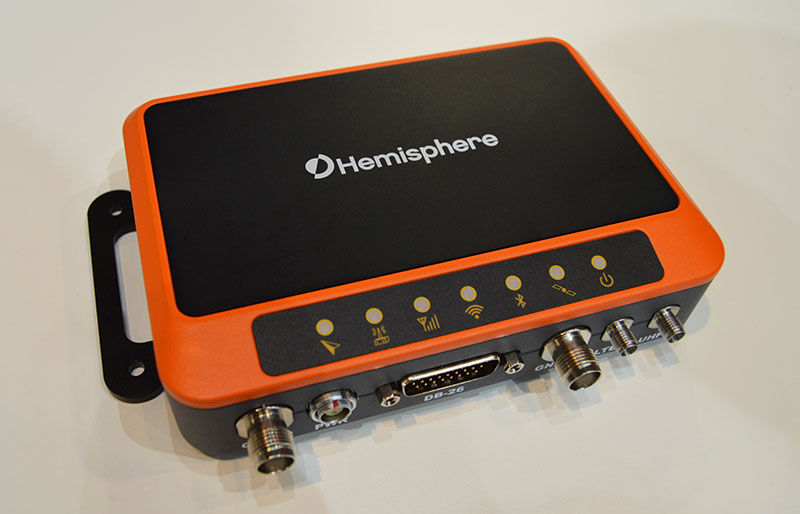
The R620 GNSS receiver is a complete refresh of Hemisphere’s previous version, the R330. (Photo: Allison Barwacz)
The next-generation R620 receiver is designed for land and marine applications requiring high-precision positioning. It is a complete refresh of the previous version (R330) and has a new low-profile ruggedized enclosure. Customers can start with sub-meter positioning accuracy and upgrade the receiver through activations and subscriptions to add functionality and improve performance capability to centimeter-level accuracy. Powered by the Vega series, the R620 GNSS receiver processes and supports more than 1,100 channels. It simultaneously tracks GPS, GLONASS, BeiDou (including Phase 3), Galileo, QZSS, IRNSS, SBAS and Atlas L-band corrections. It has status LEDs , a powerful WebUI, UHF (400-MHz and 900-MHz) radio, cellular modem, Bluetooth, Wi-Fi, Ethernet (including power over Ethernet), CAN, serial and USB.
For land surveying and geospatial information systems (GIS)
Photo: Geneq
The rugged SXPad 1500 data collector features an alphanumeric keypad and long-range Bluetooth, and was designed to meet the rigorous IP67 standard for challenging field conditions. It has a 5-inch sunlight-readable touchscreen. The SXPad 1500 can be connected to any GNSS receiver or compatible robotic total station. Driven by a 1-GHz processor and the Windows Mobile 6.5 operating system, providing the power to work with maps and large data sets in the field. Its integrated cellular modem and Wi-Fi provides wireless connectivity for internet access and GIS data transfer — helpful for configuring a real-time kinematic (RTK)-compatible GNSS receiver. Equipped with an internal memory of 1 GB (memory can be expanded to 16 GB with an SD card), the SXPad 1500 provides enough storage space for data recording. Its high-performance lithium battery allows uninterrupted field operation for up to eight hours.
The LT700H RTK Android tablet is designed to increase efficiency and productivity of the mobile field workforce in applications requiring centimeter-to-decimeter positioning accuracy. Portable, rugged and versatile, the LT700H enables precision GIS data collection, forensic mapping, construction site layout, environmental surveys, landscaping and earthmoving jobs. Powered by 184-channel high-performance GPS, GLONASS, Galileo and BeiDou module and a superior tracking GNSS helical antenna, the LT700H provides position availability in demanding environments. Its integrated 4G modem ensures seamless communication from field-to-office and robust connectivity to RTK correction networks.
The Trimble Alloy GNSS reference receiver now supports BeiDou Generation III (BDS-3) signals. This will enable operators to meet the ongoing demand from surveyors, mapping professionals and precision farmers for accurate, reliable corrections derived from real-time networks. Released in 2018, the Alloy has the processing power needed for high-quality data from multiple constellations. Alloy version 5.42 firmware tracks all available and planned GPS Block IIIA L1C and BDS-3 signals.
Hexagon showcased the Leica DSX utility detection solution at Intergeo 2019. (Photo: Allison Barwacz)
The Leica DSX utility detection solution can be used together with Leica GPS/GNSS systems to generate highly accurate, georeferenced maps. The DSX uncovers utilities for repair and maintenance, civil engineering and surveying projects. The ground-penetrating radar system includes portable hardware and software that automates data analysis and creates a 3D utility map.
DroneShield has released a vehicle-mounted drone detection and defeat product, DroneSentry-X.
Lightweight at about 10 kilograms, it can be easily mounted on most vehicles. DroneShield expects the product to be of interest to military, law enforcement, security and VIP the markets. The product is suitable for both vehicle/convoy and fixed site installations. The product was developed in response to substantial customer interest, according to the company.
“Vehicle market for counterdrone protection is rapidly rising,” said DroneShield’s CEO Oleg Vornik. “In addition to catering for that segment, DroneSentry-X provides a more affordable detect-and-defeat solution for price-sensitive customers as an alternative to purchasing full-functionality DroneSentry product from us. DroneShield offers a complete suite of detection and defeat solutions to our customers, and this new product covers the customer need which we identified in our recent engagements.”