Author: Tracy Cozzens

  • Directions 2020: BeiDou in the new era of globalization

    Directions 2020: BeiDou in the new era of globalization

    Yang Changfeng, Chief Architect, BeiDou Navigation Satellite System. (Photo: BeiDou)
    Yang Changfeng, Chief Architect, BeiDou Navigation Satellite System. (Photo: BeiDou)

    By Yang Changfeng
    Chief Architect,
    BeiDou Navigation Satellite System

    As one of the core Global Navigation Satellite Systems (GNSS) providers, the BeiDou Navigation Satellite System (“BDS”) has been developed steadily following a three-step strategy. BDS has been providing global services since the end of 2018. By around 2020, the BDS-3 system will be entirely completed to provide global users with free, open and high-quality navigation, positioning, timing, short message communication and other services. A more ubiquitous, integrated and intelligent positioning, navigation, timing system will be built before 2035.

    In 2019, BDS has progressed with regard to aspects of system construction, integrated applications and international development.

    System Construction

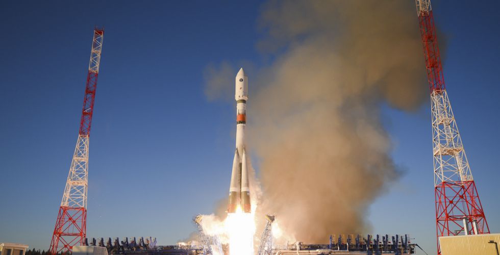
    Accelerating Satellite Deployment. From January to November 2019, three BDS-3 satellites in inclined geosynchronous satellite orbit (IGSO) and four satellites in medium Earth orbit (MEO) were launched, and one IGSO satellite has completed in-orbit tests, to further improve the global system constellation.

    The last two MEO satellites are planned to be launched by the end of 2019, marking the completion of the BDS core global constellation deployment. By June 2020, another two GEO satellites will be launched, and the full deployment of the BDS-3 system will be completed.

    Ground System Construction. In 2019, 12 new ground operation and control stations (including one uplink station and 11 class-II monitoring stations) have been built, to complete the satellite-ground joint debug and integration tests, and the overall operation of the system is stable.

    By the end of October 2019, 34 BDS satellites are operating in orbit to provide services to global users, including 15 BDS-2 satellites and 19 BDS-3 satellites.

    Improving Service Performance

    Key Service Areas. In May 2019, the last BDS-2 backup satellite was launched to further improve the performance in the key service areas of the BDS-2 system. As the BDS-3 satellites go into operation, the accuracy and availability of the BDS B1I and B3I signals, in the BDS-2service area, has been improved by about 30% and 5% respectively, compared with that of solely relying on the BDS-2 system.

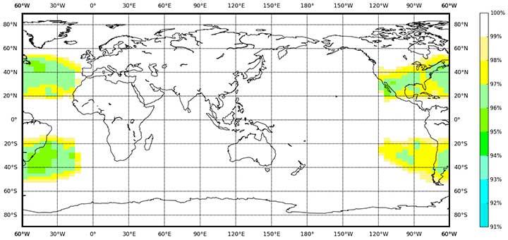
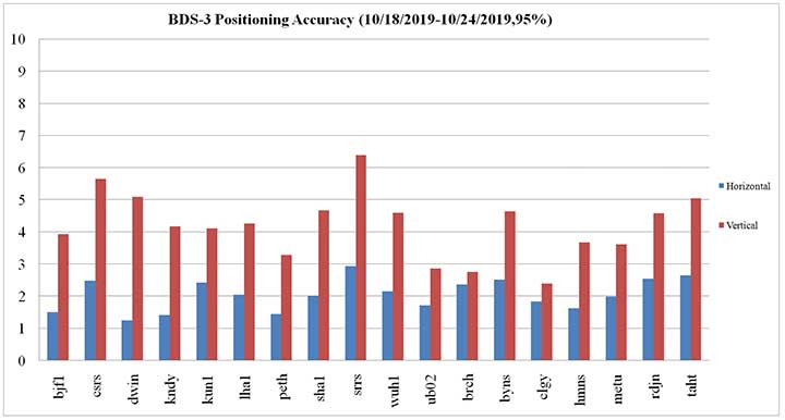
    Global Service Areas. The BDS B1I and B3I service areas have been expanded from the Asia Pacific region to the world, and the accuracy and availability have been further improved. With the condition of PDOP ≤6, the availability is better than 99% in most regions all over the world (in parts of the United States, better than 97%). In the global area, the mean value of the actual measured positioning accuracy is about 3.6m horizontally and 6.6m vertically, velocity measurement accuracy is about 0.05m/s, and timing accuracy is about 9.8 nanoseconds (95% confidence). So far, the BDS-3 new signals, B1C and B2a, have possessed service capacity worldwide. The system availability is better than 87%, in the condition of PDOP ≤ 6. The mean value of the actual measured positioning accuracy is about 2.4m horizontally and 4.3m vertically, velocity measurement accuracy is about 0.06m/s and timing accuracy is about 19.9 nanoseconds (95% confidence).

    BDS Availability (PDOP≤6). (Image: BeiDou)
    BDS Availability (PDOP≤6). (Image: BeiDou)
    Measured BDS B1C Positioning Accuracy. (Image: BeiDou)
    Measured BDS B1C Positioning Accuracy. (Image: BeiDou)

    Building of the Featured Capacity. The BDS/GNSS ground based augmentation system has been providing basic services. It consists of 155 framework reference stations and nearly 2,200 regional stations in China. The system has carried out high-precision applications in many fields, such as surveying and mapping, land resources, earthquake, transportation and meteorology. Its basic services include real-time positioning at the meter, decimeter and centimeter level, as well as precise post-processing positioning at the millimeter level.

    The BeiDou Satellite-Based Augmentation System (BDSBAS) is being developed in accordance with International Civil Aviation Organization (ICAO) standards to provide navigation services with superior accuracy and integrity. In 2019, the first GEO satellite with the BDSBAS payload has been tested in orbit and the satellite is in good condition.

    Integrated Applications

    As the system construction accelerates, BDS is also making great efforts to strengthen the development of the fundamental products and applications in various fields. The integrated applications adopt the “BDS+” model to stimulate the growth of satellite navigation industry.

    Fundamental Products. At present, the fundamental BDS products have been used in such areas as mass market applications, of which the performance has reached or is close-to the world-class level. The development of full-frequency integrated high-precision chips is near its completion, and the performance of the BDS chips will improve further. By the end of 2019, BDS navigation chips, modules and antennas have been exported to more than 100 countries and regions. In 2018, the domestic output value was more than RMB 300 billion (US$43 billion), in which the BDS contribution exceeds 80%.

    Industrial Applications. BDS has been widely used in various fields — communication and transportation, public security, agriculture, forestry, animal husbandry and fishery, hydrological monitoring, meteorological forecast, time synchronization, power dispatching, disaster prevention and mitigation — generating significant economic and social benefits. In the field of transportation, by September 2019, more than 6.47 million road operating vehicles and 42,300 postal and express delivery vehicles in China are using BDS, and the world’s largest dynamic supervision system of operating vehicles has been formed, which effectively improved management efficiency and road transportation safety.

    In agriculture, a BDS-based automatic driving system has been equipped on more than 20,000 sets of agricultural machinery and equipment, saving 50% of the labor cost. The BDS-based agricultural machinery operation supervision platform and the IoT platform has been serving 10 million units of agricultural machinery equipment, greatly improving management and operational efficiency.

    In disaster prevention and mitigation, a tri-level platform covering the national ministry, the provinces, and cities and counties has been built to offer six-tier application services, with more than 45,000 terminals using BDS. The BDS/GNSS high-precision technologies have been applied in the field of geological disaster monitoring, while the landslides in Gansu province have been successfully forecast repeatedly, with time accuracy at the second level and deformation accuracy at the millimeter level.

    Mass Market Applications. The BDS-based navigation and positioning services have been adopted by various enterprises in the fields of e-commerce, smart mobile terminal manufacture, location-based services (LBS), the sharing economy and the mass market, thereby changing people’s production and life style profoundly. Mainstream manufacturers in China and around the world have introduced BDS-compatible chips that integrate communication and navigation functions.

    According to Chinese market statistics, in the third quarter of 2019, 151 types of mobile phones applying for license have positioning functions, among which 110 models support BDS. Using BDS/GNSS ground based augmentation stations, the spatial-temporal services including centimeter-level positioning, millimeter-level perception and nanometer-level timing services can be provided, while the accelerated positioning services cover 220 countries and regions with more than 390 million global users.

    International Development

    Bilateral Cooperation. BDS continues to carry out bilateral cooperation with other navigation satellite systems, to promote compatibility and joint applications. China and the United States have set up joint working groups in areas such as compatibility and interoperability, augmentation systems and civil services to continuously develop cooperation and exchanges.

    China and the EU set up a technical working group on the compatibility and interoperability between the BDS and Galileo systems to carry out coordination, exchanges and cooperation, under the framework of the China-EU space cooperation dialogue and the International Telecommunications Union (ITU). The agreement between the Government of the People’s Republic of China and the Government of the Russian Federation on Cooperation in the Field of the Use of BeiDou and GLONASS for Peaceful Purposes has come into effect.

    In August 2019, China and the Russian Federation held their sixth bilateral meeting in Kazan, Russia, signed the site survey certificate of GNSS monitoring stations, and achieved many cooperation results. In addition, the bilateral cooperation with Iraq, Tunisia and Saudi Arabia has also been steadily promoted.

    Multilateral Cooperation. During the 62nd session of the Committee on the Peaceful Uses of Outer Space (COPUOS) in June 2019, an exhibition on ancient Chinese navigation technologies was held at the Vienna International Center with the theme “From Compass to BeiDou,” which vividly demonstrated China’s brilliant achievements in timing, mapping, cartography and navigation science and technology. In April and October, 2019, the second China-Arab States BDS Cooperation Forum and China-Central Asia BDS cooperation forum were held in Tunis and Nanning, China, respectively, to promote the BDS to serve the Arab region and Central Asian countries.

    The BDS Overseas Applications Were Steadily Promoted. With BDS high-precision products being exported, BDS has been widely used in different regions and fields, such as land registration, precision agriculture, warehouse logistics in ASEAN countries, construction in Western Asia, airport timing and piling at seas in South Asia, electric power inspection in Eastern Europe, and land survey in African countries. As BDS-3 system continues to improve construction, it will provide quality services for more people in a wider area.

    Ratification of BDS by International Standards. BDS has made a clear schedule to be ratified by the ICAO standards in 2020. It has formulated 26 standards in the field of international mobile communication based on the BDS B1I signal, and other standards based on the B1C and B2a signals are being developed. A receiver positioning result output protocol (NMEA0183) and a receiver data exchange format (RINEX 3.04) supporting BDS are to be released. Technical parameters and index information of BDS search and rescue (SAR) payloads are included in relevant COSPAS-SARSAT documents, and the development and in-orbit test of the first batch of SAR payload has been completed. The first BDS standard in the International Electrotechnical Commission (IEC) has been developed and approved and is expected to be released in June 2020.

    Future Plans

    After BDS achieves global service capabilities by 2020, it will further improve global navigation, positioning, timing and regional short-message communication services, and finalize global short-message communication, international search and rescue, satellite-based augmentation, precise point positioning, and other service capabilities. China’s BDS will contribute Chinese solutions to the world, and give full play of its role, with a renewed attitude, stronger capabilities and better services, to serve the world and benefit humankind.

  • Directions 2020: Delivering GPS capabilities

    Directions 2020: Delivering GPS capabilities

    By Colonel John Claxton
    Chief, PNT Mission Integration, Air Force Space and Missile Systems Center

    Image: USAF
    Image: USAF

    The Global Positioning System has provided the citizens of the United States and the world the gold standard for positioning, navigation and timing (PNT) for the past 40 years. These days, GPS is seamlessly integrated into our daily lives in ways that we hardly notice. In fact, most of us expect GPS to be available in much the same way that our lights come on when we flip a switch or water comes out when we use the kitchen faucet.

    None of this is easy, however, and wouldn’t happen if it wasn’t for the incredible work and communication by the members of the GPS Program Office and our terrific enterprise partners. During the next 18–24 months, the GPS enterprise will deliver the new and more powerful modernized GPS III capabilities across all segments of the system, which have been in the works and promised for the past 8–10 years. As we transition to the Space and Missile Systems Center’s (SMC) 2.0, this is a very exciting time for the GPS program. Below are some updates on our major programs.

    Program Updates

    GPS III. The space segment of modernized GPS has reached our goals from 2018, and then some. SV01 “Vespucci” launched on Dec. 23, 2018, heralded by celebrations across the GPS community. The GPS III team was honored to share this event with so many giants of the GPS world. We completed space vehicle (SV) 01’s On-Orbit Checkout Test in July, meeting and exceeding all performance objectives, and plan to transfer SV01 Satellite Control Authority from SMC to the 14th Air Force by the end of the year. SV01 then begins operational testing and is expected to be certified for full operations in April 2020.

    SV02 “Magellan” launched on Aug. 22 aboard a United Launch Alliance Delta IV Medium rocket — the last Delta of its class — to much fanfare and celebration as well. We completed SV02 orbit raising and initial checkout in early September, and Magellan is next in line to transition to operations in 2020.

    We received delivery of SV03 and SV04 from Lockheed Martin Space Systems on May 16 and Sept. 10, respectively, with launches targeted for March and July 2020.

    Challenges remain — this business is hard — but the GPS III team is focused on delivering capability: improving and streamlining the largest big-satellite production line in the Department of Defense and driving our launch campaign to bring modernized capabilities, higher power performance, and the shared international L1C signal to the GPS-using world.

    Figure 1. Mature Glonass-M satellites show improved cesium frequency standards performance in terms of daily stability. (Image: Roscosmos)
    Figure 1. Mature Glonass-M satellites show improved cesium frequency standards performance in terms of daily stability. (Image: Roscosmos)

    GPS IIIF. The GPS III Follow-On program looks to continue the success of GPS III as it moves forward in production of the first two GPS IIIF satellites. The program is well into a year-long set of detailed design reviews projected to conclude in March 2020. With Lockheed Martin as the prime contractor for both GPS satellite programs, GPS IIIF can take advantage of production-line improvements learned from GPS III to significantly reduce assembly, integration and test timelines.

    Additionally, the program is helping to shape SMC’s Enterprise Commonality Initiative: an effort focused on aligning common products and processes across multiple programs to improve quality, speed up delivery and lower costs. With plans to procure 22 satellites and a delivery timeline spanning 15 years, the program has implemented a technology-insertion strategy and partnered with the Air Force Research Laboratory to ensure a timely transition of new capabilities to meet future military requirements. It is great to see the progress GPS IIIF is making in delivering its new baseline capabilities along with the steps it’s taking toward future capability insertion. The first GPS IIIF satellite launch is forecast for 2026.

    GPS Next Generation Operational Control System (OCX). This past year, we used OCX Block 0, also known as the GPS III Launch and Checkout System, to launch and initialize both GPS III SV01 and SV02 and have been flying them in caretaker status until they are ready to be incorporated into the operational constellation. On OCX Block 1, all coding is complete, and the program focus is transitioning from development to system integration, test, and then transitioning the system to operations. Program investments over the past couple of years to change the program culture and modernize the factory infrastructure (often referred to DevOps) is paying off and yielding real-time metrics used to make data-driven decisions and produce higher quality code at a significantly faster rate. As a result, OCX is no longer troubled, but is now a typical large-complex software-intensive program that will experience challenges and risks. Fortunately, the right tools are in place to deliver this critical capability.

    GPS Legacy Ground Sustainment. We continue to sustain our existing GPS infrastructure associated with the current Operational Control System (OCS). These sustainment efforts ensure GPS will continue to deliver the gold standard in PNT while providing the crucial on-ramp to incorporate the next generation of modernized GPS capabilities. We operationally accepted the largest OCS upgrade in GPS history. This upgrade, known as Version 7.5, virtualized the network, implemented two-factor authentication, secured connections to worldwide ground antennas, and improved encryption for mission data.

    Challenged with a need to rapidly mitigate mission risk and provide enhanced cyber protection, the Red Dragon Cybersecurity Suite (RDCSS) emerged as the GPS OCS monitoring platform, providing data aggregation, analytics and multi-level Indicators of Compromise (IOC). It has evolved into an efficient and effective means to detect, investigate, and report security events and incidents.

    Additionally, in August 2019 we established an RDCSS connection into the Space Enterprise Defensive Cyber Operations (DCO) solution, known as the Cyber Defense Correlation Cell for Space. This created a layered defense and a tiered DCO environment for protecting and sustaining the GPS mission.

    GPS User Equipment. Over the past year our soldiers, sailors, marines and airmen continued testing and integrating mature, next-generation GPS receiver cards that provide more accurate and reliable positioning, navigation and timing. The first

    Military GPS User Equipment (MGUE) receiver card was qualified this year, and the core technologies are being leveraged to develop many other types of GPS receiver cards for a wide range of DoD weapon systems. This exciting work is the culmination of nearly two decades of modernization efforts throughout the GPS enterprise.

    In the near term, we are utilizing M-code-capable lead platforms — the USAF B-2 Bomber, USMC Joint Light Tactical Vehicle, USN Arleigh-Burke Class Guided Missile Destroyer and Army Stryker combat vehicle — to prove those capabilities. The second increment of MGUE now underway will focus on requirements for precision-guided munitions, a joint common modular handheld unit, as well as circuit cards and components for low size, weight and power needs. With MGUE, the DoD and services are poised to have enduring PNT solutions the warfighter can leverage for years to come.

    GPS Integration Roadmaps

    Integration of modernized GPS III capabilities into our major programs is a key focus of the GPS Program Office as we deliver capabilities to our warfighter and civilians users. We have continued to refine our plans and further integrate our programs and teams to ensure a seamless transition and continued high level of service.

    Enterprise Road to Launch (ERTL). The Road to Launch team achieved an historic victory of firsts in December 2018. We successfully launched GPS III SV01, the first of its class. SMC partnered with SpaceX to launch SV01 aboard a Falcon 9 rocket — their first National Security Space Launch. SV01 reached orbit under the command and control of our first GPS OCX delivery, the GPS III Launch and Checkout System.

    This colossal accomplishment of firsts was only possible because of the exceptionally close integration, tenacity and highly collaborative effort among all players in the community — spacecraft, payloads, launch, control, signal monitoring, acquisition, operations, test and many others. For SV01, the ERTL has now passed the torch to the Enterprise Road to Mission team — but the Road to Launch team is as busy as ever.

    The mission planners, launch and orbital operations crew ensured SV02 reached medium Earth orbit with needle-threading precision in August; the team is implementing improvements based on experience as we prepare for up to three more GPS III launches in 2020; and we are already ramping up efforts to design the launch campaign for GPS IIIF.

    GPS Enterprise Road to Mission (ERM). With two GPS III satellites now on orbit, it is now time to execute the Enterprise “Integration Playbook” we have developed and coordinated over the past year. The Contingency Operations (COps) modification upgrade has now been integrated into OCS on the 2 SOPS operations floor and is undergoing Developmental Testing with the GPS III SV on orbit. The program anticipates operational testing in January 2020 and Operational Acceptance in April 2020. All of our community stakeholders are ready, and with the COps modification to OCS in place, it is time to get the GPS III satellites into mission and start providing its new capabilities to our users. Over the next few months, the GPS III capabilities are expected to be operationally certified and ready for use.

    GPS Enterprise Road to M-Code Mission (ERM-M-Code). With COps now in place, the next major delivery will be M-Code Early Use modification to OCS, installation of new M-code signal monitoring equipment at sites around the globe, modification of mission planning software, MGUE Increment 1 development, service lead platform integration efforts, and operationalization of space receivers. It is our continued objective to improve the ability of the Combined Space Operations Center, to respond to urgent PNT needs of the combatant commanders as they engage more sophisticated adversaries. We remain closely aligned with our peers at USSTRATCOM, AFSPC and our worldwide users across the Joint Service and allied team.

    Conclusion

    It has never been a more exciting time to be part of the GPS program and enterprise. Our outstanding government and contractor teams have worked so incredibly hard on integrating and communicating our programs to ensure the successful and seamless delivery of GPS III capabilities to both our warfighter and civilian users. It is a great world we live in today, and GPS makes it even better.

  • Nearmap acquires Pushpin tech for roof geometry

    Nearmap acquires Pushpin tech for roof geometry

    Figure 2: Rapid growth requires frequent imagery. Above is a new Durham neighborhood under construction. (Photo: Nearmap)
    Photo: Nearmap

    Aerial imagery company Nearmap has acquired technology and assets from Pushpin, a deep learning and analytics technology company that extracts data from 3D models to provide roof geometry insights to a variety of sectors including roofing, solar and government.

    The technology acquisition allows Nearmap to rapidly extract and disseminate roof geometry from its wide-scale 3D models and offer a new form of location content to its customers.

    ‘‘By acquiring Pushpin’s 3D geometry extraction technology and pairing it with our rich data, we bring the best of both worlds together at unprecedented scale’’ said Rob Newman, Nearmap CEO. “Over the past couple of years, we’ve evolved our offering from 2D imagery to a multi-product portfolio, and this acquisition is an important milestone in our approach to continue adding new content types for our customers. This addition aides our company mission by providing 3D geometry data at unmatched speed, thereby changing the way our customers perform their work.”

    With this new technology, Nearmap can provide a semi-automated calculation and extracted representation of any roof geometry within an hour, significantly reducing turnaround time. The combination of Nearmap’s 3D content and Pushpin’s geometry extraction technology opens up a diverse range of use cases, enabling businesses to fast-track job estimation, determine solar irradiance, plan drone delivery routes and model 5G propagation.

    “The addition of Pushpin’s 3D geometry extraction technology into our large-scale 3D reality models will enable us to further evolve our offering and produce at scale roofing geometry,” said Tom Celinski, Executive Vice President, Technology and Engineering at Nearmap. “With the added ability to provide roof geometry data, we will be able to provide even deeper insights on what’s happening on the ground, and help businesses and government organizations transform the way they work and do their job more efficiently.”

    The roofing and solar industries are poised for significant growth. Currently, 1% of the United States population has solar panels on their homes. According to the Solar Energy Industry Association (SEIA), total U.S. solar capacity will more than double over the next 5 years.

    Additionally, a significant number of U.S. residential homes have their roofs replaced every year due to roof damaging storms and changes in roofing trends and material. This new product offering from Nearmap is poised to significantly impact these markets, as companies are expanding their use of technology to assist with tasks such as roof material and project quoting through reports, project management through roofing specific software, and customized sales and marketing tools for the roofing industry.

  • Highway scanning/GNSS system moves forward in Germany

    Highway scanning/GNSS system moves forward in Germany

    Germany’s Federal Highway Research Institute (BASt) is using a specialized semi-truck to analyze and map road surfaces. The research vehicle uses GNSS, scanner and camera equipment to record the condition of road surfaces and the substance of the asphalt surface, providing the basis for optimum maintenance planning.

    The truck is part of the BASt’s MESAS program, which began in 2018. The unique measuring vehicle is a multi-functional assessment tool for fast-moving substance detection, such as for structural evaluation and design of pavements.

    For the MESAS program, innovative measurement technology was installed on a single-axle semi-trailer, with all measurement systems synchronized and georeferenced using a GNSS system.

    The MESAS measuring vehicle is 14.5 meters long and weighs 22 tons. At speeds of up to 80 km/h, MESAS records road condition parameters with high precision. (Photo: BASt)
    The MESAS measuring vehicle is 14.5 meters long and weighs 22 tons. At speeds of up to 80 km/h, MESAS records road condition parameters with high precision. (Photo: BASt)

    The vehicle includes:

    • the Pavement Profile Scanner PPS-Plus from Fraunhofer IPM
    • a laser-based Traffic Speed Deflectometer (TSD) that measures short-term reversible deformations of the road surface
    • a georadar that detects layer thicknesses and inhomogeneity of the road superstructure
    • ambient cameras that provide images for interpreting the georadar measurements

    During test runs, the vehicle system successfully measured more than 11,000 kilometers of the country’s trunk-road network. Now it begins regular operation.

    “MESAS is a globally innovative measuring system,” said Dirk Jansen, department head, BASt. “Here we have a really powerful tool at our disposal with which we can make an innovative and significant contribution to the further development of conservation planning.”

    Millimeter precision. The Pavement Profile Scanner PPS-Plus records the transverse evenness of the road surface with high precision. The scanner, the size of a shoe box, is mounted on measuring vehicles and scans the road surface with an eye-safe laser beam over a width of about 4 meters. The distance to the road surface is determined with sub-millimeter accuracy using phase-shift technology.

    The laser scans the surface with the aid of a rotating polygon mirror perpendicular to the forward movement of the vehicle and generates 800 profiles per second. Each profile consists of up to 900 measuring points, depending on the selected measuring frequency. In this way, the PPS generates a detailed 3D height profile of the road surface.

    At traveling speeds of 80 km/h, the measuring point distance in the longitudinal direction is approximately 28 millimeters; in the transverse direction it is 4.5 millimeters. It also provides photorealistic grey-scale images of the road surface that show millimeter-thin structures, such as small repairs and patches.


  • Trimble provides precision controller and display to farmers

    Trimble provides precision controller and display to farmers

    Trimble has introduced the GFX-350 display and NAV-500 guidance controller, providing a cost-effective option for farmers seeking to adopt the latest precision agriculture technology for their daily operations.

    The GFX-500 display. (Photo: Trimble)
    The GFX-500 display. (Photo: Trimble)

    The GFX-350 Android-based touchscreen is a cost-effective way to introduce auto-steering and application control to the farm. The 7-inch (18-centimeter) screen is easy to read and can be used to control most field operations with a few taps.

    The display is compatible with both the NAV-500 and the NAV-900 guidance controllers, satisfying different user accuracy needs. The simple and intuitive Precision-IQ operating system speeds up field work and makes equipment configuration a breeze. Once vehicles, fields, implements and materials are set up during the first use, they are saved and can be re-used with a couple of clicks.

    The NAV-500 controller. (Photo: Trimble)
    The NAV-500 controller. (Photo: Trimble)

    In addition, the GFX-350 display is fully ISOBUS compatible, offering plug-and-play capability for ISO-enabled implements with native task controller and universal terminal functionality. The display also features onboard Wi-Fi and Bluetooth connectivity, allowing seamless sharing of data between the office and the field via optional Trimble Connected Farm solutions. General record keeping and proof of placement reporting has never been easier.

    The NAV-500 guidance controller features a low-profile rugged housing capable of receiving signals from five different GNSS satellite constellations — GPS, Galileo, GLONASS, BeiDou and QZSS. This precision solution offers sub-meter repeatable accuracy and full-farm coverage ideal for tillage, broad-acre seeding, spraying and harvest operations.

    By using Trimble’s ViewPoint RTX satellite-delivered correction service with the NAV-500, operators can consistently achieve 15 centimeter pass-to-pass accuracy. Paired with either the new GFX-350 display or larger 10-inch (25.4-centimeter) GFX-750 display, the NAV-500 can provide roll-corrected manual guidance or can automatically control steering with the EZ-Steer assisted steering system and EZ-Pilot® Pro steering system.

    “Connectivity and interoperability are very important to the future of agriculture and Trimble has made these features a cornerstone of our product portfolio,” said Abe Hughes, general manager of Trimble’s Agriculture Division. “Customers can select from a range of hardware and software options to meet their specific needs and budget. And the true beauty of this flexible product integration is that it can grow with the farmer’s operation. Upgrades can be as simple as moving to a higher precision correction signal or using existing mounts to install a larger and more capable receiver or display. Ease of installation and operation are key with the GFX-350, which can reduce barriers to entry for farmers new to precision agriculture.”

    The GFX-350 display and NAV-500 guidance controller are designed for clean and simple installation that can typically be completed in half a day, getting farming equipment back in the field faster. The display uses a quick release RAM mount for easy transfer between vehicles, and typically requires only two cables to be attached, reducing clutter in the cab.

    Trimble’s GFX-350 display and NAV-500 guidance controller are expected to be available for order in the fourth quarter 2019 from the Trimble dealer and Vantage distribution networks.

  • Collins Aerospace joins GPS Innovation Alliance

    Collins Aerospace joins GPS Innovation Alliance

    GPS Innovation AllianceCollins Aerospace has joined the GPS Innovation Alliance (GPSIA).

    Collins Aerospace is one of the world’s largest suppliers of aerospace and defense products, and joins founding-member companies John Deere, Garmin and Trimble as well as 11 national organizations who make up GPSIA’s affiliates program.

    Collins will further bolster the Alliance’s goal of enhancing GPS innovation, creativity and entrepreneurship.

    “We are excited to welcome Collins Aerospace as the newest member of the GPS Innovation Alliance,” said GPSIA Executive Director J. David Grossman. “As one of the leading aerospace companies in the world, Collins has a long and deep history with GPS technology, beginning with the first GPS signal ever received from the roof of their facilities in Cedar Rapids, Iowa. We look forward to working with Collins Aerospace as the newest member of GPSIA and are confident that they will be a valuable addition in our efforts to heighten awareness of the economic importance and societal benefits of GPS.”

    “GPS technology is vital to Collins Aerospace, enabling us to achieve innovative solutions for the aerospace and defense industries,” said Frank Zane, associate director of Business Development, Position, Navigation, Timing (PNT), Collins Aerospace. “We are thrilled to join the GPS Innovation Alliance in their long-standing efforts to ensure the continuous availability, accuracy, reliability, and resiliency of the GPS constellation.”

    ​The GPS Innovation Alliance was founded by Deere & Company, Garmin International, Inc. and Trimble Inc. The alliance recognizes the ever-increasing importance of  GPS  and other GNSS technologies to the global economy and infrastructure and is firmly committed to furthering GPS innovation, creativity and entrepreneurship.

  • Russia successfully launches Glonass-M satellite

    Russia successfully launches Glonass-M satellite

    A new Glonass-M navigation satellite is now aloft, preparing to join Russia’s GLONASS constellation.

    The satellite launched Dec. 11 at 11:54 Moscow time aboard a Soyuz-2.1b launch vehicle from the Plesetsk cosmodrome, the Russian Ministry of Defense’s Information and Communications Department said.

    The launch was initially scheduled for December 10, but was postponed for a day for technical reasons.

    Glonass-M satellites form the basis of the orbital constellation of the GLONASS system. They provide navigation information and accurate time signals to land, sea, air and space consumers.

    The Ministry of Defense noted that pre-launch operations and the launch of the rocket were normal. “Means of the ground-based automated spacecraft control complex of the Russian orbital group controlled the launch and flight of the rocket,” the military department said.

    The Fregat booster unit was manufactured by NPO Lavochkin (part of Roscosmos State Corporation.) The Glonass-M navigation satellite was produced by ISS Reshetnev (Reshetnev Information Satellite Systems).

  • J-Shield filters out interference

    J-Shield filters out interference

    The Triumph-LS receiver. (Photo: JAVAD GNSS)
    The Triumph-LS receiver. (Photo: JAVAD GNSS)

    J-Shield is a robust filter on Javad GNSS antennas that blocks out-of-band interference (Figure 1). In particular, J-Shield blocks signals that are near the GNSS bands, including the proposed Ligado Networks (formerly LightSquared) broadband signals, explained Javad Ashjaee, founder and CEO of Javad GNSS.

    FIGURE 1. Protection characteristics: The J-Shield filters have a sharp 10-dB/KHz skirt, which provides up to 100-dB of protection. (Image: JAVAD GNSS)
    FIGURE 1. Protection characteristics: The J-Shield filters have a sharp 10-dB/KHz skirt, which provides up to 100-dB of protection. (Image: JAVAD GNSS)

    The anti-jam digital filters protect against in-band interference such as the harmonics of nearby TV and radio stations, or against illegitimate in-band transmissions. The anti-jam filters can be combined in pairs for complex signal processing and can simultaneously suppress several interference signals.

    “The filters make the near band spectrums available for other uses,” Ashjaee said. “They protect GNSS bands now and in the future.”

    In-Band Noise Measurement. The receiver measures the level of interference as a percentage of noise above the normal condition. Figure 2 shows the condition in a clean environment, where eight GPS satellites were visible, according to the almanac. In all, eight C/A, six P1, six P2, six L2C and two L5 GPS signals were tracked. The noise level was 2% on C/A and L5 and 0% on P1, P2, and L2C.

    FIGURE 2. Clean environment. (Image: JAVAD GNSS)
    FIGURE 2. Clean environment. (Image: JAVAD GNSS)

    Figure 3 shows 290% noise in the GPS C/A signal and 121% noise in Galileo E1. Only one of the eight GPS C/A code and none of five Galileo E1 signals could be tracked because of the high level of interference.

    FIGURE 3. High interference levels. (Image: JAVAD GNSS)
    FIGURE 3. High interference levels. (Image: JAVAD GNSS)

    Spectrum Analyzer

    Filters in the GNSS antenna provide one way to protect GNSS signals from interference. Another is the receiver chip itself. For instance, the Javad GNSS Triumph chip includes an integrated spectrum analyzer — a more efficient solution than using a commercial spectrum analyzer to continuously monitor and evaluate the environment, Ashjaee explained.

    The spectrum analyzer monitors the spectrum inside the chip. It has an effective bandwidth of 1 KHz, and can be programmed to automatically record the spectrum (and other information) periodically or according to pre-set conditions. Each spectrum shows the power and shape of any interfering signals and jammers.

    Figure 4 shows the shape of the GPS L1 band spectrum when the band is jammed, as indicated by the huge peak in the center where the C/A code is. The number on the bottom left is the height of the peak. The height of the spectrum is 21.1 dB; compared to a calm spectrum of 11.2 dB, this spectrum indicates a jamming impact of about 10 dB.

    FIGURE 4. The L1 band is jammed, as shown by the peak.
    FIGURE 4. The L1 band is jammed, as shown by the peak. (Image: JAVAD GNSS)

    Automatic Gain Control. In addition to monitoring the spectrum, the Triumph chip also keeps a record of automatic gain control (AGC) — another indicator of unwanted external signals. The AGC monitors the environment and adjusts the gain to keep the voltage at a certain level. The change in AGC is an indicator of interference.

    Spoofers

    “Spoofers are quite different from jammers,” Ashjaee said. “They don’t disturb the environment and the spectrum shape. They broadcast a GNSS-like signal to fool the GNSS receivers to calculate wrong positions. We detect spoofers by digital signal processing.”

    With 864 channels and about 130,000 fast-acquisition channels in the Triumph 2 chip, it has the resources to assign more than one channel to each satellite to find all of the signals transmitted with the same GNSS PRN code — including spoofed signals.
    “If we detect more than one reasonable and consistent correlation peak for any PRN code, we know that we are being spoofed and can identify the spoofer signals,” Ashjaee said. The chip isolates and ignores the wrong peak.

    “Usually more than 100 signals are available at any given time. We need only four good signals to compute position,” Ashjaee said. “We reject infected signals, and then among all the available GPS, GLONASS, Galileo, BeiDou, IRNSS and QZSS signals, we use the healthy ones. It is extremely unlikely that we can be spoofed without our knowledge. We can immediately recognize spoofing and take corrective actions. In the rare case that all signals are affected, we inform the user and guide them to use a compass and altimeter to get out of the jammed area.”

    Figure 5 is a screenshot from the company’s Triumph-LS survey receiver, showing the details of each signal tracked. The first six lines in this screenshot show the spoofed signals that were detected as soon as they appeared (number “1” in the C1 column). Percentages show the amount of interference above the normal level.

    In the last column, T indicates the signal was tracked by the main channels, Q by the fast-acquisition channels, and U indicates the signal was used in position calculations.

    Figure 5. Signal Details: The Triumph-LS receiver provides users with a wealth of information on each signal received, including spoofed signals.
    Figure 5. Signal Details: The Triumph-LS receiver provides users with a wealth of information on each signal received, including spoofed signals.

    Indicators for Healthy Signals

    In addition to the spectrum shape and AGC, these other indicators show the health of GNSS signals:

    • Number of signals tracked.
    • Divergence of SNR from its expected value.
    • Level of additional power and its RMS.
    • Divergence of AGC from its normal value and its RMS.
    • Extra noise.
    • Number of signals spoofed.

    As an aid to users, the company’s Triumph-LS receiver can display the status of all GNSS signals received. Figure 6 shows this compact view, with normalized values of the above indicators (0 means good and 9 means poor).

    Figure 6. Signal Status. Information on all GNSS signals received as shown by the Triumph-LS. (Image: JAVAD GNSS)
    Figure 6. Signal Status. Information on all GNSS signals received as shown by the Triumph-LS. (Image: JAVAD GNSS)

    Users of the Triumph-LS can click on any of the signal buttons to see the actual and normalized values of the indicators for that signal. Action buttons provide quick access to View Satellites, View Spoofing, View Spectrum and Take Spectrum. Jamming and spoofing protection is an option on all Javad GNSS products and OEM boards.


    See also:

    Access denied: Anti-jam technology mitigates navigation warfare threats, By Matteo Luccio
    New CRPA concept antenna designed, By Tony Murfin

  • Centauri acquires Design Knowledge and PreTalen companies

    Centauri acquires Design Knowledge and PreTalen companies

    centauri-logoCentauri, a provider of high-end space, intelligence, directed energy and cyber solutions, has acquired The Design Knowledge Co. (TDKC) and PreTalen Ltd.

    TDKC has proven capabilities in microelectronics trust and assurance, space domain awareness, and advanced visualization for enhanced situational awareness. PreTalen’s core competencies are the related practices of cyber warfare, navigational warfare, and positioning, navigation and timing (PNT) techniques and technologies in support of defense and offensive operations to counter adversaries.

    Both companies are headquartered in Dayton, Ohio.

    The acquisitions more than double the number of Centauri employees in the region to more than 300, supporting customers across the space, cyber and intelligence markets.

    In addition, to bringing TDKC and PreTalen’s capabilities to bear for Centauri’s broader customer base, Centauri is building additional research and development labs, and secure facilities in the Dayton region to expand innovation and cutting-edge solutions for Centauri’s customers.

    “Both TDKC and PreTalen have exceptional talent and share a common culture of innovation in pioneering new capabilities for the warfighter” said Dave Dzaran, CEO of Centauri. “With TDKC, we are building world-class capability to help ensure trusted microelectronics in the supply chains for the defense and intelligence communities. Their expertise in space domain awareness brings additional AI and machine learning technology to further strengthen Centauri’s existing space-related mission capabilities focused on the next generation of solutions that will serve this rapidly-evolving domain.”

    “Similarly to TDKC, PreTalen’s unique skill sets relating to all aspects of the PNT architecture serve as a true differentiator on their programs,” said Dennis Kelly, president and COO of Centauri. “PreTalen has built a critical mass of the most innovative employees in both PNT and cyber, and we are excited to facilitate collaboration not only with our Dayton operations but also across the rest of our company.”

    Greg Gerten, CEO of PreTalen, and Dan Schiavone and Eric Loomis, founders of TDKC, as well as both of their leadership teams, including Bruce Hart, will become a part of Centauri’s growing operations in the region.

    This investment in the Dayton region comes on the heels of Centauri’s hiring of Col. Elena Oberg, former vice commander of the Air Force Research Laboratory, headquartered just outside Dayton at Wright-Patterson Air Force Base.

    With the addition of TDKC and PreTalen, Centauri now has more than $475 million of annual revenues and 1,650 employees, approximately 20% of which support customers located in the Dayton market.

    “I speak for all of PreTalen when I say that we are extremely excited to be joining forces with Centauri,” Gerten said. “Our team is eager to apply our core capabilities to the space and Intelligence communities, and we look forward to replicating our past success for an ever-increasing number of customers. Furthermore, Centauri’s focus on innovation meshes well with what we’ve spent 12 years building here at PreTalen, and I’m thrilled to continue our journey with their support.”

  • Precision farming market to reach $12 billion by 2025

    Precision farming market to reach $12 billion by 2025

    Photo: USDA
    Photo: USDA

    The precision farming market is set to grow from its current market value of more than $4 billion to more than $12 billion by 2025, as reported in the latest study by Global Market Insights, Inc.

    The market growth is attributed to the rising adoption of smart agricultural practices to increase productivity. The use of Big Data along with information and communication technologies will provide farmers with more accurate insights into the existing crop conditions.

    Another factor contributing to the precision farming market growth is the popularity of drones and IoT for greater production capabilities and analytics. The IoT plays a substantial role in increasing productivity and providing insights about the recent trends of crops. The technology provides an interconnected and multidimensional view of farming activities and offers actionable insights about the environment.

    The government agencies worldwide are making efforts to spur innovations in the agriculture sector. For instance, in 2017, the Dutch government invested USD 1.5 million in the agriculture sector to allow the use of satellite technology to collect crop data for precision farming.

    In the component market, the hardware segment is expected to hold a major market share of over 70% in 2025 due to the rising usage of several hardware devices such as drones, sensors, GPS systems, and smartphones for capturing aerial data. In precision farming, these devices enable farmers and researchers to monitor and optimize their crops and assist in conserving resources such as soil and water in a better manner.

    In the precision farming services market, the managed services segment is expected to exhibit a growth rate of over 27% from 2019 to 2025. The market growth is attributed to the rising applications of IoT and cloud computing in precision farming solutions.

    The agriculture decision support systems are being increasingly hosted on cloud platforms to take advantage of the IoT through internet-connected devices. For enabling improved security and availability, the demand for managed services has to increase to efficiently handle the complexity of running hardware and maintaining different types of middleware.

    Geomapping technologies are expected to hold a share of over 20% of the precision farming market in 2025. The technology proves to be immensely beneficial in agriculture as it offers a cost-effective alternative for localized and wide-scale monitoring of the crop output.

    With the evolution of the technology, 3D geo-mapping techniques have emerged in the market that are particularly useful for the timely detection of existing inefficiencies in the fields, allowing farmers to take immediate corrective measures.

    The irrigation management application segment is projected to grow at a CAGR of over 15% between 2019 and 2025. Using precision farming technologies, the site-specific management of irrigation activities can significantly improve the overall water management.

    Farmers can monitor and control their irrigation pivots from any location using precision irrigation solutions. These solutions enable accurate and uniform water delivery to crops throughout their lifecycle.

    The Asia Pacific precision farming market will witness a growth rate of over 20% during the forecast period. The factors augmenting the market growth are increasing the awareness about the precision farming technologies and several initiatives taken by the government to improve sustainable agriculture.

    For instance, in June 2017, the state government of Haryana in India adopted climate-smart agricultural practices to transform the agricultural systems. This also enabled the regulatory bodies to achieve three objectives such as adapting to climate changes, achieving agricultural productivity, and reducing greenhouse gas emissions.

    The rising adoption of drones and UAVs for capturing crop-related data is also leading to precision farming market growth. For example, in March 2019, the Agriculture Ministry of Japan promoted the use of drones in the agriculture sector. This will help in increasing productivity and improving crop health by closely monitoring the crop condition.

    The companies in the precision farming market are entering into strategic partnerships and acquiring companies to gain more market share. For instance, in September 2018, Topcon Agriculture entered into a licensing agreement with Raven Industries. Under the agreement, Topcon Agriculture’s Slingshot Application Programming Interface (API) was used in Raven’s software platforms.

    The software-to-software interface help users to share data between software systems. Some companies are concentrating on new product developments to enhance the capabilities of their existing offerings and to expand their product line up.

  • First responders see real-time data a top benefit of using drones

    First responders see real-time data a top benefit of using drones

    Photo: ResponDrone
    Photo: ResponDrone

    Emergency response providers participating in a Design Thinking workshop organized by the ResponDrone Project have indicated that they would like to use drones to gather and distribute crucial information and provide communication networks in disaster areas.

    Preliminary results from the workshop, held in Thessaloniki, Greece, in November, indicate that first responders view the constant provision of real-time information in crisis situations as one of the most valuable benefits arising from using drones in disaster management missions.

    The results of the Design Thinking workshop will be presented and discussed with the ResponDrone consortium at the project’s General Assembly, which will take place on Dec. 10–12 in Paris.

    ResponDrone is an international project co-funded by the EU and the Korean government, which aims to develop an integrated solution for first responders to easily operate a fleet of drones for multiple synchronized missions to enhance their situation assessment capacity and their own protection.

    The workshop, attended by representatives from first-responder organizations and industry partners of the ResponDrone consortium, took place to assess the best possible system requirements.

    The aim of the ResponDrone project is to develop and evaluate a situation awareness system for first responders in emergency situations. The system will provide crucial information and communication services to all relevant stakeholders in a disaster situation.

    First responders said they would like the ResponDrone system to:

    • provide reliable and validated real-time information
    • be flexible and open to information from already existing data sources
    • be able to visualize different information layers in a customizable manner
    • be fast and easy to deploy
    • be able to provide near future predictions regarding the development of the disaster situation.

    Workshop participants included regional and national authorities in charge of first response, state agencies responsible for carrying out on the ground first response actions, rescue services and fire departments from Greece, France, Armenia, The Netherlands, Latvia, Bulgaria and Israel.

    According to the first responders, a disaster can initially be described as a black box, which needs to be opened. Gathering relevant and reliable information from the disaster area and combining it with already available data, as well as rapid distribution of information to all relevant stakeholders, are the top priorities in disaster management.

    The deployment of drones as a means of enabling the afore-mentioned capabilities seems to be a promising approach. It is crucial that the data gathered by drones is presented to the right people as soon as possible, preferably in real time.

    “The workshop clearly showed the urgent need for the constant provision of real time information,” said ResponDrone project coordinator Max Friedrich from the German Aerospace Center (DLR).

    “First responders wish to receive real-time data on current occurrences in the disaster area, on the position and status of potential victims and the first response units deployed in field, as well as the status and current location of available resources.”

    Friedrich added that the ResponDrone system would be designed to provide highly accurate real-time information. The flexible system would gather information from various data sources and should be designed for fast and easy deployment.

    ResponDrone has already begun developing an integrated solution for first responders to easily operate a fleet of drones with multiple synchronized missions to enhance their situation assessment capacity and their own protection. This system of systems will simplify and accelerate situation assessment and sharing, decision making and operations management, while requiring only a small crew to operate it.


  • CBS News goes inside GPS

    CBS News goes inside GPS

    Screenshot: CBS
    Screenshot: CBS News

    On CBS’ Sunday Morning show Dec. 1, correspondent David Pogue was invited into the Air Force’s GPS Master Control Station at Schriever Air Force Base in Colorado Springs, Colorado, to show viewers what GPS is all about.

    Pogue discussed the GPS program with Brigadier General DeAnna Burt, who oversees the program as the director of operations at Air Force Space Command at Peterson Air Force Base in Colorado Springs.

    He also discussed GPS vulnerabilities with Dana Goward, president of the Resilient PNT Foundation and contributor to GPS World magazine.

    Pogue also visited Lockheed Martin’s satellite assembly facility, where the new generation of GPS III satellites is being built.

    Watch the video here.