Author: Tracy Cozzens

  • How lidar boosts the value of mobile mapping

    Velodyne presents business cases of lidar solutions in forestry, utilities and surveying at AUVSI’s Xponential.

    Frank Bertini, UAV and robotics business manager at Velodyne Lidar (booth #1420), will deliver a featured presentation on the business cases for 3D lidar technology in mobile mapping applications at AUVSI Xponential 2019, taking place on April 29 to May 2, at McCormick Place in Chicago.

    Bertini will discuss revenue-generating strategies created by adding lidar to drones, backpacks and all-terrain vehicles (ATV) to build autonomous solutions.

    Bertini’s session, “Emerging Autonomous Applications for 3D Lidar,” will provide a technical overview of industrial applications for lidar onboard unmanned systems. The presentation focuses on emerging use-cases which are creating businesses opportunities in developing markets, including forestry management, utilities management, and surveying.

    The session takes place on Wednesday, May 1, 2-2:30 p.m. in XPO Hall – Solutions Theater.

    “Velodyne Lidar helps systems developers by providing rich computer perception data that enables high-performing mapping systems in a lightweight, versatile solution,” said Bertini. “Velodyne sensors make it quick and easy for companies to build highly accurate 3D models of any environment, such as forests, power corridors, and solar energy farms.”

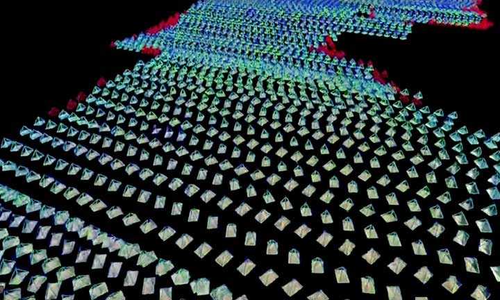
    In the presentation, Bertini will examine how drones equipped with Velodyne’s lightweight, powerful lidar can produce high-density point clouds for a forest canopy as well as the terrain underneath.

    He will also explain how this can be done at ground level with a backpack application.

    Additionally, the session will include mobile mapping case studies involving a power line inspection and surveying a solar power field.

    Attendees to AUVSI Xponential 2019 can visit the Velodyne booth to learn about Velodyne’s state-of-the-art lidar technology that delivers a high-resolution surround-view image to accurately measure and analyze the environment.

    The performance, range and compact form factor of Velodyne sensors enable developers to design versatile systems that can be configured to any mapping need.

  • Harris and Grand Sky partner on UAS BVLOS super corridor

    Harris and Grand Sky partner on UAS BVLOS super corridor

    Photo: IStock.com/valio 84sl, via FAA
    Photo: iStock.com/valio 84sl, via FAA

    Grand Sky Business and Aviation Park and Harris Corp. have joined forces to enable the country’s first and largest unmanned aerial system (UAS) airspace to support beyond visual line of sight (BVLOS) flight operations and UAS Traffic Management (UTM) research.

    Stretching up to 100 miles, this BVLOS “super corridor” is the most technologically sophisticated UAS airspace supported by multiple and redundant systems for cooperative and non-cooperative surveillance.

    These surveillance capabilities make possible a wide range of UAS BVLOS applications in precision farming, oil and gas, infrastructure inspection, public safety, package deliveries, and others.

    “Customers of Grand Sky will have access to a truly unique UAS operational capability, in addition to better facilities, comprehensive airspace surveillance, and wide operational areas,” Grand Sky Development Co. President Thomas Swoyer Jr., said. “We all benefit from efficient and safe BVLOS flight operations and a larger corridor with proven FAA collaboration and flight authorizations.”

    The surveillance system combines data feeds from a network of advanced sensors and towers. Two long-range primary radars located at Grand Forks Air Force Base and at Hillsboro, North Dakota, provide detection of non-cooperative aircraft.

    The Federal Aviation Administration (FAA) secondary radars and ADS-B network in the region, as well as local Harris ADS-B Xtend sensors, add additional layers of visibility for cooperative aircrafts in the airspace.

    Aviation-grade displays help pilots and electronic observers monitor the airspace environment over the BVLOS corridor and safely steer UAS from approaching manned aircraft.

    The combination of best practices in aviation safety management, proven technologies and experience with BVLOS regulatory approvals will make it easy for users of the airspace to advance UAS technology commercialization and routine, efficient flight operations.

    UAS operators can work with Grand Sky and Harris to develop, test, and refine a variety of complex BVLOS concepts of operations and secure waivers from the FAA for large-scale use.

    A full range of UAS operations can be supported for all types and sizes of unmanned aerial vehicles along the BVLOS corridor including a variety of airspace classes and execution of diverse defense, civil and commercial applications.

    “This is another first for Grand Sky and North Dakota in leading the UAS Industry,” Harris Vice President and General Manager of Commercial UAS Solutions George Kirov said. “The size and complexity of the airspace opened to UAS BVLOS operations is unmatched in the UAS industry. The sophistication of the Harris BVLOS system at Grand Sky is also unprecedented — linking Harris’ most advanced suite of surveillance and detect-and-avoid services with a variety of surveillance assets that, together, ensure the highest level of UAS aviation safety.”

    This partnership lays the foundation for larger and more capable surveillance corridors to enable UAS “highways” across the state of North Dakota and in support of expanding the variety of commercial UAS operations across the United States.

  • Drone aids archaeology in Scotland

    The National Trust for Scotland commissioned Glasgow-based GeoGeo to carry out a drone survey of the inner Hebridean islands of Canna and Sanday in November 2018. Using an ultra-high-definition camera, the GeoGeo team not only pinned down the exact locations of archaeological features, but also revealed new archaeological sites.

    Over five days,the drone navigated 400 kilometers to capture 4,000 images at a 3-centimeter resolution. After processing, the images created a minutely detailed 3D map capable of being used in a 3D printer to create scale models of the islands. With more than 420 million data points, it is currently the world’s largest complete island dataset captured by drone, claims GeoGeo founder Paul Georgie.

    Screenshot: GeoCue
    Screenshot: GeoCue

    “We were blown away by the results and the possibilities of this technology,” said Derek Alexander, head of Archaeology at the Trust. “We’ve previously recorded archaeology on Canna and Sanday which proves that there were inhabitants as far back as the Neolithic, but this survey gives us information and detail we just haven’t had until now. We’ve been able to obtain exact plots of known sites, but also recorded the extensive traces of cultivation, such as rig and furrow field systems that range in age from the Bronze Age onwards.”

    Screenshot: GeoCue
    Screenshot: GeoCue

    The cameras and software also will be able to help with seabird counts and habitat and coastal erosion monitoring, which are currently expensive and labor intensive, Alexander said. The trust will use the maps to update archaeological records and prepare for future groundwork and excavations.

  • Research Roundup: Design and evaluation of integrity algorithms for PPP in kinematic applications

    By Kazuma Gunning, Juan Blanch and Todd Walter, Stanford University, and Lance de Groot and Laura Norman, Hexagon Positioning Intelligence

    UAV and autonomous platforms can greatly benefit from an assured position solution with high integrity error bounds. The expected high degree of connectivity in these vehicles will allow users to receive real-time precise clock and ephemeris corrections, which enable the use of precise point positioning (PPP) techniques.

    Until now, these techniques have mostly been used to provide high accuracy, rather than focusing on high-integrity applications. The authors apply the methodology and algorithms used in aviation to determine position error bounds with high integrity (or protection levels) for a PPP position solution.

    PPP techniques can provide centimeter accuracy without local reference stations in kinematic applications. These techniques have so far mostly been used to provide high accuracy, and it is only recently that they have been proposed to provide integrity, that is, position error bounds with a very low probability of exceeding them.

    There has been preliminary work on the application of integrity to PPP, but it remains a challenge to translate the benefits of PPP to accuracy while maintaining high integrity. Most of the integrity work in PPP and real-time kinematic (RTK) has dealt more with the ambiguity resolution process under nominal error conditions and less on the integrity of the position solution under fault conditions.

    The authors overview their PPP filter implementation, and describe the threat model as well as two classes of integrity algorithms: solution separation and sum of squared residuals based (also called residual-based [RB], a misnomer, as all autonomous integrity monitors are based on the residuals.)

    They present data sets used to evaluate the algorithms, compare the protection levels (PLs) obtained with different algorithms, and present the results obtained with the most promising PL formulation in four different data sets: static, dynamic in open-sky conditions, dynamic in midtown suburban conditions, and in flight.

    Concluding, they state: “We have formulated RAIM protection-level formulas using either solution separation or the sum of residual squares. Both formulations consist of straightforward adaptations of snapshot RAIM to a Kalman filter solution.

    “For solution separation, we have shown an implementation where the computational cost of running a bank of filters is far from being proportional to the cost of one filter. Instead, we could run 50 additional filters for the cost of one.

    “For residual based RAIM we have developed a set of formulas to update the sum of square residuals from one time step to the next one. Because this test statistic is exactly the same as the one used in snapshot RAIM (when we consider the problem as a batch least squares), we could use the formula that ties the slope of a fault mode to the standard deviation of the solution separation. The slope can therefore also be updated recursively.”

    Finally, “we have refined the PPP filter, added one scenario (suburban driving conditions), and examined the effect of considering multiple faults in the formulation of the test statistics and the protection levels. The results are very promising: protection levels below 2 m appear to be achievable, and the computation load is lower than expected.”

    This paper was presented at ION-GNSS+ 2018. See www.ion.org/publications/ browse.cfm.

  • Highway gantries identify jammers

    Highway gantries identify jammers

    Recent years have seen an increase in drivers turning to cheap GNSS jamming devices in order to move around undetected or to thwart built-in anti-theft systems or road tolling systems. These jammers not only knock out their own GNSS receiver, they also block GNSS signal reception in a radius of several hundred of meters.There is a growing demand for automatic detection of these illegal jammers to help catching the offending driver.

    Septentrio GNSS antenna placement on highway gantry. (Photo: Septentrio)
    Septentrio GNSS antenna placement on highway gantry. (Photo: Septentrio)

    An ION GNSS+ 2018 presentation by Wim de Wilde and Jean-Marie Sleewaegen presentation showed how a multi-antenna GNSS receiver with built-in RF spectrum monitor and adequate processing tool can efficiently detect and classify jamming events and identify the offending car or truck. They conducted a five-day test with two Septentrio AsteRx-U dual-antenna receivers installed on an overhead structure above a busy highway.

    In parallel to the GNSS tracking and built-in anti-jam functionality, the AsteRx-U can simultaneously sample the RF signal from its two antennas. One of the objectives of the test was to evaluate the possibility to perform lane detection by cross-correlating the jamming signal received by the two antennas. In addition, the antennas were mounted with a significant inclination angle to create an asymmetrical reception pattern.

    The goal was to assess the feasibility of detecting the driving direction from the time series of the received jammer power. Such lane or direction detection would greatly help identifying the offending driver in heavy traffic conditions when more than one vehicle crosses the overhead structure at the time of the jamming.

    Over the five days of the experiment, 45 jamming events were recorded and analyzed, most of them intentional: continuous wave, chirp or even less-known pulse jammers.

    Chirp jammer example. (Charts: Septentrio)
    Chirp jammer example. (Charts: Septentrio)

    The researchers explained how the jamming events are automatically detected and classified by the processing tool, using pattern recognition to distinguish between intentional harmful events and unintentional interferences. They presented selected cases illustrating the RF signature of the most prevailing types of jammer.

    They then addressed the direction and lane sensing algorithm and discussed the effect of multipath propagation of the jammer signal. All algorithms are illustrated with real-life examples.

    For further information on this case study, see www.ion.org/publications/browse.cfm.

  • China launches new GEO BeiDou satellite

    China launches new GEO BeiDou satellite

    China launched another BeiDou satellite into space from the Xichang Satellite Launch Center in Sichuan Province at 10:41 p.m. April 20, according to Xinhua.

    The inclined geosynchronous Earth orbit (IGEO) satellite was launched on a Long March-3B carrier rocket. It is the 44th satellite of the BDS satellite family and the first BDS-3 satellite in inclined geosynchronous Earth orbit.

    After in-orbit tests, the satellite will work with 18 other BDS-3 satellites in intermediate circular orbit and another IGEO satellite.

    Yang Changfeng, chief designer of the BeiDou system, told Xinhua that the hybrid constellation design will increase the number of visible satellites in the Asia-Pacific region.

    According to Yang, the positioning accuracy of the system has reached 10 meters globally and five meters in the Asia-Pacific Region after the system started to provide global service at the end of last year.

    The BDS has been widely used around the world, such as in building construction in Kuwait, precision agriculture in Myanmar, land survey and mapping in Uganda and warehousing and logistics in Thailand.

    About 8-10 BDS satellites are scheduled to be launched this year, wrapping up launch missions of all BDS-3 satellites in medium Earth orbit. The BDS-3 system is to be completed in 2020.

    China is also planning to finish building a high-precision national comprehensive positioning, navigation and timing (PNT) system based on BeiDou by 2035.


    Featured photo: Xinhuanet

  • UAvionix partners with CubePilot on ADS-B IN for carrier board

    UAvionix partners with CubePilot on ADS-B IN for carrier board

    Photo: uAvionix
    Photo: uAvionix

    uAvionix has announced a partnership with autopilot maker CubePilot to integrate ADS-B IN receive capability into its carrier board.

    uAvionix is the designer and manufacturer of communications, navigation and surveillance (CNS) equipment for unmanned and manned aircraft.

    CubePilot is the designer and manufacturer of the “The Cube” autopilot (formerly known as Pixhawk) for unmanned aircraft systems (UAS).

    The new carrier board, available in July, integrates uAvionix’s custom ADS-B silicon for 1090-MHz ADS-B reception for worldwide detect and avoid (DAA) functionality.

    With this integration, UAS operators will be able to see nearby ADS-B OUT enabled aircraft on ARDUPILOT’s Mission Planner, providing the remote pilot in command (RPIC) with timely notification to take the necessary actions to remain well clear.

    CubePilot, which uses the open-source ARDUPILOT platform, previously provided plug-and-play functionality for several uAvionix ADS-B IN and OUT products, including PingRX, Ping2020i and Ping1090i. Support for these products is retained in the new design, allowing for 978MHz ADS-B reception or integration of ADS-B OUT functionality.

    “With this partnership, uAvionix furthers our goal of ensuring safety and common situational awareness between airspace users,” states Christian Ramsey, uAvionix president. “We believe that ADS-B IN functionality should be a requirement for every DAA system for UAS operations over people or beyond visual line of sight, and meeting that requirement should not be cost prohibitive.”

    “The safe integration of UAS into the National airspace of any country needs to take a safety-first approach from all players,” said Philip Rowse, Hex/ProfiCNC (CubePilot) CTO. “By partnering with uAvionix and including the ADSB-in at practically no cost to the customer, we remove the cost barrier, adding safety to our customers’ UAS solutions.. We envisage this added situational awareness, and optional auto avoidance behavior will be an important step towards safely shared skies.”

    Visit uAvionix at AUVSI Xponential in Chicago April 30-May 2 at Booth 4421 and CubePilot at Booth 1816.

  • Quanta UAV INS/GNSS improves UAV-based surveying

    Quanta UAV INS/GNSS improves UAV-based surveying

    SBG Systems will present its Quanta UAV series at AUVSI’s Xponential show, which takes place April 30-May 2 in Chicago. The Quanta UAV series is a line of inertial navigation systems (INS) dedicated to UAV-based surveying integrators.

    Because SBG Systems wants UAV surveyors to save autonomy for additional survey lines, the company has designed a small, lightweight, and low-power INS offered on two levels of accuracy. Quanta UAV and Quanta UAV Extra have been developed for compact lidar to high-end BVLOS mapping solutions. They provide precise orientation and centimeter-level position data delivered both in real time and post processing. This direct geo-referencing solution eliminates the need for ground control points and greatly reduces the need of overlapping.

    Qinertia, SBG’s post-processing software completes the Quanta UAV offer. It gives access to offline real-time kinematic (RTK) corrections from more than 7,000 base stations in 164 countries, the company said. Trajectory and orientation are greatly improved by processing inertial data and raw GNSS observables in forward and backward directions. This advanced software also computes the base station position to quickly provide centimeter accuracy. Qinertia comes free for one year with the Quanta UAV sensor.

    Robotics and surveying. Quanta UAV is the result of SBG’s expertise in both miniaturized technology for drone navigation and high-end sensors for mobile mapping. Designed as a geo-referencing solution, it can also be used as a high-end navigation solution to feed the UAV autopilot.

    Quanta UAV benefits from a tight integration with in-house IMUs, advanced calibration techniques and algorithms that ensure consistent behavior in all weather conditions, as well as robust position even if the UAV gets close to buildings, electrical lines or trees.

    Quanta UAV embeds a web interface for an easy configuration with a 3D view showing all parameters. The calibration tool automatically aligns the lever arm between the two antennas and the sensor, and re-estimates it in flight for more precision.

    The ITAR-free Quanta UAV INS are available for order.


    Featured photo: SBG Systems

  • UAvionix offers testing of CNPC command link radios for UAS

    UAvionix offers testing of CNPC command link radios for UAS

    uAvionix, designer and manufacturer of communications, navigation, and surveillance (CNS) equipment for unmanned and manned aircraft, is testing its prototype of a command and non-payload control (CNPC) radio for unmanned aircraft systems (UAS) and urban air mobility vehicles.

    Photo: Allison Barwacz
    Photo: Allison Barwacz

    SkyLink is an L-band frequency-modulated CNPC radio ultimately intended for point-to-point or networked Beyond Visual Line of Sight (BVLOS) UAS operations. uAvionix has focused on minimizing size, weight, and power consumption (SWaP) while maximizing range and spectrum efficiency.

    The current 50-gram 10-Watt prototype is testing successfully at ranges exceeding 40 miles at low altitude. uAvionix is testing under an experimental transmit license and approval from the Federal Communications Commission and Federal Aviation Administration, respectively.

    Prior to founding uAvionix, CEO Paul Beard invented and brought to market the Spektrum digital spread spectrum radio control (RC) technology which moved the control link from 27 and 72 MHz bands to a high-bandwidth 2.4-GHz ISM band.

    “Building high performance datalinks for airborne applications is insanely challenging,” said Beard. “Combining our ability to produce TSO certified equipment with the experience of developing and deploying millions of commercial products globally with Spektrum, we expect to bring affordable, scalable, and safe solutions to enable the UAS and UAM markets.”

    Visit uAvionix at AUVSI Xponential 2019 at booth 4421.

  • 3D mapping of Notre Dame will help restoration

    3D mapping of Notre Dame will help restoration

    Detailed 3D maps of the iconic and historic Notre Dame Cathedral in Paris hold out hope for accurate reconstruction after it was devastated by a massive fire April 15. Both the ceiling and the spire were destroyed, as well as internal woodwork.

    But the information to restore the cathedral is abundant. Besides photos, in 2015 art historian Andrew Tallon used laser scanners to create an immaculately accurate model of the cathedral, as reported in this National Geographic feature.

    Laser scans, with their exquisite precision, don’t miss a thing. Mounted on a tripod, the laser beam sweeps around the choir of a cathedral, for example, and measures the distance between the scanner and every point it hits. Each measurement is represented by a colored dot, which cumulatively create a three-dimensional image of the cathedral. “If you’ve done your job properly,” says Tallon, the scan is “accurate to within five millimeters [.5 centimeter].”…

    Tallon figured out how to knit the laser scans together to make them manageable and beautiful. Each time he makes a scan, he also takes a spherical panoramic photograph from the same spot that captures the same three-dimensional space. He maps that photograph onto the laser-generated dots of the scan; each dot becomes the color of the pixel in that location in the photograph.

    As a result, the stunningly realistic panoramic photographs are amazingly accurate. At Notre Dame, he took scans from more than 50 locations in and around the cathedral—collecting more than one billion points of data.

    Assassin’s Creed Unity. Another source comes from a video game company. Immaculate models of the cathedral were collected for the creation of the best-selling “Assassin’s Creed: Unity,” where the hero/player is able to climb both the outside and inside of the massive edifice.

    An artist for the Ubisoft game, Caroline Miousse, told The Verge:

    In the case of the Notre Dame, easily the biggest structure in the game, it meant recreating a version of the cathedral that didn’t actually exist at the time. Level artist Miousse spent literally years fussing over the details of the building. She pored over photos to get the architecture just right, and worked with texture artists to make sure that each brick was as it should be.


    Feature image: Ubisoft

  • Orolia technology synchronizes black hole photo telescopes

    Image: Event Horizon Telescope Collaboration
    Image: Event Horizon Telescope Collaboration

    Atomic clocks support world’s first black hole photo

    Orolia, through its joint venture company T4Science Inc. in Switzerland, supported the ground-breaking scientific initiative to capture the world’s first photo of a black hole, conducted by the Event Horizon Telescope (EHT) project.

    As a leader in maser atomic clock technology, Orolia provided the critical timing solution to synchronize telescopes around the world and create a virtual telescope the size of Earth to observe this deep space, supermassive object.

    Some of the world’s most advanced telescopes, located at challenging high-altitude sites, were synchronized with T4Science Masers to capture the sharpest image possible. Locations included volcanoes in Hawaii, Arizona mountains, the Spanish Sierra Nevada, the Chilean Atacama Desert and Antarctica.

    T4Science masers deliver ultra-precise time synchronization in the most challenging environments on Earth and in Space.

    The EHT project uses very long baseline interferometry (VLBI). This technology requires synchronization, phase stability and phase coherence between different telescopes within a few femto-seconds, and leverages the Earth’s rotation to form one Earth-size telescope.

    VLBI enables the EHT to achieve an angular resolution of 20 micro-arcseconds — enough to read a newspaper in New York from a sidewalk café in Paris.

    Orolia delivers this critical VLBI technology through its T4Science iMaser-3000 hydrogen masers. The iMaser-3000 is a VLBI atomic clock, supporting other mission-critical timing programs such as military and commercial satellite applications.

    “Orolia has been a proud supporter of space research and missions for more than forty years,” said Orolia CEO Jean-Yves Courtois. “As the world leader in resilient positioning, navigation and timing solutions, we develop precise, ultra-reliable technology for environments where failure is not an option.”

    Orolia’s proven timing solutions support many space agencies and research institutes worldwide, including ESA, NASA, Jet Propulsion Laboratory, SpaceX, the Centre National d’Étude Spatiales (CNES France), the National Physics Laboratory (UK), Deutsches Zentrum für Luft-und Raumfahrt (DLR Germany) and the Japan Aerospace Exploration Agency (JAXA), among others.

  • Fallout from GPS rollover includes NOAA, Samsung, NYC, Boeing

    Fallout from GPS rollover includes NOAA, Samsung, NYC, Boeing

    The GPS Week Number Rollover, which took place April 6, has caused several automated NOAA stations to go offline.

    Some of the outages could last until November.

    Photo: NOAA
    Photo: NOAA

    According to the EOS website, 19 National Oceanic and Atmospheric Administration (NOAA) coastal and marine automated stations were not updated to mitigate the issue, and those stations are out of commission until workers can service them on location.

    In Alaska, five of the stations in and around Cook Inlet are down.

    The New York Times is reporting that at 7:59 p.m. EDT on Saturday, the New York City Wireless Network went dark, interrupting functions such as the collection and transmission of information from some Police Department license plate readers, Department of Transportation traffic-light programming, and communications at remote work sites for the sanitation and parks departments.

    The city is now working overtime to bring affected systems back online, reports StateScoop.

    Some users of Samsung smartphones and tablets are also reporting issues.

    Previously, GPS World reported on rollover issue for the Australian Bureau of Meteorology’s (BOM) weather balloons, as well as Boeing aircraft. Read more about the Boeing issue here.