Author: Tracy Cozzens

  • Record-breaking satellite advances NASA’s exploration of high-altitude GPS

    Record-breaking satellite advances NASA’s exploration of high-altitude GPS

    GPS signals extend farther than expected, meaning future space missions can reliably use GPS at extreme altitudes.

    By Danny Baird
    ​NASA’s Goddard Space Flight Center, Greenbelt, Maryland

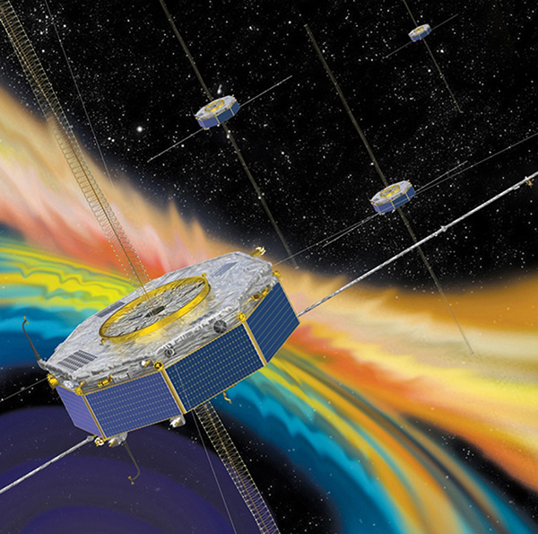
    The four Magnetospheric Multiscale (MMS) spacecraft recently broke the world record for navigating with GPS signals farther from Earth than ever before. MMS’ success indicates that NASA spacecraft may soon be able to navigate via GPS as far away as the Moon, which will prove important to the Gateway, a planned space station in lunar orbit.

    After navigation maneuvers conducted this February, MMS now reaches over 116,300 miles from Earth at the highest point of its orbit, or about halfway to the Moon. At this altitude, MMS continued to receive strong enough GPS signals to determine its position, shattering previous records it set first in October 2016 and again in February 2017.

    This demonstrates that GPS signals extend farther than expected and that future missions can reliably use GPS at extreme altitudes.

    “At the first apogee after the maneuvers, MMS1 had 12 GPS fixes, each requiring signals from four GPS satellites,” said Trevor Williams, the MMS flight dynamics lead at NASA’s Goddard Space Flight Center in Greenbelt, Maryland. “When we began the mission, we had no idea high-altitude GPS would be such a robust capability.”

    MMS’ orbit shift allows it to continue its mission to better understand the complex magnetic processes around Earth. MMS studies a fundamental process that occurs throughout the universe, called magnetic reconnection, in which magnetic fields collide and explosively release particles in all directions. Near Earth, reconnection is a key driver of space weather, the dynamic system of energy, particles and magnetic fields around Earth which can adversely impact communications networks, electrical grids and GPS navigation. Magnetic reconnection was long predicted by physicists, but not directly observed until the MMS mission.

    To study Earth’s magnetosphere, the region of space dominated by the planet’s magnetic field, MMS spacecraft maintain a highly elliptical orbit around Earth. A highly elliptical orbit resembles a long oval around the globe with an extreme high point, or apogee, and low point, or perigee.

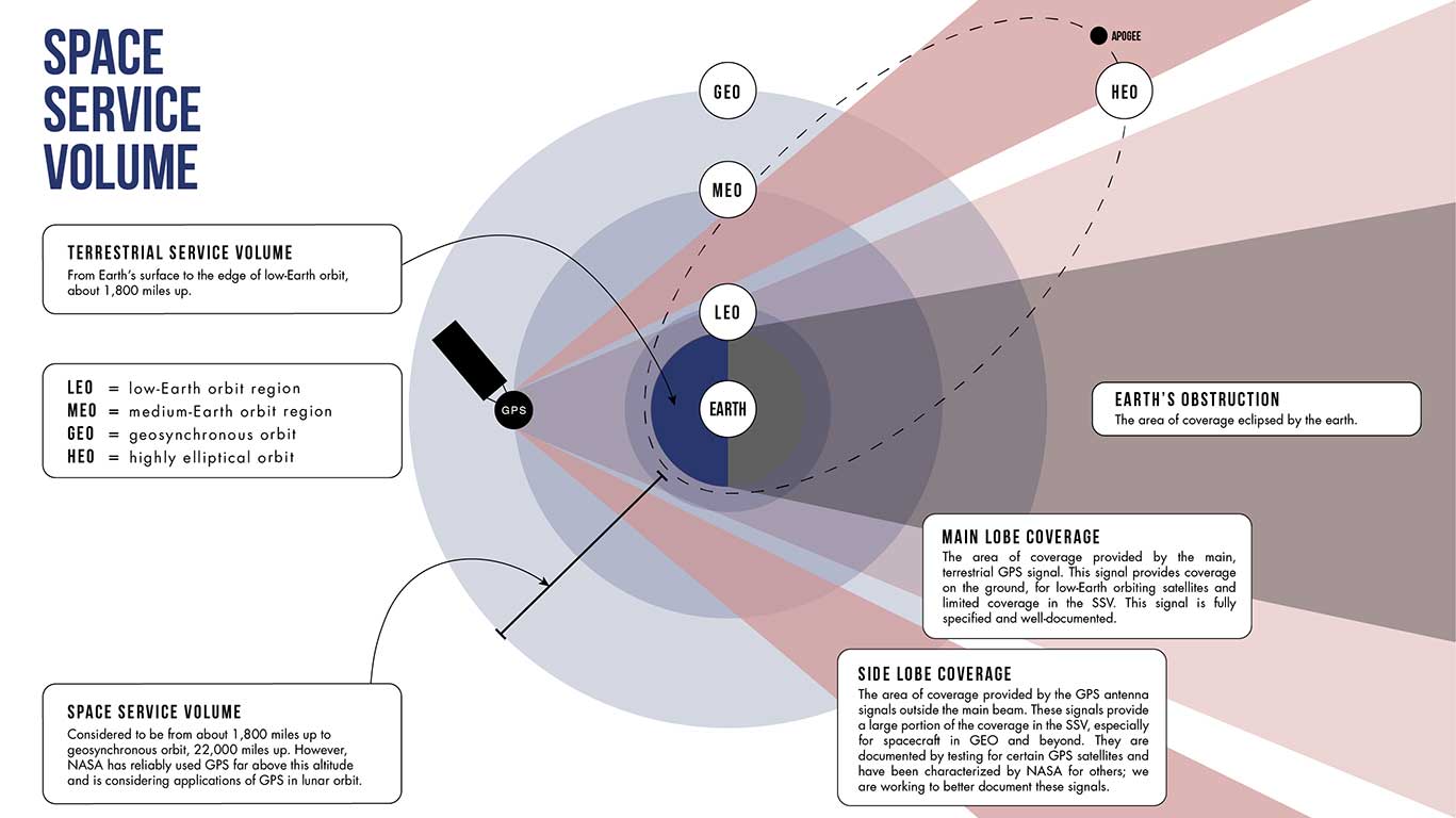
    MMS’ tight formation and highly elliptical orbit require extremely accurate navigation data from GPS satellites, which are operated by the U.S. Air Force. The main GPS antenna signals enable navigation down on Earth, but precise high-altitude navigation requires both these as well as signals from the antenna’s side lobes. Side lobe signals radiate out to the side of the direction an antenna is pointing and extend past Earth.

    A simplified antenna radiation pattern with different lobes of radiation extending from the antenna. (Image: NASA)
    A simplified antenna radiation pattern with different lobes of radiation extending from the antenna. (Image: NASA)

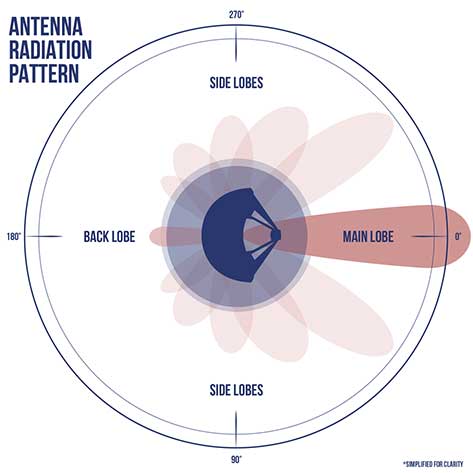
    Communications engineers usually consider these side lobes wasted energy. However, the signals can be used by satellites at high altitudes on the opposite side of the globe as the GPS satellite. (Such high-altitude missions fly above GPS satellites’ orbit.) Previously, most engineers considered the upper limits of the GPS navigation in space to be an altitude of about 22,000 miles, or the altitude of satellites in geosynchronous orbit — until MMS.

    Additionally, the navigation maneuvers allowed the spacecraft to gather data not available to scientists during normal operations.

    “MMS usually flies in a close, tetrahedral formation [that looks like a pyramid],” said Thomas Moore, the project scientist for MMS at Goddard. “During the orbit-raising maneuvers, the spacecraft became a [straight line or] ‘string of pearls,’ which gave us unique data about the magnetosphere that may further our understanding of magnetic reconnection.”

    MMS’ tight configuration and record-breaking GPS fixes would not be possible without the mission’s Navigator GPS receiver, an instrument developed at Goddard. It can detect faint GPS signals while withstanding the harsh radiation environment within the magnetosphere. NASA has made this revolutionary technology available for licensing through the Technology Transfer program, ensuring that commercial enterprise can also benefit from this innovation.

    A diagram showing how GPS antenna signals can serve spacecraft at high altitudes. (Image: NASA)
    A diagram showing how GPS antenna signals can serve spacecraft at high altitudes.
    (Image: NASA)

    In fact, NASA simulations show GNSS signals could even be used for reliable navigation in lunar orbit, just as a car uses GPS on an interstate highway. Engineers are considering using GNSS signals in the navigation architecture for the Gateway, an outpost in orbit around the Moon that will enable sustained lunar surface exploration.

    “We’re working with the international community to document GNSS performance for space users, including side lobe signals,” said Joel Parker, a Goddard navigation engineer representing NASA internationally in GNSS policy. “A better understanding of GNSS capabilities will allow high-altitude missions to take advantage of the robust navigation signals they provide.”

    Illustration of the four MMS spacecraft in orbit in Earth's magnetic field. (Image: NASA).
    Illustration of the four MMS spacecraft in orbit in Earth’s magnetic field. (Image: NASA).

    Thanks to MMS and NASA’s navigation engineers, the sky is no longer the limit.

    NASA’s Science Mission Directorate provides strategic oversight to MMS. Goddard’s Explorers and Heliophysics Projects Division manages the mission. The four MMS spacecraft launched on March 13, 2015, from NASA’s Kennedy Space Center in Cape Canaveral, Florida, on board an Atlas V launch vehicle.

    NASA’s Space Communications and Navigation (SCaN) program office oversees the agency’s work in navigation policy related to GNSS. NASA, consulting the United Nations International Committee on GNSS (ICG), collaborates with other U.S. agencies and the six international GNSS providers to define GNSS requirements and develop additional capabilities. The team of SCaN navigation specialists charged with aiding the ICG are based out of the Exploration and Space Communications projects division at Goddard.


  • Trimble Siteworks Software adds GNSS tilt compensation, Android support

    Trimble Siteworks Software adds GNSS tilt compensation, Android support

    Screenshot: Trimble
    Screenshot: Trimble

    Trimble has introduced Siteworks Software version 1.1, featuring full GNSS tilt compensation functionality in standing, walking and vehicle modes, and support for the Android operating system.

    Construction surveyors can now capture accurate points without leveling the pole, making surveying in areas such as building corners accurate, fast and easy.

    In addition, Siteworks version 1.1 now supports the Android operating system, giving contractors the flexibility to choose the field device that best fits their needs and budget.

    The announcement was made at the bauma 2019 trade fair for construction machinery, building material machines, mining machines, construction vehicles and construction equipment. Bauma 2019 takes place this week in Munich.

    “GNSS tilt compensation makes site positioning more accessible and easier to learn for beginners, while experienced surveyors can see significant time savings,” said Scott Crozier, general manager for Trimble’s Civil Engineering and Construction Division. “And now Trimble Siteworks gives contractors more choices. They can run Siteworks on either Windows 10 or Android.”

    GNSS Tilt Compensation

    Using Trimble Siteworks and a Trimble SPS986 GNSS smart antenna, construction surveyors can take measurements faster and perform more efficient stakeouts.

    The solution was designed to shield magnetic interference, and it can be used effectively anywhere on a construction site.

    There are three modes available that support tilt compensation, so contractors can record accurate points while standing, walking or driving the site in a vehicle. Tilt compensation in vehicle mode is designed to capture higher accuracy measurements on steeper slopes from a moving vehicle, and more accurate volume measurements to save time and money on material planning.

    Easy to use for beginners and users without traditional training, tilt compensation allows points to be recorded more safely, eliminating the need to stand in the road to measure a traffic lane, for example. Surveyors can also measure points that they couldn’t before, such as building corners, edges of trenches and utility flowlines.

    Trimble Siteworks for Android

    Trimble Siteworks can now support a contractor’s bring-your-own-device (BYOD) strategy with Android compatibility. This is helpful for price-conscious users such as owner operators and utility contractors, or users who need a less rugged solution for lighter use.

    The option gives contractors the freedom to choose the device that works best for them, increasing the flexibility and affordability of the Trimble Siteworks Positioning System.

    Availability

    Trimble Siteworks Software version 1.1 is expected to be available through the worldwide SITECH distribution channel in the second quarter of 2019.

  • Hemisphere GNSS introduces GradeMetrix machine control platform

    Hemisphere GNSS introduces GradeMetrix machine control platform

    Photo: u-box
    Hemisphere GNSS’ IronOne tablet running GradeMetrix software.

    Hemisphere GNSS introduced its GradeMetrix platform, a machine guidance solution for high-precision GNSS-based machine control and guidance applications and systems, at bauma 2019.

    GradeMetrix positioning systems — as well as the new Earthworks OEM solution toolkit — will be featured in the Hemisphere stand (A2.228) at bauma 2019 in Munich, Germany, April 8-14. Bauma 2019 is a construction machinery trade show.

    GradeMetrix

    Hemisphere’s GradeMetrix portfolio includes solution offerings for dozer and excavator earth-moving applications. Hemisphere continues to make significant strides forward with its next-generation GradeMetrix solutions through its network of machine control dealers and value-added resellers (VAR). Whether it is grading, mining, excavating, or compaction applications, GradeMetrix solutions provide superior performance at an exceptional value.

    “GradeMetrix and Earthworks OEM platforms and design services empower dealers, VARs, and original equipment manufacturer (OEM) customers with unparalleled flexibility and price points for designing, complementing, and delivering their own scalable solutions,” said Randy Noland, vice president of global sales and business development at Hemisphere. “These offerings deliver a new generation of positioning systems by removing multiple barriers to entry and higher adoption rates, especially to smaller customers, machines, and markets.”

    Earthworks OEM toolkit

    Hemisphere also announced its Earthworks OEM toolkit ,which allows manufacturers to select components as à la carte or complete solutions, based on their accuracy and durability requirements to integrate into their machines and design their own IP, enabling them to maintain a competitive advantage in the marketplace.

    The customizable and flexible toolkit provides the ability to tailor displays and outputs, per their requirements, providing OEMs with flexible options to build their own branded systems. This allows for much faster times to market, driving increased revenue streams for OEMs, and provides a high cost/value ratio. From grading, to mining, to excavation, Hemisphere’s Earthworks OEM toolkit increases accuracy, efficiency and profitability.

    Speeding time to market and customer

    In the increasingly competitive OEM marketplace, manufacturers are scrambling to get positioning and other non-native technologies out to market on their machines. As the uptake of this technology becomes more mainstream with the customer base, each OEM, VAR and even super distributor are all racing to define a profitable system design they can deploy through their own channels.

    With the release of GradeMetrix and Earthworks OEM product lines, Hemisphere is addressing this demand. Typical development times for OEMs with vendors for positioning systems is measured in years, not months. With these new product lines, Hemisphere is providing a new avenue for these customers to get their own system established and into the marketplace, much faster and with lower development costs.

  • KVH showcases IMUs at Ocean Business 2019

    KVH showcases IMUs at Ocean Business 2019

    Image: KVH
    The GEO-FOG 3D Dual inertial navigation system (INS) is designed for applications that require heading at system startup or in low dynamic conditions. (Image: KVH)

    KVH Industries will showcase its inertial products at Ocean Business 2019, taking place in Southampton, U.K., April 9-11.

    When GNSS is not an option, KVH’s Fiber Optic Gyro (FOG)-based IMUs and inertial navigation systems — the GEO-FOG 3D and 3D Dual — provide accurate and reliable navigation for manned and unmanned maritime and underwater systems, the company said.

    “When we compare the data and performance of the KVH 1750 IMU to comparable SWAPC components, we find a tremendous disparity in performance,” said Ben Kinnaman, CEO of Greensea Systems Inc. “The KVH 1750 IMU outperforms similar components and sensors in that category by orders of magnitude.”

    Visit KVH at Stand J8 and learn more about KVH’s FOG-based 1750 IMU, which is available with 2g accelerometers and designed specifically for subsea vehicle navigation and positioning.


  • Geneq offers redesigned, efficient battery for SXblue receivers

    Geneq offers redesigned, efficient battery for SXblue receivers

    Photo: Geneq
    Photo: Geneq

    Geneq inc. has released a redesigned, ultra-efficient battery for its SXblue receivers.

    The new battery is equipped with 4 Li-ion rechargeable cells that boost its capacity from 3900 mAh to 6000 mAh. The upgrade boosts the receiver’s autonomy by up to 50 percent, greatly increasing its field work efficiency, the company said.

    When fully charged, the battery can last up to 16 hours depending on the SXblue model and Bluetooth connectivity.

    Photo: Geneq
    Photo: Geneq

    The colored LEDs for the battery charge indicator have been enhanced for a better contrast even when working under sunny conditions. Like previous versions, the new battery is field replaceable and can be charged separately or while it is connected to the receiver. With only a 6-mm increase in thickness and the same weight as previous models, the user will not notice any change in handiness and ergonomics, Geneq added.

    The new battery is compatible with all past SXblue II and III models and current iSXblue II+ GPS, SXblue II+ GPS, iSXblue II+ GNSS, SXblue II+ GNSS and SXblue Platinum. It is also compatible with the new pole clamp accessory for the survey kit.

  • Did the chicken you’re eating live a happy life?

    Did the chicken you’re eating live a happy life?

    Portlandia Prediction: Fred Armisen and Carrie Brownstein have a few questions about their chicken dinner. (Screenshot: IFC)
    Portlandia Prediction: Fred Armisen and Carrie Brownstein have a few questions about their chicken dinner. (Screenshot: IFC)

    In 2011, the first-ever episode of a TV comedy called “Portlandia” debuted. In one sketch, concerned diners played by series stars Fred Armisen and Carrie Brownstein question their waitress about the origins of their chicken dinner.

    The waitress shows the couple the chicken’s papers and photo — Colin the Chicken lived a free-range life on a four-acre woodland farm only 30 miles away, dining on sheep’s milk, soy and hazelnuts, in the company of his chicken friends. Unconvinced even by these details, the couple decides to drive to the farm to see it for themselves.

    Enter GoGo Chicken

    In a case of comedy becoming reality, Chinese insurance company ZhongAn Online has outfitted more than a 100,000 chickens with GPS trackers. People who buy a chicken with a tracker strapped to its leg will know every step that that chicken has taken. Using a smartphone app called GoGo Chicken, customers can monitor the animal’s diet, exercise and environment.

    The company says its technology will be on 2,500 farms in China by next year. It is also working on facial-recognition technology so that consumers can make sure the organic chicken they saw on the farm is the same one that ends up on their plate.

    While this all sounds a bit much for many of us who grew up on Chicken McNuggets, there is a practical side. The company hopes GPS tracking will help prevent food safety problems, such as a 2014 crisis in China in which a supplier was caught selling rotting and expired meats to fast-food chains. In the event an issue does arise, the data tracked by the devices could help find the source of the problem.

  • Cooperative utility effort takes off with Topcon

    Cooperative utility effort takes off with Topcon

    Images: Topcon
    Images: Topcon

    An Arizona electric cooperative that serves more than 33,000 customers is helping prove the value and potential of unmanned aerial systems (UAS) in enhancing the utility’s geospatial information system (GIS) effort.

    Using an Intel Falcon 8+ Drone — Topcon Edition, UAS specialist Skynetwest is performing missions to illustrate the viability of UAS technology. Initial work for the Navopache Electric Cooperative (NEC) included inspection of a substation, conducted on a windy day that might have grounded traditional aircraft.

    Windspeed limits for the Falcon 8+ in GPS mode are set at 26 mph; in height mode that threshold is extended to windspeeds as high as 35 mph.

    Using ContextCapture and Agisoft PhotoScan software, Skynetwest created a detailed georeferenced 3D model of the substation.

    The Falcon 8+ also has triple-redundancy inertial measurement units (IMUs), double redundant compasses, dual-constellation GPS, eight propellers and two batteries. An algorithm selects the most accurate of the redundant systems to use when the UAS is flying near the electromagnetic frequencies emitted by power lines.

    The team easily switched between a camera payload for inspections and one for mapping. Skynetwest’s mapping package takes high-resolution geo-referenced aerial images from various heights within set GPS tolerances. Its RGB camera delivers both orthophotos and 3D models in Topcon ContextCapture software, powered by Bentley Systems.

  • Peering behind the mapping curtain

    Peering behind the mapping curtain

    Photo: Mapbox
    Photo: Mapbox

    Location intelligence powers applications with data and “live maps” updated continuously.

    According to Forbes, 70 percent of telecommunications companies consider location intelligence critical to their success. The intelligence data is provided by specialists such as Google, Esri, Here and PlaceIQ.

    In January, Sprint and location intelligence startup Mapbox launched precision mapping technology with the Curiosity IoT network. The 5G network’s extreme bandwidth and low latency will allow Mapbox to collect higher volumes of richer data to create “live maps.” A live map is built not from traditional data surveys months or years before, but from data collected from hundreds of millions of location-enabled sensors that feed back information about the world in real time, including high-resolution video.

    Mapbox uses artificial intelligence (AI) to turn the massive data flows into a picture of real time transit paths that can be used for precise, up-to-date routing.

    Augmented Reality view from the Mapbox Vision SDK. (Image: Mapbox)
    Augmented Reality view from the Mapbox Vision SDK. (Image: Mapbox)

    According to Mapbox CEO Eric Gundersen, maps that constantly update are essential to the internet of things (IoT). “As maps guide new smart machines on IoT networks, you remove the human in the middle that used to compensate for differences between the map and the real world,” he said. “Precision mapping services need to reflect the world as it is, at that precise moment so that those smart machines can travel safely and efficiently.“

    According to Mapbox, smart machines such as drones and autonomous delivery carts will be able to make fast location and routing decisions using its detailed, updated maps.

    Other companies that use Mapbox’s location services include IBM, Lonely Planet, Square, Tableau and The Weather Channel.

  • Averna’s latest development tools accelerate IoT deployment

    Averna’s latest development tools accelerate IoT deployment

    Image: Averna
    Image: Averna

    Averna has launched a series of development tools that enable the real-time monitoring of assets.

    The Averna ConnexThing Toolkits enable customers to quickly connect new and existing manufacturing test assets to PTC’s ThingWorx Industrial IoT Platform.

    Each toolkit targets a specific programming language or test sequencer to accelerate the implementation and deployment of an internet of things (IoT) solution with ThingWorx.

    The ConnexThing Toolkit for NI TestStand, which is available for download now, streamlines the connection between TestStand’s ready-to-run test management software and ThingWorx’s innovative end-to-end IoT platform. It comes complete with templates, data shapes, widgets and dashboard examples that easily link test stations.

    The ConnexThing Toolkit for NI TestStand:

    • accelerates integration of ThingWorx with TestStand
    • enables easy monitoring of test stations and asset management using the configurable ThingWorx dashboard tool
    • orchestrates bi-directional communication
    • provides guidance for clean code and architecture.

    “The Averna ConnexThing Toolkit is the first in a series of new operational technology (OT) solutions designed to help clients gain insight on manufacturing and test processes and deploy Smart Connected Operations,” said Jean-Levy Beaudoin, VP Platforms & Innovation for Averna. “By leveraging the power of PTC’s ThingWorx Industrial IoT Platform together with our test assembly automation and machine vision expertise, Averna is uniquely qualified to help organizations achieve their digital transformation, enabling further productivity and quality improvement.”

    “PTC is pleased to have Averna in the PTC Partner Network, allowing for their recognized quality and test expertise to be made readily available to ThingWorx customers,” said JP Provencher, vice president of manufacturing strategy and solutions at PTC. “The ThingWorx extensions they have built help manufacturing companies improve test and quality processes by making them connected, real-time, predictive, and augmented.”

    The Averna ConnexThing for NI TestStand is available to download now as a free 90-day trial, directly from the PTC Marketplace or Averna website.

  • 4G LTE-M personal tracker offered by WTS Positioning

    4G LTE-M personal tracker offered by WTS Positioning

    Photo: WTS Positioning Solutions
    Photo: WTS Positioning Solutions

    WTS Positioning Solutions, a Swedish GPS tracking company, has released its next generation of smart GPS trackers: the Trax G+ series.

    At the top of the range is Trax G+ 4G LTE-M, one of the first LTE trackers commercially available on the market, the company said. It supports 4G LTE-M and NB-IoT standards, with both European and U.S. models available.

    WTS has also released two new, improved GPS models using 3G and 2G standards, to complete the new Trax G+ range.

    Trax G+ tracker.  Trax G+ is a small GPS tracker for personal use. It has real-time tracking capability with update rates of up to every 10 seconds. For customised industrial applications, the new Trax G+ can support up to two updates per second. It also comes with wireless charging and IP68 water resistance.

    The Trax G+ App, available in the App Store and Google Play, has a wide range of features including Unlimited Geofences, Augmented Reality Tracking, Speed Alerts, Location History, the possibility to track multiple devices and device sharing.

    WTS works closely with brands across several consumer markets, including sports gear, event management, security, search and rescue, homecare and telecommunications.

    Photo: WTS Positioning Solutions
    Photo: WTS Positioning Solutions

    Tracking vest. A special collaboration with POC sports brand, manufacturer of helmets, body armour and sports apparel, resulted in an ISPO Gold Winner award for the POCito VPD Air Vest + TRAX POC edition.

    The vest provides a child with back protection for winter sports and is designed to store a TRAX POC Edition device. It is an integrated protection, alert and tracking system that allows parents to monitor and keep children safe on the slopes.

    POC will present the vest at ISPO Munich, held Fe.b 3-6, in Hall B6, Booth 414.

    Trax G+ data plans are offered in 6-, 12- and 24-month pre-paid packages and offer international coverage and free roaming in all supported countries.

    WTS Positioning Solutions are specialists within the GNSS industry, supplying personal GPS trackers, plus customised hardware, software, server and data solutions for high-precision real-time location and tracking information.

  • Galileo now predicts the weather

    Galileo now predicts the weather

    Image: Spire
    Image: Spire

    Spire Global, a space-to-cloud analytics company, is now using Galileo to offer GNSS radio occultation (GNSS-RO) products for the weather community. Radio occultation is the process of using satellites to measure how GNSS signals are refracted by the Earth’s atmosphere.

    Two of Spire’s nanosatellites are the first to use Galileo signals to measure GNSS-RO profiles, a service now available to Spire’s global user base as a new tier of data for advanced weather prediction. The satellites launched on Nov. 29, 2018, from Sriharikota, India.

    The satellites are part of the collaborative European Space Agency ARTES Pioneer Space-as-a-Service program, which aims to prove the value of using nanosatellites for space-based GNSS-RO.

    With Galileo, Spire’s weather observation satellites can harvest approximately 25 percent of the total GNSS-RO profiles available from the existing GNSS satellite constellations in orbit today.

    Spire operates 72 nanosatellites — also known as “cubesats” — and more than 30 ground stations throughout the world. The nanosatellites are developed, assembled and tested at Spire’s production facility in Glasgow, Scotland.

  • Yuneec provides RTK on commercial hexacopter H520

    Yuneec provides RTK on commercial hexacopter H520

    Photo: Yuneec
    Photo: Yuneec

    Yuneec International’s commercial hexacopter, the H520, will now optionally be available with an RTK (real-time kinematic) system from the Swiss company Fixposition.

    Under difficult GPS conditions, such as in cities or canyons, the RTK system ensures maximum precision and centimeter-precise positioning. The fully integrated RTK satellite navigation enables extremely accurate recurring images and faster 3D mapping. It also makes automated inspection flights easier and more precise, the company said.

    The new H520 RTK is suitable for commercial applications that require maximum precision. By using RTK technology, the H520 can now fly much closer to objects for inspection as the UAV positions itself precisely in the centimeter range (1 cm + ppm horizontal / 1.5 cm + ppm vertical) rather than in the meter range, which is standard for the H520.

    This accuracy is paramount for applications where several images need to be taken at the same location on different days including:

    • documenting progress on construction sites,
    • inspecting mountain landscapes to prevent natural hazards such as rock falls or avalanches, and
    • forensic accident scene reconstruction.

    In addition, the satellite navigation system makes it possible to significantly reduce image overlaps, which means fewer photos and shorter model calculation times, maximizing efficiency in workflows.

    The RTK system is not only fully integrated into the hardware, but also into the UAV’s software. This means the user retains the full range of functions of the DataPilot software, including mission flights.

    The H520 RTK works with two components: the RTK module on board the H520 and a base station on the ground. For precise navigation, the module supports constellations of up to three different satellite systems from GPS, GLONASS, Galileo and BeiDou.

    If the use of a ground station is not possible, the system can also be operated with a national reference station network (network RTK). The network RTK is provided by third-party providers and requires an internet connection, such as a mobile hotspot. All data including satellite data is recorded, which makes the H520 RTK suitable for post-processed kinematics (PPK).

    The H520 RTK will be available in the second quarter of 2019. Technical specifications are available here.