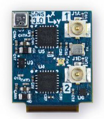
Dime-sized INS with RTK paves the way for high accuracy in mass-market consumer applications.
Photo: Inertial Sense
Inertial Sense has released a new micro-sized inertial navigation system (INS) with precise real-time-kinematic (RTK)-level accuracy. The company says the new solution paves the way for high accuracy in mass-market consumer applications.
The new micro INS with RTK solution offers an accuracy of 2-3 centimeters using GPS positioning in combination with inertial sensors (including on-board sensor fusion).
Inertial Sense designs and manufactures precision INS+RTK GPS sensors that deliver fast, accurate and reliable altitude, velocity and position for a wide range of autonomous vehicle applications, the company said.
The new micro INS with RTK provides a high degree of precision for orientation and GPS in a tiny package. Standard INS/GPS sensors offer accuracy in the range of 1.5 to 2 meters. Inertial Sense’s micro INS with RTK offers accuracy of 2-3 centimeters.
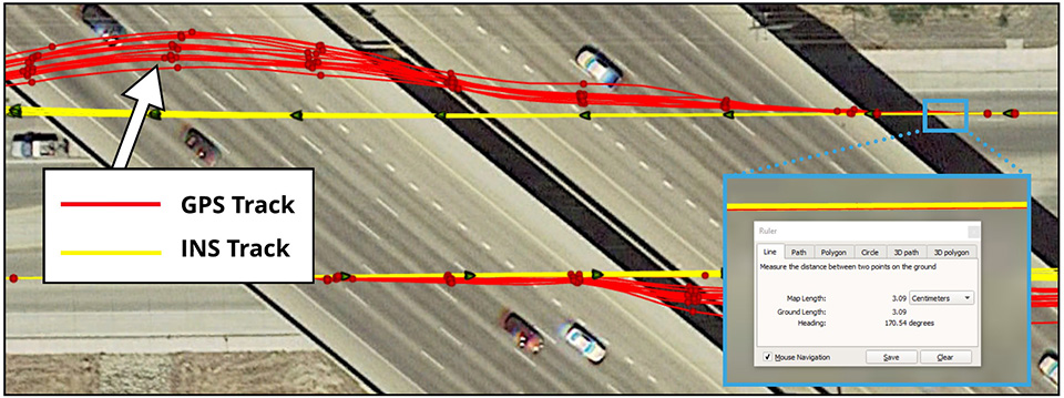
In the image above, a vehicle travels under an overpass. The 3-cm accurate RTK-inertial navigation track holds true to the vehicle’s position while the standard GPS signal is lost. (Image: Inertial Sense)
“The incredibly small size of our new micro INS with RTK sensor, in combination with its extremely affordable price point, will make this type of highly sophisticated technology accessible for general consumer applications for the very first time,” said Walt Johnson, founder and CTO, Inertial Sense. “We are offering RTK at a size, accuracy and price point that the market has never seen before.”
By optimizing the manufacturing processes for high volume applications, the micro INS with RTK sensor is as small and lightweight as a dime, and is available at a low price point.
Sensor fusion. Sensor data from MEMs gyros, accelerometers, magnetometers, barometric pressure and u-blox GPS/GNSS are fused to provide optimal position estimation. Data out includes angular rate, linear acceleration, magnetic field, barometric altitude and GPS time.
The miniature module provides orientation, velocity and position. Base station corrections data can be applied to achieve centimeter-level precision.
Autonomous vehicles. The sensor will enable the navigation of all types of autonomous vehicles with a very high degree of precision, Inertial Sense said.
Inertial Sense patented modules are currently being sold worldwide at volume for a broad variety of applications including:
Aerial surveys: UAV Payloads for 3D mapping, photogrammetry, orthomosaics
Gimbal stabilization and antenna pointing
3D motion capture and personnel tracking
Evaluation kits. Inertial Sense has bundled evaluation kits it says are simple to use and contain everything needed to begin logging RTK-accurate data. The evaluation boards can be utilized in both rover and base station configurations and include 900-mhz radios with onboard logging capabilities.
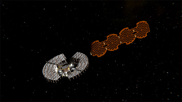
Satellite NTS-3 above Earth. (Illustration: Lt. Jacob Lutz, AFRL Space Vehicles Directorate)
Harris Corporation has been selected as the prime contractor to build Navigation Technology Satellite-3, the next-generation experimental positioning, navigation and timing (PNT) spacecraft. The satellite, called NTS-3, is expected to launch in 2022, with one year of experimental operations.
The Air Force Research Laboratory and the Space and Missile Systems Center selected Harris on Dec. 20, 2018, and announced it on Jan. 17.
PNT Testbed
As a unique testbed in geosynchronous orbit, NTS-3 will integrate several advanced technologies to demonstrate resiliency and new concepts of operation to include experimental antennas, flexible and secure signals, increased automation, and use of commercial ground assets.
Technologies matured and knowledge gained from NTS-3 are expected to transition to future generations of GPS and augmentation layers for national PNT capabilities.
Satellite NTS-3 closeup. (Illustration: Lt. Jacob Lutz, AFRL Space Vehicles Directorate)
“The National Defense Strategy tells us we must evolve our nation’s Position, Navigation, and Timing capabilities to be more resilient,” said AFRL Space Vehicles Director Col. Eric Felt. “NTS-3 is all about resiliency, and I am incredibly excited about the resiliency experiments our SMC, AFRL, and Harris team will be able to conduct with NTS-3’s innovative and flexible hardware, software, and waveforms.”
Agile Waveform Platform
In support of NTS-3, Harris plans to develop the Agile Waveform Platform, a digital signal generator that can be reprogrammed on-orbit, enabling operators to quickly develop and deploy new signals to meet rapidly-evolving needs on the battlefield.
Additionally, Harris’ electronically steerable phase-array antenna will support simultaneous broadcast of multiple waveforms in both Earth-coverage and spot-beam configurations.
NTS-3 will use Northrop Grumman Innovation System’s ESPAStar bus, building on AFRL’s EAGLE spacecraft that launched in April 2018.
The NTS-3 Space Experiment
Navigation Technology Satellite – 3 (NTS-3) was selected as the Space Vehicle Directorate’s next major integrated space experiment in 2015, and it represents AFRL’s first PNT flight experiment to prototype a more resilient PNT multi-layer architecture in accordance with the Space Enterprise Vision (SEV) and the Space Warfighting Construct (SWC).
Satellites NTS-1, 2 and 3. (Illustration: Lt. Jacob Lutz, AFRL Space Vehicles Directorate)
NTS-3 builds on a heritage of Department of Defense (DoD) satellite navigation (SATNAV) success that began in the 1970s with the predecessors of the modern GPS constellation. NTS-1 was developed by the Naval Research Laboratory (NRL) and launched in 1974 with two rubidium-vapor frequency standards that advanced the timing and navigation precision demonstrated by the earlier TIMATION satellites.
NTS-2 launched in 1977 as the first NAVSTAR GPS Phase I satellite, and demonstrated cesium frequency standards and a worldwide network for data acquisition. There has been no major DoD SATNAV developmental program for experimentation since then, until NTS-3.
In 2017, AFRL restructured NTS-3 to emphasize mission objectives to demonstrate disaggregated, resilient PNT in a multi-layer space architecture, as outlined by the SEV and the SWC. NTS-3 will provide space qualification for core technologies such as on-orbit digital signal reprogrammability and solid-state amplifiers. In addition to new signals, onboard experiments include improvements to timing accuracy and integrity, including ensembling to improve long- and short-term stability. NTS-3 will demonstrate key tactics, techniques and procedures (TTPs) for multi-layer PNT through all three segments of the SATNAV system: space, control, and user.
Ground Control
Braxton Technologies was selected in June 2017 to handle NTS-3 SATNAV ground control, while demonstrating and maturing innovative and affordable ground-based command and control capabilities to ensure resilient PNT in contested and denied environments.
Braxton experts also will demonstrate satellite ground-control technologies to inform future GPS ground-control systems. They will use the Multi-Mission Space Operations Center (MMSOC) open architecture standard, as well as the Air Force Satellite Control Network (AFSCN) for primary direct and secure communications with the future NTS-3 space payload.
Satellite NTS-3 in space. (Illustration: Lt. Jacob Lutz, AFRL Space Vehicles Directorate)
Ground control segment (GCS) objectives include commanding of multiple antennas to form high-gain regional beams in conjunction with traditional Earth coverage beams, and processing the subsequent impact on phase center bias and pattern variation.
The GCS will also incorporate commercial antennas for TT&C and experiment with automation of common functions to reduce the level of manual control that GPS requires. GCS development will emphasize cyber security and compatibility with Enterprise Ground Services (EGS).
Collaborators Wanted
AFRL/RV is seeking collaboration from industry, government agencies, and universities in developing experimental concepts and participating in the flight experiment.
MAGNET Collage Web version 1.3 is designed to allow operators to work with more types of data with greater flexibility, including the ability to import BIM models, as well as CAD and GIS data, the company said.
MAGNET Collage Web and MAGNET Collage desktop software meet the demands of a diverse user-group. The latest update is designed to address an increasing need from the vertical building construction market segment to work in a single-software environment with BIM, scanning, and UAV datasets.
“Now operators can view and publish BIM models, along with other data types, directly through the web browser to be sharable with more versatility,” said Alok Srivastava, director of product management. “MAGNET Collage Web can be used to overlay as-built laser scans and design data to visualize proposed changes and detect construction issues. The software supports OBJ, FBX and 3DS formats.”
The upgrade to MAGNET Collage Web also includes new direct publishing functionality for CAD and GIS data files through the browser.
“Operators can now overlay 3D point clouds and reality models with CAD and GIS design data, including support for DXF, SHP, KML, GML and GeoJSON formats,” said Srivastava.
The upgrade to MAGNET Collage Web also introduces advanced sharing controls including the ability to fully customize layer visibility, appearance, window layout, feature selection, and camera position.
“The updated customization controls allow operators to share and present their projects exactly the way they mean to with a multitude of viewing options, allowing specific features to be highlighted as necessary,” said Srivastava.
Additionally, MAGNET Collage Web can now be accessed through the Topcon “Blue Bar” that allows direct access to the service from any Topcon website. The universal account and application management toolbar is embedded at the top of Topcon web pages.
The European GNSS Agency (GSA) is organizing a public consultation on the Integrity & Reliability of Digital Maps for Connected and Automated Driving, in connection with the recently published Commission Communication on Connected and Automated Mobility.
This communication addresses the need to investigate the integrity and reliability of digital maps in order to facilitate the deployment of fully automated and connected vehicles.
Image: GSA
Digital maps are an essential building block to ensure a safe driving experience for highly automated driving and autonomous vehicles. Purpose-built maps will be produced that will be much more reliable and accurate than those used for traditional applications.
These digital maps will be enriched with information from public databases and sensor data from connected vehicles. Traffic information, such as speed limits or the real-time dynamics of traffic flow, will help the vehicle’s navigation system to anticipate upcoming road conditions and take decisions beyond what is enabled by the vehicle’s on-board sensors.
Key role for GNSS
Satellite navigation (GNSS), and in particular Galileo, plays a key role in providing precise and secure positioning in vehicle navigation technologies for driverless mobility. Moreover, GNSS is the primary sensor for building digital maps to provide very accurate positioning together with other sensors, such as LiDAR, for example.
Dynamic data pose specific problems, particularly given their real-time nature: they must be generated, validated and made available to the user equipment without delay. This makes their integrity validation more challenging, and their transmission can be subject to errors or disruptions affecting the overall reliability.
Addressing the issue
Currently, it is the navigation and map provider’s responsibility to ensure the integrity of its products and the reliability of the information provided by third-party suppliers. However, until now the maps have been mainly used to support navigation, giving information to the driver, rather than to support safety-related functions.
Some industry standards exist or are being developed for data exchange and map content, but there are currently no specific standards or certification procedures to assess map data quality characteristics, such as reliability, integrity, and traceability. This public consultation is a starting point in addressing this issue.
Have your say
The public consultation can be accessed here. It will be open until Jan. 27.
The document contains the Galileo E6-B and E6-C codes specifications, including primary and secondary codes and their assignment to satellites, which is necessary for manufacturers who are developing Galileo E6-B/C enabled receivers.
The technical note represents the first step for these forthcoming Galileo services: high-accuracy service (HAS) and commercial authentication service (CAS) on E6-B/C signal.
Fugro has completed a landmark data acquisition campaign over the Turks and Caicos Islands, marking the first commercial success of its new Rapid Airborne Multibeam Mapping System (RAMMS).
Working under contract to the United Kingdom Hydrographic Office (UKHO), the company acquired more than 7,400 square kilometers of integrated, high-resolution bathymetric, topographic and image data. The resulting deliverables will support updated nautical charts and coastal zone management activities in the region.
Launched in August 2018, RAMMS is a highly efficient, next-generation airborne bathymetric mapping system that uses multibeam laser technology to deliver depth penetration and point densities, the company said. The compact sensor is deployed from small aircraft and can be integrated with other remote sensing technologies for simultaneous collection of multiple complementary datasets.
For the Turks and Caicos project, this approach made it possible to acquire near-shore (bathymetry) and coastal (topography and imagery) data in a single deployment, producing a cost-effective solution and advancing Fugro’s sustainability goals by significantly reducing fuel consumption.
“After years of development, it’s extremely gratifying to operate RAMMS commercially and to demonstrate to clients the value that this cutting-edge technology can bring,” said Mark MacDonald, Fugro Americas Marine Division hydrographic service line director.
He pointed to the massive Turks and Caicos project as an example. “The system’s multibeam lidar capability allowed us to achieve point densities that otherwise would have required vessel-based surveys. With RAMMS, we were able to avoid that additional time and expense, and significantly reduce health and safety exposure.”
Fugro is working on three additional RAMMS projects in the Americas region, one for UKHO in Belize, and two for the Canadian Hydrographic Society, in Quebec and Atlantic Canada. These projects are similar in scope to that of the Turks and Caicos project, combining bathymetry, topography and imagery for maximum value to clients, serving both navigation and coastal applications.
Based on steady interest in RAMMS, Fugro and technology partner Areté Associates are building an additional system to meet anticipated contracting volumes in 2019.
Fugro is also finalizing a cloud-processing capability, which will further improve client delivery by streamlining data review and approvals, and ultimately making data available for download-on-demand.
Additionally, Fugro aims to operate the unmanned aerial vehicle-proven system autonomously in 2019, providing further operational efficiency gains and increasing access to remote project areas.
Guest column by Peter Fairhurst, Director, Product Line Management, Product Center Positioning, u-blox
Peter Fairhurst, Director, Product Line Management, Product Center Positioning, u-blox. (Photo: u-blox)
A new generation of GNSS hardware and pioneering new correction data services are enabling cheaper, more compact and truly scalable high-precision GNSS solutions, ready for the mass market.
High-precision GNSS as employed by specialized markets for more than a decade isn’t aren’t suitable for mass-market autonomous vehicles or other mainstream use cases. As well as being big, heavy and expensive, traditional high-precision GNSS systems don’t scale, which is a critical shortcoming when you consider this capability may very soon need to be built into every car that gets built.
To overcome these challenges, we’re seeing two complementary things coming to market: a new generation of GNSS hardware, and pioneering new correction data services. These two key facets combine to enable cheaper, more compact and truly scalable high-precision GNSS solutions, ready for the mass market.
A new generation of GNSS correction service forgoes the two-way link between customer device and the correction data service that is a hallmark of traditional high-precision GNSS corrections. Instead of sending each device its own, location-specific GNSS correction data, the new-generation services create a real-time model of relevant errors across their entire territory. They broadcast this over satellite and/or the Internet for customer devices to pick up.
Transmitting modeled GNSS error data to receivers across an entire region – as opposed to maintaining a two-way link with each and every device – opens the door to large-scale, mass market applications of high-precision GNSS
The shortcomings of traditional high-precision positioning
Correction data has long been key to high-precision GNSS services. In traditional applications, the customer’s positioning device detects its approximate location and sends this information to its correction service provider. This provider uses a network of base stations to monitor GNSS errors, comparing the readings calculated from the satellite signals to the stations’ known, fixed positions. It uses these insights to send the customer’s device tailored correction data, based on its location.
The technology has successfully been used to provide centimeter-level accuracy in surveying, agriculture and machine control, but annual subscriptions of sometimes more than $1000 per device mean it’s remained confined to specialized markets.
Moreover, traditional correction data services typically only operate in one country, or even one state. While this may not be an issue in some applications (such as localized agriculture), there are other use cases where limited range is a major problem. Imagine, for example, that you regularly need to travel across a state or national boundary in your (semi-) autonomous vehicle, or carry out remote UAV-based surveying in another country: maintaining your high-precision positioning capability is likely to mean roaming contracts and other extra costs.
The other issue with these traditional services is scalability. They use two-way cellular communication to pass data back and forth between the customer device and the correction data provider. And while this works when device density is relatively low, if this number grew to thousands or even millions of end-user pieces of kit trying to access the correction data service, current cellular infrastructure would struggle to deliver the required reliability. Particularly in safety-critical applications, where losing access to the correction data service could put lives at risk, this is unacceptable.
Image: u-blox
Recent developments in high-precision positioning
The new generation of GNSS correction services, creating and broadcasting a real-time model of relevant errors across their entire territory, over satellite and/or the internet for customer devices to pick up, opens the door to large-scale, mass-market applications of high-precision GNSS. Technology using State Space Representation (SSR) is one flavor of these new-generation GNSS correction data services.
Japan has led the way in GNSS error-broadcasting, using the L6 signal of its QZSS satellite network as a proving ground for mainstream use of the approach. Although it’s currently only available within Japan, the Centimeter Level Augmentation Service (CLAS) is generating a lot of interest across the automotive, agricultural and machine-control industries. Mitsubishi Electric, for example, used the CLAS service to field-test its autonomous driving system.
In China, Qianxun Spatial Intelligence Inc. is pioneering a different technique. Instead of broadcasting the data, Qianxun SI is leveraging its special access to the Chinese GNSS reference base stations to push the boundaries of what’s possible using the traditional technique. It provides tailored correction data services to customers including individuals, system integrators and original equipment manufacturers (OEMs). While it’s been a success in China, the approach is less appealing to OEMs who ship worldwide, because it requires their clients to arrange their own, local GNSS correction data.
Another important advance has been the rise of multi-band GNSS receivers, which enhance standalone positioning accuracy, thereby delivering a better customer experience in a variety of use cases. However, even multi-band receivers can’t achieve the centimeter-level accuracy that mobile robotics and autonomous vehicles need: these devices will always need to be complemented by some form of correction service.
Continent-wide GNSS correction data
Particularly in Europe, where there’s a lot of cross-border travel and economic activity, the simplicity of continent-wide GNSS correction services would offer enormous value. Sapcorda, for example, a recently launched joint venture between Bosch, Geo++, Mitsubishi Electric and u-blox, is creating a next-generation GNSS correction data service with coverage on a global scale (Europe, North America, etc), building on the lessons learned in Japan.
Sapcorda will broadcast right across the continent, using cellular networks as well as over satellite links. Customers won’t be tied to a specific GNSS manufacturer. Data will be distributed in an open format, so that device-makers can create exactly the solutions their customers want.
Having access to GNSS correction services continent-wide has the potential to transform high-precision positioning into a mainstream offering, supporting various IoT applications, as well as drones and (semi-) autonomous vehicles.
Addressing the remaining challenges
High-precision GNSS correction services that target the mass market are still relatively new, with different suppliers pursuing different business models. Trimble’s service, for example, doesn’t use an open correction-data format, and is only compatible with devices using its own GNSS receivers. The benefit of this is that it can deliver a seamless, fully integrated solution, with complete interoperability across the Trimble product range (provided the region in question has good coverage). OEMs with customers is geographically broader markets will need to weigh this up against the benefits of global coverage provided by a range of correction-data suppliers offering open-format data.
As we touched on earlier, in safety-critical applications where location-accuracy is essential, any correction data service must be up to the task. This includes ensuring data broadcasts aren’t crowded out when cellular networks become saturated. To this end, u-blox has been working with the 3GPP body to create appropriate standards that can ensure the service meets the required service level agreements.
Lastly, although there’s now country-wide coverage in both China and Japan, Sapcorda is now attempting to provide continent-wide high-precision services. If it’s a success, it could overcome the challenges of national boundaries and country-based cellular providers. It’s as yet unclear how existing correction-data-service suppliers will respond.
Customer satisfaction is paramount
For high-precision GNSS services to achieve mainstream success, they not only need to offer wide coverage and be truly open, but must facilitate innovation and ensure they can broaden the appeal of this capability beyond being a niche specialism. Like in any industry, customer satisfaction is essential if the technology is to achieve this.
Complexity that arises as a result of state boundaries, national borders, conflicting regulations or subscriptions, must be shielded from the end user and dealt with upstream. This is already happening in some areas, where device-makers are partnering with correction data service providers, enabling them to bundle the service cost into the device cost that the end user pays.
A revolution in positioning
As well as helping to realize some of the automated navigation solutions currently under development, new-generation high-precision GNSS services are driving a seismic shift across the whole industry.
The rise of innovative, high-precision GNSS technology, combined with business models that promise to make high-precision a mass market reality, mean the coming years will be tremendously exciting. By disrupting the existing market, the new technology will mean lots of new opportunities for those ready to grasp them.
Peter Fairhurst joined the Product Strategy team in the Product Center Positioning at u-blox AG in 2015. He is responsible for the development of industrial markets, with a specific focus on unmanned systems and mapping solutions. Prior to u-blox, he was part of the Product Management group at Leica Geosystems AG, where his focus was on high-precision GNSS surveying technology.
Fairhurst holds a bachelor degree in Mathematics & Computer Sciences and doctorate degree in satellite geodesy from Newcastle University and an MBA diploma from the University of Strathclyde.
This digital elevation model (DEM) indicates the type of data currently being acquired across Florida. (Photo: Dewberry)
High-resolution airborne lidar data to be acquired over 34,000 square miles for disaster response and recovery.
Under an active Geospatial Products and Services contract, the U.S. Geological Survey (USGS) has selected Dewberry, a privately held professional services firm, to complete a statewide lidar mapping project for Florida. The project is funded by the Florida Division of Emergency Management and USGS as part of Hurricane Irma Disaster Recovery, Response and Preparedness measures being conducted by the state and federal agencies.
The approximately $20 million project includes airborne lidar data acquisition, ground survey and preparation of bare earth point cloud and digital elevation model products for various applications to support response, recovery, and preparation for future storm events.
The resulting quality level 1 data will be primarily used for hydrologic and hydraulic modeling and many engineering applications by the water management districts to mitigate the impacts of flooding caused by these storms.
USGS and the Federal Emergency Management Agency (FEMA) will also utilize these data for various flood studies. The project encompasses an area of more than 34,000 square miles.
Photo: Dewberry
Dewberry has acquired and processed nearly 22,000 square miles of lidar data for various local, state, and federal agencies in Florida within the past three years.
“As we continue to map the state of Florida, we’re looking forward to using the best technology and personnel to complete such a vast undertaking,” said Dewberry Vice President and Director of Remote Sensing Amar Nayegandhi, CP, CMS, GISP. “Once these data are acquired and analyzed, they will be able to support USGS, FEMA, the Natural Resources Conservation Service, the Florida water management districts, and several other state and local agencies in their mission to better prepare for natural disasters and minimize loss of life and property; and use these scientific data to enhance and protect our quality of life.”
Dewberry will serve as prime contractor for this project and will perform the majority of the data production. The firm is teaming with seven other partner firms including Woolpert Inc., Quantum Spatial Inc. and Digital Aerial Solutions, Inc, which will acquire and process data to support the project.
Dewberry’s other subcontractors will be tasked with acquiring airborne lidar data.
“We have 11 aircraft with top-of-the-line airborne lidar sensors being deployed for data acquisition starting in early December,” said Dewberry Senior Project Manager Elise MacPherson, PMP. “I’m excited to manage this project and support the needs of USGS, their partner federal agencies and the many stakeholders in Florida.”
Enhancements include flexible pricing and easier app deployment experience
Esri has implemented major changes to ArcGIS for Developers, providing an enhanced mapping experience that the company says is more accessible and affordable.
These changes include a new pay-as-you-go plan for all of Esri’s location-based services, a decrease in the price of routing transactions and a new commercial app deployment experience for developers, the company said.
ArcGIS for Developers. (Photo: Esri)
This new experience brings the power of mapping to all developers and provides greater simplicity and flexibility. Esri has introduced a new monthly payment structure for the Builder plan in its developer subscription. The Builder plan is now offered at a monthly subscription rate of $125.
Esri has also introduced a 10 percent discount on existing annual Builder plan subscriptions. Customers who currently have an annual Builder plan subscription can continue to pay annually or switch to paying monthly.
“In addition to our existing subscription plans, we have introduced a new pay-as-you-go model that enables developers to pay only for services and transactions that they use,” said David Cardella, Esri product manager for developer technologies. “Developers can now access dozens of different maps from our Living Atlas, store their data securely, route, and geocode, as well as create and deploy apps with much greater ease and efficiency.”
Esri has additionally included a commercial app deployment license in all paid developer subscription plans (Builder plan and higher) at no additional cost. The price of routing services has also been reduced from $4 to $0.50 per 1,000 routes. This price decrease is applicable to all ArcGIS users, including the developer community.
ArcGIS for Developers offers a full suite of developer tools and development resources to build mapping and analytics solutions to support business needs. Developers use ArcGIS APIs to create location-based web and native applications for desktop and mobile devices.
The new enhancements and changes now give developers greater freedom to build, manage, and deploy apps as quickly as possible by allowing them to use the specific tools they need, when they need them, priced to fit their individual needs.
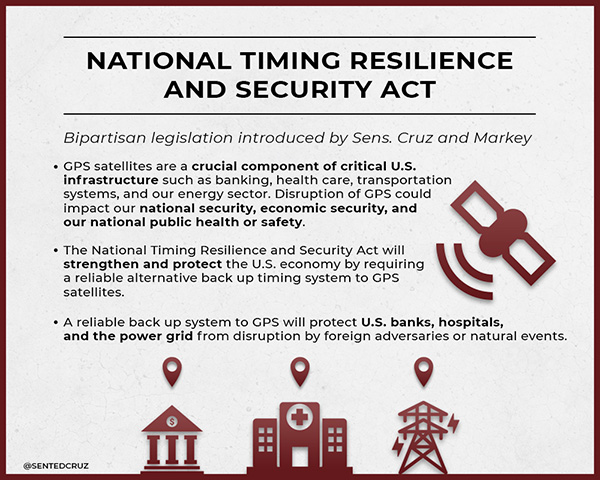
Most observers missed the $5 million for a GPS backup technology demonstration in the U.S. Department of Defense appropriation passed in September. Congressional staff say it is included in an obscure research and development line item for “Electronics and Electronic Devices.”
This funding is in addition to the $10 million Congress provided for the project last fiscal year (note: since these are R&D funds, the monies remain available for three years after they are appropriated).
This additional funding is part of Congress’ long but accelerating march to establishing a terrestrial PNT system to backup and complement GPS, an effort with which the administration is struggling to keep pace.
Image: @SENTEDCRUZ
Members in both the Senate and House were surprised and concerned in 2009 when the Obama administration suddenly went against the advice of its departments, national advisory board, and virtually every technologist and engineer in government. That is when the administration decided to terminate plans to convert the old Loran-C system to eLoran as a complement and backup for GPS.
Congress’ concern was not completely allayed when, in a report Congress had mandated, the administration said that a wireless GPS navigation backup was not needed. Users could easily resort to paper maps and charts. The same report did admit that the need for wireless precise timing was another issue. The administration said it would study this, even as the Loran-C system was being terminated.
Subsequent hearings in Congress revealed ongoing concerns about the lack of a terrestrial capability. These were magnified by the nation’s major adversaries, Russia and China, retaining terrestrial Loran systems to inoculate themselves from the effects of disruptions to their space-based PNT systems.
More mixed signals from administration officials amplified Congress’ concerns and frustrations. These included:
The Department of Defense committing to establishing a terrestrial backup for GPS within the United States, then reversing its position just before its authorization bill was finalized. This reversal was not based upon technical or national security grounds; rather, that it “wasn’t the department’s job.” This reversal nullified almost two years of coordination and effort by Congressional members and staff.
A senior Department of Defense official at a hearing providing grossly inaccurate information about GPS resilience and backup systems. The official subsequently retired.
The Deputy Secretaries of Defense and Transportation in 2015 promising action to the chairman of the House Transportation Committee. In a December letter they said the administration would establish a GPS backup by first establishing an eLoran timing system, and then an eLoran navigation system. Aside from signing the letter, no further action was taken.
Congress’ growing skepticism about administration positions on this has led to a series of hearings, informal inquiries, demands for reports, and legislation. Together they chart a very deliberate effort to bypass bureaucratic infighting and confusion as much as possible en route protecting the nation with a terrestrial complement and backup for GPS.
Legislative action has included :
in 2015, halting demolition of Loran-C infrastructure pending a decision on a GPS backup system. (USCG Authorization Act)
in 2016, requiring the departments of Defense, Homeland Security and Transportation to identify requirements for a domestic GPS backup and report before the end of 2017. (National Defense Authorization Act/ NDAA)
in 2017, requiring a plan for a GPS backup technology demonstration by April 2018, completion of the project by June 2019, and authorizing $10 million for the program. (NDAA)
in March 2018, providing $10 million for the GPS backup technology demonstration (DoD Appropriations)
in August 2018, reaffirming Congress’ interest in the backup demonstration, requiring a progress brief by Dec. 1 2018, and authorizing another $5 million for the project (NDAA)
In September 2018, funding an additional $5 million for the backup demonstration (DoD Appropriations)
In December 2018, the National Timing Resilience and Security Act of 2018 was signed into law. It directs the Secretary of Transportation to establish a terrestrial, difficult-to-disrupt, wireless timing system to provide backup capability for GPS. A report on requirements and an implementation plan are due in June 2019, and system operation is mandated by December 2020.
Contacts with members and staff in the new, 116th Congress show that interest in this topic has increased. So has frustration with the administration missing many, if not most, of its deadlines for reports and briefings.
A recent GAO report that U.S. weapons systems are vulnerable to GPS spoofing; the need for a strong navigation and timing infrastructure for autonomous vehicles, drones, and intelligent transportation systems; and continued high visibility instances of deliberate GPS jamming and spoofing are all adding to concerns.
Also of note, Congressman Peter DeFazio (D-OR) has been named chairman of the powerful House Transportation and Infrastructure Committee. Rep. DeFazio has long believed in the need for action to provide a backup capability for GPS.
Congress is clearly set on a determined course. Perhaps the administration will catch up before it earns more of the Congress’ ire, and before a major disruption demonstrates the consequences of inattention to the entire nation and the world.
Lockheed Martin has received a $172 million contract from the U.S. Navy and Air Force for Long Range Anti-Ship Missile (LRASM) production. The LRASM is designed to reduce dependence on GPS.
The contract continues the production for the air-launched variant of LRASM, including a full production run of missiles and engineering support. This is the second of several expected annual production lots that will deliver next-generation anti-ship missiles to the U.S. Navy and U.S. Air Force.
LRASM is designed to detect and destroy specific targets within groups of ships by employing advanced technologies that reduce dependence on intelligence, surveillance and reconnaissance platforms, network links and GPS navigation in electronic warfare environments.
LRASM will play a significant role in ensuring military access to operate in open ocean/blue waters, owing to its enhanced ability to discriminate and conduct tactical engagements from extended ranges.
LRASM is a precision-guided, anti-ship standoff missile based on the successful Joint Air-to-Surface Standoff Missile – Extended Range (JASSM-ER). It is designed to meet the needs of U.S. Navy and U.S. Air Force Warfighters in contested environments.
The air-launched variant provides an early operational capability for the U.S. Navy’s offensive anti-surface warfare Increment I requirement. With the recent EOC declaration by the U.S. Air Force for the B-1B, the focus is now on the U.S. Navy’s F/A-18E/F Super Hornet in 2019.
“LRASM brings a game-changing capability to both the U.S. Air Force and the Navy,” said David Helsel, LRASM director at Lockheed Martin Missiles and Fire Control. “This second production lot will provide anti-ship missiles for both the B-1B and F/A-18E/F, bringing sea control back to our warfighters.”
Features include enhanced ADS-B, SBAS and georeferenced charts.
Collins Aerospace’s Pro Line Fusion avionics upgrade for Pro Line 4-equipped Bombardier Challenger 604 series aircraft has been certified by the U.S. Federal Aviation Administration (FAA).
Working closely with Bombardier as the original aircraft manufacturer and Nextant Aerospace as the installation design certification lead, this sole all-in-one solution complies with pending mandates while modernizing the flight experience for pilots.
The Pro Line Fusion upgrade enhances the operational capabilities of the Challenger 604 aircraft to a similar level as that of the Challenger 605 and Challenger 650 jets equipped with Collins Pro Line 21 Advanced, while providing Challenger 604 operators with a solution to meet future regulatory requirements.
Among these enhancements, the upgrade replaces the factory-installed CRT displays with three 14.1-inch widescreen LCD displays with configurable windows. Features designed to improve situational awareness and reduce pilot workload for Bombardier Challenger 604 aircraft owners include:
A fully loaded package of baseline equipment for operation in modernizing global airspace — beyond ADS-B mandate compliance, offering SBAS-capable GNSS, localizer performance with vertical guidance (LPV) approaches, radius-to-fix (RF) legs and more
Geo-referenced electronic navigation charts that display own-ship aircraft position
The Challenger 604 Pro Line Fusion retrofit solution, which is already available for several Beechcraft King Air and Cessna Citation CJ aircraft, is part of our ongoing effort to provide owners with modern technology, enhanced situational awareness and compliance with airspace mandates,” said Christophe Blanc, vice president and general manager, business and regional systems for Collins Aerospace. “The Challenger 604 business jet is a highly-valued, long-haul aircraft that will be able to continue flying well into the future with this upgrade.”
The upgrade is available exclusively throughout Bombardier’s extensive network of service centers and Nextant Aerospace.