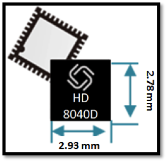
Allystar Technology Co. Ltd. has launched a multi-band, multi-GNSS system on chip, the HD8040 series, to help portable devices save size and weight. The HD8040 offered in wafer-level chip-scale packaging (WLCSP).
The HD8040 series of chipsets fully supports all civil signals on the L5 band, said Shi Xian Yang, Allystar high-precision product manager at Allystar. Besides GPS, other constellations with L1/L5 signals include Galileo, BeiDou, the Indian NavIC system and Japanese QZSS.
Besides L1 band, HD8040D supports L5/B2a/E5a signals, which are expected to have lower noise and be better in multipath mitigation mainly due to the higher chipping rate of L5 signals relative to L1 C/A code.
HD8041D supports IRNSS (NavIC), which makes it suitable for navigation in urban areas in India and the Middle East, where seven NavIC satellites have a higher elevation than both GPS and Galileo satellites. This means IRNSS (NavIC) would provide greater accuracy, precision and available measurements.
With the features of small size (3 x 3 millimeters) and low power consumption, the HD8040 series is suitable for smartphones, tablets and other portable devices.
The architecture integrates floating-point arithmetic units based on ARM CortexM4, 160 KB RAM, 32 KB backup RAM with VBAT, and 384 KB embedded Flash memory. Besides basic peripheral interfaces UART, I2C, SPI and GPIO, it supports the CAN interface for automotive applications, too.
Customer samples of the HD8040D and HD8041D are available now.
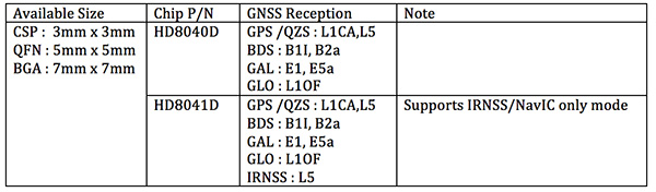
Tersus GNSS Inc. has released the Tersus GeoCaster, a Networked Transport of RTCM via Internet Protocol (NTRIP) caster software. The software expands the company’s product line and provides users with better and more comprehensive services.
The Tersus NTRIP caster software is designed to allow GNSS correction data such as RTCM corrections to be repeated and sent to different end users via the internet.
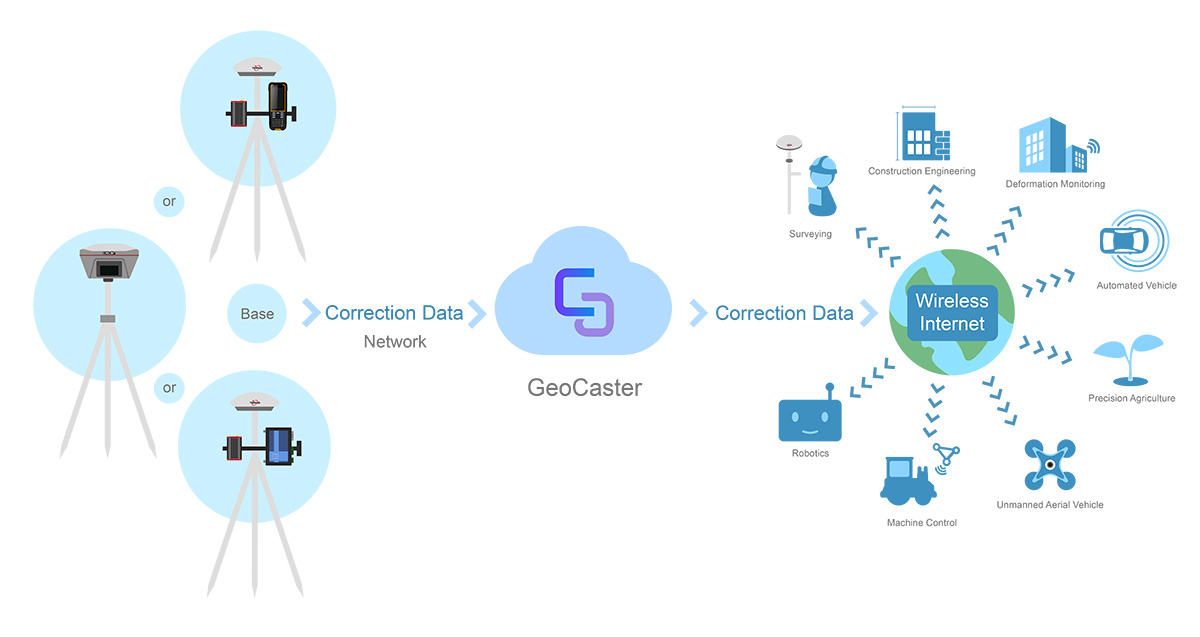
Screenshot: Tersus GNSS
“GeoCaster has a user-friendly interface, and it not only supports multiple bases online simultaneously but also supports multiple rovers for one base,” said Xiaohua Wen, founder and CEO of Tersus GNSS Inc. “Our users can have a real-time review of detailed statistics and can modify user-defined permissions manually.”
Tersus GeoCaster supports configurable bases online simultaneously and configurable rovers for one base. GeoCaster supports NTRIP protocol and operates continuously.
The software is designed for end users involved in applications such as surveying, construction engineering, deformation monitoring, automated vehicle, precision agriculture, unmanned aerial vehicle, machine control and robotics.
This is the first release of GeoCaster. Version 2.0, targeted at the first quarter of 2019, is expected to offer higher accuracy and longer baseline applications.
In April 2018, the Civil GPS Service Interface Committee (CGSIC) announced the Department of Homeland Security release of the memorandum titled “U.S. Owners and Operators Using GPS to Obtain Time,” which is intended to provide an understanding of the possible effects of the April 6, 2019, GPS Week Number Rollover on Coordinated Universal Time derived from GPS devices.
GPS users should review this memorandum and be aware of the potential impacts to their equipment when the GPS Week Number rolls over to 0 on April 6, 2019 / April 7, 2019.
If you have questions about how your equipment may be impacted by the GPS Week Number rollover, we recommend you contact your equipment manufacturer.
Bell Helicopter unveiled a full-scale vertical-takeoff-and-landing (VTOL) air taxi vehicle during CES 2019, held in Las Vegas.
The air taxi, named Bell Nexus, is powered by a hybrid-electric propulsion system and features Bell’s signature powered lift concept incorporating six tilting ducted fans designed to safely and efficiently carry passengers.
Bell Nexus means the nexus of transport and technology and of comfort and convenience. Nexus captures the long-sought-after vision of quick air travel with a unique in-flight experience, keeping passengers connected to their lives and saving valuable time.
The Nexus team consists of Bell, Safran, EPS, Thales, Moog and Garmin, who are collaborating on Bell’s VTOL aircraft and on-demand mobility solutions. Bell is leading the design, development and production of the VTOL systems; Safran is providing the hybrid propulsion and drive systems; EPS is providing the energy storage systems; Thales is providing the Flight Control Computer (FCC) hardware and software; Moog is developing the flight control actuation systems; and Garmin is integrating the avionics and the vehicle management computer (VMC).
Autonomous Pod Transport (APT). Alongside the debut of Bell Nexus, Bell will feature the Autonomous Pod Transport (APT). The APT family varies in payload capability that can serve many mission sets such as medical, law enforcement, offshore missions and on-demand delivery services. Bell is expanding into a new industry to show the full spectrum of our capabilities and the real-world challenges APT will address, Bell said in a press release.
Future Flight Controls. Bell’s Future Flight Controls simulator was a new experience for CES participants this year. Bell is actively collecting data to help shape the future flight controls of aviation. Data from the simulators will be used to determine what actions and interfaces are intuitive to the average potential operator and what prior experiences and abilities contribute to these opinions.
Urban air travel is coming closer to the masses through recent advancements in technology and software. The critical last step is designing a flight-control ecosystem that allows individuals to safely and efficiently operate urban air vehicles.
In 2018, Bell provided the world a glimpse into the air-taxi passenger experience, and this year, attendees could see the full vision.
A roundup of recent products in the GNSS and inertial positioning industry from the January 2019 issue of GPS World magazine.
OEM
RF front-end
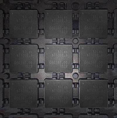
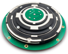
Application-specific integrated circuit (ASIC) FOR GNSS
Photo: NTLab
NT1066 is a four-channel RF front-end ASIC (three wideband IQ and one narrowband IQ) that covers all GNSS (GLONASS, GPS, Galileo, BeiDou, QZSS, NavIC) signals at all frequency bands, so users benefit from all the advantages of acquiring multiple system simultaneously. Channels A, B and C are designed with single-conversion low-IF architecture, individually programmable and intended to receive L1, E1, B1, E6, B3, L2, L3, B2, L5 and E5 in various combinations. IQ and image suppression modes are available. Channel D is dedicated to the S band of NavIC or L2, L3, L5 bands of GNSS and has zero-IF architecture. Combining channel D with channels A, B and C makes it possible to effectively eliminate ionospheric distortion using the large signal base of NavIC between the L5 and S bands. Alternatively, channel D can be software-reconfigured “on a fly” to receive real-time correction data transmitted over FM, VHF and UHF bands.
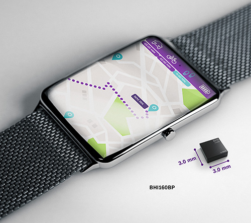
For smartwatches, fitness trackers and smartphones
Image: Bosch
The BHI160BP is a position tracking smart sensor for consumer wearables that uses integrated inertial sensors to improve GPS location tracking. When used with a GPS or GNSS module, it enables users to take advantage of pedestrian position tracking with up to 80% saving in system power consumption compared with a typical GNSS-only solution, without compromising on accuracy. The BHI160BP tracks a person’s position by intelligently applying an inertial-sensor-based algorithm for pedestrian dead reckoning. To maintain accuracy, it calculates the user’s relative location based on data collected from the inertial sensors and then recalibrates itself every few minutes to obtain the absolute position provided by the GNSS/GPS module. This means that the GNSS/GPS module can be kept in sleep mode for most of the time, which drastically reduces a device’s power consumption and extends its operating time.
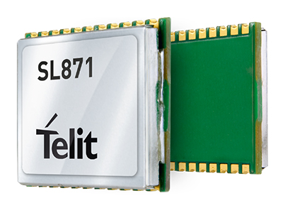
The SL869T3-I GNSS module combines GPS with India’s NavIC (IRNSS) navigation system and the country’s satellite-based augmentation system SBAS known as GAGAN. The SL869T3-I module enables the creation of high-performance position reporting and navigation solutions. It complies with Automotive Industry Standard 140 (AIS-140) — an Indian government mandate that requires the use of NavIC for vehicle location tracking devices in all public transportation vehicles, effective in April.
Technical information for defense and aeronautics applications
The Rohde & Schwarz Navigation and Guidance Solutions Learning Center now includes the latest Rohde & Schwarz solutions for GNSS testing. Updated material includes application brochures, white papers, articles, technical documents, training videos and products. Rohde & Schwarz provides accurate, flexible, high-performance test solutions, from design, development, calibration and production to operational maintenance for ground-based systems and advanced hybrid constellation simulations for GNSS systems. The navigation learning center also describes company products, including GNSS signal simulators.
The X-Survey antenna is a 4-in-1 OEM antenna for both navigation and communication in surveying applications. It provides standard Wi-Fi, Bluetooth and 4G, plus multiple constellation signal reception for GNSS positioning. The high-gain and wide-beamwidth GNSS antenna features a multi-point feeding technology, ensuring a high phase-center stability and positioning accuracy. Moreover, the array-arranged 4G antenna enables more stable signals and longer communication distance at 360-degree direction, increasing the overall machine efficiency over conventional antennas. The X-Survey antenna provides high isolation among each antenna to prevent self-interference, improving real-time kinematic (RTK) system compatibility. RF coaxial connectors are designed for plug-and-use, keeping high efficiency and lowering the impact of electromagnetic interference.
Mirrors capabilities of desktop version of global mapper
Image: Blue Marble
Version 20 of the Global Mapper Software Development Kit (SDK) is now available, along with the accompanying Lidar Module SDK. The developer’s toolkit provides software engineers with the means to embed the latest geospatial technology into custom applications.Highlights include dramatically improved vector data performance in both the 2D and 3D environments, updated 3D mesh rendering with colors now displayed in the 2D view, and faster display and export of online tiled datasets. The Global Mapper GIS application can display, convert and analyze virtually any type of geospatial data. The Global Mapper SDK and Lidar Module SDK provide software developers with a toolkit for accessing much of this functionality from within an existing or custom-built application.
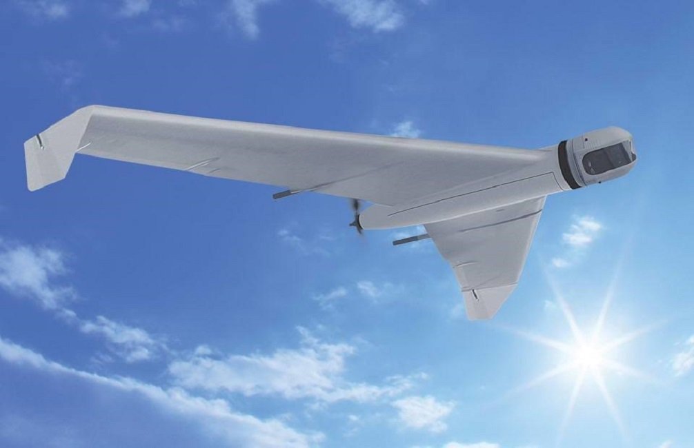
The ZALA 421-08M and ZALA 421-16E Artic UAVs are suited for operation at freezing temperatures, making it possible to carry out surveillance operations and regularly monitor the ice. Its GIRSAM alternative navigation system was developed for navigation of UAVs in the suppression or the absence of GPS or GLONASS signals. The ZALA Arctic’s capabilities facilitate oil and gas extraction planning in areas where accurate weather and ice situation forecasts are required.
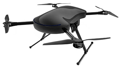
E-Drone Zero is a long endurance quadcopter managed by an advanced artificial-intelligence-powered operating system. The use of hydrogen fuel cells as the drone power source provides improved flight-time, less downtime due to quick refuelling, and increased payload capabilities. Advanced security is provided via NATO-validated military-level encryption. Additional safety features include computer vision assisted obstacle avoidance and various failure management features. Besides surveillance and security, e-Drone Zero is suitable for demanding survey, mapping and inspection tasks.
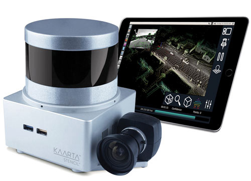
The Stencil 2 improves mapping accuracy and workflow with a new user interface compared to the original Stencil, as well as GNSS localization, upgraded hardware, confidence metrics and enhanced software intelligence. Stencil 2 ships with an iPad to access operations and view real-time scanning on the fly. It records GNSS data for use in loop closure to georegister and geolocate datasets, correcting for drift and improving the fidelity of large area scans. Kaarta offers an optional GNSS kit with Emlid Reach RS+ RTK GNSS receiver and custom mounting bracket. Alternatively, Stencil 2 integrates with other NMEA 0183-compliant GNSS systems.
Now type-approved by the U.S. National Marine Fisheries Service (NMFS) Office of Law Enforcement (OLE), the Addvalue iFleetONE-VMS provides commercial fishing vessels with a technologically advanced vessel monitoring system that satisfies regulatory requirements to routinely and securely report GPS positioning. The Addvalue iFleetONE-VMS, with its broadband capability, will enable fisheries management officials, biologists, researchers, analysts and NMFS Law Enforcement to have a cost-effective and suitable platform for applications that previously had been severely limited by available technologies.
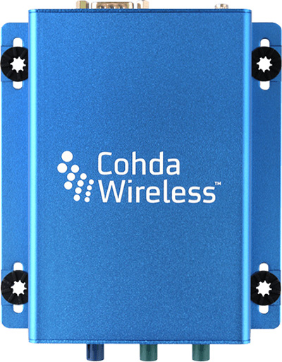
The MK5 On-Board Unit (OBU) is a fifth-generation low-cost, rugged module that can be retrofitted to vehicles for aftermarket deployment or field trials, and can also serve as a design reference for automotive production. The MK5 exchanges data at high speeds over extended distances, providing quick reaction times to potential hazards and safety-critical scenarios. Features include a dual IEEE 802.11p radio; a powerful processor running Cohda software applications; a GNSS receiver with lane-level accuracy; integrated security; hardware acceleration; and NXP chips with Cohda firmware. It supports DSRC (IEEE 802.11p), Wi-Fi (802.11a/b/g/n) wireless standards.
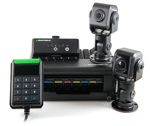
The SmartDrive SR3 and SR4 platforms provide a unified video and telematics data stream of time, location and driver and vehicle performance for third-party applications. Its single-box architecture and unified data stream eliminates redundancy across hardware, cellular connectivity, GPS modules, connections to the ECU and cabling. It also provides data alignment across the applications, unlocking new fleet performance insights and eliminating problematic data discrepancies.The platform provides analytics powered by SmartDrive SmartIQ; Geotab tracking, which delivers real-time and historical visibility to location, speed and geofencing information; Geotab regulatory compliance, including hours of service, driver vehicle inspection reports, International Fuel Tax Agreement (IFTA) recording and tax reports; and access and integration to Geotab Marketplace partners.
In his new book No One at the Wheel: Driverless Cars and the Road of the Future, Transportation expert Samuel I. Schwartz (who coined the term “gridlock”) describes how the driverless vehicle revolution will transform highways, cities, workplaces and laws across the globe. Every major car maker in the U.S., and abroad is working on bringing autonomous vehicles to consumers. The fleets are getting ready to roll and nothing will ever be the same; this book discusses what the future has in store. 272 pages, ISBN: 1610398653.
GPS Control Segment Sustainment II (GCS II) contract continues the modernization of the GPS Operational Control Segment (OCS).
The U.S. Air Force has awarded Lockheed Martin the GPS Control Segment Sustainment II (GCS II) contract to continue to sustain and further modernize the GPS constellation’s ground control system through 2025.
This is a follow-on contract to Lockheed Martin’s current GCS contract, awarded in 2013.
Under the GCS II contract, the continued upgrade of the GPS Architecture Evolution Plan Operational Control Segment (AEP OCS) will allow GPS’ legacy ground control system to support GPS III satellite on-orbit operations, developed under the GPS III Contingency Operations (COps) program.
SpaceX’s Falcon 9 rocket orbited the first GPS III satellite on Dec. 23, 2018. (Photo: SpaceX)
COps will enable the AEP OCS to support the positioning, navigation and timing missions of the Air Force’s new GPS III satellites, which began launching in December 2018.
In addition, GCS II will sustain the operational M-code capability being deployed in 2020 that is in development under the M-code Early Use (MCEU) contract. Operational M-code is a critical warfighter capability to support missions in contested environments.
Under the GCS contract, Lockheed Martin executed numerous engineering modifications to the OCS, including:
the COTS Upgrade 3(CUP3)/Ground Antenna Air Force Satellite Control Network (AFSCN) Interface Technology Refresh (GAITR) upgrade
the Remote Site COTS Network (RSCN) project
the GPS Information Protection Reinforcement (GIPR) project
the COTS Upgrade #2 (CUP2) project
Red Dragon Cybersecurity Suite (RDCSS).
These projects modernized the infrastructure, improved the cyber posture and added mission capability. The GCS II contract continues that commitment to evolving the OCS to address today’s mission needs.
Under GCS II, LM will continue to manage the technical baselines for the OCS and GPS Information Network (GIN) and regularly procure, develop, fabricate, integrate, test and install software and hardware modifications into the GPS operational baseline. Focus areas will be performing a technical refresh of the GIN and increasing the resiliency of the OCS.
“Lockheed Martin’s experience integrating GCS projects as well as the system engineering and software integration performed on GPS III Contingency Operations (COps) and M-Code Early Use (MCEU) position us well to deliver GCS II,” said Maria Demaree, vice president/GM Mission Solutions for Lockheed Martin Space. “We look forward to supporting the Air Force as it deploys the next generation GPS III satellites and their new capabilities for our warfighters.”
Advanced AI, robotics and autonomous vehicle services on Sprint’s dedicated IoT network will adapt to the real world using highly accurate, detailed and constantly refreshed maps.
Sprint and Mapbox are launching precision mapping technology with Curiosity IoT, allowing automated services that run on Sprint’s dedicated internet of things (IoT) network to move around the ever-changing world with pinpoint accuracy.
Smart machines, from drones to autonomous delivery carts, will be able to make fast location and routing decisions using highly detailed, accurate maps that are updated as the environment changes.
Sprint made the announcement this week at the Consumer Electronics Show being held in Las Vegas.
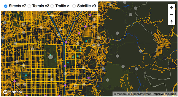
High Accuracy and Precise Detail with Live Maps. Mapbox offers what it calls a “live map”, a map built not from traditional data surveys months or years before, but from data collected from hundreds of millions of location-enabled sensors that feed back information about the world in real time.
Mapbox uses artificial intelligence (AI) to turn those massive data flows into a picture of real time transit paths that can be used for precise, up-to-date routing.
Image: Mapbox
Through its relationship with Sprint, Mapbox will leverage the inherent advantages of Curiosity IoT with 5G to take mapping to the next level. The network’s extreme bandwidth and low latency will allow Mapbox to collect higher volumes of richer data from the sensors, including high resolution video.
That data can be processed to identify and detect changes in the physical environment. Those changes are then incorporated into updated maps which can be distributed at scale to a wide variety of smart machines. The result is more accurate, more up-to-date maps that reflect the world in real time.
“Smart machine-based services need to be able to make immediate mobility decisions similar to the way a driver might react to construction, traffic or other obstacles on a street,” said Ivo Rook, senior vice president, IoT and product development at Sprint. “The launch of Mapbox’s precision mapping technology allows all intelligent machines to move at a level of precision never seen before. Our fully dedicated Curiosity IoT network and operating system — soon to be powered by Sprint’s mobile 5G connectivity makes this possible. From autonomous vehicles to advanced AI-based machines, precision mapping is a big step forward in making smart service models a reality for the immediate economy.”
“As maps guide new smart machines on IoT networks, you remove the human in the middle that used to compensate for differences between the map and the real world. Precision mapping services need to reflect the world as it is, at that precise moment so that those smart machines can travel safely and efficiently,” said Eric Gundersen, CEO of Mapbox. “Sprint’s Curiosity IoT network with mobile 5G provides platform services that make that real with high bandwidth, edge computing for object detection and data processing and super low latency.”
Curiosity IoT with 5G. Sprint 5G and Curiosity will create the new standard in IoT which features device data intelligence, over-the-air device management and chip-to-cloud security, the companies said.
When coupled with Sprint mobile 5G technology, Curiosity IoT’s dedicated, distributed and virtualized IoT core network is capable of supporting artificial intelligence, robotics, edge computing, autonomous vehicles and other IoT systems requiring extreme low-latency and high-bandwidth.
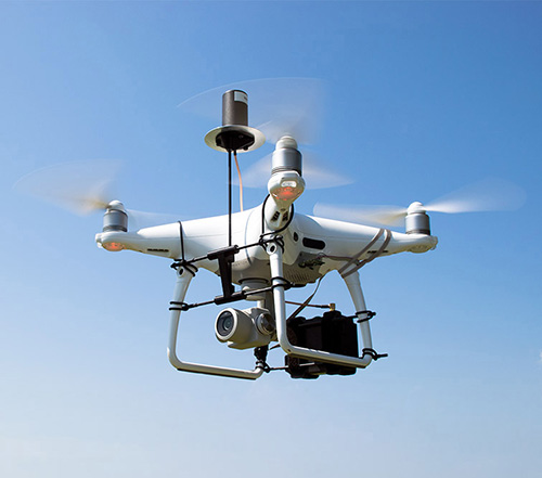
DJI Phantom 4 Pro with Loki PPK system. (Photo: GeoCue)
GeoCue Group (via its wholly owned AirGon subsidiary) has completed the integration of the DJI Phantom 4 Pro RTK (P4R) into its AirGon Sensor Processing Suite (ASPSuite).
ASPSuite is a post-processing solution for GeoCue’s Loki direct geopositioning system for DJI and other manufacturer’s drones.
ASPSuite enables integration of the P4R with third-party L1/L2 GNSS base stations such as systems from Septentrio, Leica, Trimble, Topcon, CHC and others in a high accuracy post-process kinematic (PPK) workflow.
In addition to PPK processing, ASPSuite includes support for options often required in engineering-grade surveys such as:
vertical transforms (such as ellipsoid to country-specific geoids)
creation of and transformation between collection datums and local coordinate systems (site calibration)
application of antenna static and dynamic lever arm corrections
full support for Loki direct geopositioning systems.
The DJI D-RTK-2 base station (optionally available) for the P4R can only be used in RTK mode, and then only if it is being sited on a known location. The D-RTK-2 does not currently allow access to an observation file, preventing it from being stationed using an online positioning service such as OPUS, AUSPOS, Canadian Geodetic Survey services and so forth. An additional consideration in the integration into ASPSuite is that professional surveyors already have the survey kit that they need incorporated into this workflow.
GeoCue is offering camera calibration services for the P4R for customers who wish to do minimal or control-free high-accuracy mapping projects (the DJI “calibration” is an image de-warping algorithm, not a proper photogrammetric calibration). A test of a GeoCue-calibrated P4R using an OPUS-positioned base station and ASPSuite achieved about 4-cm horizontal and 5-cm vertical network accuracy (RMSE) with no ground control points.
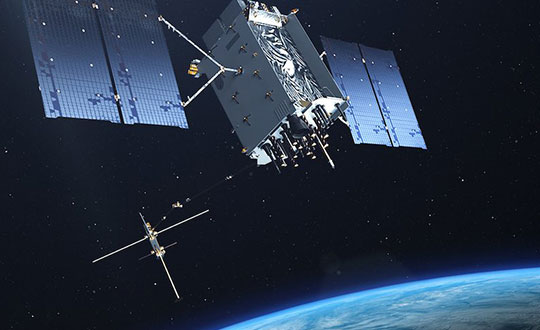
SpaceX’s Falcon 9 rocket orbited the first GPS III satellite on Dec. 23, 2018. (Photo: SpaceX)
On December 23, the first GPS III satellite entered an orbit around Earth, after a five-day delay. This first of a new breed of GPS satellite also experienced a four-year delay, with its original launch scheduled for 2014.
While the system has experienced more than its share of problems, at the start of a new year I want to focus on the benefits to come.
Few of us realized how much our lives would change when the first GPS satellite was launched in 1978. GPS III could bring about a similar trajectory of changes. Civilians can expect a more reliable and accurate service. The smartphone message “searching for signal” could become a dim memory.
GPS III signals will be three times more accurate than the current GPS Block II models. The navigation payload has more than three times reduction in range error and up to eight times increase in power — its signals should be much easier to pick up under tree canopy, within urban canyons and inside buildings.
GPS III also has four civilian signals. The L1C signal is interoperable with international GNSS, meaning users can receive signals from any country’s satellites. Also, using two civilian signals means GPS III can directly detect and correct ionospheric errors.
In addition to a standard wide-angle antenna for broad coverage, the GPS III satellites include a high-gain directional antenna that will operate with 100 times (+20 dB) the power of the wide-angle antenna, and will be exclusively for use with M-code (military) transmissions. This directional antenna’s spot beam covers an area 120 miles at high power— boosting the power of military GPS signals by 100 times in specific regions, making military GPS even harder to jam.
These advantages may not reach the battlefield for a decade. The new constellation will take time to build. The GPS III constellation is projected to be fully capable in June 2023, when 10 Block IIIA satellites are expected to be in orbit. Ten follow-on satellites are planned to be placed into orbit from 2026 to 2034.
Back here on Earth, equipment makers will need time to develop and supply warfighters with military GPS user equipment (MGUE) that can take advantage of all that GPS III has to offer.
Taoglas, a provider of internet of things (IoT) and automotive antenna and RF solutions, completed its acquisition of ThinkWireless Inc., an antenna provider that specializes in the design, development and production of combination antenna systems for the commercial vehicle market.
The ThinkWireless brand will become ThinkWireless, a Taoglas company. ThinkWireless Founder and Chief Executive Officer Argy Petros and Director of RF Technology Pierre Wassom will remain.
“Think Wireless has made a name for itself as a designer and developer of high-quality combination antenna systems with deep roots in the commercial trucking industry, where infotainment services, including good quality of service from satellite and AM/FM radio, weather band and GNSS are crucial,” said Ronan Quinlan, Co-CEO, Taoglas.
“As we continue to explore potential acquisitions to strengthen the Taoglas brand, we were struck by how similar Think Wireless’ approach to antenna design and manufacturing is to our own commitment to excellence,” Quinlan said. “This is a great acquisition for the Taoglas Group as we look to further expand into new, synergistic markets such as the commercial vehicle industry.”
ThinkWireless, headquartered in Coconut Creek, Florida, specializes in the design, development and production of combination antenna systems that incorporate two or more frequency bands, including those for SiriusXM satellite radio, GPS, AM/FM, weather band, DAB, HDTV, Wi-Fi, Bluetooth and LTE.
The ThinkWireless facilities will become Taoglas’ ninth design and development center globally, and the third in the U.S., alongside centers in San Diego and Minneapolis.
“Taoglas is well-known as a global brand that delivers the highest-quality antennas and RF solutions to the automotive, IoT and other markets,” Petros said. “Taoglas’ global scale and sales channels are unparalleled and will help grow the reach of ThinkWireless’ solutions in the trucking and commercial vehicle industry around the world.”
The ThinkWireless antennas will be available for purchase on the Taoglas website, through key distribution partners and through Taoglas’ Antenna Builder e-commerce marketplace for custom antennas and cable assemblies.
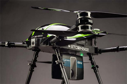
The Faro Focus scanner attached to a Stormbee UAV. (Photo: Stormbee)
3D measurement and imaging company Faro has joined with UAV provider Stormbee to offer an integrated airborne 3D scanning solution designed to quickly gather large area data for crash scene documentation, security pre-planning and military applications.
The integrated solution includes the Faro Focus laser scanner, the Stormbee S series UAV and the Beeflex software suite.
The airborne solution enables wide-area scanning missions, such as highways, train infrastructure, and buildings. While these would take days when scanned from the ground, they can now be completed in just hours without interrupting traffic or setting foot in a zone of interest.
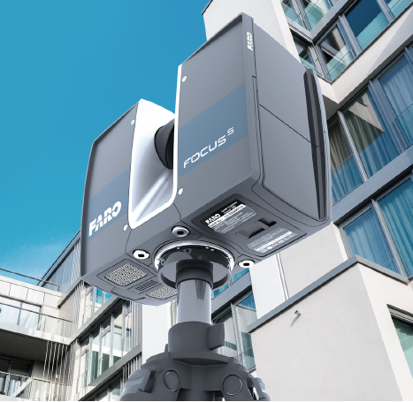
The Faro Focus laser scanner. (Photo: Faro)
The solution further enhances productivity by allowing users to capture complex environments where traditionally would be inaccessible to ground based scanning and levels of accuracy and detail from the air with exceptional.
The data can then download to FARO Zone for crash reconstruction, security pre-planning, military reconnaissance.
The Faro–Stormbee airborne solution has no need for control points, meaning is quicker to start scanning an area compared to other lidar drones. Drone pilots can fly with ease as it goes up to 100 meters (328 feet) in the air. With the drone’s integrated redundancy, even if a propeller or battery fails the UAV still flies.
“Stormbee has developed and validated its UAV credibility from real-life testing in the most rigorous environments,” said Liesbeth Buyck, CEO of Stormbee. “As a result, we are confident that this turnkey solution, that includes the Stormbee UAV and the FARO Focus laser scanner, creates a new reliability and quality benchmark for airborne 3D data capture solutions.”
Users can create centimeter-level accurate point clouds directly from the in-flight data. The user-friendly Beeflex software takes little training to use and can be exported directly into Faro Scene or Faro Zone 3D software for further analysis or to combine aerial scans with the detail-rich data from terrestrial scanners.
The Faro scanner can detach from the drone and be used as a terrestrial scanner or even a mobile mapper. This flexibility allows users to use one scanner in the air, on land or affixed to a vehicle.
Combined with Faro’s Focus laser scanner compact design, IP54 rating and laser technology users can scan a vast variety of scenarios, from large areas (railways, cities), areas with no light (tunnels, burned buildings), and hard-to-document areas (cluttered crime scenes, inside dumpsters).
TDK’s booth at the Consumer Electronics Show (CES) is in South Hall 3, Booth #30306, and offers a look at sensors, passive components and more from TDK and its group companies. (Photo: TDK)
TDK Corporation has launched its InvenSense Coursa Drive software, an inertial-aided positioning solution for autonomous vehicle platform developers.
A high-performance extension of the InvenSense Positioning Library (IPL) that has provided sensor-aided positioning to more than 50 million devices worldwide, Coursa Drive enhances inertial-only vehicle positioning to <0.2 percent of distance traveled. These precise levels of accuracy are critical to maintaining decimeter lane-level vehicle positioning in challenging GNSS/perception system environments.
Coursa Drive’s inertial navigation system (INS) calibrates using absolute position inputs from either high-accuracy GNSS receivers or from perception-based systems (camera, radar, lidar) with high-definition (HD) maps.
In real time, Coursa Drive provides high-rate, 100 Hz delta positions and orientation to the autonomous vehicle (AV) system, complementing the lower-rate position references from GNSS and perception systems.
For improved system fault-tolerance, Coursa Drive can provide decimeter position precision for short periods when the GNSS or perception systems are uncertain or unavailable.
For non-real-time applications such as HD map creation and maintenance, Coursa Drive’s offline mode reprocesses INS data at two to three times higher accuracy than real-time mode, providing HD map companies alternative position references to verify HD map accuracy, even without GNSS, for up to 60 seconds.
“Coursa Drive delivers vehicle dead reckoning accuracy equivalent to high-end systems costing thousands of dollars,” said Mike Housholder, senior director of the TDK InvenSense Location Software and Services Business. “Our cost-effective software solution will help AV platform and Tier 1 vehicle manufacturers scale beyond prototype vehicles to high-volume mass production.”
Coursa Drive provides autonomous vehicle platform developers with maximum flexibility for system integration. The solution is platform agnostic and can operate on Cortex-M4F-class microcontrollers, or higher, and supports most dual-frequency GNSS receivers. The Coursa Drive API specifications are available upon request.
Coursa Drive is thoroughly tested and characterized using the InvenSense line of automotive-grade IMUs, including the IAM-20680 and IAM-20680HP, as well as several industrial grade IMUs. Coursa Drive is available now for select early partners and customers.
TDK and its group companies offering a comprehensive portfolio of sensors, electronic components and solutions for mobile, wearables, AR/VR, automotive, IoT and industrial applications will be at CES 2019, showcasing the Coursa Drive solution, along with additional innovative sensor solutions, in Booth #30306, Las Vegas Convention Center, South Hall 3, Jan. 8-11, Las Vegas.
Main applications
Level 2 to Level 5 advanced driver-assistance systems (ADAS)
Robotaxis
Trucking
Precision agriculture
Key features
World’s first high-precision inertial-aided positioning software for AVs
Inertial-only decimeter precise positions provided during short GNSS or perception system outages/uncertainties
High-rate, 100 Hz position and orientation updates supplied to the AV system
GNSS-agnostic software solution offers flexible integration for full-stack AV solution providers
Unique offline mode further enhances accuracy by two to three times for HD map building and maintenance applications.