The first global GNSS-reflectometry ocean-wind data service has been launched by Surrey Satellite Technology Ltd. (SSTL) with the National Oceanography Centre (NOC), and with support from the European Space Agency.
The online data service, dubbed MERRBYS (Measurement of Earth Reflected Radio-navigation signals By Satellite), is free.
Users can access measurements of wind taken by a specially designed GNSS receiver hosted on SSTL’s TechDemoSat-1 satellite, which collects signals reflected off the surface of the ocean. The service offers monthly maps of wind speed over the oceans.
TechDemoSat-1 is also collecting GNSS reflections off land and polar regions, opening the door for new applications of this technology, such as soil moisture and ice measurements.
TechDemoSat-1 was launched in 2014 and carried eight payloads from different U.K. organizations. On successful completion of the satellite’s original mission, a life extension now allows the GNSS reflectometry payload to be operated continuously.
Onboard processed GNSS-R data is relayed to SSTL’s ground station in the U.K. and inverted for geophysical parameters using NOC retrieval algorithms for the estimation of near-surface ocean wind speed.
Users have access to data from the past three years, and new data is added daily with a latency of 30 days. Users can also register for a fast service allowing retrieval of data with a shorter delay — currently 48 hours, but with a target of less than 24 hours as the service matures.
Pilot demonstration
The current service is a pilot demonstration showing the potential for a new source of wind and wave measurements from in orbit using a small satellite. In the future, a constellation of low-cost small satellites carrying enhanced instruments could provide measurements in near-real time to support weather and wave forecasting.
The TechDemoSat-1 satellite and payload were supported by U.K. Centre for Earth Observation Instrumentation and the U.K. Space Agency, and sponsorship from European Space Agency has allowed the release of data.
More than 50 international journal papers have been published based on the use of the TechDemoSat-1 GNSS-R data. GPS World first discussed the technology in a 1999 Innovation column by GPS World Leadership Award Winner Attila Komjathy, “GPS, a new tool for ocean science.”
SSTL also provided the same GNSS reflectometry instrument to the NASA CYGNSS mission, where eight small satellites are using this technique to probe and analyze hurricanes.
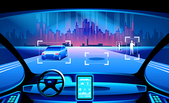
Growing awareness of the vulnerabilities of GNSS signals — weak, unencrypted and easily jammed or spoofed — have made GNSS less important to steering the driverless vehicle. What’s up with that?
Extensive visual map databases are being created that, when coupled with cameras, radars and lidars on the vehicle and processed by artificial intelligence (AI) algorithms, enable the driverless car to be steered much the way humans drive. Pattern recognition processing in the vehicle allows it to “read” street signs and recognize landmarks, registering its position on the map.
This is the way a person drives in his or her home town, where they always know their orientation and don’t need GNSS. The AI processing “brain,” with access to huge map databases, either through local storage or a network connection, will always be in its familiar home environment: continuously knowing its own position and properly oriented for navigation.
So, will GNSS become unnecessary in the car of the future? Probably not.
First, no one method of navigation is foolproof, and today, GNSS is our primary method of navigating our cars. It is a cost-effective, accurate way of determining position in real time, and with the integration of inertial navigation sensors to handle cases when GNSS is intermittently unavailable, it is improving.
Second, it is not just the car itself that needs to know its location for navigation, but also others outside the car. Ride-sharing apps like Uber and Lyft, car-sharing, usage-based insurance apps, dynamic toll charging, and parking apps all depend on knowing where the car is at all times. GNSS offers sufficient accuracy for all these apps by providing location coordinates. Therefore, a GNSS receiver will most likely remain in the car.
The case for jamming and spoofing
Recall, however, that one of the weaknesses of GNSS is its open, unencrypted format. It is becoming increasingly easier to spoof these signals. Car-sharing, usage-based insurance and dynamic toll charging apps all create a monetary incentive for fraud that can be implemented with a spoofer. For example, a car in a car-sharing network can report a fake position indicating that it is safely parked in a secure area — while in reality, a thief is busy driving it away.
(Image: Orolia)
Let’s assume that all wireless connections to and from the car are secure. This is a reasonable assumption, although recently there have been demonstrations of carjacking via unsecure remote links. Standard SSL encryption, similar to what is used to enter credit card information on the internet, works well here. We have both the awareness and the technology now to prevent such carjackings from ever reoccurring.
However, even if communication links are secure, a GNSS spoofer in the car can fool the GNSS receiver into reporting a fake “safe” position right as it is being stolen. The same is true for insurance or toll apps. And the fraud does not have to be sophisticated. A simple, low-cost jammer can deny proper position just long enough to skirt payment. A secure location method is needed.
Other signals for localization
What would an ideal signal for localizing a driverless car look like?
It needs to be much stronger than GNSS so it is not easily jammed.
It needs to be encrypted so it cannot be spoofed.
It must be ubiquitous, available worldwide.
It must be reliable and robust — with 99.999% availability or better.
It must be practical and priced for the mass-market automotive application.
Though accuracy is always important, the signal used for localization does not have to be as accurate as GNSS is today. Accuracy to 10s of meters is sufficient for all these applications needing fraud protection since it would not be used for steering the car, but rather, only localization. It can also be used in tandem with GNSS to authenticate a reported position when a GNSS signal is available.
Such a signal is available today, worldwide: STL (Satellite Time and Location). Carried on the Iridium satellites, it is a special purpose signal that is more than 30 dB stronger than GNSS and encrypted for anti-spoof protection. Decoding of this signal is available via a subscription model to users.
Here’s how it would work using a car-sharing example. A group of people subscribe to a car-sharing service that provides X number of cars to serve Y number of people, where X is less than Y. The service optimally schedules people when and where a car will be available. The service provider needs to know the whereabouts of the cars at all times to maximize utilization of the fleet, so every car has a GNSS receiver in it.
But to ensure the authenticity of these reports, they also have a secure localization receiver. This receiver is assigned a unique ID that is authorized to decode the encrypted signal. (Eventually, we expect this receiver and GNSS to converge into one device much the way multi-GNSS receivers operate today).
If a position report does not agree with the authentic localization report, the fleet manager can act to recover the car immediately. Insurance providers who cover secure localization-equipped cars would also give preferential rates as an anti-theft device.
(Image: Pavel Vinnik/Shutterstock.com)
Could PRS do it?
The new Public Regulated Service (PRS) from Galileo is encrypted and could provide a similar level of authentication protection, if made available. However, it is still a weak GNSS signal that can easily be jammed. Of course, any signal can be jammed, even one that is a thousand times stronger than GNSS.
However, given the robust nature of a very strong signal, the managing system that is monitoring the cars — the insurance, toll or car-sharing system, for example — can alarm upon the loss of positioning information. Such alarms on a GNSS-only car would be frequent and often erroneous due to simple fades, yielding so many false alarms that it would render the monitoring system useless. But a loss of both the strong localization signal and GNSS would likely be considered suspicious and result in a valid alarm.
GNSS navigation is truly one of the great advances of the modern era, giving us precise time and location for any place in the world. Its two major weaknesses — that it is easy to jam and spoof — can be overcome by augmenting it with other stronger encrypted signals, such as STL, providing robust jam-resistance and positive authentication.
The airport’s new autonomous ATV begins testing in August. (Photo: Edmonton International Airport)
An autonomous all-terrain vehicle (ATV) equipped with NovAtel Inc. technology will soon join the security fleet at the Edmonton International Airport in Alberta, Canada.
The ATV will be used to detect people and animals that breach the airport perimeter, as well as locate holes in the fence to alert the security team.
This is the only known autonomous ATV to be used for airport security and it will be used to monitor its 20-kilometer fence line on a narrow perimeter road, according to Hexagon, NovAtel’s parent company.
The unarmed vehicle is controlled remotely by humans and can also drive autonomously, incorporating machine-learning to perform its tasks.
The vehicle system includes navigation, path planning, obstacle avoidance, animal and human recognition, communication systems to airport security, geo-fencing, and situational awareness and analysis.
The autonomous ATV patrols will focus on the following:
Identifying damage to the chain-link fence and fence posts, verifying barbed wire is taut and undamaged, and detecting holes or gaps under the fence
Detecting human or animal activity
Searching for obstacles using lidar
“We would not have been able to navigate the vehicle on such a narrow road if we had not used NovAtel gear,” said Ken Brizel, CEO, ACAMP.
The autonomous security ATV was developed by the Alberta Centre for Advanced MNT (microprocessor and nanotechnology) Products (ACAMP).
The airport is a member of the Advanced Systems for Transportation Consortium established by ACAMP and supported by the Government of Alberta. ACAMP is a member of the Alberta Aerospace and Technology Centre at EIA. ACAMP and EIA were able to harness technologies developed by consortium members to construct and test the autonomous ATV security vehicle, readying it for regular use at EIA.
A LinkedIn post from the company suggests theater-goers “Keep an eye on the scene where Tom Cruise flies a helicopter through a narrow canyon to catch our Compact GNSS Antenna in action!”
Above is a behind-the-scenes video that shows how Airbus helped Cruise, an actor known for doing many of his own stunts, learn to fly a helicopter and navigate a treacherous dive sequence (with the aid of the NovAtel receiver).
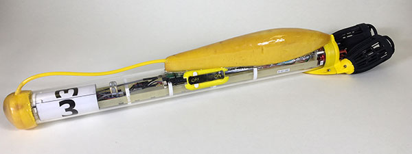
SwarmDivers by Aquabotix are micro swarming unmanned surface vehicles (USVs) capable of diving to 50 meters and swarming in groups of 40 or more.
Multiple SwarmDivers can function simultaneously as a single coordinated entity, be easily controlled via one operator on the surface and perform dives on command to collect valuable intelligence.
Their design delivers rugged reliability and accuracy for applications requiring specialized sensor payloads in defense, oceanography, aquaculture, research and hydrographic survey, the company said. The units also operate collectively to quickly gather data and report back in near real time.
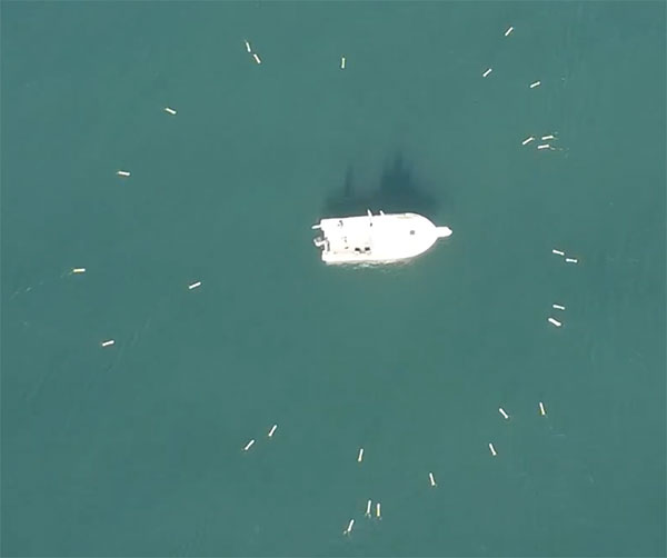
This screenshot from an Aquabotix video shows the swarm returning to base. (Image: Aquabotix)
The swarming algorithm allows vehicles to communicate with each other to make decisions as a group. This allows SwarmDiver to quickly and accurately self-arrange in various swarm formations as well as dive simultaneously to collect synoptic data sets.
With the ability to be outfitted with customized payloads and sensors, SwarmDiver can meet a wide range of mission profiles, Aquabotix said.
For the defense community, SwarmDiver could provide surf-break-zone operations support, enhanced navigational capabilities, explosive ordnance disposal and mine countermeasures.
A FreeFlight Systems SBAS/GNSS receiver has been selected to provide ADS-B position source information as a part of an upcoming ADS-B modification and compliance program for the United States Air Force HH-60G helicopter fleet.
Strategic Enterprise Solutions Corp. (SESC) of Warner Robins, Georgia, was awarded the modification program, which includes installation of the 1203C SBAS/GNSS receiver and the AN/APX-119 Mode S Extended Squitter transponder with Mode 5 capability to provide a complete ADS-B Out solution for more than 100 helicopters.
An HH-60 Pave Hawk helicopter lands in Afghanistan; a UH-60 Blackhawk is in the background. (Photo: U.S. Air Force photo/Senior Airman Brian Ferguson)
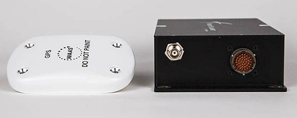
The FreeFlight Systems 1203C SBAS/GNSS receiver is a certified, high-integrity position source in a compact, lightweight package that was designed to be modular and able to be integrated with various other avionics.
The 1203C pairs seamlessly with certified Mode S Extended Squitter transponders for a fully rule-compliant ADS-B Out system, FreeFlight said.
More than a war hawk. The primary mission of the HH-60G Pave Hawk helicopter is to conduct day or night personnel recovery operations into hostile environments to recover isolated personnel during war.
The HH-60G is also tasked to perform military operations other than war, including civil search and rescue, medical evacuation, disaster response, humanitarian assistance, security cooperation/aviation advisory, NASA space flight support, and rescue command and control.
The 1203C in service. With several hundred 1203Cs in service across airline transport, military, business aviation and rotorcraft platforms, these receivers are known for their high performance, ease of installation, operational reliability and longevity, FreeFlight said.
The 1203C SBAS/GNSS receiver and antenna (Photo: FreeFlight Systems)
The 1203C can also serve as the approved position source for select manufacturers of TAWS/FMS, RNP and other NextGen applications, and allows customers to take advantage of the operational and safety benefits provided by the NextGen airspace transformation without the need for extensive and costly avionics upgrades.
With the ADS-B mandate now only 17 months away, aircraft operators need to prioritize ADS-B installations.
Significant portions of today’s airline, business, and military aircraft fleet will remain in service long after 2020, and in many cases an STC’d retrofit solution comprising of a transponder upgrade and the addition of a dedicated SBAS/GNSS receiver like the 1203C is the simplest and most cost-effective way to achieve mandate compliance, FreeFlight said.
NXP Semiconductors N.V. has announced the next phase in its Smart City collaboration with Columbus, Ohio, the winner of the 2016 U.S. Department of Transportation’s $40 million Smart City Challenge.
NXP will contribute key technologies for smart and safe mobility to the Smart Columbus Experience Center.
Smart Center. On June 30, the City of Columbus celebrated the opening of its Smart Columbus Experience Center. The center allows visitors to see how new mobility options, such as connected, autonomous, shared and electric vehicles, will help make Columbus a more connected community.
Hands-on educational experiences and technology demonstrations aim to show visitors how technology and innovation in transportation can grow the local economy and create ladders of opportunity for central Ohio residents.
Visitors to the Smart Columbus Experience Center will learn how Vehicle to Everything (V2X) Technology allows cars to communicate with each other as well as with intelligent traffic infrastructure to keep mobility safe and efficient. (Image: NXP USA)
Cohda Wireless. As part of the Smart Columbus Experience Center initiative, NXP and Cohda Wireless will deploy a connected vehicle environment through the center’s electric vehicle test drive area so drivers can experience this future technology in person.
NXP has also donated an electric motorcycle with an accompanying drone that alerts the driver to dangers or delays ahead.
Key smart city technologies
As part of its commitment to Columbus, NXP will continue to contribute key mobility technologies to the Smart Columbus Experience Center, including:
NXP’s RoadLINK V2X technology allows cars to communicate with each other as well as with intelligent traffic infrastructures. The IEEE802.11p Dedicated Short Range Communications (DSRC) standard allows cars to securely connect to each other as well as to infrastructure. DSRC technology is the only ADAS sensor that can look around the corner and offers lowest latency in the communication.
Smart Card IC technology that enhances transportation for all citizens by supporting secure and convenient public transportation ticketing and payment systems, including contactless transit fare solutions.
Highly secure NXP Radio Frequency Identification (RFID) solutions designed to promote public safety and convenience. Smart City applications for this NXP technology include vehicle window stickers that enhance driver convenience and reduce municipal costs by eliminating the need for stop-and-pay stations in public parking spaces.
NXP eBike and Drone demo at the new Smart Columbus Experience Center shows how drones could send real-time video of a traffic incident to a city emergency vehicle. (Image: NXP USA)
Concept of Operations released
Smart Columbus, the smart city initiative from the City of Columbus, in July released the Concept of Operations for its Connected Vehicle Environment (CVE) pilot.
The Concept of Operations outlines in detail how the CVE pilot will be implemented over the next two years. The pilot will involve:
113 road side units (RSUs) that will be installed at intersections with stoplights
up to 1,800 on-board units (OBUs) that will be installed on participating private, emergency transit and freight vehicles, and
12 vehicle-to-vehicle or vehicle-to-infrastructure applications that will be deployed, according to the document.
Goals of the CVE pilot include improvements of:
vehicle operator safety
intersection safety
school zone safety
reliability of transit vehicle schedule adherence
emergency vehicle response times
traffic management capabilities.
Smart city demonstrations. Visitors to the Smart Columbus Experience Center can try out electric automobiles. A fleet of six electric vehicles will be on display and is available for test drives through a connected vehicle environment provided by NXP and Cohda Wireless.
Vehicles on display or available for test drives include:
a BMW i3 provided by BMW
a Chevrolet Bolt provided by Dave Gill Chevrolet
a Honda Clarity provided by Honda
a Mercedes-Benz GLE 55e provided by Daimler
a Nissan LEAF provided by Nissan North America
a Toyota Prius Prime provided by Toyota.
An electric motorcycle provided by NXP and a Ford Ojo electric scooter are also on display.
The National Space-Based Positioning, Navigation, and Timing Advisory Board (PNT Board) will take part in a public teleconference on spectrum issues on Aug. 6.
The meeting will be held via teleconference and WebEx. The teleconference will take place Monday, August 6, from, 12-4 p.m. Eastern Time.
This meeting will be open to the public telephonically and by WebEx. Any interested person can call the toll-free (in the U.S.) conference-call number at 1–844–467–4685 or the local toll number at 1–720–259–7012 using passcode: 106724 to participate in the meeting by telephone.
The WebEx link is https://nasa.webex.com/, the meeting number is 995 034 805, and the password is uuU7bDX* (case sensitive).
This meeting was agreed to at the 21st session of the National Space-Based PNT Advisory Board, held May 16–17 in Baltimore. The public can follow the discussions by dial-in or the web link provided.
The agenda includes the following topics:
Finalize and approve the National Space-Based PNT Advisory Board topics paper
Finalize and approve the National Space-Based PNT Advisory Board Memorandum on Spectrum Issues to the National Space-Based PNT Executive Committee, Carol J. Hamilton, acting advisory committee management officer, NASA.
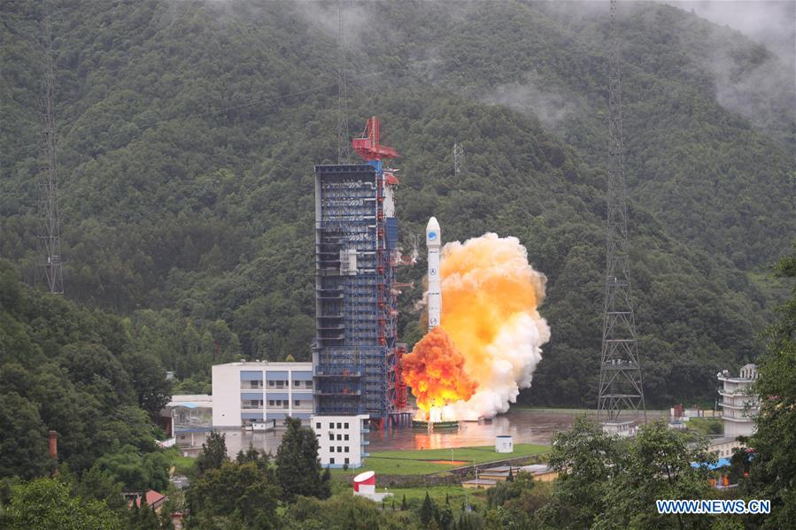
China has launched another pair of BeiDou-3 navigation satellites, reports Xinhua News Agency, China’s state-run press agency.
A Long March-3B carrier rocket lifted off from Xichang Satellite Launch Center in southwest China’s Sichuan Province on July 29.
The twin satellites are the 33rd and 34th of the BeiDou navigation system. They entered orbit more than three hours after the launch. After a series of tests, they will work together with eight BeiDou-3 satellites already in orbit, said the launch service provider.
A basic system with 18 BeiDou-3 satellites orbiting will be in place by the end of 2018, and will serve countries participating in the China-proposed Belt and Road Initiative.
Named after the Chinese term for the Big Dipper, the BeiDou system started serving China in 2000 and the Asia-Pacific region in 2012. It will the fourth global satellite navigation system after the U.S. GPS system, Russia’s GLONASS and the European Union’s Galileo.
The satellites and the rocket for Sunday’s launch were developed by the China Academy of Space Technology and China Academy of Launch Vehicle Technology, respectively. This was the 281st mission of the Long March rocket series.
China sends the 33rd and 34th BeiDou satellites into space on July 29. (Photo: Xinhua/Liang Keyan)
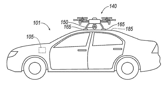
Ford has applied for a patent that would send a drone to dock with an autonomous vehicle and act as a surrogate sensor if one of the car’s sensors failed. The UAV then uses its own sensors to guide the car to a repair facility.
A UAV docks with a car. (Diagram: Ford’s patent application)
The filing from Ford Global Technologies, a subsidiary that manages and commercializes patents and copyrights, outlines the process.
Once the vehicle registers a fault in one of its sensors, it uses a vehicle-to-vehicle (V2V) network to summon the drone, which flies to the vehicle, receives authorization, and then lands atop it. The UAV then serves as a replacement sensor while directing the vehicle to a nearby repair center to fix the car’s sensor.
Ford developed the technology to aid autonomous vehicles that have lost a critical navigation sensor; autonomous cars use GNSS, short- and long-range radar, lidar, cameras and ultrasound.
The European Space Agency launched the next four Galileo satellites on an Ariane 5 on Wednesday July 25, at 11:25 GMT (13:25 CEST, 08:25 local time) from Europe’s Spaceport in Kourou, French Guiana.
These latest four Galileo satellites will bring the constellation in orbit up to 26 satellites.
Livestream coverage of the launch starts at 11:00 GMT (13:00 CEST) with liftoff at 11:25 GMT (13:25 CEST).
Live coverage resumes with confirmation of the satellites separating from their upper stage from 14:50 GMT (16:50 CEST).
Separation of the Ariane 5’s upper stage occurs about nine minutes after liftoff, followed by the first 10-minute firing of the upper stage.
The upper stage — carrying four 715-kg Galileo satellites — flies in ballistic configuration for three hours and eight minutes, after which a second upper stage firing lasting just over six minutes will place it into circular separation orbit.
Once stabilized at 3h 36 min after liftoff, the Galileo dispenser will release the first two satellites, followed by the second pair 20 minutes later.
In the meantime, check out ESA’s new Galileo video.
The Ariane 5 carrying Galileo satellites 23-26 is in place at the ZL3 launch site ready for liftoff. (Photo: ESA)
Ligado’s proposed broadband service continues to pose a significant risk of harmful interference to GPS, several key signatories wrote in a July 18 letter to U.S. Federal Communications Commission (FCC) Chairman Ajit Pai.
The interference would occur despite Ligado’s May 31 amendments to its license modification applications, the letter states. “The proposed Ligado operations, even after the recently proposed amendments, will harmfully impact a wide range of GPS receivers and thus should not be permitted.”
Key signatories include representatives of Iridium Communications, the International Air Transport Association, Lockheed Martin, Rockwell Collins and Satelles.
The letter urges the FCC to deny Ligado’s pending license modification application unless Ligado can show it has addressed the substantive GPS interference concerns. Also encompassed in the letter are concerns over interference with satellite communications (SATCOM) and weather data.
“The record, augmented by recent government reports, makes clear that the interference will be particularly impactful to the countless government and commercial entities that rely on GPS and SATCOM services for aviation safety and other critical services,” the signatories wrote.
“A number of data points underscore the flaws in the way in which Ligado has attempted to measure interference to GPS from its proposed terrestrial operations.”
Ligado recently acknowledged that its license modification request as originally filed is insufficient to protect certified aviation GPS receivers, but offered no changes to its proposal to address interference to uncertified GPS systems, SATCOM services (also important for aviation safety), or concerns of the weather data community.
“Evaluating Ligado’s recent amendment to ensure protection of uncertified GPS receivers and protection of GPS receivers from aggregate interference will be necessary,” the letter states.
1-dB Criterion. One issue is the 1-dB degradation interference protection criterion, which Ligado has suggested is “neither accurate nor reliable.” That criterion was used in the U.S. Department of Transportation’s Adjacent Band Compatibility assessment issued in April, which examined the maximum transmitted power levels of adjacent band systems that can be tolerated by GPS receivers. The study endorsed and strictly applied the 1-dB criterion, and termed it the “accepted, worldwide standard for PNT and many other radio communication applications.”
“Each of these government efforts supports one conclusion — the proposed Ligado operations, even after the recently proposed amendments, will harmfully impact a wide range of GPS receivers and thus should not be permitted…
“We urge the Commission to deny Ligado’s pending license modification application as proposed unless Ligado can show it has addressed the substantive GPS, aviation, SATCOM, and weather data interference concerns still outstanding in the record,” the letter concludes.