Author: Tracy Cozzens

  • How to achieve 1-meter accuracy in Android

    How to achieve 1-meter accuracy in Android

    Recent changes in hardware and standards make one-meter accuracy possible, in some cases as soon as this year. The transcript of a talk given to Android developers earlier this year, this article gives a short overview of location in smartphones, introduces Wi-Fi round-trip time technology and standards, and then explains the Wi-Fi application programming interfaces.

    By Frank van Diggelen, Roy Want and Wei Wang, Android Location, Google

    Image: GPS World; outdoor, Andriy Solovyov/Shutterstock.com; indoor, Rade Kovac/Shutterstock.com
    Image: GPS World; outdoor, Andriy Solovyov/Shutterstock.com; indoor, Rade Kovac/Shutterstock.com

    It’s a great time for location applications because technology hardware standards and Android application programming interfaces (APIs) are all evolving simultaneously to enable an improved location accuracy that has not previously been possible when using smartphones.

    Eventually, this means high accuracy for everyone, but we want to take you under the hood of location because we want to give you the opportunity to get a head start on the future. We also want to highlight the need to protect and respect the user. The more people who use location, the more careful we and you have to be. We will highlight where you must get user permissions and we’ll close with some guidelines for making great location apps.

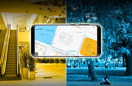
    Where are we today with indoor location accuracy? If you’ve noticed that your phone seems to be more accurate when you’re inside shopping malls and office blocks than it was a few years ago, you’re not imagining it. With each release of the fused location provider, we have had steady improvement of the Android algorithms and machine learning for Wi-Fi locations.

    There continues to be improvement, and you’ll see indoor accuracy of better than 10 meters, but round-trip time (RTT) is the technology that will take us to the one-meter level.

    Meanwhile, what about GPS? In terms of GPS accuracy in the open sky, there has not been much change in the last few years. If you’re outside and can see the open sky, the GPS accuracy from your phone is about five meters, and that’s been constant for a while. But with raw GNSS measurements from the phones, this can now improve, and with changes in satellite and receiver hardware, the improvements can be dramatic.

    Everyone’s familiar with the blue dot, but to get the blue dot you need a location provider, and to get location you need measurements — specifically, range measurements from Wi-Fi access points or from GPS satellites. We’ll show you how one-meter measurement accuracy can be made available in smartphones. The key technologies are Wi-Fi RTT, GPS dual-frequency and carrier phase measurements.

    If you want to wait a year or two, this will find its way into the worldwide ecosystem and the Android fused location provider API, but we want to give you a chance for a one- to two-year lead by taking accurate measurements and turning them into accurate location. We want to work with you to accelerate development and bring the present closer to the future.

    You might wonder, why do I need better location accuracy anyway? Let’s look at two instances where existing apps could use much better location accuracy.

    For indoor routing or navigation of the kind that you’re used to in your cars, you need much better accuracy than you have outdoors: you need one-meter accuracy, because indoor features like cubes or aisles are only a few meters wide. Even for the most loved outdoor applications such as map directions and finding alternate routes in traffic, we could benefit from higher accuracy than we have now.

    For example, when you came here this morning in a car, you probably had your arrival time estimated using the average speed of the traffic. What you really want is the traffic speed in the lane that you’re in, so that you could ask, how much faster would it be if I took the carpool lane instead? There are, of course, many other use cases and we’ll mention a few. But the important thing is that we are sure that you will have many more ideas than we have, and that’s the beauty of the open Android ecosystem.

    Wi-Fi Round-Trip Time

    Wi-Fi RTT ranging and indoor position estimation is based on making measurements of the time of flight of RF signals, and can be used to estimate your indoor position to an accuracy of one to two meters.

    Before we get into the details of Wi-Fi RTT, we want to tell you how we currently calculate an indoor location. At this time, we use Wi-Fi received signal strength indication (RSSI). Basically, we can calculate distance as a function of signal strength. Figure 1, with the access point in the center, shows a heat map of the signal strength around a Wi-Fi access point (AP).

    Figure 1.  Wi-Fi receive signal strength indication (RSSI) non-isotropic signal propagation. (Image: Frank van Diggelen, Roy Want and Wei Wang)
    Figure 2. Wi-Fi RTT principles, basic concept. (Image: authors)
    Figure 2. Wi-Fi RTT principles, basic concept.(Image: Frank van Diggelen, Roy Want and Wei Wang)
    Figure 3. Wi-Fi RTT principles in practice. (Image: authors)
    Figure 3. Wi-Fi RTT principles in practice. (Image: authors)

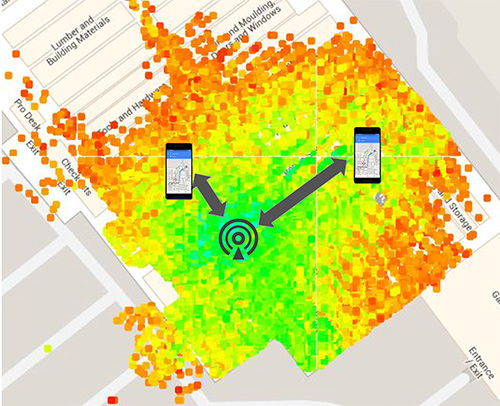
    The green is the strongest signal, near the AP and the red is the weakest, measured toward the edges. I’ve placed two phones on this diagram at the transition between the weak and the strong. Notice that the phone on the right is further away from the access point than the phone on the left. The signal strength can therefore vary at the same distance, which unfortunately makes it very hard to make accurate range measurements based on this type of measurement. There are lots of algorithms and tricks that can be used to improve this, but the greatest improvement can be achieved using a new Wi-Fi technology.

    That’s where Wi-Fi RTT comes into play. It uses time-of-flight instead of signal strength. It measures the time it takes to send a Wi-Fi RF packet from an access point to a phone and back again. Because radio signals travel at the same speed as visible light, if we multiply the total round-trip time of a Wi-Fi packet by the speed of light and divide by two, we get distance, and therefore the range from the phone to the access point. That’s the basic principle.

    If you want to use several ranges to nearby access points to calculate your position, we have to use a process called multi-lateration. The key thing to think about here is that the more ranges you have, the more accurate the position you can estimate. If you can use at least four ranges, then we think you can achieve a location accuracy of about one to two meters in most buildings.

    Why are we telling you about Wi-Fi RTT today? Why not last year or before? Because 2018 is the year of Wi-Fi RTT in Android. We are releasing a public API in Android P based on the IEEE 802.11mc ranging protocol. Furthermore, we’re also integrating aspects of this protocol into the fused location provider, which is the main location API that developers use to put a blue dot on a map. So, in the near future, any time there are RTT access points in the vicinity of a phone, the estimated position accuracy will be greater.

    History. The 802.11 standard was ratified in December 2016, and in early 2017 the Wi-Fi Alliance started an interop program for silicon vendors to make sure the chips followed the protocol. That’s when we started doing a lot of work to validate its operation and understand how it could be integrated into Android. By the fall of this year, we will release the public API so that you can all have access to this capability and can build your own applications around the technology.

    Principles of Wi-Fi RTT Operation

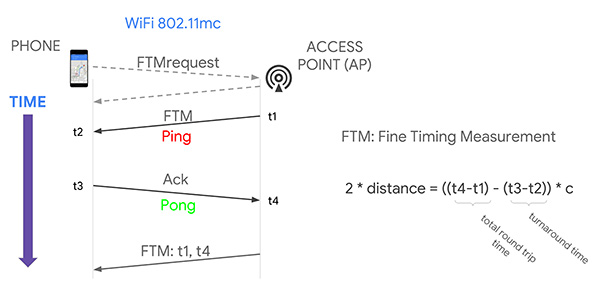
    The ranging process starts with a standard Wi-Fi scan. The phone discovers the access points that are nearby, and, based on certain bits in information elements (IEs) contained in the Wi-Fi beacons and the probe responses, we can figure out which of those access points are RTT-capable, and the phone can choose one of them to range to. It starts by making a request to the access point; as a result, the access point will start a ping-pong protocol in response. The ping sent to the phone is called a fine timing measurement (FTM) packet, and the pong sent back to the access point is an acknowledgment of that packet.

    The arrival and departure time stamps are recorded at each end of the transaction, but for the phone to calculate the total round-trip time, it needs to have all four of those times. So the access point sends one more packet to the phone, and this third message contains the missing times. The phone then simply calculates the round-trip time by subtracting the time stamps from the AP, and subtracting its own packet turnaround timestamps. The difference between these times leaves just the packet time-of-flight. We multiply this by the speed of light to get distance, and divide by two to get the range that we are trying to measure.

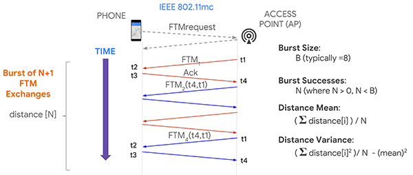
    Now, it turns out if you execute this process multiple times, you will in fact get more accuracy, and so that’s what the protocol allows for, enabling a burst of FTM packets. We’re typically doing a burst of about eight of these of these transactions and, as a consequence, the system can calculate ranging statistics, such as the mean and the variance. This allows us to more accurately plot a position on a map, and knowing the accuracy also allows us to more easily calculate a trajectory.

    Now that you have ranges, how do you get a position? One way, similar to GPS positioning, is you take four ranges to four separate access points; if those ranges were accurate, they would define four circles that would intersect at a single point. In practice, because of error in each range, a maximum likelihood position is calculated using a least squares multilateration algorithm.

    You can then further refine this position by repeating the process, particularly as the phone moves, and then calculate trajectory using filtering techniques, such as Kalman filtering, to optimize the estimate.

    Like any new technology, there are challenges, and we’ve experienced some of these early on. What we find is that sometimes there is a constant range calibration offset that may be as much as half a meter. Sometimes you also see multipath effects where a packet on the non-line-of-sight path from the access point to the phone is received rather than on the line-of-sight path, making the range appear longer. That problem can be solved by the vendor using something called antenna diversity, but all of these issues are related to algorithms, which the vendors are improving.

    Basically, we need to go through a sort of teething process to get rid of these bugs, and Google can help in this process by providing reference platforms and reference applications. Vendors can then calibrate their own platforms before you guys even get to use them, which will be the ideal situation.

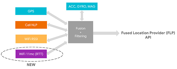
    We’ve assumed that as early adopters you want to start using this API, but as we move into the relatively near future, we expect you to just use the Fused Location Provider because we’re going to be integrating the RTT capability into it. At the moment, the Fused Location Provider uses GPS (when it’s available), cell-tower signal strength and Wi-Fi RSSI, and fuses all this with the onboard sensors: inertial navigation from the accelerometer, gyro and compass. Now we’re adding Wi-Fi RTT into that mix, and it will increase the accuracy of the Fused Location Provider whenever RTT-capable access points are available nearby.

    One other thing to remember is that if you are calculating the Wi-Fi RTT position yourself, you also had to know the position of the access points. In the Fused Location Provider, we will calculate those positions for you automatically: we’ll crowd-source those positions so you won’t have to worry about that, and it will make life a lot easier for you to write applications.

    RTT APIs

    Let’s walk you through the RTT APIs in P to see how you can add RTT in your own application. As we mentioned, RTT measures the round-trip time between two Wi-Fi devices so both your mobile phone and your access points need to support the 802.11mc protocol. As you saw, RTT can give you very fine location estimates down to one-meter accuracy, so your application needs to declare the ACCESS_FINE_LOCATION permission. Of course, both location and Wi-Fi scanning need to be enabled on the mobile device.

    How do you know whether your mobile phone supports RTT? In P, we added a new system feature called FEATURE_WIFI_RTT so you can simply check whether this returns true on your mobile device. Our pixel phones running P DP2, and above, will support RTT. How do you know whether your access points support RTT? As usual, you will need to do a Wi-Fi scan and get a list of Wi-Fi scan results. Then iterate through the scan results and check for each scan result whether the method is80211mcRepsonder() returns true. This will tell you whether the access points support RTT.

    After you get a list of RTT-enabled APs, simply add them to the ScanRequest Builder to build a scan request. RTT is carried out by the WiFiRTTManager, which you can get access to by getting the system service WIFI_RTT_RANGING_SERVICE. Now we’re ready to start RTT ranging by sending the RTT request to the RTTManager with a ranging result callback. Usually RTT takes only a few hundreds of milliseconds, and when it finishes, you will get a list of information including the status — an RTT may fail, the MAC address — which AP you have just ranged, and most importantly, the distance between the mobile phone and the access point.

    Here is the list of information you can get from RTT ranging results: the distance, the distance standard deviation, which is the standard deviation from multiple ranges in multiple FTMs, and the number of attempted FTM measurements and number of successful measurements. The ratio of successful measurements over attempted measurements will give you an idea of how good the Wi-Fi environment is for RTT ranging.

    We mentioned all Pixel devices support RTT. How about access points? We are beginning to see access points supporting the 11mc protocol in production. We are also very excited to let you know Google Wi-Fi will soon support the 11mc protocol. By the end of this year, off-the-shelf Google Wi-Fi will have RTT enabled by default. Worldwide, we’re also beginning to see the deployment of RTT APs. South Korea is actually leading the deployment of RTT APs.
    Of course, this is just the beginning of the long journey. We’re very eager to see a larger penetration rate of RTT APs in the coming years.

    Figure 4. Integrating RTT with Android location. (Image: authors)
    Figure 4. Integrating RTT with Android location.(Image: Frank van Diggelen, Roy Want and Wei Wang)

    GPS and the Great Outdoors

    Carrier-phase precision has been in commercial GPS receivers since the 1980s. What is new is the availability of these carrier-phase measurements from phones and dual-frequency measurements in phones. Right now, all of your smart phones, all smart phones everywhere, have GPS or GNSS on one frequency band only. It’s known as L1. But there’s a new frequency in town called L5, and it’s supported by all these GNSS systems: GPS, Galileo, BeiDou QZSS and IRNSS. The availability of a second frequency means that you get much faster convergence to carrier-phase accuracy.

    What about hardware? In the last few months, several companies that produce consumer GPS chips have announced the availability of dual-frequency L1/L5 GPS chips both for the automobile market and for the phone market. These chips are now being designed into cars and phones.

    Let’s talk about the measurements themselves and the APIs. The phone must support the GNSS measurements API. Your app is going to need the ACCESS_FINE_LOCATION permission, and location needs to be on.

    How do you know if a particular phone supports these measurements? At a high level, you can just go to a website that we maintain, g.co/GNSSTools, as part of the Android developer site. A table there lists phones that support the GNSS measurements and also which characteristics they support. It’ll tell you which phones support the measurements and which of those support the carrier-phase measurements.

    Programmatically, you do this as follows: You call the method onStatusChanged and it will return an integer that tells you the capability of the phone, either if the phone just does not support the measurements at all or if it supports it but location is off, or if it supports it and location is on; in that case, you’re good to go.

    Let’s get into some details of the APIs. The most relevant methods for what we’re talking about here are the following three:

    • getConstellationType() tells you which of the different GNSS constellations a particular satellite belongs to.
    • getCarrierFrequencyHz() tells you whether you’re on the L1 or the L5 band for a particular signal.

    Most importantly,

    • getAccumulatedDeltaRangeMeters() tells how far along that carrier wave the receiver has tracked you since it began tracking the signal.

    There’s something else that we need to explain, which is duty cycling. Right now when you’re navigating with your phone and you see the blue dot moving along, you might think that the GPS is on continuously. It’s actually not. What’s happening in the phone is that GPS will, by default, be on for a fraction of a second and then off for the remaining fraction of a second, and then repeat. This is to save battery. You perceive that the GPS is on all the time because the blue dot will move along continually, but actually it’s duty cycling internally.

    For this carrier-phase processing, you have to continually track the carrier wave because the carrier wave is like a finely graduated ruler or tape measure with no numbers on it. So if the GPS was on and your receiver measured your phase and you get the data from the reference station, you’d start processing. If the GPS then goes off for a fraction of a second, you’ve lost where you were. It’ll start again, you’ll reacquire, you’ll be at a different phase on the reacquisition, you’ll start again — well, you’ll never solve the problem. You need the tape measure to stay out and you need to process, and to do that you need to disable duty cycling. You can do that in Android P with a developer option.

    Details of the API. Figures 5 and 6 are screenshots of an application that we’ve put out called GNSS Logger. This enables you to log the raw measurements in the phone. The nice thing about this app is it’s a reference app: the code is open source and available to you on Github, so when you build your app, please make use of our code.

    Figure 5. Screenshot of GNSS Logger. (Image: authors)
    Figure 5. Screenshot of GNSS Logger. (Image: Frank van Diggelen, Roy Want and Wei Wang)
    Figure 6. Sample code for getting GNSS raw measurements. (Image: authors)
    Figure 6. Sample code for getting GNSS raw measurements. (Image: Frank van Diggelen, Roy Want and Wei Wang)

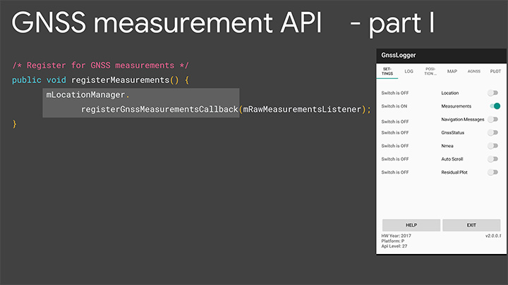
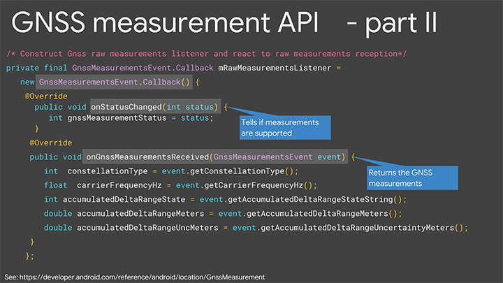
    When you build an app that needs raw measurement, you will need the Android location manager API with the method registerGnssMeasurementsCallback. This method requires you to pass it a GnssMeasurementsEvent callback shown here. You construct this callback, and then override the method onStatusChanged, and that will give you the integer status that we discussed to tell you if measurements are supported.

    If they are, you then override the method onGnssMeasurements Received, and this allows you to receive a GnssMeasurementEvent every epoch, for example, every second. This event gives you the values we’ve been talking about: constellation type, carrier frequency and accumulated Delta range. For duty cycling, that’s a developer option, so you access that through the developer page on your phone as you see there on P. This allows you to disable the duty cycling.

    Keep in mind this introduces a trade-off between getting the continuous measurements and battery life. There will be an impact on battery life. How much? Well even when GPS is on continually, it will use less than 20% of the power that screen-on uses, so that gives you a feel for the magnitude. This is a developer option precisely because it’s a trade-off involving battery life, and we’re very concerned about maximizing battery life, but if you and our team together can prove that there’s value in this option and people want it, then it will be upgraded to a fully supported API in the future.

    Figure 7 shows the basic architecture that we expect if you implement an app for high accuracy. On the bottom of the block diagram on the left you’ve got the GPS/GNSS chip. The GNSS measurements come up through the APIs we’ve just described, and then your app lives at the top in the application layer. You’re going to need access to a reference network to get the data that the reference stations are tracking. There are publicly available reference networks. I’ve listed one at the bottom: the International GNSS Service. You can get data from them free.

    Figure 7. Apps for high-accuracy GPS. (Image: authors)
    Figure 7. Apps for high-accuracy GPS.(Image: Frank van Diggelen, Roy Want and Wei Wang)

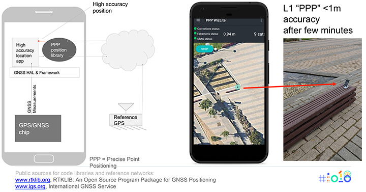
    Then you need to process that data in some kind of position library, and that does all the carrier-phase processing, and that too is available as open-source code. RTKLib.com has an open-source package for precise positioning. Then you’re good to go.

    We mentioned that dual frequency gives you much faster convergence to the high accuracy, but you don’t have to wait until the dual-frequency phones come out. You can start doing this with single-frequency phones. Here’s an example of someone who’s already done that. This is an app created by the French Space Agency, and they’re doing exactly what we show on the block diagram on the left and they’re achieving sub-meter accuracy after a few minutes of convergence.

    Here’s some more external analysis that’s been done in a similar way. This is from a paper called “Positioning with Android GNSS.” This is using one of those chips that we showed you, the chip that goes in cell phones that does dual frequency. What’s been shown here is the cumulative results over many different starts of the GPS and what you see is that most of the time the accuracy is better than a meter. You see that on the vertical axis, which is 0 to 1 meters, the accuracy gets to better than a meter in less than one minute and then continues to converge as long as the phone continues to track that carrier phase continuously.

    Here’s a another similar but different paper. This is using one of the chips that’s meant for cars. This was tested in a car driving around that track there, and what the plot here shows is the accuracy after the initial convergence while the car was driving. You see with GNSS alone the accuracy is 1 to 2 meters, and with this carrier-phase processing it’s at a couple of decimeters.

    For you to build this, what are you going to need? Of course you need the device location to be enabled and your app has to have location permissions, so that’s going to come from the user. You need the basic GNSS measurements, that’s been available since Android N. You also need this continuous carrier phase I’ve been talking about and that’s available in P with the developer option. It would be nice to have dual frequency for fast convergence and that’s coming soon. You need a reference network such as the one we already mentioned; there are also commercial reference networks out there and commercially available software to do the same thing, but we recommend you start with the free stuff and go from there.

    Finally there’s the app from you.

    In summary, everything we’ve been showing you here is based on indoor and outdoor technology that’s been evolving kind of in parallel. In each case we have a new technology and Android P gives you a way to access it.

    Indoors Again

    The new technology is Wi-Fi RTT and round-trip time-enabled access points. We give you a public API to access these measurements, but you need access point infrastructure. This is where some of you can move ahead this year, because if you have a customer who owns or controls a venue, they can upgrade their access points — sometimes just a firmware upgrade — and then you have the infrastructure. Android P comes out later this year, and you can implement something and have indoor navigation, or create any other type of context-aware app.

    For example, someone goes in a store: where’s the milk? You can make the world a better place for all of us by saving us from the tyranny of having to ask directions from strangers. And if you’re not one of those people who has access to this now, in a few years the infrastructure will naturally evolve as access points upgrade to RTT, and one-meter location will be automatically available from the Fused Location Provider.

    Now Outdoors

    For this carrier-phase process, it’s not just outdoors, but outdoors with open sky. What do you need? Dual frequency and continuous carrier phase. We give you the API and the developer option to make use of that. You will need reference-station access as we mentioned, and then applications.

    What can you do outdoors with open sky? We already mentioned the traffic example. There are many others that readily come to mind where existing GPS accuracy doesn’t cut it. For example geocaching, where people look for treasures; it would be nice to have one-meter accuracy. Precision sports monitoring. Imagine a snowboarder who wants to measure her tracks very precisely after the fact. Five-meter location is not good enough. One meter would be great.

    Speaking of sports, there are more and more drone apps where you have a kind of “follow me” capability, and the drone will fly along and video you. Well it would be nice if it videos you and not the person next to you. And so on. There are hundreds of apps, and you’re probably thinking of some right now, and that’s the whole point.

    We want you to write those apps, and together we’ll bend the arc of technology history closer to the present. I’m really looking forward to next year to see you back here and see what you’ve created.

    Finally, we want to leave you with a couple of pointers. When you build location apps, please build great location apps. You must have user trust. Please provide the user with transparency and control. You’re going to have to ask for location permissions for this. Explain to them what you’re doing, how it benefits them. When things go wrong, make your app recover gracefully. If these measurements are unavailable for some moment or something goes wrong, you can fall back to the Fused Location Provider location.

    Think about that and, finally, respect the battery life trade-offs that we’ve discussed.


    FRANK VAN DIGGELEN is a principal engineer in the Android location team, leading high-accuracy location including Wi-Fi and GPS. He holds more than 90 U.S. patents on GPS, and is the author of A-GPS, a textbook on Assisted-GPS. He has a Ph.D. from Cambridge University and teaches a GPS class at Stanford.

    ROY WANT received his doctorate in computer science from Cambridge University and is a research scientist at Google. His interests include mobile and ubiquitous computing. He is an IEEE Fellow and secretary for IEEE Task Group 802.11az (Next-Generation Positioning). To date, he holds 100+ issued patents in this area.

    WEI WANG s a software engineer in the Android location and context team. He works on the Fused Location Provider API. His main focus is reducing battery consumption of location, as well increasing location accuracy. He received a master’s degree in information security from Carnegie Mellon University and a master’s degree from Southeast University in China.

    Featured image: Frank van Diggelen, Roy Want and Wei Wang

  • Australia invests in GPS/SBAS technology for national positioning

    The Australian government is investing in GPS technology that will create jobs and support Australian industry.

    Minister for Resources and Northern Australia, Senator Matt Canavan, said the government is investing more than $260 million to develop the satellite technology.

    “We rely on satellite and GPS technology for just about every aspect of our lives — from Google Maps on our individual phones, through to air traffic control at the busiest airports,” Canavan said. “More precise technology will make Australian businesses more productive, safer and more efficient.

    Specifically, Canavan said, “More accurate GPS will improve productivity by allowing new technology to be created and used across the economy. Growing Australia’s digital economy will also benefit developed sectors such as mining, transport, construction, aviation and agriculture. “This investment will improve competitiveness and secure jobs across the Australian economy.”

    Image: Geoscience Australia
    (Image: © Commonwealth of Australia (Geoscience Australia) 2018)

    SBAS Testbed. Under the package, $160.9 million will deliver a Satellite-Based Augmentation System (SBAS) to improve the reliability and the accuracy of positioning data from five meters to 10 centimeters­­ across Australia and its maritime zone.

    The $160.9 million includes funding over four years from 2018-19 and $39.2 million in ongoing funding from 2022-23. It will realize the SBAS testbed, which is currently running across Australia-New Zealand.

    CRCSI is an international research and development centre set up in 2003 under the Australian Government Business Cooperative Research Centres Programme. The CRCSI is managing the industry-based demonstrator projects of the SBAS testbed and the economic benefits study. The infrastructure management is being led by Geoscience Australia in partnership with Land Information New Zealand and the global technology companies GMV, Inmarsat and Lockheed Martin.

    “We have been coordinating multiple trials of first and second generation SBAS and Precise Point Positioning correction signals since mid-2017,” said Graeme Kernich, CRCSI CEO. “Our industry partners are crying out for this technology because a more precise positioning capability brings far-reaching and lasting impacts.

    SBAS Testbed. (Image: © Commonwealth of Australia (Geoscience Australia) 2018)

    “Data analysis results and the economic benefits reported from the testbed are very promising and will translate across agriculture, aviation, consumer, construction, maritime, mining, rail, road, spatial and utilities.

    “This is a formidable technology story and a practical demonstration of downstream space applications. We are looking forward to continuing the testbed over the coming nine months and assessing the economic and social benefits the operational system will bring to Australia, and possibly New Zealand,” Kernich said.

    “The CRCSI has a strong track record of bringing the best people together from the private sector, government and academia to solve the most complex spatial problems; the SBAS testbed is one of the finest examples of this,” Kernich said.

    “More accurate and reliable satellite positioning technology will improve the safety and efficiency of many sectors across Australia and New Zealand,” he said. “There are 28 projects across 10 sectors, with over 150 collaborating organizations currently involved in the testbed, making the footprint of this world-first trial truly trans-Tasman.”

    National Positioning Infrastructure. A $64 million investment in the National Positioning Infrastructure Capability (NPIC) will complement SBAS to improve GPS to an accuracy as precise as 3 centimeters in areas of Australia with access to mobile coverage.

    The national positioning infrastructure project will establish additional ground stations and augment GNSS signals to deliver high accuracy positioning. This will ensure nationally consistent and accurate positioning of 3 centimeters can be provided across Australia in areas with mobile coverage. The project will achieve this by:

    • building new GNSS ground stations and integrating existing stations to enable multiple GNSS signals to be received for precise positioning across Australia.
    • establishing a GNSS data analytics capability to verify and correct the positioning signals for the user. This will ensure Australian industry has access to world-leading software tools for positioning.
    • engaging existing and new industries and service providers to raise awareness of the opportunities positioning opens up for businesses through increased productivity, safety and innovation.
    The NPI consists of the ground infrastructure to enhance accuracy to 3 centimetres by utilising signals from global navigation satellites and the mobile phone network across Australia. (Image: © Commonwealth of Australia (Geoscience Australia) 2018)

    “Our investment in this world-standard technology will have direct benefits including virtual fencing for farms and better management of cattle and livestock over vast distances,” Canavan said.

    “It also has applications for regional aviation such as improved access to regional areas by enabling planes to land on smaller airstrips and navigate difficult terrain such as canyons.

    “The increased reliability provided by better GPS will improve safety for aircraft flying into regional and remote aerodromes, such as the Royal Flying Doctor Service fleet. It will reduce the impact of weather on flight cancellations and diversions, and improve the safety of landings.

    “The resource sector will also benefit through better control of mine infrastructure, safety and more precise data for environmental rehabilitation.

    “This is a practical investment to improve the lives of Australians and make businesses more productive. This technology provides instant, reliable and accurate positioning information, anytime and anywhere around Australia.”

    Digital Earth Australia. A further $36.9 million is for Digital Earth Australia, a  technology that will give Australian businesses greater access to reliable, standardized satellite data that identifies physical changes to the Australian environment.

    “The practical benefits of this investment will extend across our economy. This data will help researchers, governments and business better understand environmental changes, such as coastal erosion, crop growth and water quality,” Canavan said. “For example, information drawn from satellites is vital to help graziers increase the capacity of paddocks and make their farms more viable and sustainable.

    “Our investment in satellite imagery will ensure a range of Australian industries have access to data that can help them tailor their investments, create jobs in target regions and increase their competitiveness.”

  • UAVs, new sensors and mapping help with volcano eruption response

    A team of five volunteers armed with drones, advanced sensor systems and GIS technologies joined the response effort at Kilauea Volcano Lower East Rift Zone to assist in tracking and predicting the ongoing volcanic eruption.

    Using small unmanned aerial systems (sUAS) together with air-quality sensors, advanced imaging tools and Esri’s spatial analytics and mapping, the team from the Center for Robot-Assisted Search and Rescue (CRASAR) provided real-time aerial views of the eruption.

    The CRASAR team identified a new fissure not visible from the ground, projected the lava flow rate during the night when manned helicopters were not allowed to fly, and provided ongoing data collection from new thermal sensors technology.

    The CRASAR response marks the first known use of sUAS for emergency response to a volcanic eruption and first known use of sUAS for sampling air quality. The CRASAR team provided Hilo Fire Department and the Civil Defense with live streaming of video from the sUAS over the new FirstNet cellular network.

    “This latest CRASAR mission is another example of dedicated volunteers working together with private sector partners to deploy technology to save lives and property when disaster strikes,” said CRASAR Director and disaster robotics expert Robin Murphy. “With support from technology partners like Esri, Hangar Technologies, RemoteGeo and RMUS, we are able to both respond to active disasters but also demonstrate to the first responder community best practices and benefits of engaging robots and other technologies in disaster response.”

    CRASAR supported tactical response operations at the Leilani, Hawaii, eruption event May 14-19, supplementing the University of Hawaii Hilo’s (UHH) sUAS capabilities and allowing UHH sUAS operators to focus on geographical and volcanology.

    During the six-day Leilani deployment, the CRASAR team flew 44 sUAS flights, including 16 at night, using DJI 200, 210, Inspire, and Mavic Pro drones.

    Esri’s Drone2Map for ArcGIS together with Hangar’s Enterprise Platform for 360-degree imaging enabled rapid 360-imaging for situational awareness.

    DJI’s new XT2 thermal sensor provided unprecedented drone-based air-quality monitoring.

    Video and data were shared with local first responders using FirstNet, the first high-speed, nationwide wireless broadband network dedicated to public safety.

    The CRASAR response team included sUAS pilots Justin Adams of Constellation Consulting Group, David Merrick and Laura Hart of Florida State University Center for Disaster Risk Policy, Jon McBride of Rocky Mountain Unmanned Systems, and Robin Murphy of Texas A&M University. Funding was provided in part through research grants from an insurance partner and the National Science Foundation.

    “This eruption is especially impactful because of its location,” said Esri’s Public Safety Lead, Ryan Lanclos. “That makes the CRASAR’s use of drones and mapping technologies, and the near real-time situational awareness it provides of people, homes, businesses and infrastructure during this disaster, a resource first responders will be able to turn to time and again.”

    CRASAR’s deployment to Hawaii marked a number of firsts for technology applied to disaster response. To interact with the same GIS mapping and imaging technologies responders used on the scene at Kilauea Volcano Lower East Rift Zone, visit this page.

  • Virtual base RTK from JAVAD automates for greater ease

    Virtual base RTK from JAVAD automates for greater ease

    JAVAD GNSS has integrated its Justin software suite, including Verify Base-RTK (VB-RTK) with its Triumph-LS Rover receiver, carrying six different RTK engines, and Triumph-1 or Triumph-2 base units, to make GNSS data collection easier yet more reliable.

    The combination of the J-Field onboard data collection of the Triumph-LS working with the Justin reduction software establishes the project coordinate system with little effort and good confidence in the user’s field data, the company said.


    The Javad Data Processing Online Service (DPOS), built in the Justin software system, works directly with the National Geodetic Survey’s Continuously Operating Reference Station (NGS CORS) system to calculate and establish the project base station within a known coordinate system.

    This system can be based upon the National Spatial Reference System (NSRS) or a localized system. Either way, the user can begin data collection immediately using an autonomous base point, with relative corrections being established to the RTK receiver.

    Before VB-RTK, an extra step (and time) was required to occupy the base point, collect a sufficient amount of data, and upload to the NGS Online Positioning Service (OPUS) for data calculations and positional determination. VB-RTK now automates this process, increasing efficiency and reducing errors.

    Among the main benefits of the software are the vector data check-verification routines and the ability for the user to easily identify random errors (receiver height input, description codes, and so on).

    Justin software enables thorough review of preset parameters and templates to help the user establish a consistent workflow pattern.Additionally, the receiver and software system do not rely on a third-party real-time network (RTN).

    Besides knowing exactly where the base station is broadcasting from, there are no data charges from the RTN nor cellular fees. By having the base station within the project area, the system will also provide the user with faster fixes and more accurate information.

  • ‘Advancements’ with Ted Danson explores autonomous tech with Septentrio

    An upcoming episode of “Advancements” with Ted Danson will explore recent developments in autonomous vehicles such as drones, cars, trucks, excavators and other heavy machinery.

    The episode is scheduled to broadcast in the fourth quarter of this year.

    Image: Advancements
    Image: Advancements

    The segment will focus on Septentrio’s secure GNSS technology for unmanned systems. Septentrio is a designer and manufacturer of GNSS receivers and surveying equipment, delivering accurate and precise GNSS positioning scalable to centimeter-level even in challenging environments.

    Advancements will educate viewers about Septentrio’s GNSS technology, which provides both the accuracy and robustness required, while integrating and synchronizing seamlessly with navigation systems and payloads.

    “In a few years, autonomous cars will be driving us around, with greater safety, efficiency and comfort than ever before,” said Jan Van Hees, director of marketing and business development, Septentrio. “All of these vehicles depend critically on a multitude of sensors to determine where they are, with robust GNSS sensors at the heart of the system. It is critically important that the GNSS technology used supplies not just highly accurate data, but also a high level of reliability. That’s where the technology from Septentrio comes in.”

    Autonomous trucks and agricultural machines are already being used to make worker activities safer and more efficient. Drones can go to places that would otherwise be too expensive or dangerous for human workers to reach.

    Farmers use unmanned systems to survey and even spray crops; NGOs employ them to launch search and rescue operations in disaster zones; event coordinators monitor crowds with them at major musical festivals, and conservationists can track and protect endangered species better in risky areas with them.

    Advancements logo“For many years now, driven by our customers, we have been developing GNSS technology for industrial applications that is not only very accurate, but also reliable in the harshest of environments,” Van Hees said. “With the advent of drones and the interest in developing autonomous cars and trucks, this focus on secure GNSS is becoming ever more important. It’s exciting to see this technology affecting our daily lives more and more.”

    “UAVs and other autonomous systems have an enormous potential in aerial surveying, inspection, and a host of other industries,” said Rochelle Hyman, senior producer for the Advancements series. “The autonomous industry is important to Septentrio, and we look forward to sharing the innovative technologies that have been designed and developed by the company.”

    The Advancements series is an information-based educational show, targeting recent advances across a number of industries and economies. Featuring state-of-the-art solutions and important issues facing today’s consumers and business professionals, Advancements focuses on cutting-edge developments, and brings this information to the public with the vision to enlighten about how technology and innovation continue to transform our world.

  • Combined orbital Galileo-GPS position fix achieved aboard ISS

    Combined orbital Galileo-GPS position fix achieved aboard ISS

    News from the European Space Agency

    Europe’s satellite navigation system Galileo is already in use worldwide, usable by itself or in combination with the U.S. GPS. Now a combined Galileo–GPS positioning fix has been achieved in space — aboard the International Space Station — through an ESA–NASA collaboration.

    In April, the chest-sized SCaN (seen left of center with an antenna on top) was used to make the first combined Galileo-GPS positioning fix in orbit from the ISS. (Photo: ISS)
    In April, the chest-sized SCaN (seen left of center with an antenna on top) was used to make the first combined Galileo-GPS positioning fix in orbit from the ISS. (Photo: ISS)

    Low-Earth orbiting satellites routinely make use of satellite navigation signals to pinpoint their position in space and allow their paths through space to be fixed with extremely high accuracy, known as “precise orbit determination.”

    So far, such positioning has mainly been performed using GPS, but this new test proves it can also be achieved on a dual-constellation basis with both GPS and Galileo — as well as through the sole use of Galileo.

    The experiment is based on the use of a reconfigurable NASA receiver called the Space Communications and Navigation Testbed, SCaN, attached to the exterior of the ISS.

    ESA’s Navigation Support Office, based at its ESOC control centre in Darmstadt, Germany, teamed up with its Radio Navigation Systems and Technology team, located at its ESTEC technical centre in Noordwijk, the Netherlands, and Italy’s Qascom company to develop the techniques, software and firmware required for the experiment, which was passed to NASA’s Glenn Research Center in Ohio for upload to the receiver.

    The International Space Station. (Photo: ESA)

    “SCaN is a versatile software-defined radio receiver in space for both telecommunications and navigation testing, delivered to the Station back in 2012,” said ESA radio-navigation engineer Pietro Giordano. “It made it possible, with suitable modifications, to demonstrate combined GPS-Galileo positioning determination of the ISS.”

    The algorithm developed for the SCaN Testbed had to take account of the high dynamics involved, and resulting Doppler shifting of signals: not only are the Galileo and GPS satellites moving at orbital velocity, so is the ISS itself. Orbital information of all the satellites in both constellations was included in the algorithm, allowing SCaN to make a ‘warm start’ – to search out signals in the correct segments of the sky.

    In February 2006, the Navigation Support Office inaugurated its modern Navigation Facility at the European Space Operations Center (ESOC) in Darmstadt, Germany. (Photo: ESA)
    In February 2006, the Navigation Support Office inaugurated its modern Navigation Facility at the European Space Operations Center (ESOC) in Darmstadt, Germany. (Photo: ESA)

    In February 2006, the Navigation Support Office inaugurated its modern Navigation Facility, at the European Space Operations Center (ESOC), in Darmstadt, Germany.

    “Dual constellation fixes offer many advantages for space, providing extremely robust and high-precision positioning,” Pietro added. “More signals become available overall, and the quality of the Galileo Open service and modernised GPS signals are extremely good.”

    Werner Enderle, overseeing the project at the Navigation Support Office noted, “These excellent first results, coming out of great teamwork within ESA, collaboration with industry and with our NASA partners, mark just the beginning of our project data analysis. Many other exciting results are expected related to signal aspects, precise orbit determination and positioning based on optimised algorithms.”

    James J. Miller, GPS Sr. Technologist within the SCaN programme office at NASA Headquarters, commented: “We’ve been promoting interoperability of GPS and Galileo through a number of activities within the United Nation’s International Committee on Global Navigation Satellite Systems (GNSS). In particular, NASA, with ESA and other national space agencies, has been identifying benefits to be gained for high altitude users in the multi-GNSS Space Service Volume under development. By further demonstrating multi-GNSS capabilities in low Earth orbit, the drive for additional utility at geostationary orbit and beyond is only strengthened.”

    Europe’s Galileo system began Initial Services for users in December 2016, and there are 22 Galileo satellites in orbit. The launch of four more Galileo satellites by Ariane 5 is scheduled for July 25, and will bring the constellation to 24 satellites plus two orbital spares.

    ESA is developing dual Galileo-GPS receivers for the next generation of Earth-observing Sentinel satellites. The more precise the orbit determination, the more accurate the environmental data that can be returned to Earth.

    Combined use of Galileo and GPS signals on an interoperable basis for positioning and precise orbit determination should bring significant advantages for space users in particular, set to provide a seamless navigation capability from low to high Earth orbits — and potentially beyond.

    “This shows the versatility of the Galileo system and the use of the system for scientific and other purposes, way beyond traditional navigation services,” said Paul Verhoef, ESA’s Director of Navigation. “We have also started work to determine whether we can use Galileo, in combination with GPS and other systems, for navigation to the Moon.”

  • California, Hawaii drone operators get shortcut to authorizations

    California, Hawaii drone operators get shortcut to authorizations

    Commercial drone operators in California and Hawaii — as well as a few areas in Nevada, Utah and Arizona — now can get quickly authorized to fly in controlled airspace, Skyward announced.

    Screenshot: Skyward
    Screenshot: Skyward

    Skyward is an FAA-approved airspace vendor. With Skyward, pilots can access the FAA’s LAANC (Low Altitude Airspace Notification Capability) across the five states.

    This means that pilots with a Part 107 license can get permission to fly in regulated airspace in seconds compared to manual authorizations that can take months, making it significantly easier for businesses of all sizes, particularly in the construction and warehousing industries, to manage a fleet of drones to access valuable, cost-saving data.

    The LAANC platform lets UAV operators take advantage of this digital timesaver. Skyward was the first provider approved by the FAA to offer LAANC, and Skyward saw quick adoption by its customers as soon as the prototype was released on Oct. 23, 2017.

    This phase of Skyward’s LAANC expansion includes airspace in some of the country’s busiest metro areas, including Los Angeles, the Bay Area, San Diego, Las Vegas and more than 50 smaller air markets. It will help the full diversity of businesses in the west find new ways to use drones in their operations through LAANC capability.

    Below is the full list of airspace covered in the latest rollout of LAANC (download a PDF, “The Complete Guide to the 2018 LAANC Rollout”).

    Los Angeles Air Route Traffic Control Center (ZLA)

    Blythe Airport (BLH), Blythe, CA

    Imperial County Airport (IPL), Imperial, CA

    Needles Airport (EED), Needles, CA

    St. George Regional Airport (SGU), St. George, UT

    Tonopah Airport (TPH), Tonopah, NV

    Jacqueline Cochran Regional Airport (TRM), Thermal, CA

    Meadows Field (BFL), Bakersfield, CA

    Chino Airport (CNO), Chino, CA

    McClellan–Palomar Airport (CRQ), Carlsbad, CA

    San Gabriel Valley Airport (EMT), El Monte, CA

    Grand Canyon National Park Airport (GCN), Grand Canyon Village, AZ

    Long Beach Airport (LGB), Long Beach, CA

    Montgomery – Gibbs Executive Airport (MYF), San Diego, CA

    Brackett Field (POC), La Verne, CA

    Palm Springs International Airport (PSP), Palm Springs, CA

    Gillespie Field (SEE), El Cajon, CA.

    Santa Monica Municipal Airport (SMO), Santa Monica, CA

    Zamperini Field (TOA), Torrance, CA

    North Las Vegas Airport (VGT), Las Vegas, NV

    Van Nuys Airport (VNY), Los Angeles, CA

    Hollywood Burbank Airport (BUR), Burbank, CA

    Ontario International Airport (ONT), Ontario, CA

    John Wayne Airport (SNA), Orange County, CA

    Santa Barbara Municipal Airport (SBA), Santa Barbara, CA

    Los Angeles International Airport (LAX), Los Angeles, CA

    San Diego International Airport (SAN), San Diego, CA

    McCarran International Airport (LAS), Paradise, NV

    Camarillo Airport (CMA), Camarillo, CA

    Oakland Air Route Traffic Control Center (ZOA)

    Eastern Sierra Regional Airport (BIH), Bishop, CA

    Mammoth Yosemite Airport (MMH), Mammoth Lakes, CA

    Paso Robles Municipal Airport (PRB), Paso Robles, CA

    Red Bluff Municipal Airport (RBL), Red Bluff, CA

    Lake Tahoe Airport (TVL), South Lake Tahoe, CA

    Ukiah Municipal Airport (UKI), Ukiah, CA

    Yuba County Airport (MYV), Olivehurst, CA

    Merced Regional Airport (MCE), Merced, CA

    Sacramento McClellan Airport (MCC), Sacramento, CA

    Reno-Tahoe International Airport (RNO), Reno, NV (already live)

    Fresno Yosemite International Airport (FAT), Fresno, CA

    Visalia Municipal Airport (VIS), Visalia, CA

    Napa County Airport (APC), Napa, CA

    Buchanan Field Airport (CCR), Concord, CA

    Hayward Executive Airport (HWD), Hayward, CA

    Livermore Municipal Airport (LVK), Livermore, CA

    Palo Alto Airport (PAO), Palo Alto, CA

    Reid–Hillview Airport (RHV), San Jose, CA

    Stockton Metropolitan Airport (SCK), Stockton, CA

    Charles M. Schulz–Sonoma County Airport (STS), Santa Rosa, CA

    Monterey Regional Airport (MRY), Monterey, CA

    Oakland International Airport (OAK), Oakland, CA

    Sacramento International Airport (SMF), Sacramento, CA,

    Norman Y. Mineta San José International Airport (SJC), San Jose, CA (already live)

    San Francisco International Airport, (SFO) San Francisco, CA

    Honolulu Area Control Facility (ZHN)

    Waimea-Kohala Airport (MUE), Kamuela, HI

    Lanai Airport (LNY), Lanai City, HI

    Hilo International Airport (ITO), Hilo, HI

    Kahului Airport (OGG), Kahului, HI

    Daniel K. Inouye International Airport (HNL), Honolulu, HI

  • U.S. Supreme Court requires warrants for cellphone location data

    U.S. Supreme Court requires warrants for cellphone location data

    The U.S. Supreme Court ruled June 22 that the government needs a warrant to access a person’s cellphone location history.

    In the case Carpenter v. United States, the American Civil Liberties Union represented a man who had months of his cellphone location information turned over to law enforcement without a warrant. Investigators received the cell tower records with a court order that requires a lower standard than the “probable cause” needed to obtain a warrant.

    The court found in a 5-to-4 decision that obtaining such information is a search under the Fourth Amendment and that a warrant from a judge based on probable cause is required.

    “This is a groundbreaking victory for Americans’ privacy rights in the digital age,” said ACLU attorney Nathan Freed Wessler, who argued the case before the court last November. “The Supreme Court has given privacy law an update that it has badly needed for many years, finally bringing it in line with the realities of modern life.

    “The government can no longer claim that the mere act of using technology eliminates the Fourth Amendment’s protections. Today’s decision rightly recognizes the need to protect the highly sensitive location data from our cell phones, but it also provides a path forward for safeguarding other sensitive digital information in future cases — from our emails, smart home appliances, and technology that is yet to be invented.”

    Case background

    In 2011, without getting a probable cause warrant, the government obtained from cell service companies months’ worth of phone location records for suspects in a robbery investigation in Detroit. For one suspect, Timothy Carpenter, the records covered 127 days and revealed 12,898 separate points of location data. Police seek these kinds of cellphone location records from phone companies tens of thousands of times each year.

    After Carpenter was convicted at trial, based in part on the cellphone location evidence, he appealed to the Sixth Circuit Court of Appeals, which ruled 2–1 that no warrant is required under the Fourth Amendment.

    The Supreme Court said in its opinion today, “We decline to grant the state unrestricted access to a wireless carrier’s database of physical location information. In light of the deeply revealing nature of CSLI, its depth, breadth and comprehensive reach, and the inescapable and automatic nature of its collection, the fact that such information is gathered by a third party does not make it any less deserving of Fourth Amendment protection. The government’s acquisition of the cell-site records here was a search under that amendment.”

    Tech companies and media weigh in

    Among the many friend-of-the-court briefs filed in the case is the one from technology companies, which was signed by Google, Facebook, Apple, Verizon, Twitter, Cisco, Microsoft and others. They echoed the ACLU’s arguments, writing that “Fourth Amendment doctrine must adapt to the changing realities of the digital era” and that “Rigid analog-era rules should yield to consideration of reasonable expectations of privacy in the digital age.”

    In another friend-of-the-court brief, the Reporters Committee for Freedom of the Press and 19 other media organizations warned of the chilling effect on First Amendment freedoms that can result from easy law enforcement access to the location information of reporters and their sources.

    Third-party doctrine

    The government’s argument was based on the “third-party doctrine,” which the government reads to provide that by sharing information or records with a “third party” such as a business, a person gives up any reasonable expectation that the information will remain private. The doctrine was established in Supreme Court cases from the 1970s, which reasoned that without an expectation of privacy, there is no Fourth Amendment protection for certain records voluntarily shared with businesses, such as canceled checks sent to a bank or phone numbers dialed on a phone and transmitted over a phone company’s equipment. The government has extended that principle to cover various kinds of digital records, such as cell phone location data.

    “The court’s decision is a vindication of the arguments we have persistently made on behalf of Timothy Carpenter throughout this litigation — that the Constitution’s privacy protections fully apply to the digital location data created by using cell phones,” said attorney Harold Gurewitz, who represents Carpenter alongside the ACLU. “The ruling also affirms that prosecutors are required to get a search warrant in order to seize this kind of sensitive personal information.”

    The data acquired by police in the case provides a stark demonstration of how location data can reveal extraordinarily private details about people’s lives, from where they sleep to where they pray.

    For example, the location data showed that in the early afternoon on a number of Sundays, Carpenter made or received calls from the cell tower sectors nearest to his church. His cellphone records do not routinely show him in that area on other days of the week, implying that he was worshipping at those times. The data also shows which nights he slept at or near his home, and which nights he spent elsewhere.

    Carpenter is represented at the Supreme Court by the ACLU, the ACLU of Michigan, defense attorney Gurewitz of Gurewitz & Raben PLC, and Jeffrey Fisher, co-director of the Stanford Law School Supreme Court Litigation Clinic.

  • Trimble Catalyst now supports GLONASS

    The Trimble Catalyst software-defined GNSS receiver for Android phones and tablets has been updated to support GLONASS. The update demonstrates the advantages of software GNSS for delivering new functionality faster and easier, according to Trimble.

    Access to the GLONASS constellation increases the number of GNSS satellites visible when working in the field. As a result, it improves the ability to maintain lock on enough satellites to keep working when sky visibility is limited or obstructed, such as under tree canopy and in urban high-rise environments, Trimble said. Users also spend less time waiting for the receiver to achieve an accurate position, and convergence time is faster and more reliable.

    Trimble Catalyst provides users with positioning-as-a-service to collect highly accurate location data with Trimble or third-party apps on Android smartphones and tablets. When combined with a small, lightweight, plug-and-play DA1 digital antenna and Catalyst subscription, the receiver provides on-demand GNSS positioning capabilities, and transforms consumer devices into centimeter-accurate mobile data collection systems.

    “Adding GLONASS to Trimble Catalyst provides productivity improvements and more robust positioning for Catalyst users,” said Gareth Gibson, Catalyst business development manager at Trimble. “In addition, since the service is provided via an Android app, performance updates are available through the Google Play store. As a user, receiving updates is easy and automatic.”

  • Geography and AI combine for business intelligence

    By Marianna Kantor and Jay Theodore, Esri

    A little more than a decade ago, the IT world began to buzz about the next big thing, a concept called service-oriented architecture (SOA). SOA promised a better way to build enterprise applications, delivering efficiency, business agility and fluid communication — a near revolution in business workflows. Such was its promise that business executives — not just CIOs — began to ask, How do I get an SOA?

    In the fog of excitement, few executives asked the more appropriate question: What exactly is an SOA? Is it an off-the-shelf product, an IT methodology, a business philosophy? And where does it belong in my organization — do I need a strategy to drive business value from it?

    Today, artificial intelligence (AI) triggers similar levels of excitement, with a chaser of fear. In a recent survey by New Vantage Partners, C-level executives crowned AI the most disruptive technology — far outranking cloud computing and blockchain. And nearly 80 percent of those executives fear competitors will harness AI to outflank their business.

    An Executive Checklist for AI in the Enterprise

    • Create a strategy. AI is already making an impact in the enterprise — via chatbots, virtual assistants, and other point solutions. Experts advise executives to establish a framework for how AI will be incorporated into business strategy and processes, and to define measurable goals.
    • Apply executive support. Assign a C-level executive to oversee the company’s strategy. “When companies are looking to do fundamental digital transformations and reinvention of the business, there is incredible value in having top-down guidance drive much of that activity,” says Microsoft’s Joseph Sirosh.
    • Mind the data. “Predictions will be accurate only if the training data used to teach the AI prediction model is truly representative of the target cases being classified or predicted,” explains Esri’s Sud Menon. “AI is a data-driven game, hands down.”
    • Incorporate robust datasets, including location information. In nearly all its forms, business data can become more valuable when coupled with information about its location. This form of geoenrichment is especially useful for AI models, which can discover insight that humans might overlook. (See “A Business Case” in the article.)

    That cocktail of enthusiasm and trepidation hasn’t slowed progress: 93 percent of C-level executives say their company is investing in AI. But for some of them, the concept and practice of AI are as murky as SOA was a decade ago.

    From an executive’s perspective, now is the time to answer critical questions: What is AI, what can it do for my business, and who should be responsible for its development and strategic alignment?

    AI in the Enterprise

    Although 93 percent of businesses are investing in artificial intelligence, not all are using it in the same way or toward the same end, says Sud Menon, director of software product development at Esri. “AI is a very broad term, and businesses are adopting different aspects of it at different rates,” Menon notes.

    Sud Menon, Esri

    When envisioning how AI can deliver value to their enterprises, business executives should think of three primary processes, according to Menon and Joseph Sirosh, corporate vice president of artificial intelligence and research at Microsoft: internal business operations, customer interactions, and business planning. Interestingly, a survey by Tata Consultancy Services found that high-performing companies are more likely to focus their AI efforts on internal operations, while AI followers tend to concentrate on customer interactions.

    Regardless, each process is being transformed with help from cloud computing, data, and intelligent algorithms that power AI. Here are a few examples of how:

    Internal Operations. AI is improving companies’ internal operations in several ways. In some workplaces, AI-based facial recognition systems regulate employee access to secure areas. Predictive maintenance systems run by AI help determine the optimal service schedule for fleets of delivery vans. And AI-infused bots are performing HR tasks that once required human intervention, such as guiding employees through the steps of changing their last name, or adjusting the allocation of their 401k plan. The bots connect to systems of record like ERP and HR software, analyze pertinent data, and lead employees through an intuitive workflow.

    Customer Interactions. AI is adding intelligence to some customer-facing tasks. For example, AI powers many of the recommendation systems that suggest a relevant product or a message to a website visitor who lives in a particular location. It anchors security systems that recognize a fraudster’s voice signature or suspicious online activity in real time and deny the person access to an online account. And it supports the chatbots that interact with millions of consumers online each day.

    Business Planning. For executives and decision-makers looking for strategic guidance, AI can predict shifts in supply and demand and how businesses might react. To plan next quarter’s operations, the technology can sift through customer purchasing habits and factors such as planned competitor stores to predict sales, product mix, and staffing levels. Business decisions that were once governed primarily by an executive’s intuition — like where to invest and when — are now being strengthened by data-driven AI. (See the section titled “A Business Case” for an example.)

    AI Accuracy: Machine Learning Keeps on Learning

    Much has been made of AI’s abilities — to see, to understand human speech, to predict outcomes. But some wonder whether the technology has evolved enough to form the foundation of business decisions. For instance, a recent WIRED story reported that an AI-based image detection program was 91 percent sure that a photo of two skiers was a dog. It turns out that like any computer program, AI will need debugging before it is put into production.

    AI systems today are statistical learning systems that drink in data. If the data used to teach AI systems is flawed, either because it’s wrong, statistically unsound, or does not cover the use cases the AI system was designed for, the outcomes can be erroneous.

    As companies increasingly turn to AI and machine learning to inform business decisions, experts advise a meticulous approach to data. “While AI models have increased greatly in sophistication, including the ability to learn from ever larger datasets of known cases, businesses need to understand that the approach is still empirical,” Menon says. “Predictions will be accurate only if the data used to train the prediction model truly represent the target cases being classified or predicted.”

    For example, an AI model schooled to predict the health outcomes of a certain diet might overstate results if the data used in training the model is tied to a specific subgroup of the population. In such a case, the model would have no way of taking into account the genetic and lifestyle variations in other groups that could modulate the effect of diet on health, and its results could be flawed if applied broadly.

    Joseph Sirosh, Microsoft

    The good news, Sirosh says, is that AI systems can be tested in scientific ways — with new data — and validated. Especially in the case of AI designed for mission-critical operations, it may be important to have controlled statistical testing, similar in spirit to clinical trials in medicine.

    “It is up to a business to gather the right data for the problem at hand and apply prediction results appropriately depending on the type of problem being solved and the decisions being made,” Menon says. Executive-level support can set these ground rules for AI, helping ensure accurate decision support throughout the enterprise.

    With the right data, the business case for applying AI widely is growing stronger by the week — across many forms of AI. A Danish company, for example, claims that the AI behind its pricing technology can improve gas stations’ margins by as much as 5 percent. Meanwhile, the insurance company Lemonade recently claimed a world record, saying the company’s AI bot settled a client’s claim in three seconds (including sending wiring instructions for the payout and notifying the client of the settlement).

    In all these instances, businesses are either offloading decisions to AI or strengthening them with AI’s help — and creating new experiences for customers, new business models, and new ways of working.

    Trend Spotting: Adding Location Data to AI

    (Image: Esri)

    “All this decision-making feeds on data,” Menon says. “The more data you have that is relevant to the problem, the better the decision-making process is.”

    One type of data driving AI in new directions is location, Sirosh says. “Geographic information systems [GIS], which can correlate and analyze location in time and space and integrate it with many other types of information — and then serve it up for higher-order AI to be applied on it — are particularly interesting,” he told WhereNext.

    “GIS and geography provide organizations with additional contextual information that enriches observations, leading to better predictions,” Menon explains. That might be the quarterly sales at stores in a particular market. Or the rate of home ownership in the area where a bank is considering building a new branch. It could even be data on physical phenomena such as weather, vegetation, or urban density. The more data elements that GIS catalogs, the more oxygen AI has, and the better its predictions will be.

    “Most things are located in the world and related to or influenced by nearby things,” Menon says. That simple statement underscores the value of using location data to strengthen AI-based decision making.

    The Pillars of Artificial Intelligence

    Unlike technologies that are well known but struggling for widespread business adoption — among them, virtual reality and blockchain — artificial intelligence is already being put to work in organizations worldwide.

    The coming-out party for AI is due to three factors, according to Joseph Sirosh, corporate vice president of artificial intelligence and research at Microsoft. The first is the massive compute power now available in the cloud or on premises, which allows data to be processed into insight. The second is the data unleashed by digital transformation, including sensors that relay information via the Internet of Things (IoT), GPS and mobile devices that report accurate locations, and innumerable other sources. Sirosh calls data the oxygen of artificial intelligence.

    The third pillar of AI is the algorithms that fuel its intelligence. Recent innovations have provided AI with “the ability for computers to learn from every type of data, make predictions, and act without being programmed explicitly,” Sirosh says.

    Together, those forces help AI mimic — and in some cases, outperform — humans’ abilities to see, analyze, communicate with, and make predictions about the world around them.

    A Business Case: AI Powered by Location Intelligence

    Just as search engines revolutionized the speed of information discovery and knowledge sharing, AI and location data are accelerating business activities by performing some tasks faster than humans can, with more data. The benefit isn’t simply faster decisions, Sirosh and Menon say. It’s smarter decisions.

    A new breed of AI-based sales analysis is a case in point. A sales executive at a national retailer has identified young parents as a core customer segment and wants to learn more about them. But manually gleaning insight from thousands of customers and hundreds of thousands of transactions is an impossible task. The company turns to a machine learning model in the hope of discovering more insight.

    The goal is to find patterns in the data that will help the company understand this core customer segment — insight that will improve the company’s marketing messages, store assortments, and the events it sponsors in its communities. The project team tutors an AI model using data from multiple stores, including customer addresses and a record of purchases attributed to each address.

    The AI model sifts through these records looking for insight. It homes in on diaper purchases as a signal for young parents and discovers a curious correlation: many diaper purchases are accompanied by purchases of pill organizers, denture cream, and senior vitamins.

    To refine the analysis, the team enriches the AI model with location-based demographic data pulled from GIS. To each customer address, the AI model adds hundreds of data points about the demographic characteristics of the surrounding neighborhood — average household income, family composition, marital status, hobbies, languages spoken, and recreational preferences.

    Combing through that location-enriched big data, the AI algorithm reveals something executives hadn’t expected. At many of the company’s stores, young parents from the surrounding area live in multigenerational homes. And, as it turns out, the grandparents are doing most of the shopping.

    The AI model helped executives adjust plans for marketing, merchandizing, and community outreach before they spent millions targeting the wrong demographic. And it did so by using the three traits that make AI a valuable tool for augmenting the human workforce, according to the consultants at PwC:

    • Automating complex business processes
    • Spotting patterns in historical data that lead to business value
    • Providing insight that strengthens human decisions

    Business Strategy: Who Oversees AI — CXOs or LOB Managers?

    Considering AI’s expected business impacts and the fact that 93 percent of organizations are already investing in the technology, it’s worth asking where artificial intelligence should live in the organization, and who should be responsible for it. There may be no simple answer, but those with a ringside seat for AI’s emergence have some suggestions.

    “When it involves the data that a company uses and the way that decisions are made, AI requires top-down vision and investment,” Menon says.

    Sirosh agrees. “Where we have found dramatic wins related to AI, the CEO had a vision of how to transform the organization toward creative work and away from old-economy and labor-intensive processes, or to create new customer experiences and business models. That vision was much more cohesive and integrative than what would have bubbled up” from the lines of business, he says.

    AI Need Not Apply — Business Processes Untouched by AI

    Despite the sense that AI is sweeping through every function of business, some remain AI free, according to Joseph Sirosh, corporate vice president of artificial intelligence and research at Microsoft. “For example, engineering and physics are incredibly well-developed mathematical sciences, and we are going to make tremendous progress in those areas. That will include breakthroughs in quantum computing and other disciplines. Those are all areas that are just core scientific and engineering work. AI doesn’t encompass all of that, although it may help amplify some of this work.”

    Using AI to move companies away from labor-intensive processes will likely have profound effects on the workforce. McKinsey researchers assert that 45 percent of activities in today’s workforce could be automated — whether through AI or other means. And when natural-language processing — a form of AI — reaches the median level of human capability, another 13 percent of jobs could be on the block.

    C-level executives will need to find an effective balance. Writing about the C-level challenges of AI, McKinsey senior partners Jacques Bughin and Eric Hazan note that measurable ROI typically comes only when AI is laced into a business’s culture and workflows. That in itself is a sizable feat, the partners say, possible only with the guidance of company leaders.

    “When companies are looking to do fundamental digital transformations and reinvention of the business,” Sirosh says, “there is incredible value in having top-down guidance drive much of that activity.”

    Workforce shifts and workflow transformation aside, Sirosh and Menon advise concerned executives to focus on the foundation of AI. The goal of such a sophisticated technology, they say, is rather simplistic.

    AI, informed by location data, helps organizations reason and interact with the increasingly sophisticated world around us,” Sirosh says.

    “If I had to put it in one term,” Menon adds, “AI is basically about decision-making — smarter decision making.”

    (Listen to a podcast featuring Joseph Sirosh to explore this concept in more depth, including a look at how AI is changing business models.)


    Marianna Kantor joined Esri as chief marketing officer in 2015. Prior to Esri, Marianna was the VP of Marketing at PTC, where she built the worldwide services marketing and field-enablement organization, helping drive sustained revenue growth in dynamic and changing markets. Marianna has held technology and marketing leadership positions throughout her career in leading organizations such as AT&T, Akamai, and Los Alamos National Labs. At Esri, Marianna is exposing and amplifying the transformational capabilities of geospatial technology as an indispensable tool for problem solving and decision making in business and government. Marianna holds two engineering degrees from Columbia University and University of Pennsylvania, and an Executive MBA from MIT.

    As Esri’s chief technology officer, Jay Theodore guides the long-term vision for the ArcGIS platform. Jay is passionate about harnessing innovative ideas to increase the value companies gain from location intelligence, geoscience, computer science, and technology. He takes great pride in working with outstanding software developers, architects, and product engineers. Jay earned a master’s degree in computer science from Florida Institute of Technology, where his research focused on finite element analysis and modeling (FEA/FEM), computer graphics, and composite structure design for Space Station Freedom. He also holds a bachelor’s degree in computer engineering.

  • GLONASS-M satellite put into designated orbit

    Another GLONASS-M satellite was launched on June 17 from Plesetsk Cosmodrome.

    A Fregat booster carried satellite GLONASS-M 59 to its designated orbit, the Russian Defense Ministry said in a statement on Sunday, as reported by Russian News Agency TASS.

    “The Soyuz 2.1-b carrier rocket, launched at 00:46 Moscow time from the Plesetsk space center (Arkhangelsk Region), put the Russian GLONASS-M navigational satellite into the designated orbit at the scheduled time,” the statement read.

    Ground-based facilities of the Titov Main Test and Space Systems Control Centre of the Russian Space Forces have assumed control of the satellite.

    Telemetry communication with the spacecraft is stable and the onboard systems function normally.