Author: Tracy Cozzens

  • Satellites and rocket readied for July 25 Galileo launch

    Satellites and rocket readied for July 25 Galileo launch

    Ariane 5’s cryogenic main stage is moved into position over the mobile launch table inside the Spaceport’s Launcher Integration Building. (Photo: Arianespace)

    Four more Galileo satellites will be launched on a customized Ariane 5 on July 25.

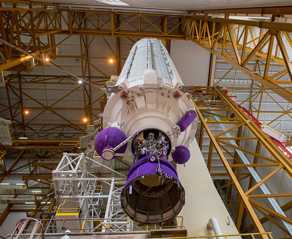
    The next Arianespace rocket to orbit Galileo satellites has begun taking shape at the spaceport in French Guiana, reported Arianespace. Build-up of the heavy-lift vehicle is now underway inside the spaceport’s Launcher Integration Building.

    Following the established assembly flow, the rocket build-up began with this week’s positioning of the launch vehicle’s central core cryogenic stage over one of two mobile launch tables used for Ariane 5.

    Ariane 5’s two solid propellant boosters are rolled out. (Photos: Arianespace)

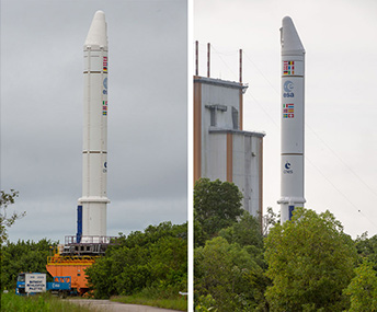
    It was followed by integration of the two large solid propellant boosters — installed directly on the launch table and mated to the core stage — clearing the way for placement of the upper stage, topped off with the vehicle equipment bay.

    Once the Ariane 5’s basic build-up is completed under the direction of production prime contractor ArianeGroup, it will be moved to the spaceport’s Final Assembly Building for installation of its four Galileo FOC (Full Operational Capability) satellite passengers, which are undergoing their own pre-flight preparations at the spaceport.

    The Ariane 5 will deploy its satellite passengers at a targeted orbital altitude of 23,222 kilometers in circular medium Earth orbit. The launch is designated Flight VA244 by Arianespace.

    Galileo satellites arrive

    In early June, Galileo satellites 25 and 26 landed at Europe’s Spaceport in Kourou, French Guiana, joining their two predecessors, satellites 23 and 24, according to the European Space Agency (ESA).

    One of the two Galileo satellites 25 and 26 is unloaded from a Boeing 747 cargo jet at Cayenne – Félix Eboué Airport in French Guiana on June 1. The satellites travel inside protective air-conditioned containers. (Photo: ESA)

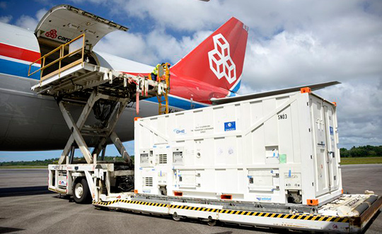
    The pair left Luxembourg Airport on a Boeing 747 cargo jet on the morning of June 1, arriving at Cayenne – Félix Eboué Airport in French Guiana that evening.

    After they were off-loaded, they were driven by truck to the cleanroom environment of the S1A payload preparation facility at Europe’s Spaceport, still in their protective air-conditioned containers. In the cleanroom, they joined Galileo satellites 23 and 24, which arrived last month.

    The cryogenic main stage of the Ariane 5, known as the EPC — from its French title Etage Principal Cryogénique — arrived by sea at French Guiana’s Port Pariacabo on May 30.

    A further 12 Galileo “Batch 3” satellites were ordered in 2017, supplementing the 26 built so far to provide further in-orbit spares and replacements for the oldest Galileo satellites, first launched in 2011.

    A steady stream of orbital spares, ready to replace satellites reaching the end of their operational lives, is essential to ensure Galileo continues operating seamlessly, according to ESA.

    Looking further ahead, with the aim of keeping Galileo services as a permanent part of the European and global landscape, new satellites will be required by the middle of the next decade, offering improved performance and added features.

  • FAA restricts drones over federal prisons, Coast Guard bases

    The Federal Aviation Administration (FAA) has established temporary unmanned aircraft system (UAS) flight restrictions over federal penitentiaries and U.S. Coast Guard bases.

    The restrictions, which take place June 20, are for drone flights up to 400 feet within the lateral boundaries of the facilities.

    The restrictions came at the request of federal security partners the Department of Justice (DOJ) and Department of Homeland Security (DHS).

    The FAA is using its existing authority under Title 14 of the Code of Federal Regulations (14 CFR) § 99.7 — “Special Security Instructions” — to address concerns about drone operations over these facilities,” the agency stated.

    Information on the FAA Notice to Airmen (NOTAM), which defines these restrictions, and the covered locations, can be found on the FAA’s UAS website. Broader information regarding flying drones in the National Airspace System, including frequently asked questions, is also on the FAA website.

    An interactive map, downloadable geospatial data and other important details can be found here.

    A link to the restrictions is also included in the FAA’s B4UFLY mobile app.

    This is the first time the FAA has placed specific flight restrictions for unmanned aircraft over Federal Bureau of Prisons and Coast Guard facilities. The FAA has placed similar flight restrictions over military installations that remain in place, as well as over 10 Department of Interior facilities and seven Department of Energy facilities.

    Operators who violate the flight restrictions may be subject to enforcement action, including potential civil penalties and criminal charges.

    There are a few exceptions that permit drone flights, which must be coordinated with the individual facility or the FAA.

    The FAA is considering additional requests by eligible federal security agencies for UAS-specific flight restrictions using the agency’s §99.7 authority as they are received. Additional changes to these restrictions will be announced by the FAA as appropriate.

    The following facilities will have the new restrictions:

    United States Penitentiaries (USP)

    USP Tucson near Tucson, AZ
    USP Atwater near Atwater, CA
    USP Victorville near Victorville, CA
    USP Florence High near Florence, CO
    USP Florence ADMAX near Florence, CO
    USP Coleman I near Sumterville, FL
    USP Coleman II near Sumterville, FL
    USP Marion near Marion, IL
    USP Terre Haute near Terre Haute, IN
    USP Big Sandy near Inez, KY
    USP McCreary near Pine Knot, KY
    USP Pollock near Pollock, LA
    USP Yazoo City near Yazoo City, MS
    USP Allenwood near Allenwood, PA
    USP Canaan near Waymart, PA
    USP Lewisburg near Lewisburg, PA
    USP Beaumont near Beaumont, TX
    USP Lee near Pennington Gap, VA
    USP Hazelton near Bruceton Mills, WV

    United States Coast Guard (USCG) Bases

    USCG Baltimore Yard, MD
    USCG Base Boston, MA
    USCG Base Alameda, CA
    USCG Base Los Angeles/Long Beach (LALB), CA
    USCG Base Elizabeth City, NC
    USCG Base Kodiak, AK
    USCG Base Miami, FL
    USCG Base Portsmouth, VA
    USCG Base Seattle, WA
    USCG Operations System Center (OSC) near Martinsburg, WV

  • Ukrainian MiG-29 fighter jet upgraded with GNSS navigation

    Ukrainian MiG-29 fighter jet upgraded with GNSS navigation

    A Ukranian MIG-29. (Photo: Ministry of Defense, Ukraine)
    A Ukranian MIG-29. (Photo: Ministry of Defense, Ukraine)

    Ukrainian Lviv Aircraft Repair Plant is upgrading the country’s MIG-29 fighter jets with domestically developed GNSS-assisted navigation capability, reports defenseworld.net.

    GNSS data will be viewed on a 8-inch, highly informative Cockpit display alongside the map of the terrain being overflown, target data and weapons parameters.

    Also being upgraded is the jet’s air-to-ground and surface attack capability, making it a “multi-role” fighter aircraft.

    The air-to-ground capability will be achieved through the use of TV-guided missile-bomb weapons of the X-29T and KAB-500KR types. The MiG-29 was originally designed as an air-superiority fighter to provide cover to ground attack planes such as the MiG-21.


  • China to launch 11 more BeiDou-3 satellites this year

    China will launch 11 more BeiDou-3 satellites by the end of 2018, according to the Xinhua News Agency, the official state-run press agency.

    China has already launched eight BeiDou-3 satellites for its domestic BeiDou Navigation Satellite System. The satellites will provide initial services for countries and regions along the Belt and Road by the end of the year, said Wang Li, chairman of the China Satellite Navigation System Committee.

    Addressing the Ninth China Satellite Navigation Conference in Harbin, capital of northeast China’s Heilongjiang Province, Wang said the BeiDou system is moving to become a global service provider after offering stable and reliable time and space information for clients in the Asia-Pacific region.

    China launched the first two BeiDou-3 satellites into space via a single carrier rocket in November 2017, as its self-developed BeiDou system officially began to expand into a global network.

    Compared to earlier generation satellites, the BeiDou-3 is able to send signals that are more compatible with other satellite navigation systems and provide satellite-based augmentation, as well as search-and-rescue services in accordance with international standards. Its positioning accuracy has reached 2.5 to 5 meters.

  • ION JNC early bird registration deadline is June 15

    ION JNC early bird registration deadline is June 15

    The Institute of Navigation’s (ION’s) Joint Navigation Conference (JNC) 2018 early bird registration deadline is Friday, June 15.

    The JNC, sponsored by the Military Division of the Institute of Navigation, will be held July 9-11 in a U.S. only, For Official Use Only (FOUO) environment at the Hyatt Regency Long Beach in Long Beach, California. The U.S.-only classified sessions will be held July 12 at The Aerospace Corporation.

    According to ION, early registration can save $200 on conference registration fees by entering a reservation confirmation number from the Hyatt Regency Long Beach at the start of the registration process. Attendees will need a valid hotel confirmation number to claim the discount during registration.

    Registration can be completed here.

    Attendance Restricted

    Conference attendance for both FOUO U.S. only (July 9-11) and U.S.-only classified sessions (July 12) will be screened by the Joint Navigation Warfare Center and will be restricted to U.S. only.

    Admission to the classified session will be limited to the capacity of the room and will be allocated on a first-come, first-served basis, to those who submitted visit requests in advance. Attendees requiring onsite security validation will be processed on a space-available basis. You are encouraged to submit your visit request early.

  • Victoria seeks suppliers for digital cadastre upgrade

    Victoria, Australia, is seeking to upgrade its digital cadastre, and is seeking industry interest. The Department of Environment, Land, Water and Planning (DELWP) has issued a market notification for industry on Digital Cadastre Modernisation (DCM).

    DELWP has two related procurement processes in May and July 2018.

    1. Request for Tender (RFT) 338298 for cadastral data back capture services was issued by DELWP on May 28, 2018.
    2. A related Expression of Interest (EOI) will be released for the remaining stages of the DCM, (adjustment, integration and automation phases) on or about July 31. Potential suppliers will be asked to register their interest and outline their capability to deliver and innovate across one or multiple stages. Further procurement steps are anticipated in 2019.

    Four inter-related stages of the DCM are expected to go to market. The tender notice described here relates to the first stage – back capture (RFT process 338298).

    DELWP is upgrading the spatial accuracy of the state’s digital representation of property boundaries (the authoritative digital cadastre) for the state’s 3.3 million properties. An upgraded digital cadastre will deliver significant quality and efficiency improvements for sectors including land development, surveying, planning, utilities, emergency services and infrastructure development. The DCM will deliver spatial accuracy of up to 0.1 metre for urban and 0.5 metres for rural land.

    STAGE 1 – Back capture: This stage will accurately capture specified data from PDF copies of registered plans and cadastral surveys into digital format LandXML files. This stage will also include the capture of particular features from aerial imagery.

    The tender will seek proposals to deliver back-capture services for the entire state. Key information relating to the tender includes:

    • The scope should be broken into a minimum of three packages (a maximum of 1.3m parcels in any package), and the initial contract will be for only the first package.
    • Bidders should scope these packages in a manner which they believe will best meet DELWP’s objectives (around the most accurate and efficient delivery of the upgraded digital cadastre).
    • Subject to satisfactory delivery of the first contract, the successful bidder may be contracted to deliver the remaining packages.
    • Alternate proposals are encouraged, should bidders identify an opportunity to deliver better outcomes or innovation by combining the back capture stage with another DCM stage (outlined below).

    Future procurement / future DCM stages (June EOI)

    Three future stages of the DCM which will be outlined in the July EOI are briefly described below.

    STAGE 2 – Adjustment: Initially, the analysis and validation of the back captured data obtained from stage 1 will be required. This will be followed by calculation and validation of the coordinates and uncertainties for all land parcel corners from back captured files and Victoria’s Survey Control Network. DELWP has bespoke software that may assist with the adjustment process, which can be licensed free of charge to the service provider.

    STAGE 3 – Integration: Integrating the upgraded digital cadastre from STAGE 2 into the state’s authoritative map base (Vicmap). Note that the DCM upgrade coincides with the next re-tender of the ongoing maintenance contract for Vicmap, and it is possible there will be an opportunity for vendors to bid for both the integration stage and ongoing maintenance.

    STAGE 4 – Automation: Enhancing DELWP’s existing corporate systems to fully automate the process of updating Victoria’s digital cadastre with new data (such as new sub-divisions) lodged in a digital format through SPEAR.

    A fifth and essential aspect of the project relates to change management; this will run throughout delivery.

    For more information contact [email protected], DCM program manager.

  • RIN’s 2018 International Navigation Conference set for November

    The International Navigation Conference, sponsored by the Royal Institute of Navigation (RIN), is a premier forum for the presentation of research and advances in navigation.

    The 2018 conference — the RIN’s fourth — will take place Nov. 12-15 in Bristol, England, United Kingdom.

    INC2018 brings together industry, academia and governments from around the world. The theme for INC2018 is “Navigation Challenges and Societal Benefits.”

    Conference topics include

    • Developments in resilient PNT
    • Innovations
    • PNT for connected autonomy
    • Human factors and cognition in navigation
    • Mapping and imaging
    • Progress in quantum technology

    Download the call for papers here. Abstracts can be submitted using the form at the bottom of this page.

  • PCTEL launches multi-GNSS L1/L2/L5 antennas for precision navigation

    PCTEL launches multi-GNSS L1/L2/L5 antennas for precision navigation

    PCTEL Inc. has launched a new series of multi-GNSS L1/L2/L5 antennas for precision navigation and timing.

    According to the company, the antennas combine aerospace-level precision with global satellite compatibility, in a highly durable package. They enable critical applications including vehicular automation, 5G network timing synchronization and Positive Train Control (PTC) systems.

    The company made the announcement at the RSSI C&S Exhibition (Railway Systems Suppliers Inc.) being held this week in Omaha, Nebraska.

    PCTEL’s multi-GNSS L1/L2/L5 antennas increase the accuracy of timing and location information by providing simultaneous access to multiple GNSS signals across multiple frequency bands. The antennas support all relevant GPS, GLONASS, BeiDou and Galileo frequencies with excellent multipath mitigation and high out-of-band rejection for greater signal clarity, the company said. Their robust AAR and IP67-compliant design makes them suitable for years of use on railways and in other harsh real-world environments.

    “Precision navigation is crucial for the next generation of autonomous vehicle technologies, which could drive major improvements in safety and efficiency across a wide variety of industries,” said Rishi Bharadwaj, senior vice president and general manager of PCTEL’s Connected Solutions group. “PCTEL’s new antennas make precision navigation accessible for large-scale deployments in rail, public safety, agricultural and commercial fleets. They also enable commercial deployments of 5G networks, which have higher accuracy requirements for network timing.”

    Earlier this month, PCTEL released its 900-MHz MIMO Yagi antennas with dual polarization., designed for use with MIMO or diversity radios in advanced supervisory control and data acquisition (SCADA) systems and other industrial internet of things applications. PCTEL’s dual polarized antenna technology improves data throughput and reliability on both licensed and unlicensed spectrum.

    PCTEL is displaying its new multi-GNSS antennas along with other antenna solutions for the rail industry, May 22-23 at the RSSI C&S Exhibition, booth #1109. The new antennas will be available for purchase in mid-July.

  • GPS actively monitoring Kilauea’s eruptions, lava flows

    GPS actively monitoring Kilauea’s eruptions, lava flows

    GPS measurements are playing a key role in monitoring the erupting Kilauea volcano in Hawaii.

    The floor of the Pu’u ‘O’o Crater started to collapse on April 30, following weeks of uplift and increasing lava levels within the cone and seismicity in the East Rift Zone. The eruptions began on May 3, when a magnitude 5 earthquake struck, causing further collapse of the crater.

    The Hawaiian Volcano Observatory (HVO) has monitored volcanic activity on the islands since 1912. The HVO is operated by the U.S. Geological Survey (USGS) and is issuing continuous updates on Kilauea.

    The HVO is closely monitoring the biggest fissures in what is known as the lower East Rift Zone. Geologists are onsite to track ongoing and new fissure activity and the advance of lava flows.

    Kilauea eruption map as of 8 a.m. HST, May 21. Shaded purple areas indicate lava flows erupted in 1840, 1955, 1960 and 2014–2015. (Photo: USGS)

    GPS stations monitor land movement of Kilauea. The Big Island’s most active volcano has erupted nearly continuously for more than three decades.

    “Magma supplied to the Lower East Rift Zone was indicated by the northwest displacement of a GPS monitoring station,” the HVO said in its May 26 status update, but the station ceased movement a few hours later, telling a new story.

    “Magma continues to be supplied to the Lower East Rift Zone; however, a GPS instrument near the Lower East Rift Zone is no longer moving, suggesting that the rift zone is no longer inflating in this area,” the HVO stated. “Elevated earthquake activity continues, but earthquake locations have not moved farther downrift in the past couple of days.”

    Map of GPS stations installed near the Pu’u O’o vent on Kilauea. (Photo: USGS)

    The GPS stations also monitor earthquake activity associated with the volcano. For instance, the May 4 magnitude 6.9 earthquake resulted in seaward motion of 1.5 feet along portions of Kīlauea’s south flank as measured by GPS stations across the volcano.

    “Because active volcanoes make for unstable land, highly sensitive seismometers come in handy to track the frequency and strength of micro-earthquakes,” the HVO explained. “Global Positioning System (GPS) devices and another satellite-based technology, InSAR (Interferometric Synthetic Aperture Radar), map ground deformation (inflation and deflation) to within a fraction of an inch while tiltmeters measure slope from ground level. Together, these technologies help track lava’s movement underground and help pinpoint where it might break through the surface.”

  • Galileo Reference Centre inaugurated in the Netherlands

    Galileo Reference Centre inaugurated in the Netherlands

    News from the European GNSS Agency (GSA)

    The Galileo Reference Centre (GRC), the new state-of-the-art performance monitoring hub for the European Union’s global satellite navigation system, was officially inaugurated May 16 in Noordwijk, the Netherlands.

    The ceremony was presided by Dutch Minister of Infrastructure and Water Management Cora van Nieuwenhuizen and European GNSS Agency (GSA) Executive Director Carlo des Dorides, among others.

    GSA Executive Director Carlo des Dorides (right), Dutch Minister for Infrastructure and Water Management Cora van Nieuwenhuizen, and DG GROW Deputy Director-General Pierre Delsaux at GRC inauguration. (Photo: GSA)

    “The Galileo Reference Centre is a state of the art facility that underpins Galileo service provision,” des Dorides said. “The GRC will be instrumental in monitoring the performance of the system and of the service operator, ensuring that users benefit from the most reliable satellite data and, at the same time, disclosing new service potential.”

    “I am proud of the fact that the Galileo Reference Centre is located in the Netherlands,” van Nieuwenhuizen said. “The data provided by Galileo will enable us to navigate with an accuracy to within 20 centimeters. In rescue operations, this sharp reduction in response time is going to save human lives.”

    Independent monitoring ensures quality for users

    The GRC is a cornerstone of service provision for Europe’s Galileo satellite constellation and plays an important role in Galileo’s operations, providing the GSA with an independent means of evaluating the quality of the signals in space and the performance of the Galileo Service Operator (GSOp). In so doing, it helps ensure the provision of high-quality satellite data so users can better rely on and benefit from Galileo.

    Managed by the GSA, the GRC is comprised of a core facility in Noordwijk and contributions from EU Member States, Norway and Switzerland. From the core facility, the GRC generates performance evaluation products and reports using data collected in-house and through cooperation with Member States. The Centre also performs dedicated campaign-based analyses to support investigation of any service performance issues and reports on its findings.

    In this two-pillar approach, the GRC benefits from and contributes to maintaining long-term competence and expertise at the Member State level, and actively integrates contributions from the EU Member States, Norway and Switzerland to support daily operations and specific campaigns.

    The GSA has established agreements with two beneficiaries, one led by the French Space Agency (CNES) and the other by the Netherlands Aerospace Centre (NLR), and 23 organizations from 14 different countries. Member State contributions include data from networks of reference stations and campaigns using vehicles, vessels and airplanes, and reference products.

    The GRC is fully independent of the system and the Galileo Service Operator with respect to its operations.

    Since June 2017, GRC operations were hosted and operated from a temporary facility at ESTEC, the neighbouring ESA technical centre, which was instrumental in the swift ramp-up of competences. In April the GRC moved to its new home.

    Earlier in May, the GRC hosted representatives from US GPS, Russian Glonass, Chinese BeiDou, Japanese QIS and Galileo to discuss the creation of an authoritative international GNSS monitoring and assessment system to benchmark the performance of available GNSS. The meeting was organised through the International GNSS Monitoring and Assessment Task Force of the United Nations Office of Outer Space Affairs (UNOOSA), International Committee on GNSS (ICG).

  • Driver safety highlighted in new GPS tracking solution for fleets

    Teletrac Navman, a global software-as-a-service provider that leverages location-based technology for GPS tracking solutions, has launched its fully integrated Driver Safety Analytics Solution.

    Part of the Teletrac Navman Director platform, the safety analytics solution combines GPS tracking data and event replays, dashboard camera technology, driver scorecards and analytics on a single platform so fleet managers have all the information needed to reduce risks and implement safe driving practices across their fleets, the company said.

    “I have a full view into safety and the solution makes everything fact-based. Before I had perceptions of how my drivers behave on the road, but now I have proof,” said customer Bonnie Lantz, director at P&B Transportation. “I can see training needs and, of equal importance, our drivers’ incredible defensive driving when cars around them behave erratically. Our insurance company and drivers both wanted the cameras, and I expect it will save us money and give our whole fleet a better grasp on safety.”

    The Director Safety Analytics module provides insight into driver-specific and fleet-wide behavior to create a safety-focused culture, recognize and retain great drivers, and improve the insurance claims process. Features include:

    • The Integrated Event Viewer lets fleets simultaneously view driving event replays and unsafe behaviors on Google Maps, using GPS tracking data, and second-by-second Dashboard Camera video footage for quick response to and resolution of incidents.
    • Front-Facing Dashboard Cameras continuously record HD quality video footage, with recordings of all events stored in the cloud. In addition to getting a complete picture of events, footage can be used as supporting material in the event of an insurance claim and to protect against driver fault in accidents.
    • Driver Scorecards track and rank driver improvements over time for personalized training, in combination with event replay and live footage, and to recognize positive driver behaviors.
    • Reporting & Alerts measures speeding, harsh breaking, erratic cornering and other dangerous behaviors through GPS tracking and proactively alerts fleet managers. It lets fleet managers build dashboards around safety KPIs and do in-depth evaluation on fleet-wide and individual driver safety performance to easily communicate performance trends, create targeted improvement plans and build incentive programs that encourage safe driving.

    “We built this solution to give fleets absolutely everything they need to build a culture of safety,” said Daren Lauda, general manager of North America, Teletrac Navman. “The high-level fleet benchmarking is easy to drill down into to understand how individual drivers are performing. Add in the integrated telematics and corresponding video footage and fleet managers have a complete, real-life picture of safety to fuel individualized training, track progress and protect their drivers in incidents.”

  • Abstracts due for ITSNT 2018

    Abstracts are due May 25 for the International Technical Symposium on Navigation and Timing, also known as the ITSNT.

    ITNST is an annual event organized by Centre National d’Etudes Spatiales (CNES) and Ecole Nationale de l’Aviation Civile (ENAC) for professionals and researchers working with or interested in navigation and timing technologies and their use.

    The 2018 edition of the ITSNT will take place Nov. 13-16 in Toulouse, France, on the campus of ENAC.

    This event is composed of two types of sessions:

    • Invited Guest sessions: special guests are invited by the scientific committee to give a presentation related to the generic topic of the session. Typically, there are four guest speakers per session, and the session ends with a round table. The programme of the “invited guest” sessions is available on the website.
    • Peer-Reviewed Paper sessions: the presenters of these sessions are selected by the scientific committee based on a call for abstract. The deadline for the call for abstracts is May 25. The final programme of these sessions will be available in October.

    The ITSNT also provides a great environment for networking and visiting sponsors’ exhibition stands.

    The symposium includes tutorials given by some of the invited guest speakers on their topic of excellence.

    Click here for more information on the call for abstracts and how to submit them.