The cylinder shows the polarization states that the bio-inspired detector observes; polarization states predicted by the single-scattering model. (Image: Study authors)
With so many recent improvements in navigation, positioning and mapping, you’d think we could place things pretty much anywhere on the globe.
But what about under the ocean? Satellite-based GPS only works to a depth of about 20 centimeters.
To find a new method of underwater positioning, an international team of researchers turned to the humble shrimp. The crustacean uses polarization — the bending, refracting and scattering of light as it passes through water — to find its way.
The team is developing an underwater geo-localization system that uses polarization of light to calculate the position of objects. The study, published in the April issue of the journal Science Advances, carries the promise of increased accuracy in navigation, exploration and deep-sea search-and-rescue missions.
“The rich repertoire of underwater polarization patterns — a consequence of light’s air-to-water transmission and in-water scattering — can be exploited both as a compass and for geolocalization purposes,” write the authors. “We demonstrate that, by using a bioinspired polarization-sensitive imager, we can determine the geolocation of an observer based on radial underwater polarization patterns. Our experimental data, recorded at various locations around the world, at different depths and times of day, indicate that the average accuracy of our geolocalization is 61 km, or 6 m of error for every 1 km traveled.
“This proof-of-concept study of our bioinspired technique opens new possibilities in long-distance underwater navigation and suggests additional mechanisms by which marine animals with polarization-sensitive vision might perform both local and long-distance navigation.”
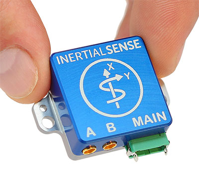
Inertial Sense has announced the availability of a micro-sized rugged version of its combined GNSS-INS module, which has an onboard GNSS receiver as well as a fully fused inertial navigation solution.
Designed to fill autonomous vehicle and sensing needs, the module is also available in AHRS/IMU versions.
At 10 grams and with 1 x 1-inch footprint, the solution provides accuracy of 0.1-degree roll/pitch and 0.3-degree dynamic heading. It is also ITAR-free module.
The modules represent 15 years of inertial navigation and motion measurement experience, according to the company.
“When I set out on this journey to provide an accurate and low-cost navigation solution, I wanted to produce a product that engineers could purchase off the shelf, hassle free,” said company founder Walt Johnson. “In my past as a UAV engineer, I was always looking for ways to save myself time and money. It’s all about convenience. There is no need to spend time choosing IMU sensors and writing the algorithms to fuse navigation data. We provide it all for you.”
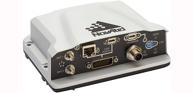
NovAtel has introduced several new precision positioning solutions for space-constrained applications. With enhanced positioning accuracy in a compact form, the PwrPak7D, PwrPak7DE1 and OEM7600 are suitable for automotive, airborne and other smaller unmanned systems.
PwrPak7D and PwrPak7D-E1 are dual-antenna, multi-frequency enclosures, and the OEM7600 receiver board, plus NovAtel’s new Waypoint Inertial Explorer Express post-processing software are being showcased this week at AUVSI Xponential 2018.
Dual-Antenna, Multi-Frequency Enclosures
The new PwrPak7D enclosure. (Photo: NovAtel)
NovAtel’s new PwrPak7D and PwrPak7D-E1 enclosures provide space efficiency without sacrificing position accuracy and heading stability, even in stationary, slow-moving or hovering dynamics.
The PwrPak7D-E1 enclosure integrates an inertial measurement unit (IMU) with NovAtel’s OEM7720 dual-antenna receiver board to deliver GNSS and inertial navigation system (INS) capabilities.
When combined with NovAtel’s SPAN technology, positioning and attitude performance is optimized during extended GNSS outages.
Both the PwrPak7D and PwrPak7D-E1 include NovAtel’s Interference Toolkit with advanced interference detection
and mitigation features applicable to all stages of integration. A web user interface, accessible through Ethernet or
Wi-Fi, allows for quick and easy system configuration and control.
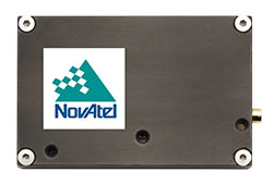
OEM7600 Receiver Board for Smaller Autonomous Systems
The OEM7600 receiver board. (Photo: NovAtel)
The OEM7600 receiver board features NovAtel’s high-performance positioning solutions in an extremely small form factor, wrapped with protective shielding to isolate emissions from surrounding electronics in confined spaces.
This new receiver integrates easily with NovAtel’s SPAN technology to optimize performance during extended GNSS outages.
The new OEM7600 will be commercially available this summer.
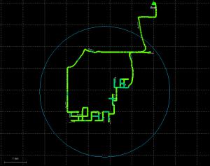
New Post-Processing Software for UAVs and Small Project Areas
Inertial Explorer Xpress centroid circle. (Image: NovAtel)
Inertial Explorer Express provides the same core processing and utilities as the
Waypoint Inertial Explorer software for applications including unmanned aerial vehicles (UAVs) and smaller projects.
Inertial Explorer Express will produce centimeter-level position and attitude solutions compatible for lidar, camera and other sensor data with faster processing times and reduced complexity
“We are very excited to be introducing our new OEM7-based and Inertial Explorer solutions at Xponential 2018,” said Neil Gerein, director of product management at NovAtel. “These systems provide robust positioning and accuracy in a compact footprint for UAVs and smaller autonomous projects. An advanced range of software options, including NovAtel’s tightly coupled GNSS+Inertial SPAN technology and Interference Toolkit, provide assured positioning anywhere.”
Measurement results become quicker and more accurate with the gps 70 T’s permanent tilt compensation, resistance to magnetic interferences and calibration-free usage.
With the iCON gps 70 T, construction professionals can measure and stake out points without having to keep the pole vertical to level the bubble. According to the company, it allows the user to look at the immediate environment — for other people, machines, excavations, motor vehicles and structures — rather than on the bubble.
The combination of the latest GNSS technology and inertial measurement unit (IMU) equips the gps 70 T with its true tilt compensation. The tilt compensation extends the measurement possibilities, improves quality and accuracy of the collected data, and reduces errors.
The iCON gps 70 series is seamlessly integrated into the version 4.0 of the iCON field software. By keeping the core central interface, users will benefit from the simple-to-use workflows that require less training and avoid costly downtime.
According to Phase One Industrial, the iXM 100MP is a high-productivity metric camera with a range of high-resolution lenses. Photo by Allison Barwacz
Phase One Industrial has launched the iXM series, an aerial camera platform driven by its fast medium-format imaging sensor.
Engineered for UAV-imaging missions, the iXM 100MP is a high-productivity metric camera with a range of high-resolution lenses. It is ready for integration with various UAV platforms, including Phase One’s DJI Matrice 600 Pro solution.
The iXM 100MP metric camera incorporates the first medium-format sensor with backside-illumination technology, enabling high light sensitivity and extended dynamic range. Fast, highly responsive, robust and weatherproof (IP53 compliant), the iXM 100MP delivers superior quality aerial imaging and flexible operation to satisfy diverse mapping, surveying and inspection applications, the company said.
In addition, Phase One announced four new specially developed RSM lenses — with focal lengths ranging from 35mm to 150mm — to seamlessly fit the new sensor’s 3.76 μm pixel size and 33 x 44 mm frame size, ensuring image sharpness across the entire FOV. The lenses are available with either fixed-focus or motorized-focus functionality.
The fixed-focus 35mm and 80mm lenses provide superior image radiometric quality, high ground resolution and large coverage, suitable for surveying applications.
The motorized-focus 80mm and 150mm lenses are designed for a wide range of inspection applications, including electricity poles, wind turbines, bridges, and other private-sector or government structures.
Motorized-focused lenses, having no external moving parts, enable a number of new uses for inspection applications where the focusing distance can be predefined based on flight planning, or by the operator, using a wireless remote control. With the motorized lens, the camera captures sharp and highly detailed images of multi-distance or 3D objects.
The cameras’ RSM lenses incorporate a new leaf-shutter technology, which supports 3 fps capture — with a speed of 1/2500 sec — while guaranteeing 500,000 actuations. The lenses are thermally stable to ensure consistent focus over a wide range of temperatures and flight altitudes.
With optics designed to exploit the full benefits of the new sensor technology, the lenses provide with greater productivity, flexibility and reliability, offering superb image quality.
The new iXM platform adds XQD high-speed storage technology to handle the sensor’s extremely fast frame rate. Also on all cameras, HDMI output from actual exposure provides UAV operators simple and outage-free feedback of actual view, exposures, and camera status in overlays.
In addition, the new platform includes USB-C and 10G Ethernet for versatility of connectivity to large UAVs and aircraft.
“Working with our UAV partners, we see a fast-growing market driven by great potential for time and cost savings over traditional inspection and surveying methods,” said Dov Kalinski, General Manager of Phase One Industrial. “With its new technology, design, and capabilities, the iXM 100MP promises to help start a new era in inspection missions with UAVs. Phase One Industrial continues to push technical boundaries to equip drones and larger UAVs with superior imaging technology — engineering advanced systems, cameras, and software — to help achieve that potential.”
The iXM 100MP and iXM 50MP metric cameras are available for advance order from Phase One Industrial partners worldwide with delivery in June 2018.
The decision means Lockheed Martin is all but assured the contract. Lockheed Martin announced on April 17 that it had submitted its proposal.
All three companies received study contracts in 2016 valued at up to $6 million each to demonstrate their ability to build future GPS satellites, in preparation for the planned competition.
The U.S. Army has awarded to Orolia subsidiary McMurdo a $33,986,800 contract to manufacture Personnel Recovery Devices (PRD) for warfighters. The contract is for indefinite-delivery/indefinite-quantity, with an estimated completion date of March 6, 2022.
The PRD is a dual-mode, MIL-SPEC locator beacon that will be integrated into the Army’s Personnel Recovery Support System (PRSS). It will be capable of transmitting both open and secure signals to alert and notify that a soldier has become isolated, missing, detained or captured.
The positioning device will optimize a successful rescue operation for soldiers in a distress situation through secure enhanced capabilities. It has been designed to meet military standards and specifications, and has improved accuracy, decreased size, weight and power (SWaP) requirements.
“We are extremely proud and honored to have been selected by the US Army as the provider of this critical positioning device for the safety of U.S. warfighters,” said Jean-Yves Courtois, CEO of Orolia. “Easy to incorporate into Personnel Recovery operations, the PRD is based on Orolia’s new rugged and small PNT platform dedicated to dismounted soldier Assured PNT applications.”
“This award, which follows the 2016 contract from the U.S. Coast Guard to produce 16,000 FastFind 220 personal locator beacons, is a testimony to Orolia’s world leadership in Resilient Positioning, Navigation and Timing,” he said.
The Personnel Recovery Support System Personnel Recovery Device contract was awarded by the U.S. Army Contracting Command, Aberdeen Proving Ground, Maryland, on behalf of the Army Air Warrior Product Management Office at Redstone Arsenal in Huntsville, Alabama.
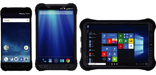
Hemisphere GNSS has launched a new UT series of GNSS-capable rugged handheld devices to support industries such as construction, survey, GIS, mapping, asset/logistics management, public safety, utilities and military.
The UT handheld devices are designed to work in the harshest environments imaginable and offer impressive and powerful feature sets.
Hemisphere made the announcement at Intermat Paris 2018, where it is exhibiting at stand 6 J 027.
The UT10 6-inch rugged phone and UT30 8-inch rugged tablet both feature Android 8.0 operating systems with Qualcomm octa-core 2.2 GHz processors, 4 GB of RAM, and 32 GB onboard storage.
The UT50 10.1-inch full-rugged tablet features the Windows 10 operating system with an Intel Core Skylake i5 processor up to 2.8 GHz, 8 GB RAM, and 128 GB of onboard storage.
According to the company, all three new UT models provide the latest high-resolution, capacitive touchscreen and direct sunlight-readable display technology for ease of visibility in all situations. The UT50 also has a 10-finger multi-touchscreen and supports wet hands and gloves operation.
The devices have dual built-in cameras. The UT10 and UT30 handhelds feature 13 MP rear and 5 MP front cameras.
The devices are designed to be drop-resistant from heights of 1.2 meters (1.5 meters for the UT10), are rated at IP67 (IP68 for UT50), and are certified to both MIL-STD-810G and MIL-STD-461F military standards to ensure durability in most outdoor or challenging environments.
The UT10 and UT30 are powered by single 8,000m Ah and 8,200 mAh batteries with Qualcomm Quick Charge 3.0 technology, while the UT50 offers dual hot-swappable batteries at 2,900 mAh each so users can continue working in the field without powering down.
“With varying specifications and options between these devices, mobile workers are sure to find them suitable to fit their demanding work environments,” said Miles Ware, director of marketing with Hemisphere GNSS. “These powerful machines reflect the latest in hardware standards and are exceptional complimentary additions to our product portfolio.”
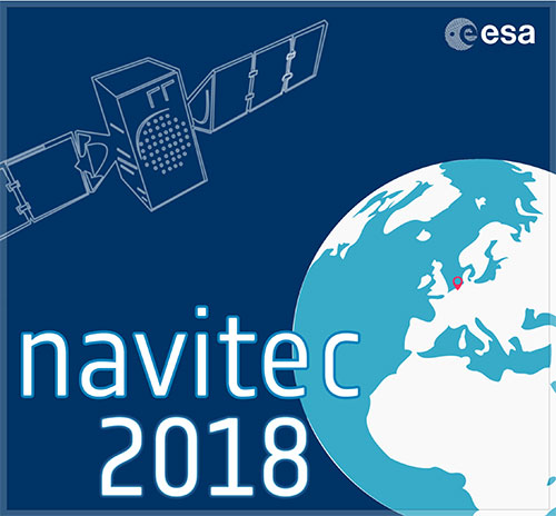
The ninth Workshop on Satellite Navigation Technologies, NAVITEC 2018, will be held Dec. 5-7 at the European Space Research and Technology Centre (ESTEC) in Noordwijk, the Netherlands.
The workshop, themed “Golden opportunities for PNT,” is organized by the Radio Navigation Systems Implementation & Verification Section of the Directorate of Technical and Quality Management, European Space Agency (ESA).
NAVITEC 2018 will include the GNSS Signals and Signal Processing Workshop in coordination with CNES, DLR and the University of the Federal Armed Forces Munich.
The aim of the workshop is to provide an open forum to space and terrestrial satellite navigation technology designers, developers, integrators, users, universities and agency representatives.
“We are now seeing an explosion of new applications using position and time,” stated an ESA event announcement. “People expect PNT to be available always and everywhere. Solutions require reliable service outdoors and indoors, high-accuracy and able to survive in challenging environments with new security threats. All this at ever lower prices. These solutions require innovative technologies such as integration with other sensors, cloud processing, low power technologies, all with the latest security measures.”
Participants will have the opportunity to share their technical expertise and experiences by formal presentations, informal discussions and round tables. The workshop will provide an overview of satellite navigation technologies that are available, or being developed, especially in the frame of current research and development programmes.
Scope and topics of interest
The scope of the workshop will include navigation equipment and techniques: receivers, payloads, signals, navigation algorithms, signal processing techniques and applications of GNSS (terrestrial and space).
A call for papers will be issued soon. The papers should describe new equipment developments and systems concepts, innovative technologies and designs, testing/validation procedures, linked to the topics that are listed below.
Mass-market GNSS/Galileo results
GNSS in IoT (low-power & snapshot processing)
Positioning and Timing for 5G
Cloud and collaborative positioning techniques and applications
Precise Positioning in challenging environments
Augmentation services
Interference, Spoofing and Authentication and Cyber Security
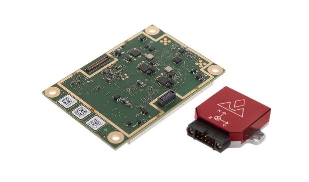
The AsteRx-i combines Septentrio’s latest compact, multi-frequency multi-constellation GNSS engine with an external industrial-grade MEMS-based inertial measurement unit (IMU). It can deliver accurate and reliable GNSS/IMU integrated positioning to the centimeter level as well as full 3D attitude at high update rates and low latency.
Key benefits for users:
IMU-enhanced GNSS positioning with full attitude: heading pitch and roll
AIM+ interference monitoring and mitigation system
High-update rate, low-latency positioning and attitude
Designed around demanding requirements for size, weight and power consumption, the AsteRx-i is suitable for optical inspection and photogrammetry.
Accompanied by a UAS-tailored carrier board, the AsteRx-i integrates seamlessly into light UAVs. The versatility of design and range of connection interfaces extend the AsteRx-i applicability to automation and robotics and as well as logistics.
The AsteRx-i includes Septentrio’s GNSS+ suite of positioning algorithms to convert difficult environments into good positioning: LOCK+ technology to maintain tracking during heavy vibration, APME+ to combat multipath and IONO+ technology to ensure continued position accuracy during periods of elevated ionospheric activity.
It also features AIM+ interference mitigation and monitoring system which can suppress the widest variety of interferers, from simple continuous narrowband signals to the most complex wideband and pulsed jammers.
“Complementing our GNSS portfolio with an INS offering is a natural evolution of our product range. At Septentrio, we design our GNSS solutions with a focus on reliability and availability. Smart integration of inertial sensors builds on these strengths to make affordable high-precision positioning and orientation solutions possible for ever more demanding applications,” said Francesca Clemente, product manager at Septentrio.
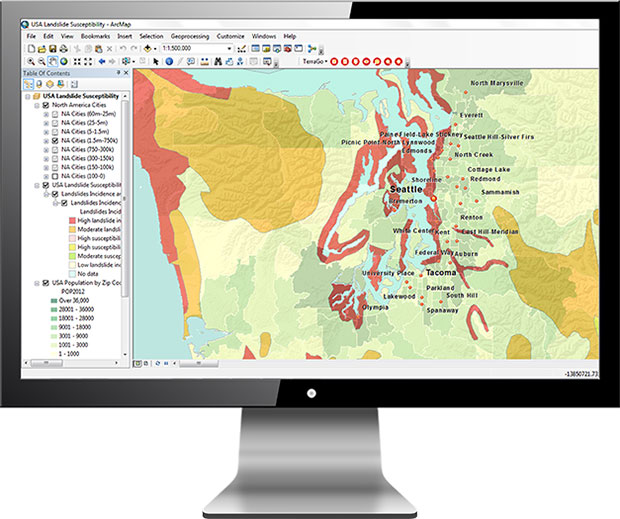
TerraGo has released TerraGo Publisher for ArcGIS version 7.4, which includes the ability to create and share GeoPDFs that convey important changes over time for an area of interest, with any type of map or imagery. The time-enabled visualization can animate geographic changes over time with interactive maps that can be shared with anyone using free Adobe Reader, the company said.
“Our customers can share these time-series map layers as a universally available GeoPDF, enabling non-GIS users to measure past conditions, assess changes over time, analyze trends and even project future scenarios,” said Scott Lee, director of federal programs at TerraGo. “Time-enabled GeoPDFs can help deliver important geographic analysis to the widest audience possible, which is incredibly valuable for sharing information with policy makers, agencies, stakeholders and constituents.”
Time-enabled, interactive maps can be used in any number of different geographic analysis use cases. Here are a few examples.
coastal populations impacted by rising sea levels
progress of recovery efforts for a hurricane disaster zone
forestry and environmental impacts due to policy change
shifting crime patterns in different types of city zones
satellite imagery showing impact of regional military conflicts on local populations
Version 7.4 includes additional enhancements and improvements including support for ArcGIS version 10.6.0.
TerraGo will also be showcasing the latest features at GEOINT 2018, the United States Geospatial Intelligence Foundation Symposium, which takes place April 22-25 in Tampa, Florida.
Hemisphere GNSS has made significant achievements with its GradeMetrix OEM toolkit for high-precision GNSS-based machine control and guidance applications and systems.
Hemisphere has expanded its portfolio of hardware offerings, including the A222 Scalable GNSS Smart Antenna introduced in November 2017, and made significant strides forward with its next-generation GradeMetrix OEM application software platform.
Whether it is grading, mining, excavating, drilling and piling, or compaction applications, heavy equipment manufacturers can rebrand the solution and drive feature requirements to sell as their own.
Hemisphere made the announcement at Intermat Paris 2018, where the company is exhibiting at stand 6 J 027.
The GradeMetrix toolkit allows OEMs to select components, a-la-carte or as complete solutions, based on their accuracy and durability requirements and integrate into their machines to design their own IP. This allows manufacturers to maintain a competitive advantage in the marketplace, as they do not have to compete with conventional or traditional machine control and guidance dealers selling aftermarket systems, the company said.
Hemisphere owns the design of the toolkit and its components and ensures each component is reliable with guaranteed compliance through design. The fully customizable and flexible toolkit provides the ability to tailor displays and outputs, per OEM requirements, and also offers OPA (open architecture) for implementing inputs and third-party sensors already available on machines.
Through UniStrong, Hemisphere’s parent company, the GradeMetrix toolkit also has seamless access to complimentary and innovative technologies. This allows for much faster times to market, driving increased revenue streams for OEMs, and provides a high cost/value ratio.
“The feedback we are receiving from OEMs already using our GradeMetrix toolkit is outstanding,” said Randy Noland, vice president of Global Sales & Business Development with Hemisphere GNSS. “For the first time in our industry, we are offering OEMs the opportunity to build their own machine control and guidance systems using their specifications and offering it to their customers, with their brand, 100% of the time.”
Manufacturers are looking for flexibility and price performance in existing system offerings or in new systems. Hemisphere continues to provide anfull system OEM positioning solution toolkit for building powerful, complete or a-la-carte machine control and guidance systems including GradeMetrix OEM application software and an array of compatible GNSS hardware components.
These include IronOne Rugged Display & Computer, A222 Scalable GNSS Smart Antenna, A326 Rugged GNSS Smart Antenna, Vector VR500 Rugged All-In-One Smart Antenna, Vector VR1000 Rugged GNSS Receiver, and C321+ RTK Base & Rover with SiteMetrix Site Management Software.