Boeing has decided to not submit a proposal to build up to 22 GPS III satellites for the U.S. Air Force. The GPS III Follow On (GPS IIIF) program will supply additional upgraded satellites to replace ones now in the constellation.
“We have not put in a proposal for GPS III,” said Rico Attanasio, Boeing’s director of Department of Defense and civil navigation and communications programs, to Space News.
Lockheed has been the only producer of GPS III satellites, and is now under contract to build the first 10. Boeing built earlier versions of GPS satellites.
In February, the U.S. Air Force Space Command (AFSC) released its request for proposals (RFP) to build the 22 GPS III satellites, called the GPS III Follow-On Phase 2 contract. The estimated dollar value of the acquisition is $10 billion including all options.
Phase 2 is planned as a single, predominantly fixed-price incentive-type contract awarded via full and open competition for production of 22 GPS III satellites. Deadline for proposals is April 16. Construction is to begin in fiscal year 2019 (Oct. 1, 2018), with delivery of the first satellite in 2026.
Boeing thought it could compete based on “innovation, resilience [and] a new payload, but that wasn’t emphasized,” Attanasio told Space News. “It wasn’t a good fit for us.”
An oblique image of downtown Chicago, captured in June 2017, with measurements. (Image: Nearmap)
Guest column by Sanchit Agarwal Vice President, Field Operations, Nearmap
With high-resolution imagery comes the ability to model reality, creating real-life visualizations for engineers, planners, construction teams and many others.
A quantum leap in computing capacity has allowed us to model and analyze the real world — all from our desktop and mobile devices. In days past, maps were purely for visualization and direction.
Today, they have graduated to full-blown analytics platforms empowering users to make decisions faster than ever before.
Why?
They closely represent truth on the ground — truth created from high-resolution aerial imagery captured at heights of up to 18,000 feet. Camera systems mounted in the bellies of planes can efficiently map the real world in incredible high detail. These aerial photographs are updated continuously.
In years past, access to aerial mapping content and services was reserved for more significant players.
Today, with easy access to scalable high-definition mapping content, anyone can utilize the power of maps in applications that extend far beyond directions and navigation.
There are two essential attributes of aerial maps driving this transformation — image resolution and model density. Today, most users are applying low-resolution satellite images that lack the detail needed for accurate decisions. But, as resolution increases, the imagery becomes more detailed; the visualizations, more vivid.
Ground features have gone from fuzzy satellite photos to clearly identifiable homes, buildings, roads, lakes and more — all captured using powerful cameras that have found the perfect pixel. With high-resolution comes added benefit.
Aerial image of the Aria Resort in Las Vegas captured in May 2017. (Image: Nearmap)
Users can manipulate the imagery — zoom closer and closer without losing the details. Computers can classify the features, distinguishing skylights from solar panels, walking paths from sidewalks, and pools from ponds.
Rich imagery is yielding richer data used to instantly query massive databases and return results that answer complex questions for businesses and government.
With high-resolution imagery comes the ability to model reality, creating real-life visualizations for engineers, planners, construction teams and others.
These models of landscapes, cities and neighborhoods are portrayed inside design tools and mapping systems, saving the analyst countless days of traveling to the site only to be surprised that the outdated low-resolution imagery does not depict what’s actually on the ground.
Imagery can vary greatly in resolution. Pixel resolution refers to the actual distance on the ground that each pixel represents in the orthophotography — the vertical image. For example, one-foot pixel resolution means that each pixel in the image covers one foot on the ground.
Common resolutions include three-inch, six-inch, one-foot and one-meter. The higher the imagery resolution (for instance, three inches per pixel), the greater the visible detail within the photograph. Clearly, a three-inch resolution is much better than a one-foot resolution.
Most mapping content currently consumed is two-dimensional and generated from low to mid-resolution nadir imagery. In other words, you see the land as if you were staring straight down at it, not height-of-ground features and certainly not change over time.
While that was adequate for some users, others reached for higher resolution and, while they were at it, decided they needed a third and fourth dimension — namely, height and time. These new perspectives provide more analytical options, more insights and a variety of new use cases that show change over time, height and multi-perspectives of the same property or landscape.
With the democratization of mapping products and services and the general trend toward consumption of multi-dimensional experiences, there is an implicit need to increase resolution, detail, dimensions and perspectives in mapping content and services as well.
The Rancho Mirage community of California, captured in February 2017. (Image: Nearmap)
Traditionally, satellite imagery has been used to monitor large areas of the earth at scale remotely. The resolution of the satellite imagery has graduated from multiple meters to feet with the advent of advanced mapping satellites.
The challenge here is the resolution. Low-resolution satellite imagery, although scalable, is good for macro-analysis of cities and neighborhoods but is not detailed enough for accurate measurements and micro-analysis at the level of each individual property.
On the other end of the spectrum come drone mapping solutions that offer the promise of delivering incredibly high-resolution datasets (sub-centimeter resolution) but fails to provide the scalability and repeatability.
Let’s get specific. Why does resolution matter?
You cannot measure what you cannot see. The resolution of imagery provides a more detailed, zoomed in and richer view of the real world, thereby enabling desktop based reconnaissance, inspection, analysis and measurement of features that are not traditionally visible in satellite imagery.
Higher resolution means high fidelity and dependable measurements. With the added details and definition of features that high-resolution offers comes the much-needed advantage of clearly and legibly identifying feature boundaries and hence measuring the feature with high precision and accuracy.
Higher resolution map content means fewer site visits. Rather than travel onsite to inspect and measure, many organizations are now relying on high-resolution imagery and, in the process, not having to waste resources sending team members on site.
High resolution means more detailed documentation of reality. Gamers have experienced reality-like landscapes for quite some time. Now, 3D and 4D mapping content allows users to immerse themselves in the landscape, navigate through street views, and fly like a bird to inspect rooftops with ease.
High resolution and refreshed content means more accurate change analysis. Identifying how locations have changed over time through multiple captures that embody leaf-off and leaf-on imagery allow users to not only visualize detail but also notice progress, changes in construction, degradation of property features, growth in vegetation and more.
High-resolution content means more automated workflows. High-resolution content allows for better feature definition models resulting in higher success rates in interpreting and analyzing the reality algorithmically. Higher success rates of automated algorithms results in efficient exploitation of datasets to solve real world problems.
Machine learning thrives on high-resolution content. There’s no shortage of news on the use of machine learning and artificial intelligence in data science. With the advent of high-resolution maps, machine learning is now able to differentiate skylights from solar panels, decks from patios and pavement from pavers. In turn, the ground features identified are being stored in databases for lightning fast queries to complex problems.
The higher the resolution, the higher your confidence will be.
Boundless Anywhere is a new mobile application for enterprises needing to collect and distribute location information from handheld devices and tablets, available for iOS or Android.
With Boundless Anywhere, organizations can collect data in the field and store it instantly in a database. Collected data can then be visualized on clients such as desktop GIS, web and mobile. With real-time access to location-based data, the entire organization can now accomplish work faster and more efficiently.
“Mobility is at the heart of today’s technology, and the rapid proliferation of smartphones and tablets in recent years has had a profound impact on the GIS industry,” said Anthony Calamito, chief geospatial officer at Boundless. “The ability to access all kinds of data — including location data — from the palm of our hands at any given time or place has become essential. With this extended offering, Boundless offers mobile capabilities that empower users to do more while on the move.”
With Boundless Anywhere, users of the Boundless enterprise GIS platform can collect geospatial data wherever they are and use maps to engage a community, validate data, make observations, report, respond and communicate in real-time. The new solution simplifies field collection workflows and improves the accuracy of geospatial data, saving time and money.
Users are able to capture new data and edit or delete existing data with or without an internet connection, and can sync instantly once they are back online. Updates and edits are instantly available on Boundless Exchange, where the entire team can analyze and share findings with the rest of the organization.
Key advantages:
Collaborate in real-time to make faster decisions. View mobile edits instantly on the web, making it easy to pull data into your GIS for mapping, analysis, and reporting.
Ground-truth data to improve accuracy. Take expensive transcription errors out of the equation. Mobile workflows modernize field collection away from clipboards and cameras, ensuring data collected on-location is current and accurate.
Empower responders to collect, even when offline. A good network connection is never guaranteed in the field – the Boundless Anywhere solution lets you edit GIS data in even the most remote areas and sync it when you’re back online.
GIS apps don’t have to be cumbersome. Collect GIS data and photos in a straightforward interface that’s easy to use and can turn your entire team into data collectors.
Boundless solutions are built on open GIS technology and APIs that generate actionable location intelligence across third-party apps, content services and plugins for enterprise applications.
LizardTech, a provider of software solutions for managing and distributing geospatial data, will launch Version 10 of its GeoExpress data manipulation and compression software at the 2018 GEOINT Symposium. GeoExpress 10 includes significantly expanded lidar data handling capabilities and improved interface communication.
LizardTech will demonstrate GeoExpress 10 in booth #1245 at the GEOINT Symposium, which is being held April 22-25, 2018, at the Tampa Convention Center in Tampa, Florida.
GeoExpress is LizardTech’s flagship software product originally created to enable geospatial professionals to manipulate digital satellite, aerial and UAV images and losslessly compress them to industry-standard MrSID or JPEG2000 files for more efficient use.
The addition of lidar handling in 2015 and 2016 releases gave GeoExpress the ability to natively compress lidar data to MrSID and LAZ formats with no loss of data content, saving up to 75% on storage and processing time, as well as support for high-density BPF point clouds.
“Users can do a lot more with their lidar data in GeoExpress 10,” said Toby Martin, LizardTech vice president, Development and Strategy.
In past versions of the software, GeoExpress performed only basic compression and mosaicking of lidar point clouds. The new version enables users to reproject lidar files into different coordinate systems and crop the data to create smaller files.
Individual files or single tiles within a mosaic may be cropped to a desired area of interest for easier and faster processing. Additionally, GeoExpress 10 allows the user to crop by elevation, adding a third dimension to spatial image management.
“You can use the elevation cropping function to create point clouds of just the mountain peaks in an area, for example, if you are planning a high-elevation project,” said Martin.
In GeoExpress 10, users will also find the overall experience of interacting with their data sets is more intuitive thanks to enhanced information and communication from the software. Users may now select the data sets they want to mosaic together, and the software presents a selection of processing options which may be applied to those files.
Another general upgrade in the new version is the ability to pause and then re-start a processing task without losing any progress already achieved. In the past, a task could only be stopped and started again from the beginning once it had been initiated, which for extremely large processing jobs may take significant resources to complete.
Other enhancements to GeoExpress 10 include:
compatibility with LZW compressed TIFF files commonly output from Pix4D software.
addition of Esri projections to the Reprojection Manager.
addition of rectangular cropping around a center point.
shape cropping using Google Earth KML files.
In addition to GeoExpress 10, LizardTech will showcase its complete line of geospatial products at GEOINT 2018:
Express Server software for high-performance delivery and publication;
the recently updated GeoViewer software, which is the fastest way to view MrSID and JPEG 2000 imagery; and
the recently released Portfolio 2017 digital asset management solution, which makes it easy to organize, access and share geospatial imagery alongside associated graphic and digital files.
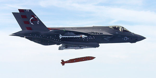
Screenshot from U.S. Navy video of a March 2016 test of an F-35 releasing the AGM-154 Joint Standoff Weapon (JSOW).
Raytheon Company and the U.S. Navy completed the final developmental test to integrate the Joint Standoff Weapon C onto the F-35 Joint Strike Fighter’s C variant, keeping the low-cost, air-to-ground missile on track for full deployment in 2019.
The JSOW glide weapon uses a GPS-inertial navigation system with an imaging infrared seeker that can identify and track targets autonomously. JSOW C weighs 1,000 pounds and is effective against high-value land targets at ranges greater than 70 nautical miles, day or night, and in adverse weather conditions.
“With JSOW C in its internal weapons bay, the Navy’s F-35C can now eliminate the toughest ground targets from significant standoff ranges,” said Mike Jarrett, vice president of Raytheon Air Warfare Systems. “JSOW’s advanced warhead and smart fuse provide fighter pilots with plenty of flexibility against hard and soft targets — plus, it has many programmable effects.”
Lockheed Martin, manufacturer of the F-35, and the F-35 Joint Program Office participated in the latest test, which took place on the Navy’s China Lake ranges in California.
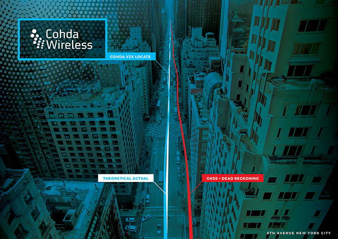
Australian company Cohda Wireless has released a vehicle positioning system to eliminate GPS black spots in “urban canyons” between high-rise buildings.
Using Cohda’s expertise in developing collision avoidance systems for mines, the vehicle-based system, V2X-Locate, can identify vehicle position to sub-meter accuracy in environments that degrade GPS accuracy, such as tunnels, underground carparks and between high-rise buildings.
As well as enhancing current connected vehicles, V2X-Locate delivers a critical component for connected autonomous vehicles (CAV), which will require uninterrupted positioning data to safely navigate on roads, the company said.
Image: Cohda Wireless
Cohda has designed V2X-Locate to enable equipped vehicles to identify their location using existing Smart City V2X (vehicle-to-everything) roadside infrastructure from any standards-based manufacturer.
Cohda Wireless Chief Technology Officer Paul Alexander said V2X-Locate was a globally unique product. “We solve the problem caused by GPS and satellite-based positioning systems not working in all use-cases,” he said.
“If you’re in a major downtown area with tall buildings, or in a tunnel or in an underground parking lot, a GPS system can fail, preventing it from delivering accurate results,” Alexander said. “As well as being inconvenient for current drivers, this is not an option as we enter the era of driverless cars. The V2X-Locate breakthrough is to position the vehicle with sub-meter accuracy by using the existing communications signals produced by V2X Smart City infrastructure deployments. The result is that V2X-Locate can eliminate positioning black spots in city centers where they are most likely to occur.”
Cohda Wireless demonstrated V2X-Locate in a 2017 trial in New York City, where it repeatedly demonstrated sub-meter accuracy while driving along Sixth Avenue, which has the tallest buildings in the Big Apple. Comparably tested GPS-based systems were as much as tens of meters off-course, at times showing cars driving through buildings.
Alexander said Cohda Wireless had designed V2X-Locate by using its experience developing collision avoidance technology for underground mines. “The hardest place to do positioning is one kilometer underground with a cubic kilometer of copper above your head,” he said.
“That’s where V2X-Locate was born,” Alexander said. “Cohda has worked in that area for several years, providing accurate positioning for vehicles where no GPS connectivity is available. We’ve now successfully migrated that technology from mine sites of the outback to the urban canyons of New York City.”
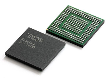
V2X_Locate uses the NXP SAF5400 single-chip modem for V2X. (Photo: NXP)
Both Cohda’s standard V2X onboard units and roadside units use the NXP RoadLINK chipset, which supports V2X-Locate’s highly accurate performance by delivering multipath channel tracking.
After a pre-release international roadshow in October last year, Cohda Wireless received strong interest in V2X-Locate from both Smart Cities and Tier 1 automotive manufacturers. To meet that demand, Cohda Wireless has released a V2X-Locate Evaluation Kit, which contains the system and four roadside unit devices, which equip prospective customers to put V2X-Locate through its paces.
Harxon Corporation is launching the single-frequency, multi-GNSS real-time-kinematic (RTK) enabled Smart Antenna TS300 series, designed for manual guidance and autosteer agriculture applications that benefit from scalable performance in positioning accuracy.
The TS300 series smart antennas are designed for manual guidance and autosteer agriculture applications. (Photo: Harxon)
The TS300 series is a multi-GNSS compatible system using GPS, GLONASS, BeiDou and Galileo for simultaneous satellite tracking to offer RTK positioning.
It is able to track any visible satellites under challenging conditions, ensuring a stable signal quality with higher precision and reliable data. Farm tractors and machines can still receive a healthy signal when the sky is partially visible or there are obstructions around the farmland.
The TS300 series features patented T-DIFF technology, providing smooth positioning and exceptional pass-to-pass accuracy. Its steady, smooth output is well suited for autosteer applications and helps the machines operate in a steady path. By reducing the impact of machine vibration during farming on complex landforms, T-DIFF technology ensures machine controlling and positioning accuracy at a centimeter level.
Powered by the latest stand-alone algorithmic technology, the TS300 series can maintain the RTK positioning accuracy for a certain period when the RTK difference link is disconnected during machine operation. It guarantees that farm machines operate effectively and accurately under poor positioning conditions.
Moreover, the TS300 series can output real-time tilt information for machines on rugged farmland. By optimizing the backend operation, it is convenient for users to improve positioning accuracy through a tilt compensation algorithm.
The data links — 3G/4G modules, external/internal radio transmission modems and Bluetooth — of the TS300 series are designed as multiple selections as required, allowing customers flexible and convenient operation in different environmental conditions.
Purpose-built for challenging environments, TS300 Series has built-in magnets to simplify mounting; fixed mounting options are also available as 5/8-inch screws and M4 screws, providing convenient and quick installation. Its IP67 ruggedized enclosure works reliably in harsh environments and is designed for professional precision agriculture applications requiring high-precision RTK positioning.
UASTrakker LLC is offering a new guidance system to enable first responders and maritime rescue units to use fully autonomous drones to help locate people lost at sea or in the wilderness.
The company will showcase the system at AUVSI Xponential, scheduled for April 30-May 4 in Denver, Colorado.
UASTrakker emergency response UAV.
The emergency RF beacon tracking system for drones is based on the company’s core patent-pending technology, which uses an internet of things (IoT) edge computer, running the company’s proprietary software and algorithms to deliver an autonomous search-and-rescue (SAR) solution to the professional end user.
UASTrakker integrated systems using an autonomous drone for locating emergency distress beacons, such as a personal locator beacon (PLB) or man overboard beacon.
The UASTrakker system is capable of locating individuals stranded in floods, lost at sea or on land and is expected to be a key component of rescue efforts in maritime rescue, as well as SAR in the wilderness.
How the system works
Trained users operate the UASTrakker-enabled drone by initiating a flight plan to locate the last known position of the target. Once in the air, the drone will scan the emergency radio frequencies used by PLB beacons in distress, and provide situational awareness to first responders using its thermal, infrared and daytime cameras.
When the target is located, the drone stores the GPS coordinates trail, and has the ability to drop lifesaving rescue supplies, or even lower a winch to a person, and rescue them to safety using a heavy lift drone.Ac
During the entire rescue, UASTrakker streams live video into the company’s cloud computing solution of the entire flight, recording the physical location of the incident in day or nighttime conditions. This enables multi-agency collaboration on SAR missions to help locate the victim.
According to the company, the UASTrakker system is compatible with many off-the-shelf drones, so it can be installed on medium-sized multi-rotors for short missions, a hybrid- electric plane for longer missions, or a heavy lifter for difficult to reach areas and rough weather.
At any time, the user can take over control of the flying of the drone, and activate features like the winch. Cellular/satellite technology offers an almost unlimited range of control.
UASTrakker ground control station.
The UASTrakker company is also developing technology for moving ground control stations, so that drones will land more easily on a ship or moving platform like a SWAT vehicle.
The company’s proprietary artificial intelligence (AI)-capable internet console is expected to provide the pilot in command a first-of-its-kind online search grid, with online tools to initiate the autonomous flight search-and-rescue procedure.
When other first responders have downloaded the UASTrakker app, they will have a collaborative map of the rescue operation, showing the drone position and the location of any emergency PLBs within range, while the drone autonomously locates and surveils them until rescuers can arrive.
“A UASTrakker customized rescue drone can be deployed in many different emergency and disaster situations to locate survivors from maritime accidents, avalanches, hikers in distress or to locate stranded people after a natural disaster like a hurricane or flood, by tracking the PLB that is activated by the person in distress,” said Shawn Holmgren, CTO of UASTrakker.
UASTrakker anticipates interest from government agencies including police, fire and rescue, and military, along with private individuals and commercial businesses.
Holmgren will introduce the system at the Association for Unmanned Vehicle Systems International (AUVSI) Xponential show, booth 3233B. The company expects to launch the UASTrakker system by the hurricane season and summer of 2018.
The first European Drone Summit will take place Oct. 15 in Frankfurt, Germany, to bring together stakeholders to discuss the future of drones in Europe. The summit is sponsored by UAV DACH e.V. and Interaerial Solutions of Intergeo.
In addition to being a smart, up-and-coming technology, commercial drones are also an integral part of the digitalisation of business and society. The EU member states have agreed to introduce legislation regulating the operation of unmanned aircraft in Europe that takes into account both economic potential and safety requirements.
The programme will be put together by UAV DACH experts and will explore legal aspects, technological issues and various application areas. Legislators, industry representatives and user groups will meet on the eve of Europe’s largest trade fair for commercial drones.
The following experts will speak (with more to be named later):
Peter van Blyenburgh, UVSI
Max Scheck, Vereinigung Cockpit
Jules Kneepkens, EASA a.D.
Martin Brandenburg, DJI
Andreas Lamprecht, AIRMAP
Jörg Seebach, DeDrone
UAV DACH is an association for commercial unmanned aviation in Europe. It represents the interests of 175+ corporate members from research, manufacturing and application located in Germany, Austria, Switzerland, Italy, Spain and the Netherlands.
The Interaerial Solutions part of Intergeo is the largest commercial drone trade fair in Europe. It takes place Oct. 16-18, also in Frankfurt.
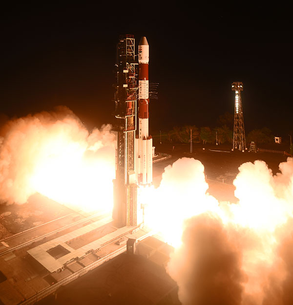
A replacement satellite for NavIC, India’s navigation constellation, was successfully launched April 11 from Satish Dhawan Space Centre SHAR, Sriharikota.
In its 43rd flight, the India Space Research Organization’s (ISRO’s) Polar Satellite Launch Vehicle PSLV-C41 propelled the 1,425-kilogram IRNSS-1I Navigation Satellite into orbit.
PSLV-C41 lifted off at 0404 hrs (4:04 a.m.) IST, as planned, from the spaceport’s First Launch Pad. After a flight lasting about 19 minutes, the vehicle achieved a sub-geosynchronous transfer orbit with a perigee (nearest point to Earth) of 281.5 km and an apogee of 20,730 km inclined at an angle of 19.2 degrees to the equator, following which IRNSS-1I separated from PSLV.
After separation, the solar panels of IRNSS-1I were deployed automatically. ISRO’s Master Control Facility (MCF) at Hassan, Karnataka, took over the control of the satellite. In the coming days, orbit maneuvers will be performed from MCF to position the satellite at 55 degrees East longitude in the planned geosynchronous orbit with an inclination of 29 degrees to the equator.
IRNSS-1I is the latest member of the Navigation with Indian Constellation (NavIC) system. NavIC, also known as Indian Regional Navigation Satellite System (IRNSS), is an independent regional navigation satellite system designed to provide position information in the Indian region and 1500 kilometers around the Indian mainland.
A number of ground facilities responsible for IRNSS satellite ranging and monitoring, generation and transmission of navigation parameters, satellite control and network timing have been established in many locations across the country as part of NavIC.
Spirent Communications plc is working with the European Commission’s Joint Research Centre (JRC) to help implement the eCall system, which is required in new cars sold in Europe starting in April.
Experts from the JRC have been working with Spirent GNSS test equipment during the European GNSS Agency (GSA) eCall test campaign. The campaign aims to pre-test eCall in-vehicle modules and evaluate their compatibility with the positioning services provided by Galileo and the European Geostationary Navigation Overlay Service (EGNOS) in accordance with the test procedures established by the regulation.
As the eCall initiative goes live this month, the GSA launched a test initiative to support eCall device manufacturers in their preparation for type approval. In safety-critical situations, eCall must be as accurate as possible, so defining and conducting proper test procedures is imperative.
Spirent is cooperating with the JRC to develop its own eCall test solution. “Working with JRC enabled us to develop better tests to verify that eCall devices are working properly,” said Steve Hickling, product director for Spirent’s positioning business.
When a collision occurs, an eCall-equipped car automatically calls the nearest emergency centre. Even if no passenger is able to speak – such as because of injuries — a “minimum set of data” is sent, which includes the exact location of the crash site. eCall is expected to significantly reduce emergency service response times, leading to lives saved and injuries reduced.
The JRC used a Spirent GSS9000 simulator to assess eCall devices’s capability to support the reception and processing of the Galileo and EGNOS signals. Using feedback from the JRC, Spirent has developed an eCall Test Suite for its automation solution, PT TestBench.
Tested with various eCall devices, the eCall Test Suite is available for eCall device manufacturers and include, among others, positioning accuracy, time to first fix, GNSS receiver sensitivity and reacquisition performance.
FoXTEN software product gives soldiers access to real-time intelligence data in the field.
Raytheon Company has been awarded a U.S. Army contract to demonstrate the company’s commercially available mobile intelligence platform that will allow soldiers to quickly collect and access information on the battlefield.
Raytheon’s commercial laptop-based platform, called the FoXTEN, may be considered as a future mobile component of the Army’s Distributed Common Ground System (DCGS).
FoXTEN provides mapping functions in both MIL-STD-2525B and MIL-STD-2525C symbology.
DCGS is an intelligence, surveillance and reconnaissance system that enables deployed soldiers to collect, process and display intelligence information from a variety of sources and sensors. The Army is upgrading its existing DCGS system with a series of new components and capabilities, including the mobile platform.
“Our soldiers need real-time access to intelligence and surveillance data, and FoXTEN is designed to get that information to and from the most remote edges of the battlefield,” said Todd Probert, vice president of mission support and modernization at Raytheon Intelligence, Information and Services. “We’ll be bringing our deep experience integrating the best commercial software into a system our soldiers can trust to keep them constantly aware of threats and give them the advantage they need to win on any battlefield.”
Under the contract awarded by the U.S. Army Contracting Command, Raytheon will demonstrate the company’s FoXTEN software product, which can be loaded onto a commercially procured laptop and easily deployed and used by soldiers operating in the field.
FoXTEN quickly connects warfighters to intelligence from various sources, giving them the real-time information they need to make mission decisions across all battle domains. FoXTEN, when loaded onto a laptop, is lightweight, requires little power and can operate at low-transmission speeds.
“Our system is intuitive, easy to use and only takes eight hours of training compared to the current system,” said Probert. “It’s also completely open, allowing the Army to integrate new capabilities from any developer. The system is designed from the ground up to be easily upgraded so our soldiers always have the best technology and intelligence in their hands.”
The Army will conduct a series of operational tests of the FoXTEN software over the next year before making a final procurement decision.