Open access to information of geographic places and spatial relationships provides an essential part of the analytical processing of spatial data. Access to connected geospatial programs allows for improvement in teaching and understanding science, technology, engineering and mathematics.
Emerging Trends in Open Source Geographic Information Systems provides emerging research on the applications of free and open software in GIS in various fields of study. While highlighting topics such as data warehousing, hydrological modeling and software packages, the book explores the assessment and techniques of open software functionality and interfaces.
It will serve as a resource for professionals, researchers, academicians, and students seeking current research on the different types and uses of data and data analysis in GIS.
Topics covered include:
Data Warehousing
Geo-Crowdsourcing
Geospatial Databases
Geospatial Facilities
Hydrological Modeling
Multimedia Codes
Search Mechanisms
Software Packages
Spatial Data Mining
270 pages, ISBN13: 9781522550396/ISBN10: 1522550399, publisher: IGI Global
Polaris Wireless, a provider of high-accuracy, software-based wireless location solutions, has signed a multi-year, multi-phase contract for delivery of a wireless location solution that complies with the Federal Communications Commission’s (FCC) most recent E911 wireless location accuracy mandate with The Alaska Wireless Network, a company wholly owned by GCI Communication Corp (GCI).
The first phase of the contract extension includes the Polaris Wireless Evolved Serving Mobile Location Center (E-SMLC) with hybrid location software for LTE networks that complies with FCC-mandated indoor location requirements. Subsequent phases include delivery of additional location technologies and hybrid algorithms as cellular networks and mobile devices continue to evolve and become more capable.
Polaris Wireless describes its hybrid location solution as inherently future proof to take advantage of improvements in cellular networks and mobile devices.
“We are excited to continue working with GCI in providing our software-based location solutions,” said Amir Sattar, vice president of global operations for Polaris Wireless. “Polaris takes great pride in GCI trusting us to provide GCI E9-1-1 callers with the highest level of location accuracy when and where they need it most.”
“We have enjoyed a long-term relationship with Polaris Wireless delivering wireless E9-1-1 location solutions for many years,” said Gene Strid, chief technology officer of GCI. “As the carriers must now locate E9-1-1 callers in challenging indoor environments, we are happy to leverage Polaris Wireless’s technological innovation and commitment in delivering high-accuracy, software-based location solutions.”
“Polaris Wireless E-SMLC product leverages all available and emerging technology to deliver the best location position accuracy we can for our subscribers’ emergency calls,” said John Myhre, vice president of wireless technology at GCI.
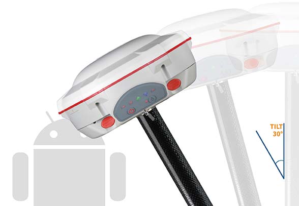
ComNav Technology has introduced the T300 Plus GNSS receiver, an upgrade to its T300 receiver.
Designed for demanding surveying tasks, the rugged T300 Plus GNSS features full-constellation tracking capability, tilt compensation, 4G/Wi-Fi connection, 8-GB internal memory and an easy survey workflow with Android-based Survey Master Software. It is designed to make collecting accurate data easy and fast, whether done by a beginner or experienced professional surveyor.
As an upgrade of the T300, SinoGNSS T300 Plus combines a GNSS board, Bluetooth and adjustable TX/RX UHF, Wi-Fi and 4G modem into one rugged device. Its built-in 4G modem ensures the T300 Plus works with all kinds of CORS worldwide. Moreover, T300 Plus built-in tilt sensor supports maximum 30-degree pole tilt and keeps the compensation accuracy within 3 centimeters, and the user can check the electronic bubble on the controller for fast surveys in the field.
With two hot-swappable batteries, the T300 Plus helps to extend working hours, the company said. The battery LEDs flash when the battery runs low; they can be replaced or charged directly while in the T300 Plus through an external power connection. Its consumer-grade battery design is compatible with the Canon LP-E6, which can be purchased in retail stores.
https://youtu.be/HddhJXF8D3Y
ComNav Technology also provides the T300 Plus GNSS surveying system with the Android-based R500 data collector and Survey Master software, providing for powerful and straightforward survey workflow in the field.
The T300 Plus is now available through ComNav Technology authorized local distributors or directly through ComNav Technology.
EGNOS V3 will offer improved and secure Civil Aviation Safety of Life services for the next decade over Europe. The program will ensure a full continuity of service and will be the first operational SBAS using both GPS and Galileo.
Airbus has been selected by the European Space Agency (ESA) as the prime contractor to develop EGNOS V3, the next generation of the European Satellite Based Augmentation System (SBAS) planned to provide the civil aviation community with advanced safety-of-life services and new services to maritime and land users.
Developed by ESA on behalf of the European Commission and the European GNSS Agency (GSA), EGNOS V3 (European Geostationary Navigation Overlay Service) will provide augmented operational safety-of-life services over Europe that improve the accuracy and availability of user positioning services from existing GNSS (Galileo and GPS).
EGNOS also provides crucial integrity messages to EGNOS users with alerts within a few seconds in case of system degradation, consolidating EGNOS’ position as one of the leading edge GNSS systems in the future.
Besides improved safety-of-life services, EGNOS V3 will improve robustness against increasing security risk, in particular cyber-security risks.
EGNOS V3 will ensure a full continuity of service for the next decade and will be the first operational SBAS implementing the dual-frequency and multi-constellation world standard, with both GPS and Galileo, replacing EGNOS V2 which has been in operation since 2011.
“This programme is strategic for Airbus to strengthen our position in the Navigation field. The signature of this contract is the result of more than 5 years of intense team work and investment,” said Nicolas Chamussy, head of Space Systems at Airbus. “With our consortium, we bring a large pool of resources and experience in Europe covering the successful development of critical and secure ground segment. I am confident that we will make EGNOS V3 a success story.”
As prime contractor, Airbus will be leading a consortium with partners from France, Germany, Spain and Switzerland. Airbus will be responsible for the development, integration, deployment and preparation of EGNOS V3 operations, the overall performance of the system and the Central Processing Facility, which is the heart of the real-time navigation algorithms.
During the 6.5-year contract, around 100 people and 20 subcontractors will work on delivering the EGNOS V3 system. In 2023, the single-frequency version will be available to replace the current operational version and, 18 months later, the final version in dual frequency will be delivered.
EGNOS is composed of a large network of about 50 ground stations deployed over Europe, Africa and North America, two master control centers near Rome and Madrid, and a System Operation Support Centre in Toulouse. EGNOS will also use geostationary satellite navigation payloads.
The European Space Agency (ESA) held its annual Navigation Days on Jan. 26. ESA navigation specialists met with guests from the European Commission, European Global Navigation Satellite Systems Agency and European space companies at ESA’s technical centre in the Netherlands.
With Europe’s Galileo satellite navigation system only one launch away from full global coverage, representatives of the European space industry gathered at ESA’s centre in the Netherlands to discuss the transition towards the future Galileo Second Generation.
Galileo Initial Services began on Dec. 15, 2016, while the constellation in orbit has grown to 22 satellites. An Ariane 5 launch later this year of another quartet will bring the constellation to the point of completion with 24 satellites, plus two orbital spares.
A steady stream of orbital spares, ready to replace satellites reaching the end of their operational lives, is necessary to ensure Galileo continues operating seamlessly. A further 12 satellites were therefore ordered from industry in June 2017.
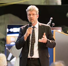
Paul Verhoef, director of the Galileo Programme addresses the audience at ESA’s annual Navigation Days, held Jan. 26. (Photo: ESA)
Looking further ahead, with the aim of keeping Galileo services as a permanent part of the European and global landscape, a replacement set of Galileo satellites will be required post-2020, serving as transition to a future generation.
The Galileo Second Generation is foreseen to offer improved performance and added features. This is why the European Commission has decided on a Transition Programme, with the European Space Agency (ESA) in charge of its technical definition and implementation.
Together with the European Commission and the European Global Navigation Satellite System Agency, the agency invited leading European space companies to its technical centre in Noordwijk for Navigation Days, held Jan. 26, to discuss Galileo’s future and present short-term plans in relation to this transition programme.
Having started with the ESA European Global Navigation Satellite System Evolutions Programme (EGEP), the system and technology development of Galileo Second Generation is being supported through the EU’s GNSS and Horizon 2020 HSNAV Programmes, with ESA being delegated its technical definition and management of its related implementation.
Eleven Phase-B contracts were signed at the meeting for the Design Phase for both the Galileo Second Generation and the Transition Programme, complementing the more than 50 technology contracts signed in 2017 to prepare for Galileo’s future.
In recent years, innovations have been analysed and predevelopments performed in various technology fields (system, ground, space, receiver technologies) in order to assess their suitability for future Galileo activities, while ensuring backward compatibility and continuity of Galileo Services.
In the next eight months, all major public and private stakeholders will be involved in the detailed assessment of the different evolution scenarios and associated technologies, in order to come to decisions on the Transition Programme baseline for the evolution towards Galileo Second Generation.
TomTom has launched TomTom AutoStream, an innovative map delivery service for autonomous driving and advanced driver assistance systems. The first partners to use the technology — Baidu and Zenuity — were unveiled at the 2018 Consumer Electronics Show.
TomTom AutoStream enables vehicles to build a horizon for the road ahead by streaming the latest map data from the TomTom cloud. By ensuring that the map used to power advanced driving functions is always the latest, TomTom AutoStream enhances driver comfort and safety.
“The launch of TomTom AutoStream is a game-changer for OEMs and technology companies that are working on the future of driving,” said Willem Strijbosch, TomTom’s head of autonomous driving. “TomTom AutoStream allows vehicles to access the latest, most up-to-date TomTom map data for their driving automation functions.”
TomTom AutoStream is designed in a flexible way, allowing customers to customize the map data stream based on criteria such as sensor configuration and horizon length. It can stream a wide variety of map data including ADAS attributes such as gradient and curvature, and the TomTom HD Map with RoadDNA. This flexibility allows customers to use AutoStream to power a wide range of driving automation functions.
Strijbosch continued, “Our early investment in the TomTom advanced map-making platform means that we can continue to deliver revolutionary innovations like TomTom AutoStream. With TomTom AutoStream we can significantly simplify and shorten the development time for our customers, accelerating the future of driving.”
TomTom AutoStream ensures that the TomTom map data used to power advanced driving functions is the latest, most accurate available, enabling a safer and more comfortable experience.
“With AutoStream TomTom is offering an innovative map delivery system targeted at automated driving,” said Roger C. Lanctot, director, Automotive Connected Mobility for Strategy Analytics. “The development is targeted at helping automakers bring ADAS and autonomous driving functions to market faster.”
TomTom AutoStream will be available for production usage in 2018.
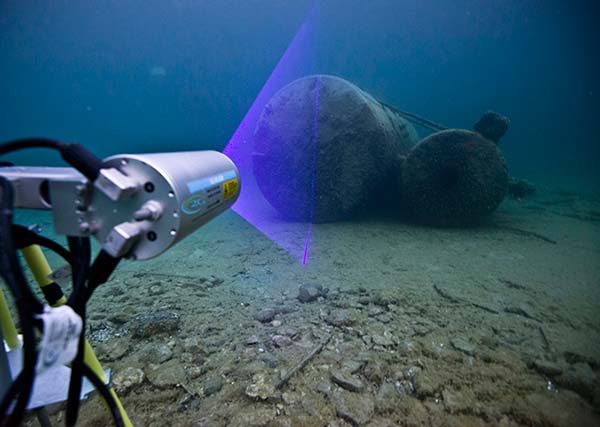
The first of four ULS-500 PRO laser scanning systems from 2G Robotics has been shipped to Kongsberg Maritime for integration into the Norwegian Defence Materiel Agency’s (NDMA) newly purchased Hugin autonomous underwater vehicles (AUVs).
The acquisition signifies the Royal Norwegian Navy’s transition to autonomous systems for mine countermeasures. During operations, Hugin AUVs will be used to complete surveys of subsea environments focused specifically on locating and identifying mines.
The Hugin systems enable users to conduct fast and efficient operations with zero surface visibility while additionally improving safety conditions by allowing personnel to remain outside the minefield. In peacetime, the AUVs contribute to hydrographic operations.
The ULS-500 PRO dynamic underwater laser scanner system will contribute to the detection, classification and assessment of mines. 2G’s system acquires data in real time and provides users with 3D models of targets and environments accurate to the sub-centimeter.
The complete laser scanning system also includes the 2G Observer, an ultra-sensitive stills camera able to capture images at 12 fps, and the 2G Nova, an LED panel designed specifically for AUV integration providing almost 1,000,000 lumens.
Handheld Group has launched the Nautiz X9, an ultra-rugged enterprise handheld built for fieldwork in challenging outdoor or industrial environments. It can be used as a mobile computer, data collector or field controller, the company said.
The Nautiz X9 offers:
A quad-core processor and easy-to-use Android 7 (Nougat) OS.
GPS/GLONASS capabilities standard.
Optional high-quality, high-speed 2D imager.
Dual cameras including 13-megapixel rear-facing with autofocus and flash, and 2-megapixel front-facing.
4G/LTE Android phone functionality.
Google GMS for Google Maps navigation and Play Store app access.
A sunlight-readable 5-inch capacitive display with multi-touch sensitivity.
IP67 ruggedness rating for waterproof, dust-tight performance.
The Nautiz 9 is MIL-STD 810G tested for drops, vibrations, humidity, extreme temperatures and varying altitudes.It has a fast 1.3-GHz processor with 2-GB RAM and 16-GB Flash. The 4800-mAh battery will run for a full shift, even with heavy use.
“Adding the Nautiz X9 to our family of products reflects our commitment to bringing truly rugged field devices to market,” said Johan Hed, Handheld Group director of product management. “The Nautiz X9 also extends our wide Android offerings, which have been in increasingly high demand. GMS certification is an extra feature not always included in enterprise devices, but it has proved to be invaluable for our customers, giving them access to the full suite of Google applications. The reliability and toughness of the Nautiz X9 will bring great value to field users worldwide.”
Applanix, a Trimble Company, has introduced its Autonomy Development Platform to provide automakers, truck makers and Tier 1 vehicle suppliers the hardware, software, engineering and integration services they need to accelerate their development programs for on-road and off-road autonomous vehicles.
By combining customized integration and engineering services along with Applanix’ GNSS-inertial positioning technologies, the Autonomy Development Platform advances driverless vehicle development projects at every stage of development and commercialization.
“With the introduction of our Autonomy Development Platform, Applanix now offers on-road and off-road vehicle manufacturers the tools and engineering expertise necessary to support and augment their driverless vehicle development programs,” said Louis Nastro, director of Land Products at Applanix.
“The platform delivers a navigation solution that is fully customizable and includes integration and engineering services, field-tested hardware and proprietary software for highly accurate positioning,” continued Nastro. “The navigation solution is capable of working with all sensors, including multiple cameras, lidar, radar and ultrasonic sensors, and with all vehicle types at all stages in the development and commercialization cycle.
“The Applanix technology enables highly accurate assessments of the full 360-degree environment around a vehicle to produce a robust representation, including static and dynamic objects, critical for successful vehicle autonomy.”
“Applanix has been committed to meeting the needs of autonomous vehicle manufacturers for more than a decade, going back to our success at the DARPA Challenges. In addition, our expertise in autonomous technologies is part of an extensive portfolio of Trimble solutions for automation and vehicle autonomy, which began more than three decades ago,” said Steve Woolven, president of Applanix. “Our refined positioning algorithms and expertise with sensor fusion and mobile robotic technologies enable us to provide a development platform that delivers the required performance and reliability for manufacturers to develop and produce self-driving vehicles for all environments and tasks.”
The Applanix Autonomy Development Platform is available now through the Applanix worldwide sales channel.
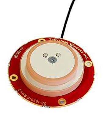
Tallysman, a manufacturer of high-performance GNSS antennas and related products, is offering a new light-weight compact GPS L1/L2 + GLONASS G1/G2 antenna, available either as an OEM (TW1829) antenna or in a housed version (TW8829).
The antenna is designed for unmanned aerial vehicle use because of its low aerodynamic profile and very light weight. The TW1829 weighs 37 grams and is 48mm (d) x 12.2mm (h). The TW8829 weighs 52 grams and is 47.3mm (d) x 18.3mm (h).
The antennas employ Tallysman’s Accutenna technology, which has proven its ability to provide high-level rejection of multipath signals, a phase linear response and tight phase centre variations (PCV).
Additionally, the antenna has pre-filters to prevent the saturation of the front end LNA by strong near frequency and harmonic signals.
The antenna is available with a choice of connectors and custom cable lengths. Additionally, Tallysman can custom tune the TW1829 for the customers’ enclosure to ensure optimal performance.
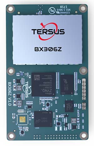
Tersus GNSS Inc. has launched the BX306Z GNSS RTK board, which has powerful flexibility and compatibility to meet the needs of original equipment manufacturers (OEMs) and system integrators, according to the company.
As a new member of the BX-series GNSS OEM boards, BX306Z is a cost-efficient GNSS real-time kinematic (RTK) board for positioning and raw measurement output.
The board is a compact, multi-GNSS (GPS L1/L2, GLONASS G1/G2, BeiDou B1/B2) RTK module with centimeter-level accurate positioning capability.
Features
The BX306Z is able to integrate with autopilots and inertial navigation units.
Log and command is compatible with major GNSS boards.
With flexible interfaces, the pin-to-pin design is compatible with Trimble BD970.
All of these features help manufacturers reduce their application cost and lead time to market.
With George Antheil, Hedy Lamarr invented spread-sprectrum communications in 1942.
What do a 1930’s Hollywood star and the inventor of spread-spectrum communications have in common? They are one and the same.
The new documentary Bombshell highlights not just the acting career of Hedy Lamarr, but her contributions as an inventor. With George Antheil, Lamarr invented spread-sprectrum communications in 1942 and, specifically, the frequency-hopping version.
Explains Innovation editor Richard Langley, “When a signal’s frequency is quickly shifted in a seemingly random way among a large number of frequencies, the signal can become buried in the background noise and difficult to detect.
“However, when received, the signal can be recovered by changing the tuned frequency in exactly the same manner as was used for the transmission, thereby lifting the signal out of the noise, allowing it to be heard. Enemy eavesdroppers might not even know a signal was present and wouldn’t be able to decode it anyway unless they knew the frequency-shift sequence.
“Another way to create a spread-spectrum signal is to spread it using a direct pseudorandom code sequence, and this is what GPS and the other GNSS do.”
Lamarr and Antheil’s radio system answered a different need — to guide torpedoes to their targets during World War II. The team was granted U.S. Patent No. 2,292,387 for a “Secret Communication System.”
Their system “employs a pair of synchronous records…which change the tuning of the transmitting and receiving apparatus from time to time, so that without knowledge of the records an enemy would be unable to determine at what frequency a controlling impulse would be sent.”
Bombshell, a Zeitgeist Films release, opened in theaters Nov. 24.
 A new book on open-source geospatial information systems (GIS) will be published in May.