Europe’s next two Galileo navigation satellites have touched down in Europe’s Spaceport in French Guiana ahead of the launch of a quartet by Ariane 5 at the end of this year (scheduled for Dec. 12).
Galileos 19 and 20 left Luxembourg Airport on a Boeing 747 cargo jet on the morning of Sept. 18, arriving at Cayenne — Félix Eboué Airport in French Guiana that evening.
Safely cocooned within protective air-conditioned containers, the pair were offloaded and driven to the cleanroom environment of the preparation building within the space centre.
A Galileo satellite in its protective container is unloaded from its cargo plane after landing in French Guiana Sept. 18. (Photo: ESA)
This building will remain their home as preparations for their launch proceeds, with the next two Galileos due to join them later this month.
The satellites join the first elements of their customised Ariane 5 at the centre — including its cryogenic main stage and half-shell payload fairing — which were delivered by ship the week before.
Galileo is Europe’s own satellite navigation system, providing an array of positioning, navigation and timing services to Europe and the world.
A further eight Galileo “Batch 3” satellites were ordered last June, to supplement the 26 built so far.
A Galileo satellite is driven to the Guiana Space Centre following its arrival on Sept. 18. (Photo: ESA)
With 18 satellites now in orbit, Galileo began initial services on Dec. 15, 2016, the first step towards full operations.
Further launches will continue to build the constellation, which will gradually improve performance and availability worldwide.
The Kenyan government will be using SimActive’s Correlator3D to map mining activities. The software will be used to generate orthomosaics, contour lines and digital terrain models of fluorspar mines in the Kerio valley in Kenya.
The Directorate of Resource Surveys & Remote Sensing (DRSRS) under the Ministry of Mining in Kenya chose the software.
“The DRSRS provides the Ministry of Mining with spatial information, processing hundreds of images to visualize settlements affected by mining activities to advise the Government of Kenya on compensation plans,” said Charles Situma, deputy director of the project. “SimActive’s availability of experts internally allows us to receive tailored solutions to our requests, further expediting our processing.”
“We are proud to have Kenya as another of our many government users,” said Dr Philippe Simard, President of SimActive. “Correlator3D provides the diverse tools and processing power required for intensive mining applications.”
General Motors Co.’s (GM) self-driving unit, Cruise Automation, has more than doubled the size of its test fleet of robot cars in California during the past three months, a GM spokesman told Reuters.
The unit is testing vehicles in San Francisco as part of its effort to develop software capable of navigating congested and often chaotic urban environments.
GM has reported more run-ins between its self-driving cars and human-operated vehicles and bicycles. Its vehicles were involved in six minor crashes in September, all of which were caused by the other vehicle.
In the past three months, the Cruise unit has increased the number of vehicles registered for testing on California streets to 100 from the previous 30 to 40.
Lidar acquisition. GM announced Oct. 9 that it hasacquired lidar technology company Strobe. Strobe’s engineering talent joins GM’s Cruise Automation team to define and develop next-generation lidar solutions for self-driving vehicles.
In September, Cruise Automation revealed the world’s first mass-producible car designed with the redundancy and safety requirements necessary to operate without a driver. The vehicle will join Cruise’s testing fleets in San Francisco, metropolitan Phoenix and Detroit.
Lidar uses light to create high-resolution images that provide a more accurate view of the world than cameras or radar alone. As self-driving technology continues to evolve, lidar’s accuracy will play a critical role in its deployment.
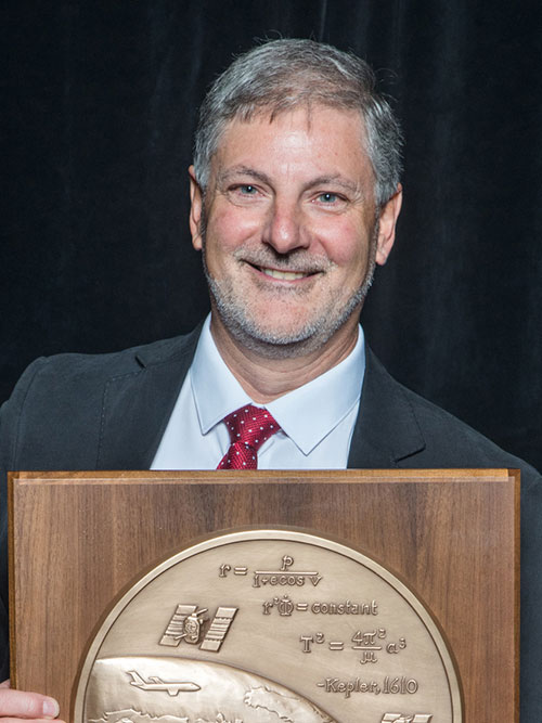
The Institute of Navigation’s (ION) Satellite Division presented Professor Terry Moore with its Johannes Kepler Award for his outstanding contributions to the development of satellite navigation through a sustained and distinguished professional career devoted to research and teaching.
Moore received the award Sept. 29 at the ION GNSS+ Conference in Portland, Ore. Moore is a member of the GPS World Editorial Advisory Board.
Terry Moore has more than 30 years of research experience in surveying, positioning and navigation technologies, and is a consultant and advisor to European and U.K. government organizations and industry.
He has taken a leading role in national and European initiatives aimed at integrating academic research and teaching activities in GNSS and interacting closely with industry.
Moore is credited with extensive work on the introduction and implementation of WGS 84 as the standard reference systems for air and marine navigation, as well as the development of standard software tools for coordinate transformations and map projections used extensively through the aviation industry.
Additionally, he is known for the development of GRINGO software that pioneered the use of raw GPS code and carrier phase data from low cost Garmin receivers. His work has also includes the pioneering of novel methods and algorithms for GPS orbit relaxation; which led to reduced dynamic GPS-based orbit determination for LEO spacecraft, with a real-time implementation.
Moore is the Director of the Nottingham Geospatial Institute (NGI) at the University of Nottingham where he has responsibility for all of NGI’s research and teaching. He is also the founding Director of GRACE, the GNSS Research and Applications Centre of Excellence, which was jointly funded by the University of Nottingham and East Midlands Development Agency, and targets knowledge transfer between the NGI and business. Additionally, he leads the university-wide Aerospace and Transport Technology Research Priority Area.
Moore has supervised numerous research projects funded by industry, research councils, the European Space Agency and the European Commission, and has supervised more than 30 Ph.D. students.
Moore is involved in the volunteer activities of numerous international professional and scientific bodies. He is currently a Royal Institute of Navigation (RIN) Vice-President (now also President Elect) and a member of their Technical Committee, while simultaneously serving on the ION Council as a Technical Representative and as a co-chair of the ION’s Satellite Division’s Technical Peer Review Committee.
He has served on the ION’s Satellite Division Executive Committee on numerous occasions and is a past ION GNSS+ program and general chair.
Moore is a Fellow of both the Institute of Navigation and the Royal Institute of Navigation (RIN). He is also a Fellow of the Chartered Institution of Civil Engineering Surveyors, a Fellow of the Royal Astronomical Society and an Associate Fellow of the Remote Sensing and Photogrammetry Society. In 1999 and 2008 he was awarded the RIN Richey Medal (best paper in the RIN Journal of Navigation), in 2013 was awarded the RIN Harold Spencer-Jones Gold Medal (outstanding contributions to navigation), and in 2016 the RIN J.E.D. Williams Medal (contributions to the RIN).
He holds a BSc degree in Civil Engineering and Ph.D. degree in Space Geodesy, both from the University of Nottingham, where he was promoted to the U.K.’s first Chair of Satellite Navigation in 2001.
The Johannes Kepler Award recognizes and honors an individual for sustained and significant contributions to the development of satellite navigation. It is the highest honor bestowed by the ION’s Satellite Division.
Sokkia has unveiled a new radio modem designed to offer advanced radio connectivity with GNSS receivers. The R4S-BT UHF radio provides an external option for use with the Sokkia GCX receiver line.
The UHF multichannel radio modem has a tuning range of up to 70 MHz. Additionally, the radio features an IP67 certified housing with internal batteries that is designed to be easy to carry with versatile mounting options.
“The R4S-BT makes the GCX GNSS receiver into an even more scalable and modular solution,” said Jason Hallett, vice president of global product management at Sokkia. “It is perfect in situations without a network connection or when long-range Bluetooth technology is not enough on its own. Survey and mapping professionals can simply add on this external UHF and extend the range between the base and rover.”
Connectivity options include wireless data transfer and USB connections.
Trimble is offering three new GNSS-inertial systems for direct georeferencing on unmanned aerial vehicles (UAVs): the Trimble APX-15-EI UAV, Trimble APX-18 UAV and Trimble APX-20 UAV.
Direct georeferencing with the systems allows the location of image elements collected by lidar and hyperspectral sensors to be accurately computed without extensive networks of ground control points, reducing costs while maintaining accuracy to produce maps.
The APX products use state-of-the-art low noise, multi-frequency Trimble Maxwell GNSS technology, and track all current satellite signals including GPS L1/L2/L2C/L5 and GLONASS L1/L2, QZSS, BeiDou, IRNSS and Galileo, supporting SBAS, RTK and Trimble CenterPoint RTX positioning modes.
The APX-15-EI UAV features dual inertial measurement units (IMU); one embedded onto the GNSS-inertial board that is mounted on the UAV airframe with the GNSS antenna, and one that is mounted on an external sensor contained in a gimballed mount.
With this feature, the APX-15-EI UAV can compute two sets of orientations — the UAV airframe and the gimballed mount — enabling automatic, precise positioning of the sensor without requiring an external interface to the gimballed mount or autopilot.
The APX-20 GNSS-inertial board by Applanix.
The APX-18 UAV is a single-board GNSS-inertial solution that supports two-antenna heading for the highest accuracy in low-speed multi-rotor survey applications such as building facade scanning. Measuring 10 x 6 centimeters and weighing 62 grams, the APX-18 UAV uses on-board inertial sensors calibrated with the Applanix SmartCal software compensation technology for superior performance in a small, compact form for UAVs.
To meet the higher accuracy demands driven by the allowance of higher altitude, beyond visual line of sight (BVLOS) UAV flights and the introduction of higher resolution, larger format imaging sensors, Trimble has developed the APX-20 UAV.
Also featuring dual IMUs for automatic gimballed mount support, the APX-20 UAV uses a new, MEMS-based lightweight external IMU with unparalleled performance. With a total weight of less than 425 grams, the APX-20 UAV provides high performance without sacrificing flight time.
“We are very pleased to announce these new additions to our portfolio of products for Direct Georeferencing on UAVs,” said Joe Hutton, director of inertial technology and airborne products at Applanix, a Trimble Company. “We have listened to our customers and worked very hard to come up with solutions that meet their needs, both from a technical and cost perspective.”
All APX products include the Applanix POSPac UAV post-processing software for generation of high-accuracy carrier-phase differential GNSS-inertial position and orientation for highest accuracy map products.
POSPac UAV supports single GNSS base-station processing with automatic coordinate survey using Trimble CenterPoint RTX, multi-single base station processing, and Applanix SmartBase Virtual Reference Station processing (optional), as well as the Trimble CenterPoint RTX post-processing trajectory generation available as a subscription.
Trimble made several product announcements at Intergeo 2017, the world’s largest conference on geodesy, geoinformatics and land management.
The new solutions include:
Trimble C5 and C3 mechanical total stations
The Trimble C5 and Trimble C3 mechanical total stations are the only mechanical total stations in the industry to come standard with autofocus technology. With premium-quality Nikon optics, the new C-Series reduces time in the field with improved measuring speed and the longest EDM range of any Trimble conventional instrument.
Trimble T10
Trimble T10 10-inch tablet
The T10 is a high-performance, large-screen device suitable for a variety of survey and GIS applications that provides the processing power of a laptop computer in tablet form to enhance efficiencies for geospatial users in the field. (Now you only need one device for collecting and processing data while out on the job.)
Trimble Business Center and Trimble Clarity
The newest version of Trimble Business Center introduces enhancements and new capabilities to process high-accuracy GNSS data, create CAD deliverables, and leverage full data traceability through the project lifecycle.
Trimble Business Center version 4.0 introduced new capabilities to process high-accuracy GNSS data with confidence, create CAD deliverables and leverage full data traceability throughout the project lifecycle. Surveyors can obtain greater field flexibility without compromising quality via the addition of a new GNSS processing engine that increases solution reliability for baselines exceeding several hundred kilometers/miles.
Version 4.0 also extends the survey CAD capabilities including text editing, ortho drafting and coordinate geometry (COGO) tools that provide a comprehensive set of tools for rapidly producing end-client deliverables. A new History Log feature captures all data changes throughout the project, from GNSS processing to CAD deliverable, providing greater workflow transparency, data traceability and ultimate confidence.
Clarity by Trimble.
Trimble Clarity is a new cloud-based application within the Trimble Connect collaboration platform that enables surveyors to easily share rich project data and imagery, allowing clients — even those who have no experience with engineering software — to view and use data in a web browser.
The result is improved workflow efficiencies and greater situational awareness that enable more informed decision-making.
Users can perform 3D measurements, annotate objects and quickly collaborate with project stakeholders. Multidiscipline teams now have access to a single source of geospatial data that enables more accurate and informed decisions, increases productivity, minimizes rework and reduces project delays.
Trimble Clarity reduces the time required for large file transfers and eliminates the need for specialized software knowledge to get value from laser scanning deliverables.
Trimble eCognition.
Trimble eCognition
The latest version of eCognition adds 3D point cloud analytics and deep learning technology so you can perform a broader range of geospatial analysis with a greater level of control.
Trimble GEDO IMS System
This new addition to Trimble’s track survey and scanning rail portfolio is lightweight, flexible and fast, combining an inertial measurement unit (IMU) with scanning and geodetic sensors for surveying railway lines and documenting assets along the track.
The trolley system is lightweight, flexible and fast. It combines an IMU with scanning and geodetic sensors for surveying railway lines and documenting assets along the track.
The GEDO IMS System provides highly accurate as-built survey documentation of the track and 3D point clouds for asset data collection along the track. The trolley system’s lightweight design is ideal for single-crew operation and on projects near active railway lines. GEDO IMS Field Software and the GEDO Office Software Suite enable smooth data flow between the field and the office. GEDO Scan Office provides enhanced processing for asset data collection and clearance applications.
The basic Trimble GEDO IMS System consists of the Trimble GEDO CE 2.0 Trolley System, Trimble GEDO IMU Unit, Trimble Tablet PC and the Trimble GEDO IMS Field and GEDO Office Software. For mapping applications it can be combined with the Trimble TX6 and TX8 laser scanners.
Topcon Positioning Group is updating its data-collection software for the SmoothRide resurfacing workflow solution. RD-M1 Collect 2.0 includes updates designed to facilitate and optimize mapping of road conditions.
Topcon is exhibiting at Intergeo 2017 in Hall 2.1, Booth A2.008, and in Hall FG, Booth 005. Intergeo takes place Sept. 26-28 in Berlin, Germany.
The improvements feature an improved interface that is designed to simplify setup and automatically detect the position of the wheel sensor during data collection, the company said.
An RD-M1 Collect 2.0 graphical interface status bar indicates the optimum speed for collecting road information based on project requirements, helping the software deliver the best results for the project.
Memos is a new feature designed to allow operators to create balloons with messages on the map while collecting data that also can be made visible in the processing software, enabling specific site conditions to be noted for future reference.
The new Manage Runs feature is designed to enable operation without necessitating Windows explorer to be open.
Large buttons make using a tablet or laptop with touchscreen easy. Operators can copy data collections to a USB drive, delete them from the hard drive, and add or remove them from the manager.
The RD-M1 Collect 2.0 new Plan Route feature allows for the import of kml files of predetermined routes, designed to ensure nothing is missed on the drive.
Using the new map downloader, operators can have all map details visible while collecting data, without an internet connection. Overlapping locations can be managed by creating areas where predefined overlaps are required for the project.
Leica Geosystems has released the Leica GS18 T, a fast GNSS RTK rover, as well as the latest versions of Leica Captivate field software and Leica Infinity office software.
Leica made the announcement at Intergeo 2017, held Sept. 26-28 in Berlin, Germany.
The announcement expands the Leica Captivate Experience. With the addition of calibration-free GNSS and various upgrades to the Captivate field software and Infinity office software, users continue the immersive experience with self-learning GNSS and engaging, intuitive software interfaces.
“In my business, speed is the name of the game,” said Manny Sangha, owner of Sangha Geomatics & Land Survey Inc. in Vanderhoof, Canada. ” With my GS16, I’ve been able to reduce time spent on every project. I can only see this getting faster and improving efficiency with the GS18. No longer having to level the pole nor calibrate the system, this is a real value for me and a game-changer in the industry.”
Calibration-free tilt compensating GNSS
According to Leica Geosystems, the GS18 T is the a calibration-free tilt compensating GNSS solution immune to magnetic disturbances.
GNSS measurements can be taken from any position on site, saving users up to 20 percent of time in the field over conventional surveying practices, because they no longer need to hold the pole vertical to level the bubble.
The GS18 T uses precise inertial measuring units (IMUs) and not a compass, so that users can measure with a tilted pole close to buildings, underneath cars and close to metallic objects.
With integrated quality assurance, the GS18 T records exactly how the pole was leveled during the measurement. The GS18 T then stores the values, ensuring measurement traceability and complete quality reporting.
Software updates
Fully supporting the GS18 T, Leica Captivate v3.0 field software and Leica Infinity v2.4 office software now offer users a more immersive means of control on site and at the desk.
Captivate now allows configuration of the GS18 T for all measuring and staking applications and the visualization of tilt compensated measurements. Measured data can be directly imported into Infinity or exported into a variety of formats suitable for CAD packages.
Within Infinity, users can visualise the measured data, including the creation of reports providing full traceability and quality assurance for themselves and their clients.
Hemisphere GNSS (hall 2.1 / stand C2.008) has released the Crescent Vector H220, the next offering in a line of new and refreshed, low-power, high-precision, positioning and heading OEM boards.
The announcement was made at the Intergeo trade show, being held this week in Berlin, Germany. Hemisphere is showcasing the board at its booth in Hall 2.1, Stand C2.008.
The Multi-GNSS H220 by Hemisphere GNSS.
The single-frequency, multi-GNSS H220 provides added benefits over the prior generation H200 with a more robust positioning and heading solution and integrates Atlas GNSS Global Correction Service.
Designed with a new hardware platform, it offers true scalability with centimeter-level accuracy in either single-frequency mode or Atlas-capable mode that supports fast RTK initialization times over long distances, the company said.
The H220 offers fast accuracy heading of better than 0.30 degrees at 0.5-meter antenna separation in ideal conditions and aiding gyroscope and tilt sensors for temporary GNSS outages. The 109 x 71 millimeter module with 34-pin header is a drop-in upgrade for existing designs using the H200.
The latest technology platform enables simultaneous tracking of all L1 constellations including GPS, GLONASS, BeiDou, Galileo and QZSS, making it robust and reliable. The updated power management system efficiently governs the processor, memory and ASIC, making it ideal for multiple integration applications.
The H220 offers flexible and reliable connectivity by supporting Serial, USB and CAN for ease-of-use and integration. Optional output rates of up to 50 Hz are also supported.
Advanced Features. The H220 offers integrated L-band support for Atlas corrections providing global sub-meter position accuracy while Hemisphere’s Tracer technology helps maintain position during correction signal outages.
Integrators, developers and OEMs can maximize their performance by including the H220 in their systems for antenna pointing, marine survey, machine control, and any application where high-accuracy positioning and heading is required.
Harxon has released the multi-constellation D-Helix Antenna at the 2017 Intergeo trade show, held Sept. 26-28 in Berlin, Germany. The Harxon booth is located at Hall 4.1, Stand C4.013.
The industrial, innovative D-Helix Antenna is capable of superior tracking of signals from GPS L1/L2 L-Band, GLONASS L1/L2, BDS B1/B2/B3 and Galileo. The innovative quadrifilar helix antenna design of low wind-resistance is ideal for UAV positioning and navigation.
The increased antenna gain and beamwidth ensure a better signal receiving performance of satellite at low elevation angle. The low noise figure enhanced transmission interference reduction and improve the signal quality.
The D-Helix antenna can be used in UAV patrol, UAV plant protection, unmanned patrol robot and unmanned surveying vessel. According to the company, it provides the centimeter-level positioning accuracy for a stable flightpath and prevents air turbulence, to enable a reliable positioning, height setting and heading information.
The antenna has been recognized by many industry experts and received inquiries from potential partners at the first launch day.
Other showcased products from the Harxon GNSS family include its survey antenna, rover radio, frequency hopping modules, smart antenna and H-RTK, are also appropriate for the fields of surveying and mapping, precision agriculture and UAVs.
GeoMax, professional surveying and construction product provider, has announced the X-PAD Office Fusion, the all-in-one office software combining data from multiple sensors into one easy-to-use interface.
X-PAD Office Fusion software manages, combines and processes data from GNSS receivers, total stations, laser scanners and other sensors in one single environment whether from GeoMax or any other provider in the market. There is no need to export the data from one program to another, and X-PAD also offers all CAD features.
The new software handles a multitude of different types of data: measurements, coordinates, drawings and point clouds. Large quantities of data can be managed in the fastest way with maximum accuracy. The software automatically detects the common points between the point clouds and performs a first rough alignment.
The Bundle Adjustment feature performs the final and accurate alignment in order to reduce errors. Personalized reports are then created with little effort.
“The choice to use X-PAD Office Fusion is due precisely to its ability to handle different data and process: traditional topographic data with both GPS and laser scanners processes,” said Federico Ferrari, Department of Architecture, University of Ferrara. “X-PAD Office Fusion has made it easy to integrate captured data with GeoMax Zoom 300 and those acquired through photo modeling to get a complete 3D model of inaccessible areas, including surveys with traditional laser scanners.
“The ability to extract drawings directly from X-Fusion PAD without using other CAD products, including through the bubble view, makes it an extremely fast and practical product, even for those who do not have specific surveying skills, such as archaeologists like us. A simple and intelligent interface and a great 3D data management engine make X-PAD Office Fusion a truly unique product and easy-to-use and easy-to-teach, enabling us to give more time for critical analysis than using the software itself.”