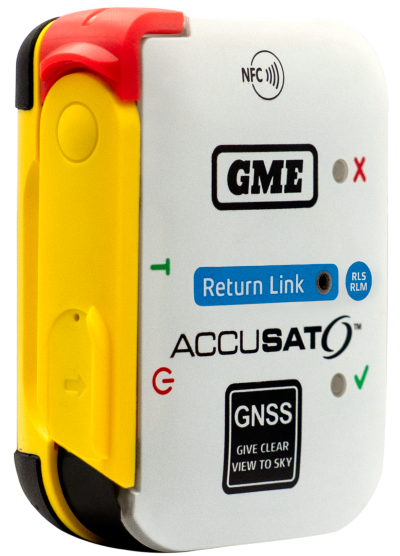
Austtralian company GME is offering its first emergency beacon with Return Link Service (RLS). RLS confirms the distress signal has reached a rescue coordination centre (RCC), providing critical reassurance in an emergency.
The MT620GR personal locator beacon (PLB), with integrated RLS and a mobile app, is a compact safety companion for outdoor and marine adventure enthusiasts.
Enhanced with GNSS for precise global positioning and a 121.5 MHz homing signal, it ensures efficient SAR operations. It is approved for worldwide Cospas-Sarsat operation.
The companion mobile app monitors the beacon’s operational status. With a seven-year battery life and a six-year warranty, it offers dependable performance and peace of mind, according to GME.
India’s Directorate General of Civil Aviation (DGCA) has made it mandatory for pilots and air traffic controllers to report GPS interference within 10 minutes of it occurring, reports Hindustan Times. The new protocol follows incidents at the New Delhi airport reported on Nov. 5.
Incidents that should be reported include position anomalies, navigation errors, loss of GPS integrity, and spoofed location data, states a three-page circular issued on Nov. 10.
The real-time reporting should include data such as aircraft type and registration, airline or operator name, date and time of spoofing occurrence, flight sector and route, coordinates or area of occurrence, type of interference and aircraft equipment affected.
Grab Singapore has launched a pilot program that uses high-accuracy lane-level GPS positioning to enhance the navigation experience for its driver and delivery partners in Singapore.
The pilot — rolled out in collaboration with Oppo, Qualcomm Technologies and Swift Navigation — also marks the first deployment of high-accuracy GPS positioning on mobile phones and app integration in Southeast Asia, delivering unprecedented outdoor location accuracy for Grab’s partners.
Grab is a leading app in Southeast Asia, operating across the deliveries, mobility and digital financial services sectors. It enables location-based services in more than 800 cities in eight Southeast Asian countries: Cambodia, Indonesia, Malaysia, Myanmar, the Philippines, Singapore, Thailand and Vietnam.
As part of its ongoing efforts to enhance the GrabMaps navigation experience, Grab continually explores new technologies to help improve accuracy and reliability for its driver and delivery partners. In dense urban environments such as Singapore’s high-rise buildings, multi-level roads, and underground networks can degrade standard GPS accuracy above 20 m, complicating navigation between pick-ups and drop-offs, and reducing ETA accuracy.
By bringing together leading technology partners to create an advanced navigation system, Grab’s driver- and delivery-partners can now pinpoint their location with higher accuracy, improving navigation efficiency in GPS-challenging environments, while enabling smoother pick-ups and reduced cancellations.
The pilot taps on the individual expertise of the following partners:
OPPO, which provides its Find N5 foldable phone with dual-frequency GNSS capable of supporting the latest positioning technology.
Qualcomm Technologies, which activates the Meter-Level Positioning for Mobile featured in the Snapdragon 8 Elite Mobile Platform that powers the OPPO Find N5, enabling real-time GPS correction signals.
Swift Navigation, which provides its cloud-based Skylark Precise Positioning Service that uses advanced atmospheric modeling to correct GPS signal errors and deliver 10x greater positioning accuracy. Skylark is built on top of a network of ground reference stations operated in partnership with network operators around the world, including Singapore Land Authority (SLA). SLA operates the Singapore Satellite Positioning Reference Network (SiReNT) which provides Skylark with accurate GNSS data to enable precise positioning for last mile ride hailing and logistics in Singapore.
Together, these technologies power the pilot, with OPPO’s Find N5 foldable phone, Qualcomm Technologies’s Snapdragon 8 Elite Mobile Platform, and Swift Navigation’s Skylark working in concert to deliver precision navigation experiences.
With results of the pilot, Grab plans to extend the enhanced positioning capability to its proprietary Karta devices in the near future — broadening access to precise navigation technology and ensuring more driver and delivery partners can benefit from it over time.
The European Navigation Conference (ENC) series is widely acknowledged as the most important annual event in Europe bringing together the full positioning, navigation and timing (PNT) community.
ENC 2026 will take place in Vienna, Austria, from April 28-30, 2026. This follows very successful ENCs in the last few years.
ENC2026 offers:
a technical program across three days with up to four parallel sessions,
daily keynote addresses in plenary, bringing the community together,
a friendly and collaborative atmosphere, with opportunities to meet exhibitors and fellow delegates, including informally over drinks and dinner as part of the conference social programme,
an environment to gain insights, grow social networks and foster new collaborations.
The ENC-series is a collaboration across the European Group of Institutes of Navigation (EUGIN), with the Austrian Institute of Navigation (OVN) leading ENC 2026 at the Austria Center Vienna.
The conference will highlight the latest advancements in PNT. The broad technical program will include all related aspects of technology, science, systems and applications.
ENC-series is open to everyone from industry, academia, government and user segments. To learn more, visit the ENC 2026 website.
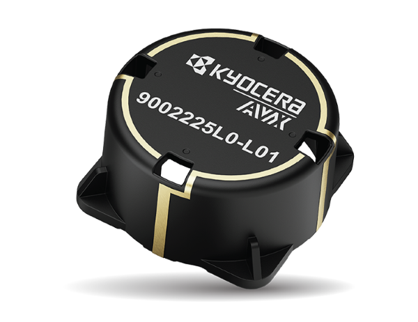
KYOCERA AVX has launched an LDS cap antenna and evaluation board optimized for Iridium satellite IoT applications and designated as Iridium Qualified Antenna products for Iridium Certus 9704 modules.
The antenna was developed to provide Iridium with an embedded antenna optimized for low-Earth-orbit (LEO) satellites used to provide seamless connectivity and data exchange for IoT devices anywhere in the world. The new LDS cap antenna developed for Iridium outperforms the ceramic patch antennas traditionally used in these applications.
Manufactured using laser direct structuring (LDS) technology — an efficient process for creating complex, compact, lightweight, wide-bandwidth, and high-gain 3D antenna designs on myriad substrates — the new LDS cap antenna is smaller and lighter than ceramic patch antennas and exhibits excellent right-hand circular polarization (RHCP) and superior gain from zenith to horizon, which maximizes satellite visibility and reliability and is especially beneficial for improving the connectivity of LEO satellites at low elevation angles. It also exhibits wider bandwidth and higher radiation efficiency than patch antennas.
The new KYOCERA AVX LDS cap antenna developed for Iridium supports GNSS (1,559–1,610MHz) and Iridium (1,616–1626.5MHz) frequencies with ~2dBi peak gain and 60% efficiency, and delivers reliable performance in challenging environments, including over metal. It’s rated for 4W power handling, 50Ω feed point impedance, and operating temperatures extending from -40° to +85°C. It’s also proven to withstand exposure to high temperatures, high humidity, and salt spray, compliant with the latest RoHS and REACH directives, and packaged and shipped on tape and reel for automated assembly with reflow soldering.
The on-board antenna has a small, lightweight form factor with a unique design that measures 35.7 mm in diameter and 17.98 mm high, weighs 6.85g, facilitates easy SMT assembly, and allows device manufacturers to locate components on its underside, saving space on the main PCB board.
The new antenna is expressly designed for satellite connectivity, targeted for satellite IoT applications, and well-suited for applications including telematics, asset tracking, remote monitoring, smart farming and smart city applications. Earlier this year, it was shortlisted for Electronic Specifier’s Electronics Excellence Awards in the passive product category.
Quectel Wireless Solutions is partnering with Swift Navigation to deliver Quectel’s Real-Time Kinematic (RTK) Correction Solution, which enables cost-effective, centimeter-level positioning accuracy for a new generation of IoT applications.
In January, the companies announced integration of Swift’s Skylark Precise Positioning Service with Quectel’s high-precision GNSS modules.
The collaboration allows Quectel to simplify the complexities of high-precision GNSS by bundling its RTK modules and antennas with Swift’s Skylark Precise Positioning Service, offering equipment manufacturers a streamlined, end-to-end solution for RTK adoption and deployment.
Partnering with Swift enables Quectel to tailor solutions for specific applications, helping equipment manufacturers simplify the complexities of RTK adoption and deployment. The Quectel RTK Correction Solution is designed to support a wide range of mass-market applications, including robotics, automotive, micro-mobility, precision agriculture, surveying, and mining.
India’s aviation regulator, the Directorate General of Civil Aviation (DGCA), is collecting data on GPS interference and spoofing to have a better understanding of the situation, reports several news outlets in the country. The urge to collect data comes after the Delhi airport experienced issues in the past few days.
Following a circular issued by the Directorate General of Civil Aviation in 2023, instances of GPS interference/spoofing have been reported since November 2023.
Recently, several airlines have faced GPS spoofing at the New Delhi airport, with at least eight such instances on Nov. 5, said an unnamed DGCA official. The interference instances were noticed in domestic and international flights.
Generally, interference issues are reported in border areas, rather than at Indira Gandhi International Airport, the country’s busiest. Daily flight movements have increased to more than 1,500 following an airport terminal upgrade completed in October.
As many as 465 GPS interference and spoofing incidents were reported in the border region, mostly in the Amritsar and Jammu areas, between November 2023 and February 2025.
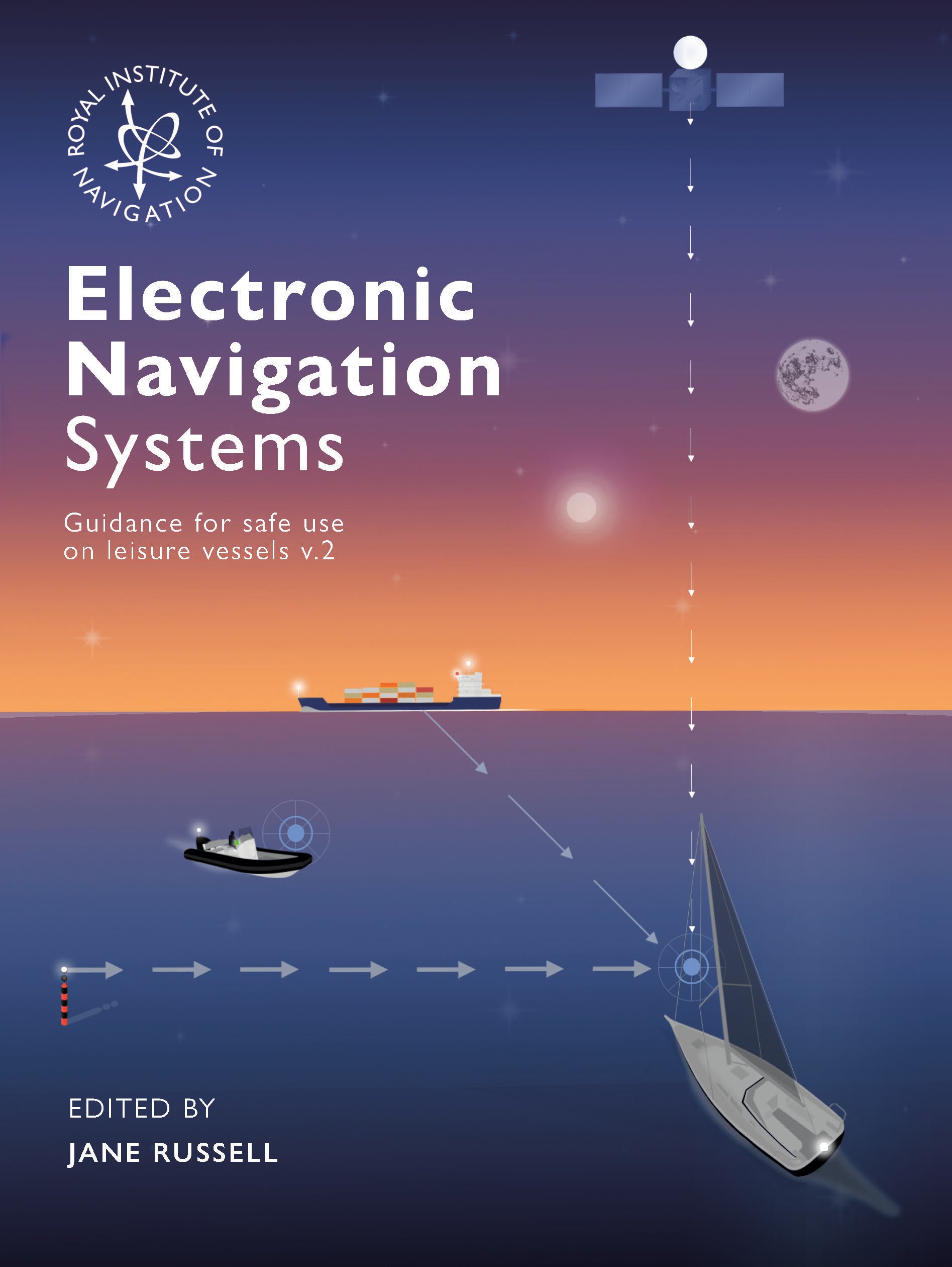
The Royal Institute of Navigation Small Craft Group has released Version 2 of a free navigation guide for small and leisure craft.
“Electronic Navigation Systems: Guidance for safe use on leisure vessels” is offered as a free digital download and as a hard copy for purchase from Bookharbour. The RIN website is asking those who want to download a copy to answer a single survey question.
Updates in the new version reflect developments in GNSS, electronic charts and their display systems, as well as feedback from readers, including a new sub-section on Astronavigation (Chapter 5).
Guidance includes
safe use of electronic navigation and associated systems on leisure vessels
“keys to safety” in many operational situations
advantages and drawbacks of different systems and approaches.
Version 1 of the “Electronic Navigation Systems” booklet is still available as a free download.
Feedback for Manufacturers
As a result of work on the first edition, published in 2020, the small craft group has compiled commendations for improvements to electronic navigation systems for leisure vessels. The improvements could be made by manufacturers and official bodies to assist the safety of leisure vessels through better design or regulation. “These recommendations did not sit comfortably in the booklet so can be viewed here,” the Small Craft Group announced.
As a result, the Pleasure Vessel Navigation Systems Working Group (PVNSWG) was set up, reporting to the UK Safety of Navigation Committee (UKSON). The Working Group’s remit is to
Propose minimum standards of functionality expected from electronic leisure charts and display systems.
Explore and consider if a means by which electronic charts and systems displaying them, which meet these standards, could be recognized by the Maritime and Coastguard Agency (MCA) for use on pleasure vessels.
Discuss with electronic chart and display system equipment manufacturers the most efficient approach to deliver proposed minimum standards and achieve recognition.
The challenge of repairing GNSS stations in Bangladesh is recounted in a Nov. 6 article by Mike Steckler, a researcher with Columbia Climate School.
Steckler has been conducting research in the country for 25 years. He previously installed a continuously operating reference station (CORS) network in the southern region of the country.
Data from the network has enabled study of the tectonic motions of the Earth leading up to earthquakes. It also revealed the sinking of the land in the world’s largest delta to less than 1 mm/y.
“I still find that amazing compared to the days before GNSS became routine,” he writes. “I’ve been at sea where the crew had to use sextants to estimate our position to within 10 miles.”
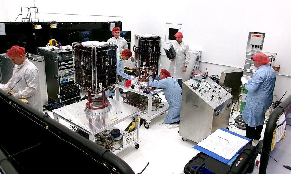
Of 16 stations running in the country, only three (green) were transmitting data back to the U.S. “I have returned here once again with others to get them working again and add three new stations (white),” Steckler writes.
Steckler was joined by a team from Dhaka University to visit the sites, make repairs and install new equipment.
Map of Bangladesh showing the locations of Steckler’s GNSS sites and regions he is visiting. The green circles are working systems, the red ones need repair, and the white ones are new. The pink circles are monuments with no active system. (Image: Mike Steckler)
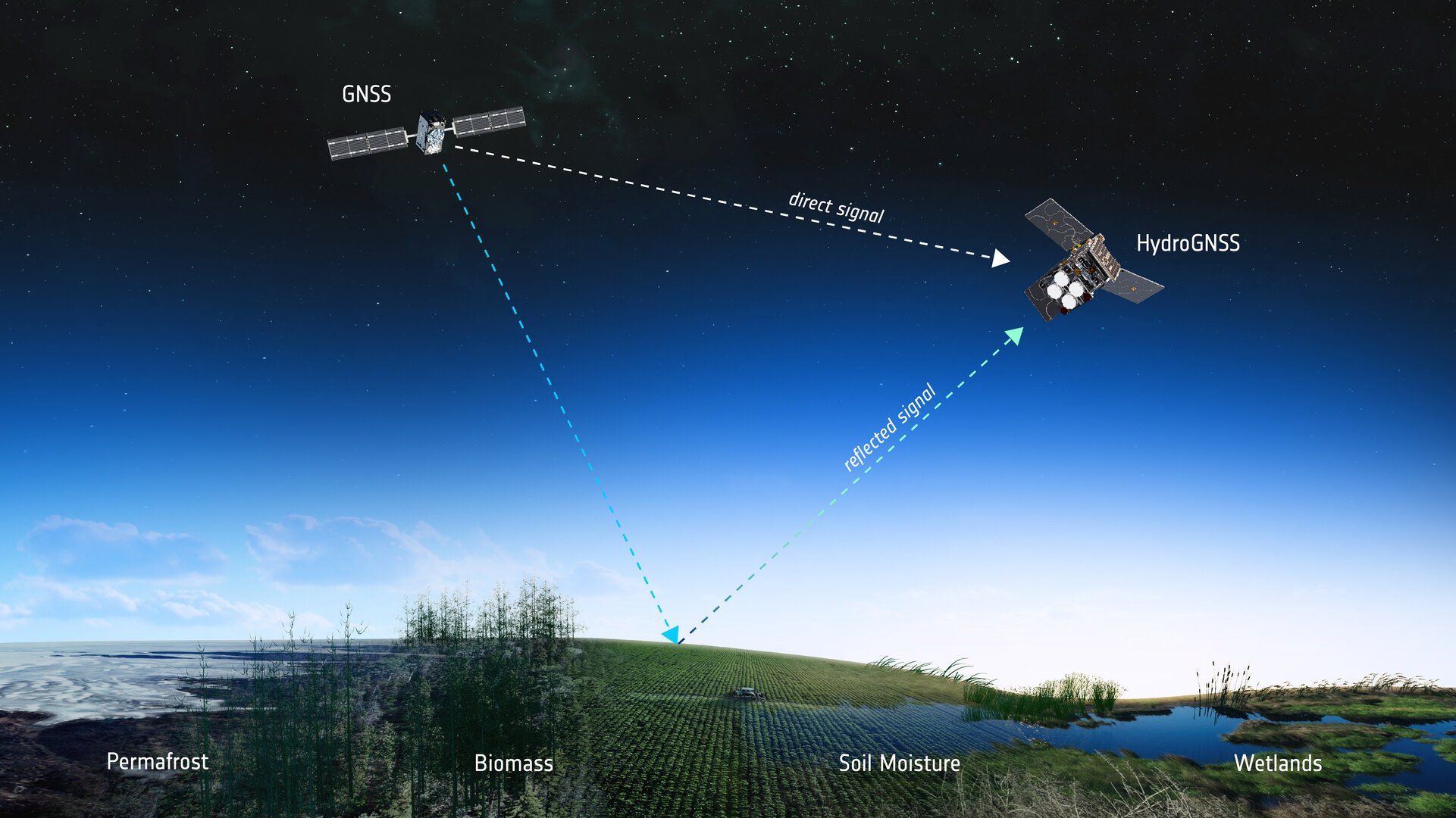
Two European Space Agency (ESA) microsatellites will soon be launched to study climate variables linked to water using GNSS reflectometry. The twin HydroGNSS satellites arrived at Vandenberg Space Force Base in California at the end of September, from where they will be launched later this month.
The HydroGNSS twins are the European Space Agency’s first Scout venture, part of the agency’s Earth Observation FutureEO programme. Scout missions are designed to deliver cutting-edge science quickly and affordably, complementing ESA’s larger Earth Explorer missions.
The identical microsatellites will launch from Vandenberg aboard a SpaceX Falcon 9 rocket, sharing their Transporter-15 ride into orbit with several other small satellites.
Since their arrival, the HydroGNSS satellites have undergone a series of final checks — including testing, propellant loading, battery charging and integration with their launch adapter. Both satellites are now ready for closing of the rocket fairing.
Once in orbit, the two satellites will travel 180 degrees apart around Earth to maximize coverage.
The mission focuses on four crucial variables, all recognized as “essential climate variables” or closely related to them: soil moisture, freeze–thaw state over permafrost, inundation and above-ground biomass. These data are vital for improving our understanding of Earth’s water cycle, including wetlands, permafrost dynamics and forest carbon storage. The data will aid in agricultural planning, flood prediction, and others areas.
HydroGNSS satellites will use GNSS reflectometry to measure key hydrological climate variables, including soil moisture, freeze–thaw state over permafrost, inundation and wetlands, and above-ground biomass. (Image: ESA)
Navigation satellites such as GPS and Galileo transmit L-band microwave signals that change when reflected off Earth’s surface. HydroGNSS will compare these reflected signals with the direct GNSS signals to extract valuable information about geophysical parameters related to the water cycle.
New Space missions. Inspired by the principles of New Space, the Scout programme emphasises agility and innovation — using small satellites to miniaturise proven technologies or demonstrate entirely new ways of observing Earth.
Each Scout mission must move from kick-off to launch within just three years and under a budget of €35 million, covering everything from satellite development to in-orbit commissioning. The resulting data are provided as a service to the scientific community and ESA, helping accelerate our understanding of the planet.
Ag Leader has launched RightPath, a passive implement steering solution, to alleviate issues in precision agriculture resulting from drift.
Putting the right seed in the right location with the right fertilizer is critical for farmers, and has led to the wide adoption of technology such as autosteer. However, if the pass-to-pass accuracy isn’t perfect at planting, the crop is vulnerable to damage in subsequent passes, which drags down yield.
Trailed implements are known for drifting off the guidance line even when farmers use autosteer. The result is inaccurate placement of inputs and inconsistent guess rows. This is an issue because accuracy drives yield.
RightPath is designed to operate seamlessly through Ag Leader’s InCommand Go displays. (Image: Ag Leader)
A passive implement steering solution, RightPath keeps implements centered on the guidance line. This not only ensures precise input placement but also increases operational efficiency throughout the growing season, while minimizing crop damage, yield loss, and operator challenges.
RightPath enables farmers to:
place the implement — and therefore rows and inputs — in the right place.
plant seed accurately relative to a previous operation such as strip-till or NH3.
achieve consistent guess rows in all conditions including curves and uneven terrain.
re-use the same guidance line in the next field activity.
reduce stress and fatigue.
RightPath is designed to operate seamlessly through Ag Leader’s InCommand Go displays. In addition, RightPath is compatible with both SteerCommand Z2 and SteadySteer, Ag Leader’s integrated and assisted steering solutions.
While both the vehicle and implement require Ag Leader’s GPS 7500 to utilize RightPath, only the vehicle needs to be equipped with TerraStar-C, TerraStar-L or RTK. This gives an operator the flexibility to choose the right GPS correction for different operational needs.
RightPath is available now through a single purchase unlock, with no recurring subscription fee.
BDStar Navigation subsidiary TruePoint has introduced the TruePoint.CM network real-time kinematic (NRTK) service across Europe, the latest in BDStar’s expansion into international high-precision positioning markets.
Supporting all major GNSS and QZSS, the service is designed to improve signal reliability in complex European environments. TruePoint.CM is built on the company’s chip-cloud integration architecture and works with both BDStar’s Unicore and third-party GNSS hardware through standards-based interfaces.
The service provides wide-area coverage throughout Europe, the company said, offering centimeter-level accuracy with fast convergence times. Before launch, TruePoint conducted extensive validation testing in more than 40 cities across 12 European countries, including more than 300,000 kilometres of dynamic field trials.
The platform uses an adaptive data protocol to reduce bandwidth consumption by up to 70% while maintaining full positioning accuracy, a feature aimed at helping customers reduce operational data costs. Remote diagnostics and over-the-air firmware updates are incorporated to support more efficient device management in the field.
TruePoint.CM operates on a fully redundant cloud infrastructure spanning data sources, data centers and service-delivery interfaces. The system is designed to ensure continuous uptime, backed by a stated service availability of 99.9%.
At launch, the company reported that it has already secured commercial adoption in the European robotic lawn mower market, with additional opportunities expected in autonomous robotics, UAVs, precision agriculture, automotive and consumer IoT.