Author: Tracy Cozzens

  • Swift Navigation and Asensing partner on automotive-grade GNSS for industrial autonomy

    Swift Navigation and Asensing partner on automotive-grade GNSS for industrial autonomy

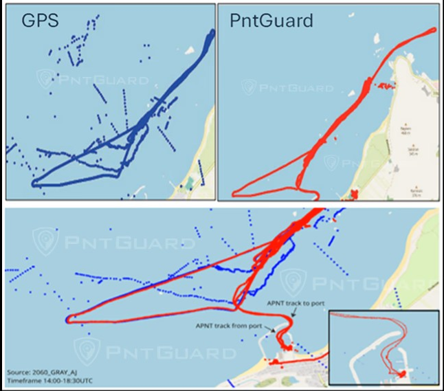
    Swift Navigation and Asensing have announced full compatibility between the Asensing NAV3120 high-precision GNSS positioning module and Swift’s Skylark Precise Positioning Service. Skylark is a cloud-based service that improves the accuracy of GNSS from several meters to a few centimeters.

    The widespread deployment of connected and autonomous IoT systems — including smart delivery robots, UAVs, precision agriculture and logistics — demands reliable, centimeter-level positioning that performs consistently across diverse environments and at scale.

    Swift’s Skylark Nx RTK, the highest precision variant of Skylark, leverages a proprietary atmospheric model to deliver continuous 1-2 cm accuracy across vast geographic areas, including Western Europe. The carrier-grade network eliminates the need for developers to manage base stations or switch between multiple correction providers, simplifying the deployment of high-precision outdoor robots at scale.

    The seamless interoperability between Skylark Nx RTK and Asensing’s NAV3120 module provides customers with a highly reliable, centimeter-accurate solution packaged in a compact, automotive-qualified hardware module. Joint testing demonstrated this high performance, with the solution achieving a sustained 1.7 cm horizontal position error at 95% confidence during a 24-hour period, which significantly accelerates time-to-market for applications requiring the highest level of positioning integrity.

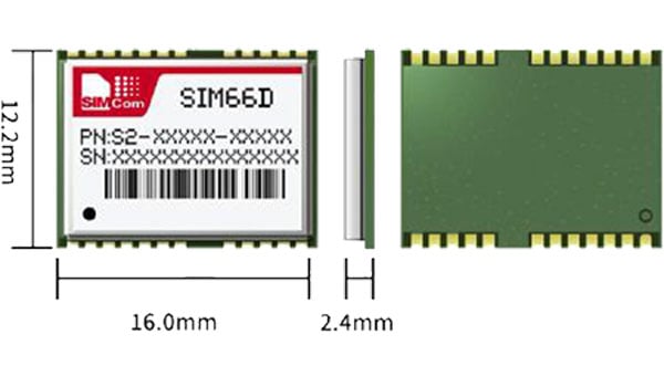
    The NAV3120 is full-constellation and quad-frequency signal reception module engineered for demanding applications. Features include:

    • Automotive-grade. Complies with AEC-Q100 standards for integrated circuits used in automotive applications.
    • Extreme operating range. Sustains temperatures from -40°C to +105°C.
    • Compact design. Small size and standard 17 x 22 x 3.1 mm footprint, weighing only 2g.
    • Efficient power. Low power consumption of just 0.4W.

    The integrated solution is available now for use for autonomous mobile robots, UAVs, fleet management, advanced handhelds and wearables, and precision agriculture.

  • Teledyne completes acquisition of Saab’s TransponderTech

    Teledyne completes acquisition of Saab’s TransponderTech

    The new FLIR TransponderTech unit will advance GNSS, AIS and VDES technologies for maritime, aerospace and defense markets.

    Teledyne Technologies has completed its acquisition of the TransponderTech business from Saab AB. The acquired company, now operating as Teledyne FLIR TransponderTech AB, will become part of Teledyne’s Raymarine, FLIR Marine, ChartWorld and Teledyne CARIS group of maritime technology brands.

    Based outside of Linköping, Sweden, the company will market its products and solutions as FLIR TransponderTech. The brand will continue to focus on delivering GNSS, Automatic Identification System (AIS) and VHF Data Exchange System (VDES) technologies.

    Going forward, FLIR TransponderTech will be well positioned to continue to pioneer maritime communication solutions for civil and military customers in shipping, marine traffic, airborne and space segments.

  • Raytheon UK awarded UK Space Agency contract for satellite tracking

    Raytheon UK awarded UK Space Agency contract for satellite tracking

    Raytheon UK, part of RTX’s Raytheon business, has been awarded a contract to provide orbital analysts in support of the UK’s Space Domain Awareness mission.

    Under the contract, the UK Space Agency will gain access to Raytheon UK’s NORSSTrack software, which enhances orbital analysis and operational responsiveness by mapping and tracking satellites, monitoring potential collisions and debris, assessing re-entries and providing critical data for decision-making.

    The analysts will be based at a National Space Operations Centre facility at Royal Air Force Base High Wycombe.

    As highlighted in the UK’s Strategic Defence Review, space domain awareness is central to protecting critical space assets and strengthening resilience across government, defense and industry. It is considered a vital national capability, ensuring the UK can operate safely, securely and confidently in an increasingly contested space environment.

  • PntGuard protects against GNSS spoofing and jamming at sea

    PntGuard protects against GNSS spoofing and jamming at sea

    Tschudi Shipping CompanyNAL Research and SGM Technology AS have launched PntGuard, a maritime-security solution that provides pinpoint situational awareness. It supports navigational integrity at a time when GNSS signals can no longer be taken for granted.

    standalone navigational aid independent of all other bridge systems, PntGuard delivers instant alerts the moment a vessel’s position is falsified, providing true position data when other bridge systems are compromised.

    The electronic warfare problem

    Malicious disruption of GNSS signals is increasing for the maritime industry. Attacks can originate from land-based systems, hostile or “dark-fleet” vessels, or even occur opportunistically in congested sea lanes – often without vessel crews ever realising their position has been manipulated.

    Critical scenarios include:

    • Collisions and groundings (especially in low visibility, at night, and in dense traffic zones with risk to life, assets, and the environment)
    • Unintended or manipulated entry into restricted waters
    • Claims of sanctions evasion / calling at ports in sanctioned states
    • ort delays / disruptions to cargo logistics including deviations causing delays, increased fuel consumption, and emissions.
    • Charter disputes and insurance challenges when a vessel appears to have breached compliance boundaries

    Enabled by the Iridium low-Earth orbit (LEO) satellite network, PntGuard receives a secured PNT signal about 1,000 times more powerful than GNSS and is resilient to jamming and spoofing of those systems. The solution complements a vessel’s navigation feed with accurate situational awareness and immediately alerts the crew to manipulation or interruption, its makers say.

    PntGuard comprises two compact components – an above-deck unit (receiver) that connects to the Iridium PNT service and a below-deck unit (bridge display) that shows both the falsified GPS track and the vessel’s true position on a nautical chart in real time.

    Shore offices can also receive an accurate record of a vessel’s true position at any time – proof that can be shared with charterers or insurers to defend against claims based on false data and safeguarding both revenue and reputation.

    About the PntGuard partnership

    PntGuard has been developed through a collaboration between cross-industry partners Tschudi Shipping Company, NAL Research Corporation and SGM Technology, combining expertise from resilient satellite services, maritime technology and vessel operations.

    Tschudi Shipping Company is a fifth-generation, Norwegian family-owned shipping and logistics group with more than 100 years of history of owning and managing ships. Focusing on client value through tailored solutions, strong partnerships, digital innovation, Tschudi’s core values are commitment, respect, and proactivity.

    NAL Research Corporation, based in Virginia, USA, is a leader in Assured Positioning, Navigation and Timing (APNT) technologies, providing secure, resilient communications and tracking solutions for defence, government and enterprise customers operating in GPS-denied environments.

    SGM Technology, headquartered in Oslo, Norway, develops advanced satellite-based digital and compliance systems for the maritime and fisheries sectors, delivering innovative, field-proven solutions that enhance operational safety, transparency and efficiency at sea.

  • Pathfinder provides signal-resilient autonomy in navigation

    Pathfinder provides signal-resilient autonomy in navigation

    Aero Drop Systems (ADS) has developed Pathfinder, a proprietary autonomous navigation framework designed to reduce dependence on GNSS-based positioning. Pathfinder is signal-resilient, capable of maintaining precision even in complete GNSS dead zones and unaffected by deceptive interference.

    At the core of Pathfinder lies an array of sensors and advanced self-regulating logic driven by machine learning. Unlike traditional systems that treat GPS as a singular source of truth, Pathfinder fuses a constant stream of information from multiple internal and external domains and dynamically rebalances itself in real time as it evaluates, cross-verifies, and refines its positional understanding based on an algorithm that classifies the trustworthiness of each data stream.

    The result is a self-correcting navigation intelligence that can anticipate changing conditions, isolate false data, and continue to perform when other systems cannot. This allows Pathfinder to sustain highly accurate navigation during satellite connection or radio frequency outages or when being targeted with jamming or spoofing.

    Designed as a modular framework, Pathfinder can be integrated across a range of fully autonomous platforms operating on land, at sea, or in the air. Its flexible architecture makes it suitable for both commercial logistics and defense applications, where navigation integrity is critical to mission success.

    Currently in the testing phase, Pathfinder is part of ADS’s broader initiative to develop resilient, autonomous logistics technologies capable of performing in contested and complex environments. ADS has confirmed that Pathfinder will serve as the core navigation technology for the platform Aerocrate. Aerocrate is a disposable, autonomous aerial delivery system that enables precise, reliable resupply without requiring recovery operations, staging areas, or active communication with the platform.

  • SimCom’s GNSS modules now integrated with Swift’s Skylark service

    SimCom’s GNSS modules now integrated with Swift’s Skylark service

    Swift Navigation and SimCom are partnering to deliver centimeter-level GNSS accuracy to high-volume robotics applications worldwide. The collaboration integrates Swift’s Skylark precise positioning service with SIMCom’s high-performance SIM66MD and SIM66D GNSS modules.

    This combination allows manufacturers and developers using these modules to activate centimeter-accurate satellite positioning, dramatically improving the performance, safety and reliability of robotic lawnmowers, delivery robots, agricultural vehicles, and other autonomous systems. SIMCom’s GNSS modules have compact designs, low power consumption, and wide array of interfaces, making them suitable for seamless integration into diverse IoT and autonomous devices.

    Swift’s Skylark Nx RTK, the highest precision variant of Skylark, leverages a proprietary atmospheric model to deliver continuous 1-2 cm accuracy across vast geographic areas, including all of Western Europe. The carrier-grade network eliminates the need for developers to manage base stations or switch between multiple correction providers, simplifying deployment of high-precision outdoor robots at scale.

    Key benefits for autonomous navigation:

    • Autonomous Operation. Centimeter-level accuracy is essential for robots to execute complex tasks, such as following precise mowing patterns, planting seeds with exact spacing, or navigating narrow construction sites.
    • Safety and Geofencing. Precise localization enables reliable enforcement of virtual boundaries (geofencing), preventing robots from entering restricted zones or colliding with obstacles, which is critical for safety in public or shared spaces.
    • Improved Efficiency. Reliable 1-2 cm precision reduces path errors, minimizes overlap in coverage (e.g., in farming or lawn care), and ensures the robot consistently reaches its exact target destination, maximizing battery life and operational uptime.

    Customers purchasing SIMCom’s SIM66MD and SIM66D modules now receive a six-month free trial of Skylark Nx RTK.

  • All.Space awarded €950,000 by ESA’s NAVISP for GNSS-independent tech

    All.Space awarded €950,000 by ESA’s NAVISP for GNSS-independent tech

    All.Space, a provider of multi-orbit, multi-link satcom omplatforms, has been awarded €950,000 by the European Space Agency’s Navigation Innovation and Support Programme (NAVISP). The award is to develop an alternative position, navigation and timing (PNT) capability designed to operate in GNSS-denied environments.

    The project will build a proof of concept for alternative PNT, harnessing All.Space’s multi-orbit terminal technology to generate and analyze signals of opportunity that can deliver position and orientation data independently from traditional GNSS sources.

    The technology is designed to counter rising threats from GNSS jamming and spoofing – scenarios of increasing concern for both defence and commercial operators. Delivered in partnership with UK-based GNSS experts GMV NSL, the project is aimed at embedding a resilient PNT capability directly within the All.Space terminal, forming part of its growing software as a service (SaaS) portfolio.

    “GNSS denial is no longer a hypothetical scenario,” said Paul McCarter, CEO at All.Space. “It’s a growing reality. With this project we’re developing a sovereign alternative that can restore confidence, capability and control in even the most contested environments.”

    Once proven, the technology will be matured and commercialized as an integrated service offering, helping customers achieve operational independence and secure navigation in any domain.

    ESA’s NAVISP programme is designed to spur innovation in navigation technologies and services across its Member States.

  • Adtran launches Galileo OSNMA authentication for Oscilloquartz

    Adtran launches Galileo OSNMA authentication for Oscilloquartz

    Adtran‘s Oscilloquartz synchronization platforms now support Galileo’s Open Service Navigation Message Authentication (OSNMA). OSNMA is a GNSS authentication service designed for civilian use.

    By verifying that timing data originates from genuine Galileo satellites, OSNMA ensures authenticity and integrity at the point of reception. The new feature, available via firmware update for supported multi-band GNSS receivers, adds an extra layer of protection against spoofing and manipulation, empowering existing deployments to strengthen security without hardware changes or service disruption.

    OSNMA support from Adtran brings a new level of GNSS security to critical infrastructure. Available for multi-band GNSS receivers in the OSA 5412, OSA 5422, OSA 5430 and OSA 5440 product lines, the feature integrates with Galileo’s Open Service, using digital signatures and TESLA chain keys to authenticate navigation data. This ensures that timing and positioning information is verified as authentic and protected against spoofing or manipulation.

    Adtran’s Oscilloquartz Syncjack probing adds a second layer of defense, detecting record-and-replay attacks – also known as meaconing – by comparing GNSS signals against trusted PTP sources. This dual-layer approach helps identify subtle timing manipulations and delay attacks that traditional receivers may miss.

    “From 5G and smart power grids to financial networks and data centers, bringing authentication to GNSS is a game changer for critical infrastructure,” said Gil Biran, GM of Oscilloquartz, Adtran. “By enabling our customers to defend against sophisticated threats, including meaconing, we’re helping them achieve greater timing integrity for their networks. Existing customers can access this new GNSS security feature with a simple firmware update, helping them stay protected as threats continue to evolve.”

  • Net Insight launches Zyntai TimeNode 3100E for enhanced GNSS resilience

    Net Insight launches Zyntai TimeNode 3100E for enhanced GNSS resilience

    Net Insight has launched TN3100E, a TimeNode in the Zyntai family built for markets that demand enhanced timing resilience in challenging environments. The TN3100E delivers multiband GNSS for superior accuracy, supports India’s GNSS IRNSS/NavIC, and adds advanced anti-jamming and anti-spoofing features.

    The TN3100E is the latest TimeNode hardware unit in the Zyntai product family. It provides enhanced GNSS functionalities designed for markets that depend on GNSS as time source in challenging environments where robust protection against interference is essential.

    The TN3100E introduces new capabilities for Improved anti-jamming and anti-spoofing. TN3100E fully supports the Open Service Navigation Message Authentication (OSNMA) used by Galileo to verify signal authenticity. This, together with Net Insight’s time-based anti-spoofing techniques, enables the TN3100E to deliver a high level of anti-spoofing protection.

    TN3100E is commercially available now. Visit Net Insight’s booth 24 at ITSF 2025 Oct. 27–30 in Prague.

  • Microchip’s TimeProvider 4500 v3 grandmaster clock enables terrestrial alternative to GNSS

    Microchip’s TimeProvider 4500 v3 grandmaster clock enables terrestrial alternative to GNSS

    Microchip Technology has released the TimeProvider 4500 v3 grandmaster clock (TP4500) designed to deliver sub-nanosecond accuracy for time distribution across 800 km long-haul optical transmission.

    Most current deployments require GNSS at grandmaster sites, but the TP4500 enables highly resilient synchronization without relying on GNSS, providing critical infrastructure operators with complementary positioning, navigation and timing (PNT). The TP4500 is a resilient, terrestrial solution for the absence of GNSS in precise timing, alleviating physical obstruction, security and signal interference costs associated with GNSS-dependent deployments.

    The TP4500 supports time reference provided by UTC(k) UTC time provided by national labs. It offers a premium capability that delivers High Accuracy Time Transfer (HA-TT) as defined by ITU-T G.8271.1/Y.1366.1 (01/2024) to meet 5 nanoseconds (ns) time delay over 800 km (equating to 500 picoseconds (ps) average per node, assuming 10 nodes), setting a new industry benchmark for accuracy.

    The TP4500 system can be configured with multiple operation modes to form an end-to-end architecture known as virtual PRTC (vPRTC), capable of delivering PRTC accuracy over a long-distance optical network. vPRTC is a carrier-grade architecture for terrestrial distribution of HA-TT, which has been widely deployed in operator networks throughout the world.

    TimeProvider 4500 v3 is a key steppingstone towards support of the ITU-T G.8272.2 standard, which defines a coherent network reference time clock (cnPRTC) in amendment 2 (2024). An cnPRTC architecture ensures highly accurate, resilient, and robust timekeeping throughout a telecom network. This allows stable, network-wide ePRTC time accuracy, even during periods of regional or network-wide GNSS unavailability or other failures and interruptions.

  • Iridium unveils global GPS device protection on a chip

    Iridium unveils global GPS device protection on a chip

    Iridium Communications Inc. has unveiled a dedicated, miniature application-specific integrated circuit (ASIC), the Iridium PNT ASIC. Engineered for seamless integration into a wide range of electronic devices, the Iridium PNT ASIC will deliver authenticated, pole-to-pole positioning, navigation and timing (PNT) data. It will provide a resilient alternative to traditional GNSS, offering protection against spoofing and jamming for consumer, industrial and government applications.

    The Iridium PNT ASIC measures 8 x 8 mm and can be fit into devices ranging in size from consumer products to major infrastructure systems like power grids, transportation systems and telecom networks. When embedded in a device, the Iridium PNT ASIC receives a cryptographically secure time and location data signal from the Iridium satellite network that is 1,000 times more powerful than GPS and capable of working inside buildings. This can help GNSS-dependent applications to not only detect a problem but also maintain operations until it is resolved. The Iridium PNT ASIC will also continuously verify signal integrity, making it a suiitable alternative or primary source of PNT data.

    Iridium showcased the ASIC’s capabilities during September’s Jammertest, an annual event that evaluates the resilience of GNSS and alternative PNT technologies under jamming and spoofing attacks. The Iridium PNT ASIC maintained both timing accuracy and reliable navigation during controlled exercises.

    Iridium is inviting organizations to apply to participate in beta trials, and, if selected, they will receive Iridium PNT ASIC evaluation kits, enabling early integration and testing. The Iridium PNT ASIC is planned for commercial availability in mid-2026.

    Iridium is highlighting the Iridium PNT ASIC at the International Timing and Sync Forum (ITSF) Oct. 27-30 in Prague.

  • LuGRE mission: NASA and ASI release lunar experiment navigation data

    LuGRE mission: NASA and ASI release lunar experiment navigation data

    During a public workshop at the Italian Space Agency on Oct. 14-15, the Lunar GNSS Receiver Experiment (LuGRE) project team celebrated the closure of the project and released the data collected to the scientific community. 

    LuGRE, developed in partnership by NASA and the Italian Space Agency (ASI), flew to the Moon a GNSS receiver manufactured by the Italian company Qascom. The receiver was hosted aboard the Firefly BGM1 mission.

    LuGRE demonstrated that signals from GNSS satellite constellations can also be used for positioning, navigation and timing (PNT) on the Moon.

    The Navigation Signal Analysis and Simulation of the Dept. of Electroncis and Telecommunications of Polytechnic University of Turin processed the data received during the mission and contributed to all the science team activities, including the validation of the data and the processing of the initial set of scientific results.

    The full set of data collected during the space mission, which took place between Jan. 16 and March 16, is now available.

    An artist’s concept of the LuGRE payload on Blue Ghost and its three main records in transit to the Moon, in lunar orbit and on the Moon’s surface. (Image: NASA/Dave Ryan)
    An artist’s concept of the LuGRE payload on Blue Ghost and its three main records in transit to the Moon, in lunar orbit and on the Moon’s surface. (Image: NASA/Dave Ryan)

    Launched on Firefly Aerospace’s Blue Ghost lander in January, LuGRE became the first payload to use Earth’s GNSS to calculate a navigation fix on the lunar surface and in lunar orbit. The experiment set a series of distance records on its journey to the Moon, demonstrating that GNSS technology can complement other navigation tools as far as 247,520 miles (398,350 km) from Earth.

    These results point to a future where lunar astronauts, rovers and spacecraft can rely on the same satellite-based navigation systems we use every day to augment their navigation capabilities.

    “It is a very important milestone for the satellite navigation community,” said Fabio Dovis, Politecnico di Torino, Italian Space Agency, of the project. “For the first time we have the recording of signal of the GPS and Galileo constellation collected in space and on the Moon surface. Already during the LuGRE mission we proved the feasibility of using satellite systems originally designed to be used on Earth up to lunar distances. Now the entire scientific community can use them to ‘re-play’ the space environment as well as analyze them in depth, for example, to retrieve information about the Earth atmosphere crossed by the signal themselves.”

    Artistic rendering of LuGRE and the GNSS constellations. In reality, the Earth-based GNSS constellations take up less than 10 degrees in the sky, as seen from the Moon. (Image: NASA/Dave Ryan)
    Artistic rendering of LuGRE and the GNSS constellations. In reality, the Earth-based GNSS constellations take up less than 10 degrees in the sky, as seen from the Moon. (Image: NASA/Dave Ryan)

    The data release includes the actual GPS and Galileo radio signals LuGRE captured during its journey and on the lunar surface. The raw recordings — called in-phase and quadrature (I/Q) samples — allow researchers to analyze GNSS signal strength, noise and interference under lunar conditions for the first time. Engineers and scientists will use these results to model and refine the next generation of GNSS-based signal receivers and improve our understanding of how navigation signals operate at the Moon.

    Graphic representation of the relative geometry of Earth-Moon- acquired GNSS satellites. (Photo: Agenzia Sapaziale Italiana)
    Graphic representation of the relative geometry of Earth-Moon-acquired GNSS satellites. (Image: Agenzia Sapaziale Italiana)