Author: Tracy Cozzens

  • FAA researching Advanced RAIM for GPS + Galileo approaches

    FAA researching Advanced RAIM for GPS + Galileo approaches

    Quarterly reports evaluate ARAIM progress for FAA

    Photo: jpgfactory/iStock/Getty Images Plus/Getty Images
    Photo: jpgfactory/iStock/Getty Images Plus/Getty Images

    An official evaluation of Advanced RAIM (ARAIM), a GPS technique used in aviation receivers for safer landings and take-offs, is being conducted by the William J. Hughes Technical Center (WJHTC) of the U.S. Federal Aviation Administration (FAA).

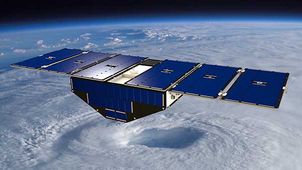
    The WAAS Test Team at the technical center has begun to monitor the Integrity Support Data (ISD) parameters of ARAIM using evaluation tools and methods developed by both the center and Stanford University. Results of this monitoring will be published in a quarterly report on the WAAS Test Team website.

    The Need for Advanced RAIM

    ARAIM addresses various weaknesses of Receiver Autonomous Integrity Monitoring (RAIM).

    To assure the integrity of GPS, aviation receivers implement RAIM, which detects any GPS satellite fault, and can then isolate and remove it from the navigation solution.

    However, RAIM provides integrity only for horizontal operations, such as enroute and non-precision approach. Additional integrity is needed to allow advanced capabilities, such as vertically guided approaches. Other integrity systems, including the Wide Area Augmentation System (WAAS), provide the integrity needed to permit these additional operations.

    Since RAIM’s debut, GPS and other GNSS have evolved to improve their performance and upgraded to add an additional civilian signal, making possible ARAIM architecture.

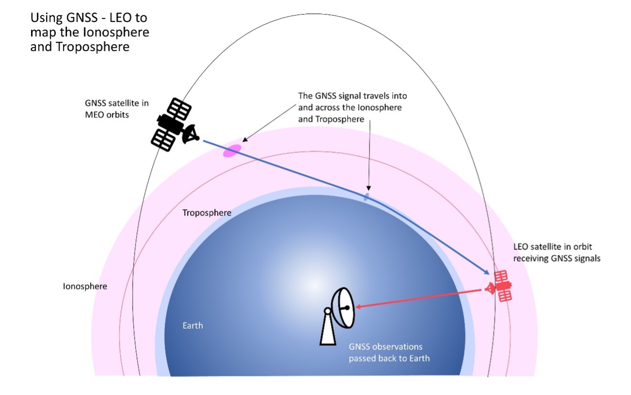
    ARAIM increases the geometric diversity and integrity availability by using two core GNSS constellations (such as GPS and Galileo). ARAIM takes advantage of the second civilian signal by specifying dual-frequency processing so that the ionospheric error from GNSS signals is directly measured by the user equipment.

    The ionosphere — in most cases, the largest source of error in a GNSS signal — can also reduce the integrity of GNSS signals. Data provided for ARAIM use can include improved performance commitments from the GNSS constellation. RAIM uses static values for those performance commitments.

    Enabling LPV-200 Approaches

    The dual-frequency multi-constellation ARAIM seeks to allow LPV-200 approaches worldwide. LPV-200 (localizer performance with vertical guidance) delivers accurate information on an aircraft’s approach to a runway with the use of GNSS positioning technology. The result is lateral and angular vertical guidance without the need for visual contact with the ground until an aircraft is 200 feet above the runway.

    ARAIM is considered an aircraft-based augmentation system: the algorithm to determine GPS integrity is in the aircraft receiver, just like RAIM. ARAIM could use both GPS and Galileo to achieve the worldwide LPV-200 service goal, with the integrity needed available from satellites of both constellations.

    Integrity Support Data. An important aspect of ARAIM is the integrity support message, which contains the ISD that describe a GNSS constellation’s accuracy and reliability. Each GNSS constellation service provider generates and updates its ISD data, while the receiver manages and uses each GNSS constellation message.

    The specific ISD parameters for ARAIM have not yet been finalized, but candidate data includes the probabilities of satellite and constellation failure (for instance, more than two satellites fail due to a common cause), user range error,  user range accuracy data, and other candidate data.

    The ISD will be finalized when the International Civil Aviation Organization (ICAO) Standards and Recommended Practices (SARPs) with the ARAIM requirements are completed.

    To ensure that the data provided in the ISM remains valid, external monitoring is needed. The external monitoring ensures the satellite and constellation failure probabilities provided in the ISM continue to be valid. External monitoring also characterizes the user range accuracy and user range error in the ISM.

    Read more about the project in the FAA’s SatNav News, Fall/Winter issue.

  • Thales wins  €100M EGNOS maintenance contract

    Thales wins €100M EGNOS maintenance contract

    Fabian Gysel/iStock/Getty Images Plus/Getty Images
    Fabian Gysel/iStock/Getty Images Plus/Getty Images

    Thales Alenia Space has signed a contract worth more than €100 million with the European Union Agency for the Space Programme (EUSPA) to provide maintenance for version 2 of EGNOS (European Geostationary Navigation Overlay System) for four years.

    Thales Alenia Space is a joint company between Thales (67%) and Leonardo (33%).

    EGNOS enhances the accuracy, reliability and integrity of positioning signals by improving the performance of GNSS. For instance, the EGNOS safety-of-life service is used in aviation for landings, enabling precision approaches at European airports without requiring ground guidance systems. The service has significantly improved operational safety and efficiency for European aviation.

    Thales Alenia Space will build on its expertise in engineering, development, testing and maintenance of the existing EGNOS, along with its current development of EGNOS V2, to provide maintenance of the EGNOS V2 system for EUSPA and the European Union satellite navigation community from 2023 to 2026.

    Thales Alenia Space will provide operational support and servicing in case of incidents — especially hardware and software troubleshooting and repairs — to deliver optimal 24/7 support for EGNOS. In addition, it will provide the upgraded or modified versions needed to ensure safety-of-life service.

  • NTS-3 Vanguard moves closer to 2023 launch

    NTS-3 Vanguard moves closer to 2023 launch

    News from the U.S. Air Force Research Laboratory (AFRL)

    The Navigation Technology Satellite-3 (NTS-3) Vanguard program has reached a milestone in preparation for launch of the satellite in late 2023. NTS-3 is expected to push the boundary of positioning, navigation and timing (PNT) technology, paving the way for a more flexible, robust and resilient architecture for satellite navigation.

    Prime contractor L3Harris Technologies delivered the NTS-3 space vehicle to an Air Force Research Laboratory (AFRL) integration and test facility at Kirtland Air Force Base, New Mexico. The satellite integrates an agile PNT payload with a Northrop Grumman ESPAStar bus to provide a space platform for AFRL and partner organization experiments and integrated capability demonstrations.

    In 2019, the U.S. Air Force designated NTS-3 one of the first three Vanguard programs to deliver innovative, game-changing capabilities to the warfighter at an accelerated pace. NTS-3 is managed by the AFRL Transformational Capabilities Office and has program partners in both the U.S. Space Force and the U.S. Air Force.

    “This major milestone marks the transition from space system development at contractor’s facilities to the final stage of integration and test activities,” said Arlen Biersgreen, NTS-3 program manager. “The AFRL team will be overseeing and working closely with L3Harris and other key industry partners to apply an effective combination of contractor and government resources to successfully complete this phase of the effort.”

    Arlen Biersgreen, NTS-3 program manager, uses a 1:3 scale model to describe the spacecraft and details of the one-year experimental mission during Media Day on June 23, 2022, at Kirtland Air Force Base. (Photo: U.S. Air Force/Andrea Rael)
    Arlen Biersgreen, NTS-3 program manager, uses a 1:3 scale model to describe the spacecraft and details of the one-year experimental mission during Media Day on June 23, 2022, at Kirtland Air Force Base. (Photo: U.S. Air Force/Andrea Rael)

    AFRL and L3Harris are now completing the remaining intra-payload and payload-to-bus functional and performance tests, including the first radio frequency broadcast tests of the novel PNT signals that will be demonstrated from near-geosynchronous orbit after the NTS-3 launch.

    Following those activities, the team will perform standard space environment tests that simulate the launch and space environments to verify that the system is ready for the rigors of experimental operations in space. Biersgreen added that experimental performance data from ground testing will be available for sharing with program partners in the next several months.

    The Global Navigation Satellite System Test Architecture, or GNSSTA, developed by the Mitre Corporation in partnership with the AFRL Sensors Directorate, is crucial for meeting end-to-end NTS-3 mission objectives. GNSSTA is a reprogrammable software-defined receiver allowing users to receive both legacy GPS and advanced signals generated by NTS-3. It lays the groundwork for future operational receivers to provide the Space Force with options to prevent and respond quickly to common threats on the battlefield, such as GPS jamming and spoofing.

    Joanna Hinks, NTS-3 principal investigator, worked closely with the Sensors team on GNSSTA development and testing. “The entire team is excited that earlier this month, we successfully generated signals on the actual spacecraft and received them with our experimental GNSSTA user equipment,” Hinks said. “Showing the space segment and user segment working together like that is an important step to being ready to conduct experiments on-orbit.”

    NTS-3 is the first U.S. experiment of its kind in nearly 50 years, since the Navy Research Laboratory’s NTS-1 and NTS-2 spacecraft led the way for the GPS constellation in the 1970s.

    “This Vanguard not only aims to support GPS users through vital development of new technologies and techniques, but also to show how an agile and responsive U.S. satellite navigation architecture is paramount to defeating the most challenging threats to warfighter success, both today and through the coming decades,” Biersgreen said.

    The NTS-3 spacecraft was placed in an anechoic test chamber for electromagnetic interference and electromagnetic compatibility testing in Palm Bay, Florida. (Photo: AFRL)
    The NTS-3 spacecraft was placed in an anechoic test chamber for electromagnetic interference and electromagnetic compatibility testing in Palm Bay, Florida. (Photo: AFRL)
  • Seen & Heard: Autonomous vehicles and Apple AirTags

    Seen & Heard: Autonomous vehicles and Apple AirTags

    “Seen & Heard” is a monthly feature of GPS World magazine, traveling the world to capture interesting and unusual news stories involving the GNSS/PNT industry.


    Image: iStock/Getty Images Plus/Getty Images
    Image: iStock/Getty Images Plus/Getty Images

    San Francisco Not Keen on Avs

    San Francisco officials aren’t happy with autonomous vehicles (AV) on their streets. They say the AVs are at fault for traffic violations and congestion, delays in emergency response and public transport — even trips onto public sidewalks. California officials granted the first AV deployment permits this year, allowing companies to release self-driving cars onto city streets and to provide passenger service as robotaxis. State governments have the legal power to grant permits to AV companies to conduct testing and ride-hail services, leaving city officials powerless to control self-driving car incidents that affect public safety.


    (Image: Apple)
    Image: Apple

    AirTag under Fire 

    Two women have filed a class-action lawsuit against Apple, claiming its AirTag trackers are being used for malicious and criminal purposes. Both women say they were tracked by ex-partners using Apple AirTags hidden in their belongings. They are seeking damages for negligence and privacy violations, and are hoping to prevent Apple from continuing to manufacture the product with “design flaws.”


    (Image: TU Delft/Frank Auperlé)
    Image: TU Delft/Frank Auperlé

    Navigating Urban Canyons with SuperGPS 

    Researchers at Delft University of Technology, Vrije Universiteit Amsterdam and VSL have developed an alternative positioning system that is more robust and accurate than GPS, especially in urban settings. The aim of the project — SuperGPS — was to develop an alternative positioning system that makes use of mobile telecommunications networks instead of satellites and that has better accuracy than GPS. A prototype of the infrastructure achieved an accuracy of 10 centimeters. The new technology is important for the implementation of a range of location-based applications, including automated vehicles, quantum communication and next-generation mobile communication systems.


    (Image: Allison Usavage/Cornell University)
    Image: Allison Usavage/Cornell University

    Robots Head to Vineyards

    Cornell researchers have designed PhytoPatholoBots (PPB) that will be deployed in vineyards across the country next spring in the first of a four-year project at Cornell, which is led by the University of Minnesota. The autonomous robots will collect data on the health of each grapevine, helping growers to evaluate their vineyards. The robots are part of the Specialty Crops Research Initiative, bringing innovation to the wine and grape industries.

  • Abstracts sought for ION Joint Navigation Conference

    Abstracts sought for ION Joint Navigation Conference

    Photo: ION
    Image: ION

    The Institute of Navigation (ION) has opened abstract submissions for Joint Navigation Conference (JNC) 2023, which takes place June 12–15 at the Town and Country Hotel in San Diego, California. JNC 2023 is the largest U.S. military positioning, navigation and timing (PNT) conference of the year with joint service and government participation.

    Abstract selection for JNC 2023 is expected to be competitive, according to ION. All abstracts must be written for public release with intent to present in a Controlled Unclassified Environment (CUI) U.S. Only environment. Abstracts not meeting the established criteria, received by Feb. 3, will not be considered.

    The event will focus on technical advances in PNT with emphasis on joint development, testing and support of affordable PNT systems, logistics and integration. From an operational perspective, the conference will focus on advances in battlefield applications of GPS; critical strengths and weaknesses of field navigation devices; warfighter PNT requirements and solutions; and navigation warfare.

    CUI U.S. only conference attendance will be screened by the Joint Navigation Warfare Center and will be restricted to U.S. only. The exhibit hall (June 13-14) will be open to all conference participants, exhibitors, their employees and related organizations. All materials displayed in the exhibit hall must be publicly releasable after review.

  • Papers sought on GNSS applications for water vapor observations

    Papers sought on GNSS applications for water vapor observations

    Photo: RussieseO/iStock/Getty Images Plus/Getty Images
    Image: RussieseO/iStock/Getty Images Plus/Getty Images

    Conveners of a session on GNSS applications for water vapor observations are seeking research paper submissions. The session will take place during the Asia Oceania Geosciences Society (AOGS) Conference 2023 taking place July 30 to Aug. 4 in Singapore.

    Session AG06 is titled “Assimilation of Space- and Ground-based Water Vapor Observations for Weather Forecasting and GNSS Applications.”

    Observation of water vapor is one of the priorities in the Global Climate Observing System. Obtaining and exploiting additional high-quality humidity observations from GNSS and other remote sensing techniques is essential to improve weather forecasting and climate monitoring, the session conveners explained.

    Abstract contributions are being sought on the topic, such as:

    • new algorithms to estimate water vapor from ground-based and space-based techniques, such as ground-based GNSS, space-based RO, InSAR, visible/near-infrared/infrared/microwave sensors and other sensors
    • retrieval and inter-comparison of water vapor among multiple instruments
    • assimilation and analysis of water vapor products from ground-based GNSS, space-based RO, InSAR, and various remote sensing/meteorological satellites for nowcasting and weather forecasting
    • use of numerical weather prediction models for modeling outputs as atmospheric corrections for GNSS, InSAR, VLBI and other geodetic observation techniques
    • estimation of atmospheric parameters from crowdsourcing equipment
    • atmospheric products for climate, hydrology, natural disasters and others.

    The submission deadline is Feb. 14. Submit abstracts here.

    For more information about the session, go here and select AS06 (Atmospheric Sciences AS06).

  • Mapping Marvel: Off the Beaten Path

    Mapping Marvel: Off the Beaten Path

    Paris Austin, head of product – New Technology for OxTS, tries out the new backpack at historic Minster Lovell Hall. (Image: OxTS)
    Paris Austin, head of product – New Technology for OxTS, tries out the new backpack at historic Minster Lovell Hall. (Image: OxTS)

    More than 400,000 sites in the United Kingdom are on its historical registries. English Heritage site Minster Lovell Hall is located in Oxfordshire, also the home county of inertial navigation company OxTS. The picturesque ruins of Minster Lovell Hall, a 15th-century manor house, include the hall, a tower and a nearby dovecote.

    The hall was built in the 1430s by William, Baron of Lovell and Holand — one of the richest men in England. It was later home to Francis, Viscount Lovell, a close ally of Richard III. After changing hands several times, the hall was abandoned and eventually demolished in the 18th century, leaving the extensive remains that stand today.

    (Image:OxTS)
    (Image: OxTS)

    The buildings are grouped around a central courtyard in a plan characteristic of a late medieval manor house. For OxTS, the site proved suitable for testing its prototype backpack. The site features dense tree canopies on one side, tight doorways, narrow views of the sky, and plenty of height to test the angled mounting of the survey-focused lidar for when GNSS is denied. Open-sky areas allowed the OxTS team to return to real-time kinematic (RTK) surveying before moving on to another section of the site.

    Reconstruction drawing of Minster Lovell Hall as it might have appeared in the 15th century, by artist Alan Sorrell. (Image: English Heritage)
    Reconstruction drawing of Minster Lovell Hall as it might have appeared in the 15th century, by artist Alan Sorrell. (Image: English Heritage)

    The prototype backpack is based on the OxTS setup for vehicles but was created to enable quick data collection without a car. It is equipped with two Hesai lidar sensors, a new OxTS prototype inertial navigation system and an antenna. The team can connect it to a laptop for configuration and to optimize lever arms and the boresight. Once post-processed with OxTS Georeferencer software, the point cloud below was produced.

    OxTS designed the backpack to meet a growing need for localization and georeferencing in both GNSS-denied areas and those that cannot be reached by car, including the construction, environmental, conservation and heritage industries.

  • Galileo HAS now operational with 20-cm accuracy

    Galileo HAS now operational with 20-cm accuracy

    The high-accuracy service (HAS) offered by Galileo is now available and provides sub-meter accuracy over most of the globe. It will help enable emerging technologies such as UAVs and autonomous vehicles, which require stringent levels of accuracy for better navigation, safety and efficient traffic management.

    Other industries expected to benefit include transportation, agriculture, geodesy and entertainment.

    Thierry Breton, European commissioner for Internal Market, announced that the service was now live during the annual European Space Conference in Brussels, Belgium, on Jan. 24.

    The European Union Agency for the Space Programme (EUSPA) developed Galileo HAS along with the European Commission and the European Space Agency (ESA). The new service will become a pillar of government programs such as EU sectorial policies and national policies by EU Member States.

    “This new service has been made possible thanks to the outstanding cooperation and team commitment of all involved partners,” said Rodrigo da Costa, EUSPA executive director.

    “Galileo is not standing still,” said Javier Benedicto, ESA director of navigation. “This new High Accuracy Service offers a new dimension of precision to everyone who needs it, while the Open Service Navigation Message Authentication — already available — allows users to authenticate Galileo signals as they make use of it, to minimize any risk of spoofing. An upgraded integrity message of the signal rolled out last year reduces the time to first fix while enhancing the overall robustness of Galileo.”

    Galileo HAS delivers horizontal accuracy down to 20 cm and vertical accuracy of 40 cm in nominal use conditions, according to ESA. The service is transmitted directly via the Galileo signal in space (E6-B) and through the internet.

    With HAS, Galileo becomes the first constellation worldwide able to provide a high-accuracy service globally and directly through the signal in space.

    The service is freely accessible to all users with a receiver capable of processing the HAS corrections broadcast in the E6-B signal and via the internet. The precise corrections provided by Galileo HAS will allow users to reduce the error associated with the orbit and clocks provided through the Galileo Open Service broadcast navigation messages and the GPS Standard Positioning Service navigation data.

    “With the Galileo HAS we are ready to unleash the full potential of new technologies such as drones and bring autonomous driving closer to reality,’’ da Costa said. “At EUSPA, our role is to link space to user needs. With the launch of this new service, we met a clear market demand for accurate, robust, and reliable navigation.”

    All HAS-related documentation and additional information about the Galileo services can be found on the European GNSS Service Centre website.

    Image: metamorworks/iStock/Getty Images/Getty Images
    Image: metamorworks/iStock/Getty Images/Getty Images
  • Copernicus Sentinel-3 and Sentinel-6 GNSS orbital products available

    Copernicus Sentinel-3 and Sentinel-6 GNSS orbital products available

    Artist's depiction of the Copernicus Sentinel-6 satellite, launched in November 2020. (Image: ESA)
    Artist’s depiction of the Copernicus Sentinel-6 satellite, launched in November 2020. (Image: ESA)

    The Copernicus Precise Orbit Determination (CPOD) Service, in charge of computing precise orbits for the Copernicus Sentinel-1, -2, -3 and -6 missions,  routinely publishes GNSS and quaternions data and precise orbital products of these missions on the POD Data Hub of the Copernicus Open Access Hub.

    The following products are published:

    1. Sentinel-1, 2, 3 A&B GNSS RINEX observation files (AUX_GNSSRD)
    2. Sentinel-1, 2, 3 A&B Quaternions files (AUX_PROQUA)
    3. Sentinel-1 A&B CPOD Predicted Orbits (AUX_PREORB)
    4. Sentinel-1 A&B CPOD Restituted Orbits (AUX_RESORB)
    5. Sentinel-1 A&B CPOD Precise Orbits (AUX_POEORB)
    6. Sentinel-3 A&B CPOD Restituted Orbits (SR___ROE_AX)
    7. Sentinel-3 A&B CPOD Medium Orbit (AUX_RESORB)
    8. Sentinel-3 A&B CPOD Precise Orbits (AUX_POEORB)
    9. Sentinel-3 A&B CPOD Precise Platform data (AUX_PRCPTF)

    The following new products from Sentinel-3 and Sentinel-6 are now available as well. The Sentinel-6A GNSS RINEX observations include GPS and Galileo data — the first publicly available Galileo data obtained from an orbiting receiver.

    1. Sentinel-3A&B CNES Medium Orbit Ephemeris (SR___MDO_AX)
    2. Sentinel-3A&B CNES Precise Orbit Ephemeris (SR___POE_AX)
    3. Sentinel-6A CNES Medium Orbit Ephemeris (AX____MOED_AX)
    4. Sentinel-6A CNES Precise Orbit Ephemeris (AX____POE__AX)
    5. Sentinel-6A CPOD Restituted Orbit Ephemeris (AX____ROE__AX)
    6. Sentinel-6A GNSS RINEX observation files (AUX_GNSSRD)
    7. Sentinel-6A Quaternions files (AUX_PROQUA)

    The GNSS RINEX (AUX_GNSSRD) and Quaternions files (AUX_PROQUA), together with the final orbital products (AUX_POEORB, AUX_PRCPTF, SR___POE_AX, and AX____POE__AX) are available at the beginning of each mission.

    The other orbital products (AUX_RESORB, SR___ROE_AX, SR___MDO_AX, AX____MOED_AX, and AX____ROE__AX) are available for at least one month, until the final products are available.

    The typical accuracy of the orbital products can be found in the Regular Service Reviews carried out by the CPOD Service quarterly.

    Details about these products can be found in the POD Product Handbook.

    Auxiliary data needed for precise orbit determination, such as maneuvering information, can be found in the Sentinel online:

    Please send questions to mailto:[email protected].

  • NASA loses contact with CYGNSS hurricane satellite

    NASA loses contact with CYGNSS hurricane satellite

    Artist's concept of one of the eight CYGNSS satellites in orbit. (Image: NASA/University of Michigan)
    Artist’s concept of one of the eight CYGNSS satellites in orbit. (Image: NASA/University of Michigan)

    Since Nov. 26, NASA’s Cyclone Global Navigation Satellite System (CYGNSS) team has not been able to make contact with one of the eight CYGNSS spacecraft, FM06.

    The team is still working to acquire a signal and establish a connection.

    The other seven spacecraft continue to operate normally and have been collecting science measurements since the FM06 anomaly.

    CYGNSS is a constellation of eight small satellites taking measurements of ocean surface winds in and near the eye of the storm throughout the lifecycle of tropical cyclones, typhoons and hurricanes.

    If the team isn’t able to reestablish contact, loss of the FM06 satellite would primarily affect the constellation’s spatial coverage. However, the CYGNSS constellation can continue to meet its scientific requirements and objectives.

    CYGNSS was launched Dec. 15, 2016, and completed its prime mission science objectives on March 19, 2019. It has been operating in extended mission status since then.

  • Space Force enhances GPS ground communications for greater resiliency

    Space Force enhances GPS ground communications for greater resiliency

    Modernized communications lines were installed at seven locations worldwide in an overhaul of the global communications network that provides command and control of the GPS constellation.

    Kwajalein Atoll in the Marshall Islands is one of seven locations that received a GPS communications network overhaul.(Photo: USGS)
    Kwajalein Atoll in the Marshall Islands is one of seven locations that received a GPS communications network overhaul.(Photo: USGS)

    From 2018 to 2022, GPS Product Support Delta — in conjunction with the Defense Information Systems Agency (DISA) — performed a complete overhaul of the global communications network required to provide command and control of the GPS satellite constellation. GPS Product Support Delta is under Space Systems Command of the U.S. Space Force.

    The project, called GPS Operations Network Enhancements (GONE), connected multi-protocol label switching internet protocol (IP)-based routers to modernized communications lines at seven key GPS facilities, replacing older serial lines.


    “With the GONE project completed, we are seeing a 75 percent reduction in communication line interruptions.”


    The GONE initiative “has significantly enhanced communications for GPS weapon systems,” said Brian Botka, Product Support Delta GPS program manager.

    “These upgrades not only increase communications speed and reduce overall down-time and adding a new paradigm in network resiliency with the networks capable of recovering in mere seconds from an outage or issue,” said Sean Foley, DISA technical project manager. “The system upgrades will continue to improve service to the warfighter as well as enable increased resiliency and network diversity for DISA.”

    The modernized communications lines were installed at

    • Schriever Space Force Base, Colorado
    • Vandenberg SFB, California
    • Cape Canaveral Space Force Station, Florida
    • Facilities in Hawaii, Ascension Island, Diego Garcia and Kwajalein Atoll.

    Throughout the COVID-19 pandemic, many of these locations were under strict lockdown or required long quarantine periods, making coordination and travel to remote locations more challenging.

    Lockheed Martin was the contractor who supported Product Support Delta GPS on the GONE project. “This was a collaborative effort with Product Support Delta GPS and DISA that required significant logistical efforts due to the COVID-19 pandemic,” said Christina Mancinelli, Lockheed Martin GPS Ground Programs director.

    “With the GONE project completed, we are seeing a 75 percent reduction in communication line interruptions, and we expect that metric to continue to improve,” Mancinelli said. “The migration of the GPS communication lines to the modern MPLS [multiprotocol label switching] routers and Ethernet-based connections continues the significant improvements in GPS ground capability, cybersecurity and reliability.”

    SSC is the USSF field command responsible for rapidly identifying, prototyping, and fielding resilient space capabilities for joint warfighters. It delivers sustainable joint space warfighting capabilities to defend the nation and its allies while disrupting adversaries in the contested space domain.

    SSC mission areas include launch acquisition and operations; space domain awareness; positioning, navigation, and timing; missile warning; satellite communication; and cross-mission ground, command and control and data.

  • FrontierSI to support Australia’s Ginan for LEO satellites

    FrontierSI to support Australia’s Ginan for LEO satellites

    FrontierSI has signed a collaborative agreement with Geoscience Australia, Curtin University and the University of Newcastle to enhance Ginan with features specifically aimed at supporting low-Earth orbit (LEO) satellites as an important component of Geoscience Australia’s Positioning Australia program.

    Ginan is Geoscience Australia’s GNSS analysis center software. It delivers a real-time positioning correction service through open-source software and additional positioning products to enable precise point positioning for Australian industry and users.

    The design, development and deployment of LEO satellites has grown significantly over the last decade. The agreement with FrontierSI complements ongoing Ginan precise orbit determination (POD) development activities, focusing on the implementation of LEO satellite modeling and the orbit integrator/propagator capabilities needed to enable LEO GNSS data to be processed and high-precision LEO satellite trajectories estimated and predicted.

    Such a capability will enable:

    • better monitoring of LEO satellites for station keeping, collision avoidance and end-of-life purposes
    • improved ionosphere and troposphere monitoring and modeling through the analysis of GNSS signal occultation, to provide data for weather prediction and precise positioning purposes.

      Image: GINAN
      Image: Ginan

    Learn more about Ginan here.