Author: Tracy Cozzens

  • PEAK System offers inertial measurement unit

    PEAK System offers inertial measurement unit

    PEAK System has introduced the PCAN-GPS Pro FD, a configurable sensor module for measuring the position, attitude and acceleration of objects. It has a robust aluminum housing suited for measurement in harsh environments.

    The device is equipped with a powerful microcontroller (M7/M4 dual-core), a magnetic field sensor, a three-axis gyroscope, a three-axis accelerometer, and the u-blox NEO-M9N satellite receiver for GPS, Galileo, BeiDou, GLONASS, SBAS and QZSS. It delivers satellite navigation measurement data with update rates of up to 25 Hz.

    The module transmits the sensor data via two parallel LEMO circular connectors via CAN 2.0 A/B (40 kbit/s to 1 Mbps) or CAN FD (40 kbit/s to 10 Mbps). The PCAN-GPS Pro FD is configured via USB-C using Windows software (included in delivery), after which the module operates as a standalone CAN node. The aluminum profile housing (IP50/IP54 with sealing connectors) ensures high protection and easy integration.

  • Astradia star tracker designed to fill in for GNSS

    Astradia star tracker designed to fill in for GNSS

    Sodern announces the commercial launch of Astradia, a daytime star tracker which, when combined with an inertial navigation system, allows more precise and robust navigation under GNSS-denied environments.

    Specifically designed for civil and military aircraft, Astradia can operate day or night guided by stars. Astradia offers tracking capacity to within a few arc-seconds, equivalent to 1 meter at a distance of 70 km. This function, which is extremely useful for aligning inertial navigation systems or its registration during mission, opens the door to applications with demanding tracking requirements, including stealth missions.

    The sensor delivers measurements to the aircraft without interruption, providing operational capacity at any point on Earth, including over the oceans, with no need to update maps or charts in order to carry out the mission. This sensor effectively reduces navigation drift during long flights and more generally improves the security of in-flight positioning.

    Astradia is an endo-atmospheric star tracker that provides daytime and nighttime attitude measurement, for precise, robust and reliable onboard geopositioning data. It helps counter the natural drift in inertial navigation systems. It also offers the advantage of emitting no waves, which could otherwise expose an aircraft to detection.

    Astradia is compact (176 mm x 185 mm x 207 mm) and weighs less than 3 kg. It was specifically designed for easy integration on all types of aircraft. This optimized design makes Astradia ideal for a wide range of applications, including drones and surveillance aircraft.

    Several thousand of Sodern’s star trackers are already in service, along with a star catalogue and proven detection algorithms. This technology has also undergone conclusive in-flight testing.

    Astradia will be featured at the Sodern stand during the 2025 International Paris Air Show.

  • Honeywell adds IMU to navigation lineup

    Honeywell adds IMU to navigation lineup

    Honeywell has expanded its navigation portfolio with the HG3900 inertial measurement unit (IMU), a lightweight and low-power tactical-grade device with accuracy and reliability comparable to larger near-navigation-grade IMUs.

    Honeywell will showcase the HG3900 IMU, along with the rest of its navigation products, at the Joint Navigation Conference in Cincinnati June 2-5, including a feature session on June 4.

    The HG3900 is comprised of all-silicon microelectromechanical system (MEMS) gyroscopes and accelerometers, which enables a significant reduction in size, weight and power from comparable IMUs using traditional technologies. Its advanced sensors significantly boost its performance by offering a 20-time improvement over other Honeywell MEMs.

    The HG3900 is designed for backward compatibility. As the highly successful Honeywell HG1900 IMU nears its end of life, the HG3900 will be offered in a nearly identical package to enable an easy transition for existing HG1900 customers.

    The HG3900 IMU has successfully completed full environmental testing by the U.S. Army and Navigation Technology Associates (NTA), meeting requirements while under demanding environmental conditions including high vibration and dynamic temperature changes.

    “Our HG3900 IMU is an ideal solution for customer applications requiring tactical or near-nav grade performance in a small, lightweight package,” said Matt Picchetti, vice president and general manager, Navigation and Sensors, Honeywell Aerospace Technologies. “Extensive Honeywell and customer testing demonstrates that our new IMU offers superior real-world performance in a smaller package.”

    IMUs are widely used on aircraft, ships, spacecraft and other applications where precision positioning and navigation are critical. The importance of these devices has intensified considerably over the past decade with the significant growth in autonomous vehicles and other autonomy use cases. IMUs utilize gyroscopes, accelerometers and electronics to determine where a vehicle is, what direction it is going, at what speed and how far it has travelled.

    Advanced MEMS IMUs such as the HG3900 are highly resilient and can provide accurate navigation and orientation data with or without GNSS inputs. They can function independently for extended periods when GNSS signals are jammed, spoofed or unavailable.

    The design verification process will continue into 2026 with initial production and deliveries to begin in late 2026 or early 2027. Honeywell is accepting orders for pre-production units for delivery in 2026.

  • Solar Storm may impact GPS

    Solar Storm may impact GPS

    A geomagnetic storm expected today and tomorrow has been upgraded to G4 (severe) by the National Oceanic and Atmospheric Administration (NOAA). Solar storms can disrupt GPS and GNSS signals before they arrive on Earth.

    According to NOAA, a powerful coronal mass ejection (CME) erupted from the Sun the evening of May 30. Confidence in an Earth-directed component is good, but the CME arrival timing is more uncertain due to the current state of the solar wind. It could arrive as early as late morning EDT, to as late as Sunday evening EDT June 1.

    Conditions will likely intensify as CME progression continues and G4 levels remain possible on Monday, June 2.

    The center of the bulk CME material is anticipated to be just north of Earth. However, Earth will still likely undergo passage of much of the CME material. Arrival will likely lead to immediate geomagnetic disturbances with the potential for G4.

    Conditions will likely intensify as CME progression continues and G4 levels remain possible on Monday, June 2.

    Geomagnetic storm levels will likely begin subsiding by Tuesday with G1-G2 (Minor-Moderate) still possible.

    Visit the NOAA website for the latest information and updates.

  • 3D scan of Titanic reveals new details of shipwreck

    3D scan of Titanic reveals new details of shipwreck

    In 2022, deep-sea mapping company Magellan undertook the largest underwater 3D scanning project of its kind to create the first full-size digital scan of the Titanic. The luxury passenger liner sank in the North Atlantic Ocean on April 15, 1912, after striking an iceberg, and now rests 12,500 ft below the surface.

    Over three weeks, the Magellan team worked around the clock to capture the luxury vessel in unparalleled detail. They used two remotely operated vehicles (ROVs) — dubbed Romeo and Juliet — to systematically canvass the site. In total, the ROVs collected 715,000 photos, 4K footage and millions of laser measurements — a total of 16 terabytes of data.

    The scan itself was only the beginning. The Magellan team then processed the collected data into a smooth, comprehensive 3D point cloud. Applying new processing techniques to the original Magellan IP and raw data sets provided a new data set with 35% better resolution and accuracy. Each point in the dense point cloud used to generate the model has its unique set of Cartesian coordinates(X,Y, Z), time stamp and texture.

    A National Geographic documentary
about the project, “Titanic: The Digital
Resurrection,” is now streaming on
Disney+ and Hulu. The 90-minute
documentary was produced by Atlantic
Productions for National Geographic. (Photo: Magellan Limited/Atlantic Productions)
    A National Geographic documentary about the project, “Titanic: The Digital Resurrection,” is now streaming on Disney+ and Hulu. The 90-minute documentary was produced by Atlantic Productions for National Geographic. (Photo: Magellan Limited/Atlantic Productions)

    Titanic analyst Parks Stephenson has visited the actual Titanic wreck twice, but the virtual scan revealed
    details he never saw before. Aboard a submersible, with its six-inch viewport and limited camera views, details are easily missed. “It’s like being in a dark room and you have a flashlight that’s not very
    powerful,” Stephenson told National Geographic. The digital twin gave him an unobstructed, 360° view of every nook and cranny.

    The digital twin reconstructs Titanic’s structural collapse in forensic detail. A video rendering of it can be projected to life-size in a warehouse, allowing experts to walk through its final moments. For instance, an open steam valve in the boiler room validates eyewitness accounts that the ship’s engineers remained at their posts for more than two hours after impact, keeping the electricity on and allowing wireless distress signals to be sent. The 35 men may have saved hundreds of lives while sacrificing their own.

    Photo: Magellan Limited/Atlantic Productions
    Photo: Magellan Limited/Atlantic Productions

    The digital scan also helps exonerate First Officer Murdoch, long accused of abandoning his post. The position of a lifeboat davit suggests his crew was preparing a launch moments before the starboard side was engulfed, corroborating Second Officer Charles Lightoller’s testimony that Murdoch was swept away by the sea.

    The scans reveal the wreck’s alarming deterioration, with iconic areas collapsing. But the mapping project means the ship is now digitally preserved, along with similar models of historic sites around the world.

    Magellan has launched an app built on
the Titanic’s scans, available in Early
Access on the Steam platform. “vROVpilot:
TITANIC” puts users in the pilot seat of
a virtual ROV to explore the wreck and
complete missions to scan its key features.
The experience comprises an accurate
ROV user interface, along with realistic
underwater condition visual effects and
comprehensive sound effects, according to
the developer.
So far, the app is using only the data
on the bow, which is less than 35% of the
full data set. The stern is expected to be
added next, followed by the 15-squaremile debris field, which shows personal
effects such as pocket watches, purses,
gold coins, hair combs, shoes and a
Megalodon-tooth necklace.
    Magellan has launched an app built on
    the Titanic’s scans, available in Early
    Access on the Steam platform. “vROVpilot:
    TITANIC” puts users in the pilot seat of
    a virtual ROV to explore the wreck and
    complete missions to scan its key features.
    The experience comprises an accurate
    ROV user interface, along with realistic
    underwater condition visual effects and
    comprehensive sound effects, according to
    the developer.
    So far, the app is using only the data
    on the bow, which is less than 35% of the
    full data set. The stern is expected to be
    added next, followed by the 15-squaremile debris field, which shows personal
    effects such as pocket watches, purses,
    gold coins, hair combs, shoes and a
    Megalodon-tooth necklace. (Photo: Magellan Limited/Atlantic Productions)
  • GNSS receivers show how earthquake sound waves move

    GNSS receivers show how earthquake sound waves move

    Scientists at Japan’s Nagoya University have used Japan’s extensive network of GNSS receivers to create the first 3D images of atmospheric disturbances caused by the 2024 Noto Peninsula Earthquake. Their results show sound wave disturbance patterns in unique 3D detail and provide new insights into how earthquakes generate these waves.

    The team published the results in the journal Earth, Planets and Space (May 29, DOI 10.1186/s40623-025-02211-y).

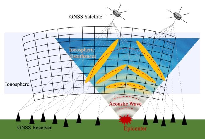
    Japan has one of the densest GNSS networks in the world, with more than 4,500 receivers spread across the country. The network helps with precise location tracking and can also detect changes in the ionosphere.

    A research team led by Dr. Weizheng Fu and Professor Yuichi Otsuka from Nagoya University’s Institute for Space-Earth Environmental Research (ISEE) has captured the detailed 3D structure of electron density changes in the ionosphere after the 7.5 magnitude Noto Peninsula Earthquake that occurred on January 1, 2024, in Ishikawa Prefecture, Japan. 

    When satellite signals travel through the ionosphere, they slow down because the radio waves interact with electrically charged particles. By measuring how much the signals slow down, scientists can calculate how many electrons are in the signals’ path and map the total electron content. Mapping these electrons allows them to effectively probe and monitor the state of the ionosphere. 

    About 10 minutes after the earthquake, the sound waves it generated traveled upward through the atmosphere and reached the ionosphere (60-1000 km above Earth). This created ripple disturbances similar to throwing a stone in a pond. 

    To build a 3D model of wave patterns, the researchers used a technique called “tomography” — similar to how CT scans create 3D images of the human body. They collected data on electron numbers from thousands of receivers tracking signals from satellites at different angles. By tracking their 3D models at different times after the earthquake, they created a time series of how electron density changed.  

    Sound waves generated from entire fault lines, not single points 

    South of the epicenter, the researchers observed a tilted sound wave pattern that gradually became more vertical over time. When an earthquake creates sound waves that travel upward through the atmosphere, the upper parts of the waves move faster than the lower parts. This makes the wave front lean or tilt as it moves. Over time, the tilted pattern gradually straightens into a more vertical alignment.  

    The researchers produced the first detailed 3D visualization of how the tilt angle changes over time during a seismic event. They tracked how the tilted wave patterns gradually straightened in unprecedented detail.

    Earthquakes do not create atmospheric waves from just one spot, but rather from multiple points along the entire fault as different sections rupture over time. This explains why the atmospheric disturbances observed, such as tilted waves, were more complex than previous simpler models had predicted. 

    Previous models assumed all sound waves came from a single point at the earthquake’s center. While this matched some of their observations, it could not explain the complex, uneven wave patterns they saw in their 3D images.  

    To understand this, they included data from multiple wave sources along the fault line in their model, assuming that some parts of the fault generated waves about 30 seconds after the initial rupture. The results better matched their real-world observations and showed that earthquakes do not create atmospheric waves from just one spot, but rather from multiple points along the entire fault as different sections rupture over time. This explains why the atmospheric disturbances observed, such as tilted waves, were more complex than previous simpler models had predicted. 

    “By including multiple distributed sources and time delays, our improved modeling provides a more accurate representation of how these waves propagate through the upper atmosphere,” Professor Otsuka said. 

    “Disturbances in the ionosphere can interfere with satellite communications and location accuracy. If we understand these patterns better, we could improve our ability to protect sensitive technologies during and after earthquakes and enhance early warning systems for similar natural events,” lead author Weizheng Fu added. 

    Moving forward, the researchers are working on applying their model to other natural events such as volcanic eruptions, tsunamis, and severe weather events.

  • Taoglas Thunder enclosures simplify router installations

    Taoglas Thunder enclosures simplify router installations

    Taoglas has launched its new Thunder Series — a high-performance outdoor antenna enclosure platform engineered to support direct integration and installation of industrial routers within the antenna package. Designed for demanding outdoor environments, the series helps engineers optimize installations, reduce signal loss, and significantly lower deployment costs.

    Purpose-built for widely deployed routers from Digi, Ericsson and Semtech, the Thunder Series combines Taoglas’ wideband antenna technology with a rugged enclosure that allows the router to be installed directly inside the housing. This significantly reduces the need for long RF cables – cutting tens of meters per deployment – while minimizing signal loss, installation time, and the material and labor costs typically associated with separate device installations.

    Thunder is being deployed in number plate recognition systems, powered directly from streetlight DC infrastructure – reducing cabling requirements and enabling discreet, efficient installation in urban environments.

    Operating across a broad 600–6000 MHz frequency range, the Thunder Series supports 5G/4G, Wi-Fi, GNSS and Bluetooth. This wide coverage enables support for low-band cellular, mid-band 5G, and Wi-Fi 6/6E frequencies. The solution provides quality communication by locating the router and the antenna in the same enclosure to minimize cable loss and reduce installation costs while simplifying implementation and deployment. This ensures long-range performance and reliable high- or low-speed data connectivity. The addition of the POE splitter makes powering the router less complicated.

    The Thunder Series is available in directional and omnidirectional versions, with IP67-rated ABS enclosures protecting against water ingress, dust and vibration. It is well-suited for harsh outdoor conditions and mission-critical deployments across transportation, mining, agriculture, smart cities and industrial automation. In one such application, Thunder is being deployed in number plate recognition systems, powered directly from streetlight DC infrastructure – reducing cabling requirements and enabling discreet, efficient installation in urban environments.

    To support flexible deployment, the Thunder Series can be powered in several ways depending on the router in use. These include dedicated power inputs or Power over Ethernet (PoE), with Taoglas providing detailed guidance to ensure safe, standards-compliant installation.

    The Thunder Series is available now via the Taoglas website and through the company’s authorized distribution network.

  • Ukraine’s Ruta missile to get EW-immune navigation system

    Ukraine’s Ruta missile to get EW-immune navigation system

    The Ruta OWA drone — actively used by Ukrainian forces for strikes at ranges up to 300 km — is being improved with a new visual navigation system, tested in combat conditions.

    The Ruta, manufactured by Destinus, is essentially a miniature cruise missile. It is often referred to as a “missile drone.” It will receive a new navigation system enabling high-precision strikes in GPS-denied contested environments, especially those from enemy electronic warfare (EW) countermeasures.

    The new navigation and guidance system will be provided by Spanish company UAV Navigation, part of Grupo Oesía, which entered an agreement with the Ukrainian Destinus on May 13.

    The agreement will focus on Ruta in its first phase. Ruta is the first low-cost missile (LCM) drone developed by Destinus designed to operate in highly contested scenarios. The system incorporates an advanced guidance, navigation and control system, developed by UAV Navigation-Grupo Oesía, which has been validated in real-world combat conditions, including GNSS-denied environments or under jamming and spoofing attacks.

    Ruta offers autonomous flight capabilities, target-referenced navigation, terminal optical guidance, and coordinated swarm operations, enabling the execution of complex synchronized attack maneuvers to saturate or deceive defense systems. The platform flies at a cruising speed of Mach 0.8, has a range of up to 500 km, and a terminal impact accuracy of 15 square meters.

  • Hi-Target and GMV sign strategic alliance on high-precision positioning solutions

    Hi-Target and GMV sign strategic alliance on high-precision positioning solutions

    Hi-Target, a Chinese high-precision positioning enterprise and manufacturer of high-end GNSS equipment, and GMV, a global technology group specializing in advanced navigation solutions, have established a strategic alliance to jointly develop integrated differential service solutions.

    Through this partnership, Hi-Target and GMV support a wide range of automation-driven positioning applications — ADAS, robotics, UAVs, precision agriculture, smart infrastructure and intelligent mobility systems.

    As industries progressively adopt automated technologies, precise and reliable positioning has become a foundational requirement across application domains. From today’s L2 and L2+ driver assistance systems (ADAS) in vehicles to autonomous UAV operations, robotic platforms, and the emerging needs of Level 3+ mobility solutions, the demand for scalable and high-accuracy positioning continues to grow.

    The strategic alliance between the two companies leverages Hi-Target’s strengths in high-precision satellite navigation and user-grade GNSS systems, along with GMV’s extensive global expertise in precise navigation algorithms and satellite-based augmentation services. The result will be a high-availability, low-latency positioning service with global reach.

    By combining their complementary technologies, including user-grade GNSS hardware, correction services, and augmentation infrastructure, Hi-Target and GMV will facilitate the adoption of high-precision positioning across various industries and geographic regions.

    Their collaboration will support system integrators, OEMs, and solution providers in accelerating the development and deployment of automation in sectors with increasing levels of autonomy.

  • Advanced Navigation develops laser-aided inertial intelligence

    Advanced Navigation develops laser-aided inertial intelligence

    Advanced Navigation has successfully demonstrated a hybrid solution — AdNav OS Fusion — for long endurance GNSS-denied navigation, a software-fused inertial-centered architecture that can be updated or modified for harsh environments and mission requirements, including on the moon.

    This advancement is achieved by integrating a strategic-grade fiber-optic gyroscope (FOG) inertial navigation system (INS) with a new class of navigation aid: a laser velocity sensor (LVS). The result is a fused hybrid architecture that delivers precision and reliability in even the most challenging environments.

    Advanced Navigation’s FOG INS, which is sensitive enough to detect the Earth’s rotation, provides that foundation by delivering precise attitude. Complementing this, the company’s LVS uses infrared lasers to measure a vehicle’s ground-relative 3D velocity with exceptional accuracy and long-term stability. Unlike conventional sensors, LVS performs reliably on both ground and airborne platforms, as long as it maintains a clear line of sight to the ground or a stationary surface.

    Beyond its role as a velocity aid, LVS also enhances navigation resilience by detecting GNSS spoofing. By comparing its independent velocity measurements against GNSS-derived velocity, LVS adds an extra layer of security to assured positioning, navigation, and timing (APNT) strategies.

    AdNav OS Fusion draws on sophisticated algorithms to interpret and filter sensor data. The software is designed to dynamically weigh the input from each sensor, adjusting in real time based on reliability scores, environmental conditions and operational context. This ensures continuous, high-confidence state estimation even when signals are lost, degraded or distorted.

    Demonstration with real-world data

    Advanced Navigation conducted a series of rigorous real-world driving tests. Across five trials, the system delivered exceptional performance with an average error per distance traveled of 0.053% compared to a GNSS reference. 

    At the starting point, GNSS on the INS was disabled in the state estimation process, forcing the system into dead-reckoning mode. RTK GNSS was logged separately as a reference. This approach allows for a direct comparison between the computed dead-reckoning solution and a trusted position reference.

    The below data shows dead-reckoning results from a 23 km drive around Canberra, Australia. GNSS was not used at any point in the drive for heading or position. RTK GNSS is shown as the red line, while the hybrid system’s result is shown in blue.

    The below results are from a 19.2 km drive around the Parliamentary Triangle in Canberra, Australia. GNSS was not used at any point in the drive for heading or position. RTK GNSS is shown as the red line, while the Hybrid system’s result is shown in blue.

    The below results are from a 19.2 km drive around the Parliamentary Triangle in Canberra. GNSS was not used at any point in the drive for heading or position. RTK GNSS is shown as the red line, while the hybrid system’s result is shown in blue.

    Image showing Boreas INS and LVS data.

    The figure below is a zoomed section from the first test drive, showing GNSS (red) drop out as the test vehicle drove through a tunnel, which completely denied the GNSS reference measurement. The hybrid system’s result can be seen in blue, showing it did not suffer from this error.

    Image showing Hybrid solution and GNSS route comparison

    These drives were done repeatedly, demonstrating consistent and reliable results each time.

    Test drive results of LVS and INS

    The hybrid system was also tested on a fixed-wing aircraft combined with a tactical-grade INS, demonstrating a final error per distance traveled of 0.045% over the course of a low-altitude flight over 545 km. These results demonstrate the system’s impressive ability to improve navigation performance of the INS in GNSS-denied or contested scenarios. For a more in-depth look into the technology, read the white paper here.

    Commercializing space to Earth

    LVS is a terrestrial adaptation of LUNA (Laser Unit for Navigation Aid), a space-grade navigation technology developed for autonomous lunar landings. LUNA enables reliable navigation in the harsh environment of space by providing precise three-dimensional velocity and altitude information relative to the Moon’s surface. The result of several years of research and development, LUNA is set to be demonstrated aboard Intuitive Machines’ Nova-C lander as part of NASA’s Commercial Lunar Payload Services (CLPS) program.

    By leveraging the engineering insights gained from LUNA, LVS adapts space technology into an Earth-ready solution for terrestrial GNSS-denied navigation.

  • Chronos expands into Norway

    Chronos expands into Norway

    UK-based Chronos Technology Ltd, an international leader in resilient synchronization and timing solutions, has acquired Norwegian company UpLink A/S.

    UpLink is a leading supplier of time and timing systems and test equipment for the Norwegian market. Established in 1990 by owner and Managing Director Joachim Nielsen, UpLink supplies solutions to the telecoms, IT, transport, frequency and timing, power grid, offshore and defence markets.

    “This strategic agreement will enhance the Chronos presence in Scandinavia enabling us to deliver Microchip’s solutions into the Norwegian market underpinned by our expertise and professional services,” said Joanne Akers, Managing Director of Chronos Technology. “I am delighted to work with Joachim to further support our Norwegian customers and ensure a seamless integration of business activities.”

  • New BeiDou white paper touts system’s successes

    New BeiDou white paper touts system’s successes

    China’s BeiDou satellite navigation system has achieved major breakthroughs and in-depth applications across a wide of range of sectors, according to a white paper issued May 19 and reported by South China Morning Post.

    The report was released by the Global Navigation Satellite System (GNSS) and Location Based Services (LBS) Association of China, a semi-official industry body. It reported that BeiDou cemented its leading position in the Chinese market in 2024. , as its economic footprint grew more than 7 percent and it expanded its compatibility to support a broader range of devices.

    Key findings from the report:

    • BeiDou tracks locations more than 1 trillion times every day.
    • BeiDou drove a total of 575.8 billion yuan (US$79.9 billion) of economic output in 2024, up 7.39 percent year on year.
    • BeiDou is now compatible with 288 million smartphones, mostly produced by domestic brands like Huawei and Xiaomi.
    • China’s leading navigation apps – Baidu Maps and Amap – said they used BeiDou to guide users on journeys of a combined 4 billion kilometers per day.
    • To expand its reach in China’s consumer market, BeiDou is expanding its compatibility from smartphones and in-vehicle satellite navigation systems to wearables, drones, electric bikes and robots.

    The China Satellite Navigation Office, aims to replace its existing constellation with new, more advanced satellites by 2035, with the next-gen satellites reportedly supporting real-time positioning accurate to within a centimetre.

    The new satellites will provide precision positioning for deep-sea exploration and flights at altitudes far beyond those typically used by commercial aircraft, according to China’s media reports.