The National Association of State Aviation Officials provides opportunities for those engaged in aviation and unmanned aerial vehicles.
NASAO’s Annual Convention & Trade Show provides a space for state aviation directors and their staff to connect, collaborate, and become inspired. Not only does the annual convention provide hundreds of attendees with engaging sessions and demonstrations, it also gives them the chance to experience the state like a local.
The 2025 conference will take place in Grand Forks, North Dakota, Sept. 21-24, at the Dena’ina Civic and Convention Center.
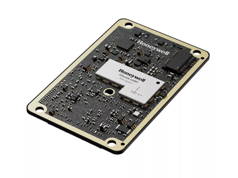
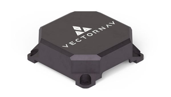
Honeywell has expanded its navigation portfolio with the HGuide o480, a high-performance, single-card inertial navigation system (INS) engineered to deliver precise, resilient localization and attitude data in a low size, weight and power package.
“The HGuide o480 is an engineering marvel and a technological breakthrough,” said Matt Picchetti, vice president, Navigation and Sensors, Honeywell Aerospace Technologies. “For the size, there are no competing products in the industry today that can achieve the same high-performance at the price point, in addition to having the ability to be augmented by the wide array of Honeywell alternative navigation capabilities to form a truly remarkable resilient navigation solution.”
The entire HGuide o480 product line is suitable for a wide range of industries, including the emerging small-factor unmanned aerial vehicles, autonomous ground and underwater vehicles, as well as an extensive range of aerial and terrestrial mapping systems for the geodetics industry.
The HGuide o480 can be integrated directly into the electronics stack of a range of applications requiring precise and robust localization. It can also reduce system size and integration complexity, enabling faster deployment and improved performance for unmanned and autonomous systems across air, land and sea. The system is fully compatible with multiple velocity aiding sensors, including the Honeywell Radar Velocity Sensor, and provides GPS-denied localization performance that is typically unavailable in similar systems.
Additionally, security is built into the fabric of the HGuide o480. Designed to perform in contested and GPS-challenged environments, the system features anti-jamming and anti-spoofing capabilities via Septentrio’s AIM+ technology included with the Mosaic global navigation satellite system (GNSS) receiver. The HGuide o480 is offered with both the triple-frequency Mosaic X5 in a single-antenna configuration and with the dual-frequency, dual-antenna Mosaic H for when GNSS attitude aiding is required. In both cases, the Mosaic delivers best-in-class real-time kinematic (RTK) GNSS performance.
The combination of ST’s Teseo chipsets with FocalPoint’s S-GNSS Auto software delivers enhanced GNSS accuracy in challenging environments
FocalPoint, a UK software company providing next-gen positioning solutions for automotive, wearables and smartphones, has announced a strategic collaboration with STMicroelectronics, a global semiconductor leader serving customers across the spectrum of electronics applications.
The joint offering provides automotive OEMs a combined solution that enhances navigation performance by improving GNSS reliability and accuracy — key to making autonomous vehicles safer.
Within this collaboration, FocalPoint will integrate its S-GNSS Auto software, powered by Supercorrelation technology, onto ST’s Teseo devices, known for their high performance and multi-constellation support. Combined with S-GNSS Auto, they will offer next-level industry-leading reliability and accuracy, surpassing other commercially available options.
GNSS is an important component in advanced driver assistance systems (ADAS), providing absolute location data. However, its accuracy is compromised in urban canyons and forested roads due to signal interference. S-GNSS Auto transforms GNSS into a reliable, high-performance sensor in these challenging scenarios. This allows automakers to harness the full potential of GNSS and confidently extend the operational range of hands-free driving beyond open-sky roads. Delivered as a simple firmware update to the Teseo device, S-GNSS Auto is cost-effective and easy to adopt.
This engagement is a significant milestone in the growth and demand for FocalPoint technology that follows a recent strategic investment from GM Ventures and collaboration with General Motors.
Key findings from the collaboration show that the combined solution of ST’s Teseo devices and FocalPoint’s S-GNSS Auto enhances measurement accuracy by up to four times and position accuracy by up to three times (in challenging multipath environments).
Contact FocalPoint at [email protected] for the full results report.
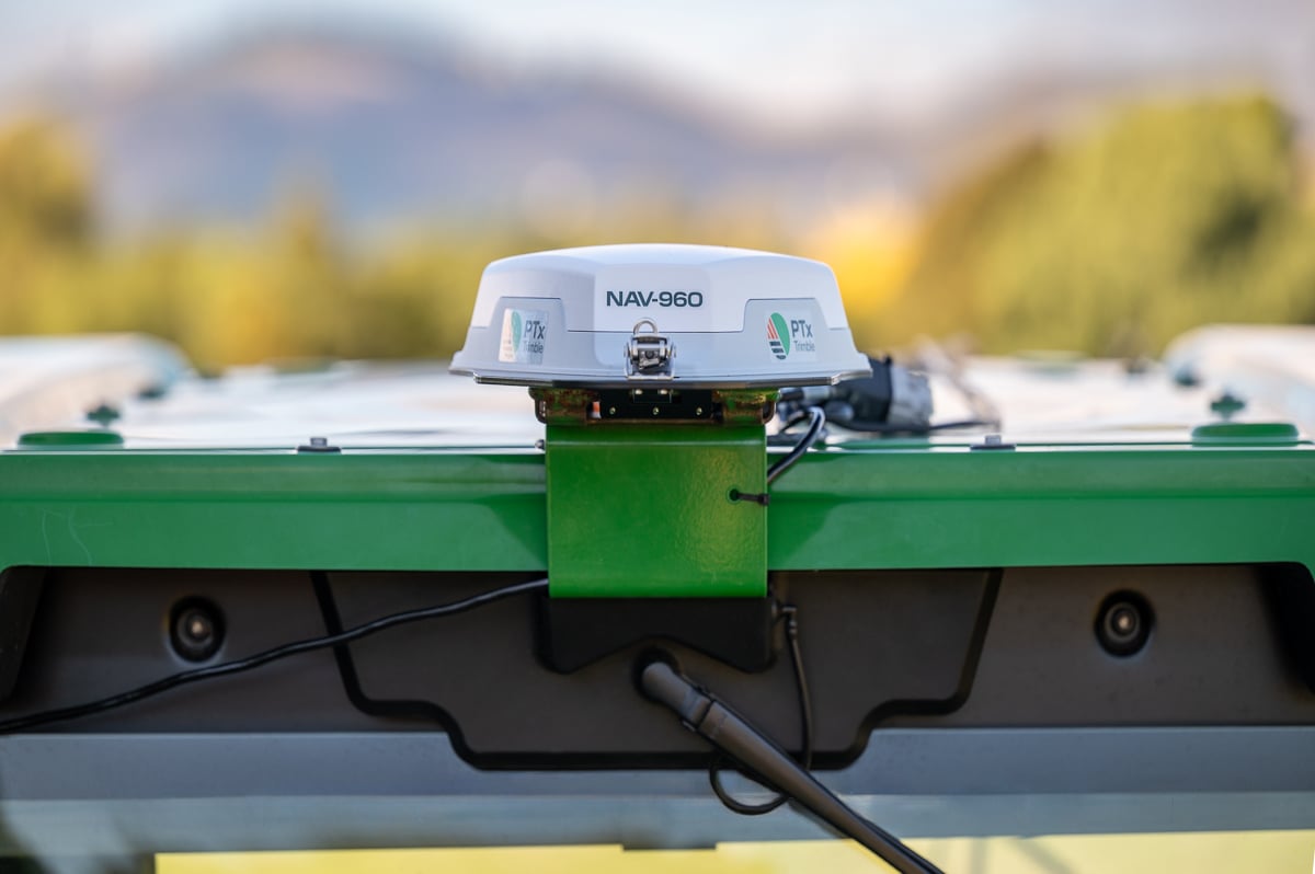
PTx Trimble, formed as a joint venture in 2024 by AGCO and Trimble, is providing a new GNSS receiver for precision autoguidance: the NAV-960 guidance controller. The agriculture controller improves positioning accuracy and availability to deliver greater uptime while providing the computing power to support complex field operations and handle future developments.
The PTx Trimble NAV-960 offers farmers an upgrade to its predecessor, the NAV-900, with a host of improvements, including enhanced speed, higher processing power and improved positioning performance. Using this receiver, farmers can handle the most complex and demanding applications for guidance and steering, creating improved uptime and the flexibility to seamlessly run field operations. This enables greater efficiency and boosts productivity.
Benefits to farmers include saving on inputs from reduced overlap and less downtime that decreases operational delays and improves machine utilization, aimed at reducing operator fatigue during long planting days and improving overall productivity. Using the NAV-960 as part of a complete autosteering solution allows operators to focus on the fieldwork as it happens and allows growers to get work done faster, reducing wear and tear on equipment.
With its cast aluminum base and sleek design, the NAV-960 is built to withstand tough farming environments, including searing heat, freezing cold, driving rain, persistent dust and everything in between. The additional processing power of the upgraded CPU ensures compatibility and readiness for fieldwork.
New features include:
Patented industrial design with rugged, dust-, water- and vibration-resistant base
Enhanced GNSS engine to track more satellites than ever before, paired with enhanced inertial sensors, provides up to 50% improved vehicle positioning and line following performance compared to the NAV-900
Onboard Trimble ProPoint® technology with Trimble IonoGuard™ for maximum resistance to downtime caused by solar events and scintillation
Centimeter-level accuracy when used in combination with Trimble CenterPoint® RTX or RTK correction signals
Advanced quad core processor for extra power, faster calculations and improved data delivery speeds
Complete compatibility with current PTx Trimble steering systems, utilizing the same cables as the NAV-900 guidance controller
Onboard Wi-Fi and Bluetooth will make the NAV-960 easier to support for service teams and ready to embrace future enhancements across the PTx Trimble solution portfolio. As part of the company’s commitment to its retrofit-first, mixed-fleet strategy, the NAV-960 is fully compatible with all GFX series displays including the GFX-350, -1060 and -1260 models.
How Farmers Benefit
Farmers who implement the new receiver will see improvements from the start, including:
Increased uptime and profitability
Reduced overlap and lower input costs
Reduced labor costs by maximizing operator effectiveness and eliminating idle time
Reduced stress and fatigue during long days in the cab, decreasing operator mistakes and errors in judgement
The NAV-960 is available worldwide, providing a solid foundation for fieldwork today and is ready to handle technology developments in the future for both aftermarket and OEM installations.
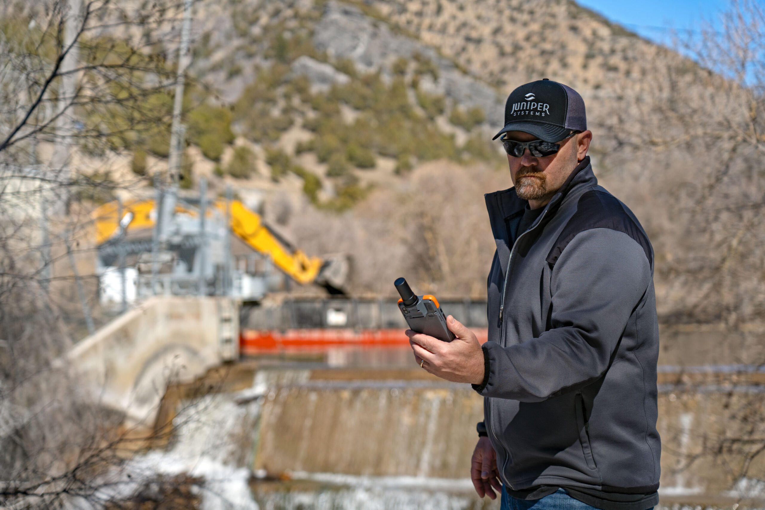
The Archer 4 with GNSS Expansion Pod and RTK connection is now an all-in-one centimeter mapping solution.
Juniper Systems Inc. announces that the GNSS Expansion Pod for the Archer 4 Rugged Handheld is now RTK capable. Juniper Systems is also launching a new application for the Archer 4 called Archer Connect. The Archer 4 with GNSS Expansion Pod and RTK connection is now an all-in-one centimeter mapping solution.
“We are very excited to bring this update to the Archer 4,” said John Florio, senior product manager at Juniper Systems. “The Archer 4 with a GNSS Expansion Pod and an RTK correction is the optimal all-in-one high-precision mapping solution.”
Archer Connect is a utility application that allows users to easily manage their GNSS expansion pod that is attached to their Archer 4. In Archer Connect, users can set up and manage their RTK network connection. Archer Connect is available on the Google Play Store.
The GNSS Expansion Pod attaches and interfaces with the Archer 4 through the Archer’s back contact pads. This allows for a compact one-handed device. The Archer 4 is a rugged handheld device designed to work in extreme environments. Featuring Android 14 and expanded battery options for increased runtimes in the field.
On March 27, the Federal Communications Commission (FCC) unanimously approved a Notice of Inquiry (NOI) to explore GPS alternatives, amid escalating threats to security and system resiliency. The move signals growing federal concern about the reliability of space-based navigation and timing infrastructure amid rising global interference and spoofing incidents.
But while the FCC’s broad consideration of alternative technologies is a welcome step forward, its framing also risks weakening one of GPS’s most important defenses: the growing adoption of multi-constellation strategies across the commercial sector.
Rising Threats, Broader Mandates
The FCC’s decision follows the release of the International Air Transport Association’s (IATA) latest safety report, which documented a 175% increase in GPS interference and a 500% rise in spoofing attacks year-over-year. These incidents pose critical challenges to aviation safety, emergency services, telecommunications, and countless other sectors that rely on Positioning, Navigation, and Timing (PNT) services.
Against this backdrop, the Commission’s vote reflects a bipartisan sense of urgency. The NOI invites public comment on a range of technologies that could serve as complements or alternatives to GPS, including low-Earth orbit (LEO) satellites, terrestrial signals, and enhanced end-user devices. This broad framing is encouraging and acknowledges the multifaceted nature of PNT resilience.
A Multi-Layered Approach to PNT
The FCC’s focus on diversification — across space-based, terrestrial, and user-level technologies — is not only prudent, but essential. Enhancing national security and system redundancy requires more than a single backup solution. It demands layered resiliency that integrates complementary modalities into a cohesive ecosystem.
It is very encouraging that the NOI outlines a wide array of candidate technologies that could play a role in improving the U.S. PNT infrastructure. These range from inertial navigation systems and time transfer services to novel terrestrial radio signals and commercial LEO constellations. By casting a wide net, the FCC opens the door to innovation and allows market forces to contribute meaningfully to PNT modernization.
Commercial Reality vs. Government Narrative
However, the FCC’s discussion notably underplays a key reality: few commercial technologies today rely solely on GPS. The commercial PNT landscape has already moved beyond single-source dependency, with the vast majority of systems integrating multiple GNSS constellations (such as GPS, Galileo, BeiDou and GLONASS) alongside additional sensor and signal data to ensure robust coverage and accuracy.
This multi-constellation approach is arguably the single most powerful tool we have to strengthen the resilience of GPS-dependent systems. By allowing receivers to pull data from multiple GNSS sources, users gain spatial and signal diversity, enabling them to cross-check signals, reject spoofed or erroneous data, and maintain accurate position and timing even in degraded environments. It’s important to remember that a device can’t selectively use GNSS networks depending on the user’s geography. If U.S. device makers disable BeiDou and GLONASS, then anywhere in the world that receiver goes it will be less performant and competitive. In recent field tests, we found that disabling the BeiDou constellation decreased a device’s positioning accuracy by 30% to 40%.
This accuracy and resilience are especially important in sectors like aviation, autonomous systems, and emergency response, where signal fidelity and redundancy can be life-saving. Multi-constellation GNSS use isn’t theoretical: it’s already the industry standard.
The International Tightrope
Despite this, key elements of the NOI, as well as comments during the meeting, reflect a growing U.S. government skepticism toward the inclusion of foreign GNSS systems, especially BeiDou and GLONASS. While geopolitical caution is understandable, overly rigid restrictions on international signals could do more harm than good.
These systems are not merely foreign-owned alternatives. They are integral components of the modern GNSS environment. Many U.S. commercial devices — ranging from smartphones to augmented reality, fleet tracking systems, drones, and more — already leverage multiple GNSS sources by default. Future technologies such as autonomous vehicles, robotics and urban air mobility will also require multiple GNSS signals to function. Prohibiting or restricting their use could mean rolling back years of progress in signal resilience, not to mention stymying future technologies, and all for a speculative and largely unquantified national security risk.
While there are some valid concerns about adversarial control over PNT infrastructure, the FCC must weigh these carefully against the real, measurable benefits of an open and interoperable GNSS ecosystem. An overcorrection risks introducing new vulnerabilities in the name of mitigating others. In reality, the more vulnerable elements of the threat surface are GNSS receivers and mobile networks, particularly 5G systems, where user location is actually determined and tracked. Unlike the largely speculative and technically unproven threats tied to adversarial GNSS constellations, there are well-documented cases of compromised receivers and nation-state exploitation of mobile infrastructure – the very reason several countries have banned Chinese 5G providers. The FCC should focus on these clear and active risks, rather than reacting to theoretical scenarios that experts argue are not technically feasible.
Innovation at Risk
There is a significant opportunity at this moment. The NOI rightly identifies emerging technologies that can enhance U.S. resiliency, including advanced chipsets, LEO-based positioning, crowd-sourced signal verification, and next-generation timekeeping tools.
However, that innovation cannot thrive in isolation. If the U.S. limits the ability of domestic systems to take full advantage of all available GNSS sources, it will undermine both resiliency and competitiveness. Even worse, it could widen the gap with foreign alternatives, especially China’s BeiDou system, which is already surpassing GPS in both accuracy and global coverage. GNSS has always thrived on multi-national cooperation and the opportunity of soft power influence. Both of which are diminished by exclusion, which is likely why there have not been bans by other countries to date.
A Path Forward
The FCC is right to prioritize this issue. It is urgent for the U.S. to build a more robust and secure PNT infrastructure in the face of these mounting threats. But its long-term success will depend on whether or not it embraces the full complexity of the PNT landscape.
This means supporting:
Open, multi-constellation GNSS access for commercial users.
A flexible, layered approach that integrates space, terrestrial, and user-level technologies.
Public-private collaboration to accelerate innovation and deployment.
Clear regulatory guidance that balances national security concerns with commercial realities.
The future of secure and reliable PNT lies not in isolating GPS, but in augmenting it through interoperability, diversity, and resilience at every layer of the system.
If the FCC’s inquiry can steer the country in that direction, it will be a pivotal moment not just for GPS, but for the entire space-based infrastructure upon which modern life depends.
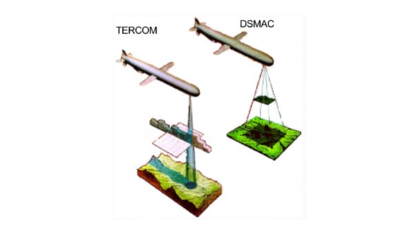
A report published in the April 7 edition of Satellite Navigation (DOI: 10.1186/s43020-025-00162-z) concludes that hybrid approaches are the most reliable solution for UAV navigation. The comprehensive review, by a research team from Prince Sultan University, evaluated 132 papers on UAV navigation in GPS-denied environments.
The research team focused on absolute and relative localization techniques including vision-based systems, lidar and terrain-aided algorithms. The review examined two primary methods for UAV navigation in GPS-denied areas:
absolute localization, which uses pre-mapped terrain data (such as TERCOM and DSMAC)
relative localization methods such as SLAM (simultaneous localization and mapping) and visual-inertial odometry that relies on real-time sensor data.
While absolute methods face limitations in featureless environments, relative techniques offer adaptability but require significant computational resources. Vision-based systems, particularly when enhanced with AI for feature recognition, hold considerable promise, though lighting conditions remain a challenge, the report concludes.
The research emphasizes the importance of sensor fusion, demonstrating that combining lidar, radar and inertial measurements – alongside advanced filtering techniques such as Kalman filters – can substantially improve navigation reliability.
Furthermore, real-time processing is crucial, with hardware accelerators like GPUs and optimized algorithms, such as LSTM networks, enabling faster data analysis and decision-making.
While hybrid systems combining terrain maps with live SLAM data offer a balance of accuracy and flexibility, the study acknowledges the need for further refinement to scale these solutions across various environments. Advancements in AI processing power and edge computing will be key to fully autonomous UAV operations in unpredictable real-world conditions.
“No single sensor or algorithm can solve all the challenges of GPS-denied navigation,” said Imen Jarraya, lead author of the study. “Our research shows that combining absolute and relative localization with multi-sensor fusion is the key to achieving reliable UAV navigation. Future work must focus on optimizing these systems to handle the unpredictability of environments ranging from dense urban areas to remote disaster zones.”
This research holds implications for industries relying on UAVs, such as logistics, agriculture, and defense, Jarraya explained. UAVs delivering medical supplies to remote or disaster-stricken areas could operate without GPS, and military drones could navigate in signal-jammed regions.
The study also points to the need for regulatory frameworks to standardize these technologies, ensuring their safe and efficient integration into future infrastructures. As UAVs become integral to smart cities and infrastructure inspection, overcoming the limitations of GPS will ensure safer, more effective operations. These findings encourage further investment in AI-driven navigation and collaborative research to refine these systems for global use.
NAL Research and VectorNav Technologies — two U.S.-based leaders in assured position, navigation, and timing (APNT) solutions — are joining forces to develop and produce Iridium STL (satellite time and location)-aided inertial navigation systems (INS) designed to meet the increasing demand for resilient PNT in GNSS-denied environments.
Both companies will be exhibiting and discussing the collaboration during the SOF Week Exposition in Tampa, Florida, May 5–8, NAL Research (#3005) and VectorNav (#1941).
Operators of uncrewed systems, in particular, can benefit from implementing an INS solution that leverages NAL’s Iridium STL-enabled APNT receivers to maintain critical operations in areas where GPS/GNSS signals are denied or degraded.
For such applications, VectorNav is leveraging its VN-210E GNSS-aided INS, which combines a tactical-grade IMU with an L1/L2 GNSS receiver in a miniature, board-mount package. Designed for maximum modularity, the VN-210E hosts VectorNav’s tightly coupled INS and includes four serial ports that enable simultaneous integration with multiple external PNT-aiding sources, such as NAL Research’s ALTM Gen2 Mini Iridium STL receiver. When paired, the system provides a high-rate and continuous position, velocity and attitude solution — even in dynamic applications and in GNSS-denied environments.
“This complete offering delivered through our high velocity collaboration with VectorNav will deliver dynamic innovation to the emerging APNT market,” said NAL Research President Robert Bills. “Our partnership streamlines our customers’ implementation of alternative APNT sources. We look forward to helping government and enterprise users achieve operational success by enabling the ability to rapidly implement highly accurate and reliable navigation solutions.”
NAL Research and VectorNav will continue to focus on co-developing product solutions that combine VectorNav’s industrial and tactical-grade INS with NAL Research’s Iridium STL receivers. Future offerings will focus on reducing SWaP-C (size, weight, power and cost), increasing environmental resilience, and supporting MIL-STD compliance for defense and aerospace applications.
“The demand for robust APNT solutions, manufactured at scale and capable of supporting dynamic autonomous systems, is growing rapidly — particularly in the critical maritime domain,” said Jakub Maslikowski, VP of business development for VectorNav. “This collaboration with NAL Research will help to realize the emerging LEO satellite PNT capability and strengthen the U.S. and allied nations’ resilience when operating in contested environments.”
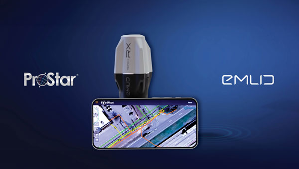
ProStar Holdings, developer of the PointMan Precision Mapping Solutions, and Emlid Tech, European maker of high-precision GNSS equipment, are partnering to bring centimeter-level precision and cost-efficiency to mapping of underground utilities and other critical infrastructure.
The strategic partnership offers ProStar’s PointMan platform, powered by Point One RTK correction services with Emlid’s lightweight and survey-grade GNSS receivers. By combining PointMan’s cloud and mobile precision-mapping solution with Emlid Reach receivers, Emlid’s end-users anywhere in the world have access to an affordable, centimeter-accurate mapping solution.
Emlid offers a range of cost-efficient and lightweight utility mapping equipment. The Emlid Reach RX is a pocket-sized high precision RTK GNSS receiver providing fast setup with no configuration required. For precision mapping trenches in challenging conditions, the Reach RS3 can be used as a base or a rover and provides centimeter-level geopositioning with tilt compensation.
PointMan with Point One RTK corrections provides an easy-to-use mobile mapping solution that uses more than 2,000 base stations communicating with all four major satellite constellations.
“We’re thrilled about this partnership,” said Dmitriy Ershov, Director of Business Development at Emlid. “PointMan mobile mapping software is well-recognized for its versatility and ease of use, and it is exciting to see PointMan continue to evolve, especially with the inclusion of Point One RTK. We are delivering survey-grade accuracy to professionals worldwide in a simple, all-in-one solution.”
Page Tucker, CEO and founder of ProStar, added, “We are strategically aligning with several leading equipment manufacturers to establish a global distribution network. Emlid’s GNSS receivers, combined with PointMan powered by Point One, create a comprehensive and affordable precision mapping solution with unmatched accuracy, coverage, and performance that empowers Emlid’s customers worldwide.”
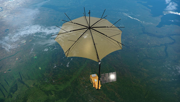
On April 29, the European forest satellite “Biomass” was launched into space from Kourou aboard a European Vega-C rocket operated by Arianespace.
The company Beyond Gravity, based in Zurich, Switzerland, supplied several key products for this mission. Its high-power antenna and navigation receiver will provide the satellite’s precise position in orbit. Also, the satellite will be protected by the company’s thermal insulation.
The European Space Agency’s (ESA) “Biomass” mission will measure forest biomass and will observe the state and development of forests and advance our knowledge of the carbon cycle. Knowing the amount of carbon bound up in forest biomass will sharpen our understanding of climate change and its likely effects on the global carbon cycle. The satellite will orbit Earth at an altitude of 666 kilometers. The mission’s expected lifetime is at least 5.5 years.
“Forests are the green lungs of our planet, providing us with oxygen and storing carbon dioxide,” said Oliver Grassmann, Executive Vice President Satellites at Beyond Gravity. “With the environmental satellite Biomass, we are learning more about the importance of forests to our climate system. Contributing to the functioning of such a groundbreaking climate satellite with key products, like various antennas, our navigation receiver and our multi-layer thermal insulation is a great honor and extremely inspiring for all our colleagues.”
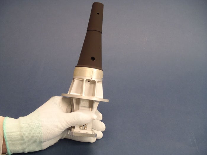
The Biomass mission will feature a new high-power antenna from Beyond Gravity that serves the data downlink needs of new Earth-observing satellites as they gather ever larger quantities of environmental data. The antenna has the size and shape of a large ice cream cone. While more and more Earth observation data from satellites is gathered, the satellite itself becomes smaller. Thus, there was a clear need for a smaller, more powerful data downlink antenna.
The X-band helix antenna design was developed for ESA by Beyond Gravity’s site in Gothenburg, Sweden. Beyond Gravity also provided the S-Band TTC (telemetry, tracking and command) antenna, which acts as a communication and control antenna for the satellite.
A new antenna from Beyond Gravity for data downlink will serve Biomass. It was developed through an ESA General Support Technology program contract with Beyond Gravity in Sweden. (Photo: ESA, Beyond Gravity)
Precise in-orbit position determination. The satellite’s position in space is determined to within centimeters using technology from Beyond Gravity’s site in Vienna, Austria. The more accurate the positioning, the more accurate the data provided by the satellite.
The receiver can process both GPS and Galileo signals. Beyond Gravity’s navigation receivers determine the position of approximately 25 satellites in space. The Beyond Gravity site in Tampere, Finland, produced the Reflector Deployment Interface Unit.
Multi-layer thermal insulation from Beyond Gravity made out of several layers of ultra-thin special polyimide foils will keep the satellite’s instruments at the required operating temperature despite the harsh thermal environment in space. Nearly every European ESA satellite is protected by thermal insulation from Beyond Gravity, which is designed and produced at the company’s sites in Austria. Beyond Gravity also produced the Eddy Current Damper, which is part of the spacecraft’s solar array wing and is providing the damping to slow down the deployment and prevent shocks at deployment completion.
In the letter, the Satellite Safety Alliance (SSA) and 93 companies and organizations stated the need for the Ligado Order to be overturned by President Trump and Congressional leadership.
“The proposed network is designed to inappropriately use spectrum reserved for satellite communications, causing significant interference to other services,” the SSA stated. Interference with GPS is a major concern of the group.
The letter urges the president and the chairs and ranking members of the House and Senate armed services and commerce committees to work with the FCC on granting petitions for reconsideration that will help prevent the building of Ligado’s terrestrial wireless network.
“Ligado’s network would threaten a wide range of critical government and commercial services, including military communications, private satellite communication, GPS, agriculture, aviation, weather forecasting, and more,” the SSA stated.
“For over two decades, Ligado and its predecessors have tried and failed to build a
terrestrial network that wouldn’t harm GPS, national security, and other critical interests,” commented the SSA. “The FCC’s Ligado Order has faced unprecedented opposition, including from 14 federal agencies and over 90 organizations representing huge swaths of the economy — from aviation and agriculture to science and manufacturing. Rarely does any issue garner
agreement from such a wide and divergent group of constituencies.”
Congress found through independent analysis that the Ligado Order poses unacceptable risks of interference to GPS, satellite communications, weather forecasting, and other services, the SSA explained. “Countless federal staff hours and resources have gone to reviewing, debating, and litigating this issue. It is past time the FCC put the issue to rest by granting the pending petitions for reconsideration.”
A roundup of recent products in the GNSS and inertial positioning industry from the January 2023 issue of GPS World magazine.
SURVEYING & MAPPING
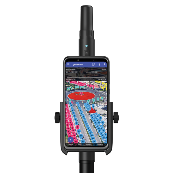
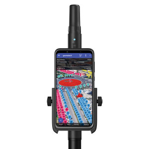
Image: Geometer International
Dual-Frequency Receiver
Receives all GNSS constellations plus SBAS
The Walker RTK is a dual-frequency GNSS receiver (L1, L2) for high-precision coordinate surveying in real-time kinematic (RTK) mode. It comes with a helical antenna, a bracket for attaching a smartphone, and the Geometer SCOUT mobile app. A classic geodesic antenna can be connected through the SMA connector. The Walker RTK has a rugged aluminum alloy casing with a shock-resistant coating, yet weighs only 250 grams. GNSS signals processed by the Walker RTK GNSS receiver include GPS (L1C/A, L2C), GLONASS (L1OF, L2OF), Galileo (E1B/C, E5b), BeiDou (B1I, B2I), QZSS (L1C/A, L1S, L2C) and SBAS (L1C/A). A built-in rechargeable battery provides 24 hours of continuous operation without recharging.
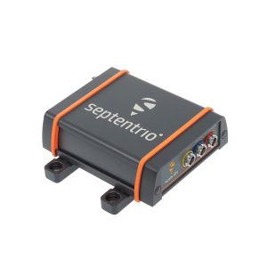
The AsteRx SB3 ProBase creates high-quality measurements for real-time kinematic (RTK) and differential corrections. The IP68-housed GNSS base station receiver features the latest quad-constellation GNSS technology and complements the SB3 receiver family: the AsteRx SB3 Pro rover receiver, the AsteRx SB3 Pro+ rover and base receiver, and the AsteRx SB3 CLAS for the Japanese market. The SB3 ProBase is easy to configure, the company says. It comes with Septentrio’s GNSS+ technologies, including anti-jam and anti-spoofing technology (AIM+) for robustness and reliability. AsteRx SB3 products are pin-to-pin compatible with the AsteRx SB ProDirect receiver and the recently released AsteRx SBi3 GNSS/INS system.
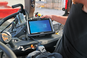
The Algiz 10XR is a rugged 10-inch Windows tablet that combines durability with a GNSS receiver and 5G communications. It was developed for challenging environments in logistics, mining, public transport, public safety, waste management or geographic information systems (GIS). The 10xR is customizable and has a dedicated multiband GNSS u-blox NEO-M8U receiver for accurate positioning as well as untethered dead-reckoning technology. The high-resolution, sunlight-readable 10-inch touchscreen has super-hardened glass and rain-and-glove mode. The tablet also has 4G/LTE high-speed data, Wi-Fi and Bluetooth.
The VZ-600i terrestrial laser scanner has a 3D position accuracy of 3 mm and less than 30 seconds of scan time for high-resolution scans with 6 mm point spacing at 10 m. This enables more than 60 scan positions per hour with real-time registration. Weighing less than 6 kg (13 pounds), the VZ-600i has a 2.2-MHZ pulse repetition rate, three internal cameras and an integrated GNSS receiver. It also includes key features to speed up workflows in indoor and outdoor applications such as architecture, engineering, construction, building information modeling, as-built surveying, forensic and crash scene investigation, archaeology and cultural heritage documentation and forestry.
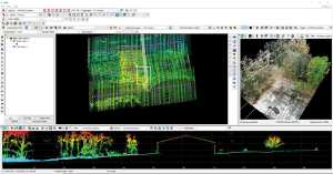
The LP360 Drone software system provides a geospatial-data workflow for UAV lidar and photogrammetry data processing. It provides powerful point cloud visualizations with multiple, synchronized windows. It can transform lidar and imagery data into survey-grade deliverables including visualization, quality checks, classification, analysis and 3D editing. For users of larger datasets, LP360 Geospatial can process captured lidar data or images from any aircraft or mobile sensor and analyze and extract values.
Free library offers data on healthcare, business, traffic
The extensive Maptitude library of free mapping databases has been updated for 2022 and is available for download, supporting insightful business development analysis. The data is available free to users of the latest version of the Maptitude mapping software. The data are also available as shapefile, KML, KMZ or GeoJSON for a fee. Maptitude includes business-critical data such as demographics, boundaries, streets, and the most ZIP Code/postal boundaries. Also available is a catalog of free premium datasets that can be used in other GIS applications, on the web, or in corporate databases.
Indoor and outdoor tracking of low-power, small IoT devices
Traxmate is integrating Nestwave GNSS location technology into its asset-tracking platform for seamless indoor and outdoor positioning, tracking and routing of small, low-power and battery-powered devices for the internet of things (IoT). Nestwave’s NestCore IP and NestCloud cloud services enable power-efficient geolocation solutions, while Traxmate (pictured) is a comprehensive data-processing hub that simplifies setup of tracking environments and provides real-time visualization of device location. The resulting geolocation solution is suitable for applications ranging from carrier tracking to tracking individual parcels and packets. Traxmate is simple to use and set up, requires no coding, and provides an out-of-the-box feature set that includes dashboards, alerts and processing rules for taking actions on incoming data. Nestwave’s trackers include ThinTrack, an ultra-low-profile, compact GPS tracking solution that integrates an LTE-M/NB-IoT modem, antenna, battery and SIM into a device that measures 82 mm x 35 mm x3 mm and weighs 15 g.
Provides guidance even without an internet connection
The Sygic GPS Navigation app uses a smartphone’s camera and augmented reality to display navigation instructions over the view ahead on the windshield. The head-up display is especially useful at night, enabling recognition of critical speed limit, road work or traffic restriction signs. Cockpit is a powerful tool that shows the real-time performance of the car, measuring the G force and actual speed to help users drive economically. The Dashcam feature records the road ahead and automatically saves the video in case of an accident. An Electric Vehicle Mode locates nearby charging stations.
Enhanced data-based rule implementation for fleets
An enhanced SureCam video telematics integration provides fleet managers with access to new capabilities to keep drivers safe and maximize fleet efficiency. The solution features a method for capturing video footage from SureCam cameras using Geotab’s powerful telematics device and rule-based system. The result is a seamless display of video within the MyGeotab platform. The enhanced SureCam fleet video solution leverages Geotab’s numerous data-based rules, such as improper seat belt usage and speeding. It uses G-force triggered alerts that detect unsafe driving behaviors and automatically captures video footage that can be reviewed later on the MyGeotab platform and alert managers to incidents when necessary. Camera configuration and customized triggers are managed directly within MyGeotab.
Driver 2.0 is a Level 4 production-ready autonomous driving solution that can operate in complex and challenging traffic environments. Demonstrations with Driver 2.0 showed an autonomous vehicle could maneuver around double-parked cars, e-scooters and pedestrians, negotiate oncoming vehicles to calculate the right timing and trajectory to pass busy intersections, and make multiple lane changes and unprotected left turns. In the case of long tail scenarios, the system will alert the remote monitoring center to intervene or take other safety measures. Driver 2.0 includes five solid-state lidar units, eight cameras and other sensors, and a computing platform integrated with a proprietary inference engine. The perception algorithm with sensor fusion can achieve precise object detection up to nearly 220 yards. The planning and control algorithm based on game theory can choose optimal routes and make decisions based on real-time situations when negotiating with oncoming vehicles and other road agents.
Provide improved signal gain for automotive antennas
Two new compounds could improve signal-gain performance compared to ceramics in second-generation automotive GNSS antennas. The new compounds — LNP Thermocomp ZKC0CXXD and LNP Thermocomp ZKC0DXXD — help enable the design and molding of antenna substrates with more complex pattern markings that add effective surface area, a critical factor in enhancing signal capture. They also provide flexibility to produce smaller parts with the same performance as ceramic, or equal-size parts with better performance. The LNP Thermocomp compounds feature electroplating capability, good thermal resistance for reliability, and the design freedom and production efficiency of thermoplastics. Both are well-suited for shark-fin-style and new conformal antenna designs.
SABIC, sabic.com
AUTONOMOUS
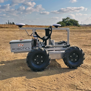
Image: Civ Robotics
Robotic Surveyor
Precisely marks thousands of coordinates per day
The CivDot unmanned ground vehicle (UGV) is designed for civil engineering and infrastructure projects such as solar farms, roadways, data centers, power plants and more. The autonomous surveying robot is designed to increase efficiency, productivity and safety on the job. Augmenting the surveyor’s work, CivDot marks thousands of coordinates per day precisely and efficiently, while delivering layouts faster than traditional methods. Civ Robotics uses Trimble’s high-precision GNSS positioning technology and surveying software.
The compact DJI Mavic 3E and 3T drones have been designed for an array of commercial missions. Flight time is 45 minutes. Both models have a real-time kinematic (RTK) module that enables surveying professionals to achieve centimeter-level accuracy with support for network RTK, custom network RTK services, and the D-RTK 2 Mobile Station. The D-RTK 2 Mobile Station is DJI’s upgraded high-precision GNSS receiver that supports all major GNSS, providing real-time differential corrections. The DJI Mavic 3E enables efficient mapping and surveying missions without the need for ground control points. The DJI Mavic 3T is engineered for aerial operations in firefighting, search and rescue, inspections and night missions.