Author: Tracy Cozzens

  • Lifesaving GPS technology aids in natural disasters

    Lifesaving GPS technology aids in natural disasters

    By Alex Damato, Acting Executive Director, GPS Innovation Alliance

    Alex Damato
    Alex Damato

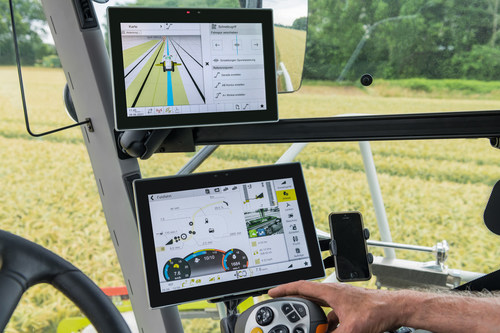
    It can be easy to take GPS for granted as the average driver and smartphone user continues to enjoy convenience, entertainment and navigation from this technology, enhancing nearly every part of our daily lives. While we may not enjoy its benefits every day, one important use case keeps us and our environment safer: GPS has become a vital part of modern emergency response.

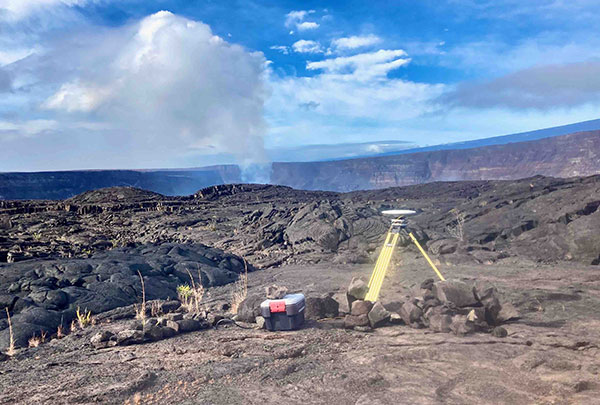
    Many Americans across the nation are preparing for the impending hurricane season or the threat of other natural disasters, such as wildfires and earthquakes. GPS will play a critical role in recovery and response efforts. When natural disasters occur, accurate and actionable location information helps save lives and restore critical infrastructure as quickly as possible.

    GPS has fundamentally improved access to information that can help the public prepare for these natural disasters, rather than waiting for them to strike. This information is more critical than ever. For example, California’s Oak fire spread to almost 20,000 acres and is part of a larger trend in California that has destroyed 14,700 buildings and killed 36 people over the past two years. Farther north, 530 wildfires in Alaska burned areas larger than the state of Connecticut in the state’s worst fire season in recent history.

    Photo: Alextov//iStock/Getty Images Plus/Getty Images
    Photo: Alextov//iStock/Getty Images Plus/Getty Images

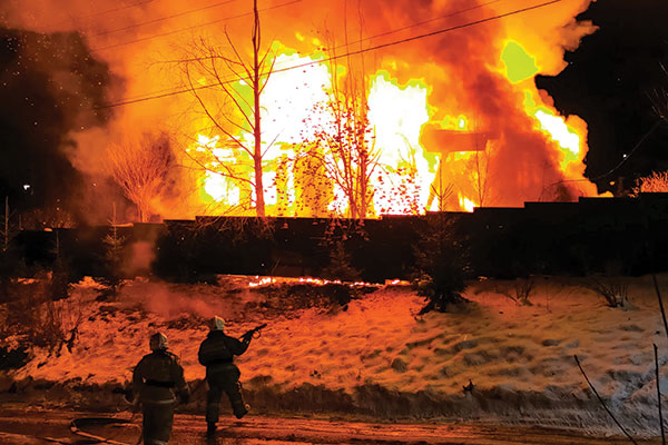
    In addition to helping the public face natural disasters, GPS helps firefighters plan their operations more efficiently and enables them to receive real-time information on the location of the wildfires they are fighting. With real-time mapping, planning and operations, fire chiefs can respond immediately to areas where wildfires are dangerously advancing.

    In turn, GPS protects our first responders by preventing firefighters from getting caught in unpredictable fires they would have otherwise not known were heading their way.

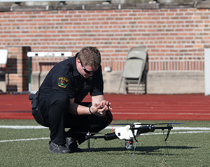
    Firefighters use IGNIS drones to help prevent wildfires from starting or safely contain them with backburns. IGNIS relies on GPS for tracking, safety and control, which in turn helps firefighters avoid the dangers associated with being near prescribed burns. Without GPS, resources to help firefighters would not be deployed as efficiently — wildfires could spread even more quickly as a result, causing even more damage to our homes and infrastructure.

    Beyond wildfires, GPS technology is critical to emergency response and weather safety. GPS data allow emergency responders to better locate callers and reduce the incidence of misrouting to outside jurisdictions. Using GPS data, a caller can be located in close proximity to his or her actual location. By reducing rates of misrouting and accurately pinpointing emergency locations, GPS helps reduce response time by taking away the need to reroute calls and search for callers’ locations.

    In a recent experiment, NASA-commissioned researchers used GPS signals to better predict a hurricane’s maximum wind speed, which could help federal agencies and forecasters better predict the danger of hurricanes and provide more actionable information to determine whether to issue evacuation orders.

    The GPS Innovation Alliance (GPSIA) is proud to support the role of GPS as a critical enabling technology for public safety, disaster response and relief efforts. With GPS, precise real-time location information is at the fingertips of both consumers and first responders from pre-disaster planning efforts to post-disaster recovery. While GPS has already fundamentally improved modern emergency response systems, GPSIA will continue to advocate for the continued growth of these lifesaving GPS-enabled technologies and applications through rigorously developed technical rules, interference protections, and a predictable spectrum environment.

    Many of us have grown accustomed to the ease of GPS-enabled technologies, from smartphone to fitness trackers. At GPSIA, we’re also particularly proud of the role GPS plays in the many other life-saving ways the technology is being used and are committed to continuing this critical work.

  • USGS upgrading Hawaiian geodetic network to monitor volcanoes

    USGS upgrading Hawaiian geodetic network to monitor volcanoes

    The Hawaiian Volcano Observatory (HVO) of the U.S. Geological Survey has been working to rebuild its geodesic monitoring network after lava consumed several GNSS stations in 2018.

    The work began following the 2018 Kīlauea lower East Rift Zone eruption and summit collapse, with funding from the Additional Supplemental Appropriations for Disaster Relief Act of 2019 (H.R. 2157).

    Teams are rebuilding and improving HVO’s geodetic monitoring network to better detect, assess and respond to volcanic hazards related to Hawaiian volcanoes. The main geodetic datasets used by HVO scientists to measure surface deformation (ground movements) are GNSS, tilt and satellite radar (InSAR) imagery.

    HVO’s geodetic network includes more than 70 GNSS stations and 15 tiltmeters on the Island of Hawai’i that continuously record and transmit data. These instruments require routine maintenance, must be upgraded periodically due to age, and must be replaced if destroyed by volcanic activity such as in 2018.

    Network upgrades include replacing out-of-date instruments and improving HVO’s network of near real-time monitoring instruments at critical areas on Kīlauea’s summit and rift zones to support early detection of magma movement and associated hazards.

    Lava takes out stations

    In 2018, lava flows destroyed three GNSS stations in the lower East Rift Zone. Another three GNSS stations were destroyed in the caldera collapses at Kīlauea’s summit.

    HVO staff rapidly deployed new GNSS stations at nearby locations to allow for continued monitoring during the eruption. These rapidly deployed sites included GNSS smart antennas mounted on surveys tripods — a setup typically only used for temporary deployments of several days to weeks.

    Many of these rapidly deployed sites were decommissioned and removed after 2018. However, 13 of them are still being used for critical monitoring and remain on temporary tripods. These sites will be upgraded and hardened using engineered fixed monuments and masts. New sites will also be installed to replace sites destroyed in 2018.

    A temporary GNSS monitoring site in the Kīlauea caldera was part of the rapid response to the December 2020 Halema‘uma‘u eruption. The site will be upgraded into a continuously operating reference station with state-of-the-art instrumentation and a hardened antenna mast. (Photo: USGS/A.P Ellis)
    A temporary GNSS monitoring site in the Kīlauea caldera was part of the rapid response to the December 2020 Halema‘uma‘u eruption. The site will be upgraded into a continuously operating reference station with state-of-the-art instrumentation and a hardened antenna mast. (Photo: USGS/A.P Ellis)

    Emergency monitoring ongoing

    GNSS receivers acquired by supplemental funds already have supported emergency monitoring of active eruptions and other volcano-related activity. Data from these instruments help HVO detect volcanic activity and inform partners at Hawai’i Volcanoes National Park (HAVO), Hawai’i County Civil Defense (HCCD) and Hawai’i Emergency Management Agency (HI EMA).

    For example, HVO rapidly deployed three new semi-continuous GNSS stations in response to the December 2020 Kīlauea eruption. These stations gave scientists a more complete view of magma returning to Kīlauea’s summit.

    Similarly, HVO deployed rapid-response GNSS equipment at two pre-existing benchmarks during the Kīlauea south caldera intrusion event in August 2021, allowing scientists to track the migration of magma from the south caldera to farther south. New instruments give HVO a more detailed understanding of and ability to monitor Kīlauea’s volcanic processes.

    HVO’s geodesy program plays a critical role in monitoring Hawaiian volcanoes. HVO’s updated geodetic network ensures that scientists can monitor changes in the shape of volcanoes, respond to eruptions, and understand magma storage and movement underground.

    “Thanks to supplemental funding, HVO is in the best position ever to leverage our state-of-the-art geodetic network to gain insights into the active volcanoes in Hawai’i, assess their hazards, issue warnings, and advance scientific understanding to reduce the impacts of volcanic eruptions,” stated Volcano Watch, HVO’s weekly newsletter.

  • Global Mapper Mobile expands GNSS device communication

    Global Mapper Mobile expands GNSS device communication

    Global Mapper Mobile version 2.3 with the Pro Module expands GNSS compatibility with TCP/IP communication and includes new field analysis tools

    Photo: Blue Marble Geographics
    Photo: Blue Marble Geographics

    Blue Marble Geographics has announced that Global Mapper Mobile version 2.3 provides additional options for connecting with GNSS receivers.

    The Global Mapper Mobile Pro Module has always included the ability to connect to external GPS devices, but version 2.3 expands this to include support for any GNSS device that uses TCP/IP communication. Additionally, this mobile update provides Global Mapper analysis tools for volume calculation and viewshed for terrain data.

    The mobile application of Global Mapper allows users to take the desktop functionality and existing data into the field for easy and accurate data collection and light processing. Since 2016, Global Mapper Mobile has been a user-friendly tool for capturing field data with portable iOS and Android mobile devices.

    Version 2.3, available in both the free and Pro versions, adds many updates and improvements to the application, including the option to record and save voice memos to vector features and add multiple field-captured images to a feature. Autosave now prevents the loss of changes made to a map.

    “Expanding user functionality in the field was the main focus of this release. Users of the base version of the application can utilize voice memos and the ability to save multiple photos to features for a more complete recording of field data,“ said Jeffrey Hatzel, Global Mapper Mobile product manager. “The Pro Module adds TCP/IP communication for external GNSS devices, expanding the list of compatible third-party devices. The addition of tools for volume calculation, viewshed analysis, and expanded projection support allows for even more workflows to be completed within the app.”

  • Juniper Systems introduces its first 10-inch rugged tablet

    Juniper Systems introduces its first 10-inch rugged tablet

    Photo: Juniper Systems
    Photo: Juniper Systems

    The new device will ship in the fourth quarter of this year and is available for pre-order 

    Juniper Systems is entering the 10-inch rugged tablet market with the launch of its Mesa Pro rugged tablet. The Mesa Pro features 11th Generation Intel Core processors, a Windows 11 operating system, device customization options, a large sunlight-readable display and “Juniper Rugged” company design.

    “We are excited to be entering the 10-inch rugged tablet segment for the first time,” said Darren Hellstern, the Mesa Pro product manager at Juniper Systems. “Mesa Pro offers powerful processing, a rugged design meant for any environment, and is a versatile workstation that can be used in the office or the field.”

    Standard Mesa Pro units come equipped with an 11th Gen Intel Core i5 processor and 16 GB of LPDDR4x RAM. Core i7 and Celeron versions of the device are also available.

    Each Mesa Pro configuration offers powerful performance and allows users to select a level of computing performance that best fits their needs while having options that meet their budgets.

    “It was important for us to offer performance tiers,” said Hellstern. “This is the first time we have offered various performance levels in one of our devices. The needs that our customers and users have varies greatly. From running CAD programs, viewing construction plans, mapping and mounted-vehicle solutions, we feel that we have an offering with Mesa Pro that fits the processing need of the user. We are also available to help users determine what level of performance they need.”

    Mesa Pro joins the current Mesa family of 7-inch devices and helps Juniper Systems achieve its mission of providing powerful rugged computing and data-collection devices to mobile field workers everywhere. The Mesa 3 runs on either Windows or Android operating systems. The Mesa family started in 2010 with the launch of the Mesa Rugged Notepad.

    “Mesa devices have served our customers for over a decade,” said Hellstern. “We are proud to add Mesa Pro to that list of incredible devices and offer more options to our customers and users around the world.”

    Juniper Systems is now accepting pre-orders for the Mesa Pro.

  • Unicore releases dual-antenna RTK module, the UM982

    Unicore releases dual-antenna RTK module, the UM982

    Photo: Unicore
    Photo: Unicore

    Unicore has released its new generation of GNSS positioning product, the UM982. The UM982 is a high-precision dual-antenna real-time kinematic (RTK) positioning and heading module supporting all constellations and all frequencies.

    The UM982 is suitable for use in UAV, precision agriculture and autonomous machine applications. The module is designed to meet the requirements of  these markets, providing technological innovation. The module supports BDS B1I/B2I/B3I, GPS L1/L2/L5, GLONASS L1/L2, Galileo E1/E5a/E5b, QZSS L1/L2/L5 and SBAS in dual-antenna mode. It offers the following advantages.

    Small size. The UM982 is highly integrated. With its size of 16.0 × 21.0 × 2.6 mm, it is a compact dual-antenna heading modules that reduces the design area of the customer’s board by 72% compared to previous modules.

    Low power consumption. Low power consumption means less energy usage and a better application experience. Lowering the power consumption while keeping performance high is one of the key technical research directions of the GNSS positioning modules. The average power consumption of all versions of the UM982 module is less than 0.6 W, which is suitable for applications that require low power consumption, such as UAVs.

    High integration. The UM982 was developed on the basis of NebulasIV, Unicore’s proprietary GNSS system on chip (SoC). NebulasIV integrates RF, baseband and high-precision algorithms on a single chip, with built-in functions providing powerful support for the UM982’s high performance.

    High precision and high performance. The GNSS SoC is a key part of the navigation system, and the performance of the chip largely determines the performance of positioning modules. High-level performance indicators include raw observation accuracy, RTK positioning accuracy, PPP positioning accuracy, and time to first fix.

    Robustness. Using the company’s dual-RTK technology, the UM982’s two antennas can independently participate in deriving an RTK solution and outputting the positioning results. This is convenient for customers conducting reliable verification in various application scenarios. By checking the RTK positioning results of both antennas, abnormal measurements in complex scenarios can be avoided.

    High reliability. A built-in, advanced anti-jamming unit provides the UM982 with strong anti-jamming ability. The module detects jamming and can output the jamming strength. It also supports digital encryption to ensure the security of data transmission, and supports multi-frequency independent acquisition and tracking to ensure the reliability and accuracy of positioning results even in complex electromagnetic environments.

  • Public-sector provider partners with NextNav for vertical location

    Public-sector provider partners with NextNav for vertical location

    Photo: LeoPatrizi/E+/Getty Images
    Photo: LeoPatrizi/E+/Getty Images

    NextNav is partnering with CentralSquare Technologies, a public-sector technology company, to integrate z-axis vertical location capabilities into its computer-aided dispatch products and mobile suite of public safety software solutions.

    CentralSquare works with more than 75% of public safety agencies nationwide, including first responders, law enforcement, fire departments, emergency medical services and local governments, equipping them with real-time data and situational awareness to decrease emergency response times.

    By tapping into NextNav’s Pinnacle network, CentralSquare will be able to provide public safety agencies with critical vertical location data needed to precisely pinpoint the location of civilians in need of assistance during an emergency.

    The integration of Pinnacle into CentralSquare’s product suite will provide users with enhanced knowledge of the most efficient routes within multi-story buildings to further reduce response times.

    “Together with NextNav, we’re helping public safety agencies meet the needs of today’s dynamic world, particularly in densely populated urban cities,” said David Zolet, CEO of CentralSquare. “Adding z-axis enables our systems to not only derive location (x-axis and y-axis) but height (z-axis). This capability is the next logical step, decreasing emergency response times and ultimately helping to protect our communities and those that serve them.”

    CentralSquare’s partnership with NextNav further establishes the company as the market leader in public safety dispatch solutions with the addition of floor-level accurate z-axis location. Once deployed, CentralSquare will deliver z-axis visualization in a 3D view, bringing visualization to their agencies and clients’ first responders. Field trials of the technology will begin towards the end of the summer, with an initial rollout anticipated in the fall.

    The Pinnacle network delivers precise vertical location in 4,400 cities and towns, covering more than 90% of buildings greater than three stories in the United States, enabling better situational awareness for first responders. Earlier this year, a tier-one wireless carrier selected NextNav Pinnacle to bring z-axis capabilities to wireless 9-1-1 phone calls to enhance caller geolocation and emergency response outcomes.

    “Expanding access to the life-saving z-axis capabilities our Pinnacle network provides is a top priority for us. Partnering with CentralSquare allows us to use this technology to positively impact the lives of the majority of public safety workers in the United States,” said Ganesh Pattabiraman, CEO and co-founder of NextNav. “CentralSquare is the largest provider for dispatch solutions signed to our ecosystem to date, bringing actionable floor-level insights to a vast number of individuals and scenarios. We’re growing our user base significantly, and along with it bolstering public safety and saving lives.”

  • Move-X offers LoRa/GNSS board with u-blox module for tracking

    Move-X offers LoRa/GNSS board with u-blox module for tracking

    Photo: Move-X
    Photo: Move-X

    Telecommunication electronics company Move-X is offering a new LoRa/GNSS board. The Cicerone LoRa/GNSS board is a high-performance, low-power, Arduino MKR-compatible development board based on the u-blox MAX-M10S GNSS module and the MAMWLE LoRa module.

    The Cicerone board delivers high-performance GNSS, long-range wireless connection, and high-performance MCU processing in a low-power solution for optimal battery life.

    The board allows users to build tracking applications worldwide with meter-level accuracy and to communicate long-range, low-power data via LoRaWAN. The integrated Li-Po charging circuit enables the Cicerone board to manage battery charging through the USB port.

    The Move-X Cicerone LoRa/GNSS board has a compact 63 x 25 mm form factor and is compatible with all Arduino MKR shield boards. These boards all share a common pinout to enable developers to easily add expansions with minimal software changes.

  • Trimble and CLAAS alliance develops precision farming system

    Trimble and CLAAS alliance develops precision farming system

    Photo: CLAAS/Trimble
    Photo: CLAAS/Trimble

    As part of a strategic alliance, Trimble and CLAAS have developed a next-generation system for CLAAS tractors, combines and forage harvesters.

    The precision farming system includes the new CLAAS CEMIS 1200 “smart” display, GPS PILOT steering system and the SAT 900 GNSS receiver.

    The CEMIS display uses Trimble’s new embedded modular software architecture for positioning, steering and ISOBUS technology for a seamless connection to control and monitor implements in the field. ISOBUS is an international communication protocol that sets the standard for agriculture electronics.

    Trimble’s new architecture accelerates the development of a customized precision agriculture system by linking CLAAS’ machine interface and Trimble’s guidance capabilities into one common in-cab user experience.

    “We understand the operators’ complexities of using separate displays with different user interfaces in the cab running the machine and performing precision farming tasks,” said Jim Chambers, vice president of Trimble Agriculture. “Working in tandem with CLAAS, we have jointly developed a next-generation precision farming system designed around one common user interface to provide CLAAS operators the best customer experience.”

    “As an experienced, innovative and global provider of precision agriculture solutions, Trimble was our first choice as a technology partner,” said Carsten Hoff, managing director, CLAAS E-Systems. “Precision farming systems from Trimble have been field proven worldwide over the course of two decades. In addition, Trimble, supported by its subsidiary Müller-Elektronik, brings outstanding expertise in ISOBUS technology, which allows a display to control the machine and implement.”

    The CEMIS 1200 display connects with the GPS PILOT system and SAT 900 GNSS receiver, based on the Trimble NAV-900 guidance controller, for positioning and steering capabilities. This solution provides sub-meter repeatable accuracy suitable for tillage, broad-acre seeding, spraying and harvest operations.

    For even greater accuracy, users can subscribe to CLAAS-branded correction services from Trimble, called SATCOR, to achieve up to 2.5 centimeter pass-to-pass accuracy without a base station.

    The precision farming system is already available for CLAAS TRION and is now expanding into LEXION, ARION, AXION and JAGUAR.

  • FAA awards $2.7M to research drone use in disasters, emergencies

    FAA awards $2.7M to research drone use in disasters, emergencies

    The U.S. Department of Transportation’s Federal Aviation Administration (FAA) has awarded $2.7 million to support research on how drones can assist in disaster preparedness and in emergencies.

    “Every second counts in an emergency, and this funding will allow drones to safely and more quickly deploy in moments when minutes matter,” said Acting FAA Administrator Billy Nolen.

    A policeman works with a drone. (Photo: FAA)
    A policeman works with a drone. (Photo: FAA)Photo:

    The research will explore the use of drones in providing effective and efficient responses to different natural and human-made disasters. It will address coordination procedures among drone operators from federal agencies as well as state and local disaster preparedness and emergency response organizations. The five universities and their award amounts are:

    • University of Vermont: $1,195,000
    • University of Alabama Huntsville: $828,070
    • New Mexico State University: $400,000
    • North Carolina State University: $200,000
    • Kansas State University: $145,000

    Today’s announcement is the third round of Alliance for System Safety of UAS through Research Excellence (ASSURE) grants, which brings the total to 20 grants valued at $21 million for Fiscal Year 2022.

    The ASSURE Center of Excellence is one of six the agency has established to help advance technology and educate the next generation of aviation professionals. Research conducted through ASSURE is focused on helping the drone community safely grow and integrate into the nation’s airspace.

    Earlier in 2022, Transportation Secretary Pete Buttigieg outlined six key Innovation Principles the department will apply when fostering transportation technologies. While continuing to commit to the highest standards of safety across technologies, these awards demonstrate the department’s commitment to exploring ways to leverage innovation to help communities and public-sector partners through experimentation.

    More than 850,000 recreational and commercial drones are in the active drone fleet, and that number is expected to grow.

  • Military exercise to test detection of GNSS disruption

    Military exercise to test detection of GNSS disruption

    DIU accelerates commercial GEOINT and NAVWAR tools and capabilities to the warfighter

    The U.S. Defense Innovation Unit (DIU) will be testing ways to mitigate disruptions to GNSS signals this fall.

    Disruptions include those from intentional sources, such as spoofing, as well as intentional or unintentional  jamming. Intentional  tactics can be applied by adversarial nation states, criminal networks or privateers.

    The shared interests between the government and private citizens alike for awareness of GPS disruptions make commercial solutions ideal; information and insight can be broadly shared not just within the U.S. Department of Defense (DOD), but across agencies, allied partners and the public as needed.

    In the Fall of 2021, the DIU launched the Harmonious Rook prototype project to address the need for scalable, persistent awareness of positioning, navigation and timing (PNT) disruptions across the globe.

    This September, the Harmonious Rook team will support the U.S. Army 1st Armored Division’s Command Post Exercise (CPX) at the National Training Center (NTC), Fort Irwin, California. The exercise is focused on large-scale combat operations (LSCO) and intended to stress the division headquarters’ ability to deploy to an austere location and command and control its units utilizing a synthetic training environment.

    U.S. and multinational maritime forces participate in SEACAT 2021. (Photo: DIU)
    U.S. and multinational maritime forces participate in SEACAT 2021. (Photo: NTC)

    Parallel to this training event is the 2nd Brigade, 1st Armored Division’s external validation exercise, also at NTC, in which the 2nd Brigade will be stressed and evaluated on its ability to deploy while contested and conduct LSCO exercises against a live opposing force.

    Several DOD and civilian agencies are participating, including the National Air and Space Intelligence Center (NASIC) and the National Space Intelligence Center (NSIC). Multiple non-traditional vendors and non-governmental organizations are also supporting Harmonious Rook, from data delivery, to machine learning analytics, to visualization and contextualization.

    Vendor Participation

    Several Harmonious Rook vendors will participate in notable DOD and international exercises. In August 2022, prototyping companies will support the Southeast Asia Cooperation and Training (SEACAT) exercise, where more than 20 Indo-Pacific countries will train and collaborate on the common goal of maritime crises and illegal activities response.

    During this multinational exercise, commercial firms will provide space-based geolocation reports and maritime analytical services, and integrate the insights into the U.S. Navy’s and Department of Transportation’s shared visualization platform, Seavision.


    DIU is also working to explore the use of publicly available PNT data to draw insight from domestic GPS interference events.


    “Mapping GPS disruptions and contextualizing patterns of behavior are key to mitigating the effects of degraded PNT as well as enabling safety of navigation under such conditions,” said Lt. Col. Nicholas Estep, Harmonious Rook program manager, USAF. “Instead of developing, building, and deploying hardware tailored for collection of navigation warfare operations, we are accessing currently available commercial data and analytics to address the need for PNT situational awareness. There are billions of GPS users and devices distributed across the world that may be adversely affected and turning the vulnerability into an advantage for discovery, classification and attribution of such malicious activity is a key aspect of this effort.”

    “The Harmonious Rook project is a very promising new approach that complements traditional collection methodologies, as it will help our customers by sharing analysis due to the unclassified and commercial nature of the data,” said Scott Feairheller, senior analyst at NSIC.

    “While the Army works diligently to acquire relevant equipment to assist in the real-time recognition and characterization of potential adversary interference, we must leverage non-organic, commercially available software and equipment, like Harmonious Rook, as a stopgap to increase awareness, seize digital key terrain and maximize lethality,” said Lt. Col. Patrick Jones of 1st Armored Division’s Space Support Element (SSE). During the exercise, capabilities will be tested to support intelligence, information operations, and command and control elements with commercial geospatial and navigation warfare awareness at the tactical level.

    DIU’s Harmonious Rook program is not limited to the DOD and the malicious activity more commonly observed overseas and in combat environments. DIU is also working to explore the use of publicly available PNT data to draw insight from domestic GPS interference events, a mission with interest from the U.S. civil agencies.

    With widespread users and subscribers that rely on PNT services, any intentional or unintentional disruption can lead to severe transportation, communication and financial implications. This highlights the importance of bringing both government and private-sector industries together to identify, attribute and mitigate GPS interference as quickly as possible.

  • Inhofe, Reed urge FCC to stay and reconsider Ligado order

    Inhofe, Reed urge FCC to stay and reconsider Ligado order

    A bipartisan group of eight U.S. senators has sent a letter to the Federal Communications Commission (FCC), urging the agency to stay and reconsider the Ligado Networks order.

    U.S. Senators Jim Inhofe (R-Okla.) and Jack Reed (D-R.I.), ranking member and chairman of the Senate Armed Services Committee, led the group in sending the letter to FCC Chairwoman Jessica Rosenworcel, urging her to reconsider granting Ligado’s license modification request.

    Ligado wants to use a part of the communications spectrum in a way that risks interference with GPS reception, a move that has been decried by many industry insiders as well as other government agencies, including the departments of Defense and Transportation.

    The timing of the letter is critical, as Ligado has announced its intention to deploy a terrestrial network as soon as Sept. 30. The National Academy of Sciences plans to release a report on the FCC’s order at a public online briefing at 11 a.m. ET Sept. 9. The report will be available at National Academies Press at that same time.

    Imminent Risks

    Joining Inhofe and Reed were Sens. Tammy Duckworth (D-Ill.), Mazie Hirono (D-Hawaii), Mark Kelly (D-Ariz.), Mike Rounds (R-S.D.), Kyrsten Sinema (D-Ariz.) and Dan Sullivan (R-Alaska).

    The senators write: “Staying and reconsidering the Ligado Order is necessary to address the imminent risks associated with Ligado’s intention to ‘commence operations in the 1526-1536 Mhz band on or after September 30, 2022.’ We remain gravely concerned that the Ligado Order fails to adequately protect adjacent band operations — including those related to GPS and satellite communications — from harmful interference impacting countless military and commercial activities.

    “We urge you to set aside the Ligado Order and give proper consideration to the widely held concerns across the Executive Branch, within Congress, and from the private sector regarding the expected impact of the Ligado Order on national security and other systems,” the senators continued.

    A copy of the letter can be found here and below.

    Dear Chairwoman Rosenworcel:

    We write to you today to urge the Federal Communications Commission (FCC) to stay and reconsider the FCC’s order granting the applications of Ligado Networks LLC (Ligado) to deploy a terrestrial wireless network in the L-band satellite spectrum neighborhood, FCC 20-48, adopted April 19, 2020 (the Ligado Order). We remain extremely concerned that terrestrial L-band operations would cause unacceptable risk to Department of Defense (DOD), the Federal Government Global Positioning System (GPS), and Satellite Communications (SATCOM) operations.

    Prior to the issuance of the Ligado Order, fourteen federal agencies and departments expressed strong opposition to the applications sought by Ligado over concerns about potential harmful interference with GPS operations. In May 2020, shortly following the issuance of the Ligado Order, on behalf of the executive branch, the National Telecommunications and Information Administration (NTIA) petitioned the FCC to reconsider its decision. That filing requested that the FCC “rescind its approval of the mobile satellite service (MSS) license modification applications” granted to Ligado, which the NTIA asserted would “cause irreparable harms” to federal government GPS users.

    Staying and reconsidering the Ligado Order is necessary to address the imminent risks associated with Ligado’s intention to “commence operations in the 1526-1536 Mhz band on or after September 30, 2022.” We remain gravely concerned that the Ligado Order fails to adequately protect adjacent band operations—including those related to GPS and satellite communications—from harmful interference impacting countless military and commercial activities. We urge you to set aside the Ligado Order and give proper consideration to the widely held concerns across the Executive Branch, within Congress, and from the private sector regarding the expected impact of the Ligado Order on national security and other systems.

    We look forward to continuing to work with you to ensure that federal spectrum policy adequately protects the millions of military and commercial users who rely on L-band satellite services every day.

    Feature photo: Brian Kinney/Shutterstock.com

  • Details of September’s CGSIC meeting released, DeLaPena to speak

    Details of September’s CGSIC meeting released, DeLaPena to speak

    The 62nd meeting of the U.S. government’s Civil GPS Service Interface Committee (CGSIC) will be held Sept. 19–20 in the Hyatt Regency Denver at the Colorado Convention Center, before the annual ION GNSS+ conference.

    It will be hosted by the U.S. Department of Transportation (DOT) and the U.S. Coast Guard Navigation Center (NAVCEN). DOT serves as the civil lead for GPS and chairs the CGSIC in this capacity. NAVCEN is assigned duties as Deputy Chair and Executive Secretariat for the CGSIC.

    On Sept. 19, the CGSIC subcommittees for Timing, International Information, and Survey, Mapping, and Geosciences will meet. A summary of these meetings will be presented to the CGSIC Plenary Session on Sept. 20.

    Photo:
    Cordell DeLaPena, Program Executive Officer for Military Communications and PNT Space Systems Command

    Keynote speaker for the plenary session is Cordell DeLaPena, program executive officer for Military Communications and Positioning, Navigation, and Timing, Space Systems Command, Los Angeles Air Force Base.

    The agendas for the CGSIC subcommittee and plenary sessions will include presentations on the operational status and modernization of the GPS constellation of satellites, U.S. space-based positioning, navigation and timing (PNT) policy, GPS augmentation systems, and information related to U.S. engagement with other international GNSS as well as a variety of interesting applications of the use of GPS.

    Several new briefings are part of the plenary session this year, including a presentation from NASA on the role of GPS in support of the next lunar mission. Also, the Department of Homeland Security will provide an update on the activities of the Office of Infrastructure Protection, Positioning, Navigation, and Timing Program Management Office.

    This year’s meeting will be live-streamed over the internet. For those who are unable to travel, the meetings can be accessed with the links below.

    The agenda for the meeting is available; all CGSIC presentations will be available there for viewing online shortly after the meeting ends. As a reminder, all CGSIC meetings are free and open to the public.

    Surveying, Mapping and Geo-Sciences Subcommittee
    Sept. 19, 9 a.m. – 12:30 p.m. MDT
    Chair: John Galetzka, NGS
    Co-Chair: Neill Winn, NPS

    https://vimeo.com/event/2298510/f73d8f14a5

    International Information Subcommittee
    2–5 p.m. MDT
    Chair: John Wilde, CEO, Spacekeys

    https://vimeo.com/732131682/cc3618c8f4

    Timing Subcommittee
    2–5 p.m. MDT
    Chair: Patricia Larkoski, The MITRE Corporation
    Co-Chair: Bijunath Patla, NIST

    https://vimeo.com/732129866/117e64cded

    Plenary Session
    Sept. 20, 9 a.m. – 5 p.m.
    Chair: Karen Van Dyke, DOT
    Deputy Chair: Cpt. Scott Calhoun, USCG

    https://vimeo.com/event/2298510/f73d8f14a5