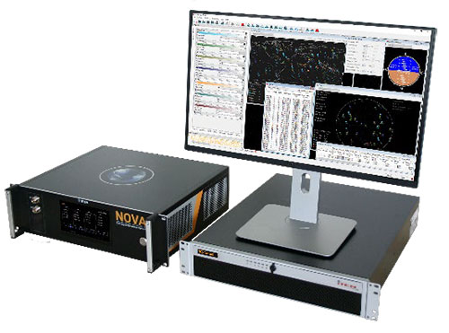
IFEN GmbH has released a new version of its NCS Nova RF signal simulator, offering a full package of advanced simulation capabilities.
With its now-integrated interference generation capability (AWGN, CW, pulsed and chirp), NCS Nova version 2.8 can generate coherent interference signals with a signal power of up to –30 dBm.
The ability to assign two users to one RF output enables integrated spoofing scenarios with a single RF output (one user is the original simulated user; the other is the target spoofing user). Thus, spoofing is available even with an entry-level single RF Nova.
The key feature of this new release is the new navigation message authentication (NMA) simulation capability, compliant to User ICD 1.0 for the Galileo E1-B OSNMA. Beyond basic authentication-testing capability, specific OSNMA events can be simulated. Testing OSNMA-enabled receivers under these specific events is key to ensuring compliant receiver behavior. The supported events include both a public key renewal and revocation and TESLA keychain renewal and revocation. Also, GPS cross-authentication is fully supported.
Finally, the new release fully supports generation of Galileo E6-C encrypted codes. This enables users to take full advantage of the Galileo third-frequency pilot signal.
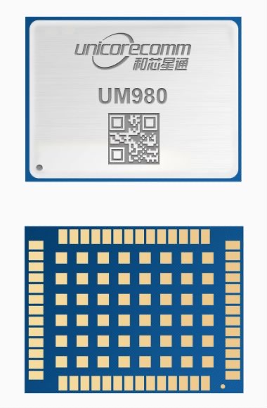
Unicore Communications has released its new generation of high-precision GNSS module. The UM980 uses real-time kinematic (RTK) technology to achieve centimeter-level positioning accuracy.
The UM980 is based on the small high-performance system-on-chip NebulasIV, which integrates radio frequency, baseband and high-precision algorithms on a single chip. It has 1,408 channels to concurrently receive satellite signals from multiple constellations and multiple frequencies.
The UM980 module can track BDS B1I/B2I/B3I/B1C/B2a/B2b, GPS L1/L2/L5, GLONASS L1/L2, Galileo E1/E5a/E5b/E6 and QZSS L1/L2/L5, as well as supporting SBAS.
Its advanced multi-mode multi-frequency computing engine provides powerful signal processing ability, characterized by fast initialization time, accurate positioning results, and a high data-update rate of up to 20 Hz.
The UM980 features low power consumption, typically 480 mW. The module is a surface mount device (SMD) measuring 17 x 22 x 2.6 millimeters. Compared to Unicore’s previous generation of high-precision GNSS modules, the UM980 is nearly half the size while the performance remains excellent.
The UM980’s compact form occupies less printed-circuit-board area and makes the product more portable. The UM980 is also equipped with an advanced anti-jamming unit, which ensures high reliability even in complex electromagnetic environments.
Thanks to its high precision, high performance and high reliability, UM980 is suitable for applications in surveying, mapping and precision agriculture. The UM980 is qualified according to the international quality standards (RoHS, REACH, CE, FCC, and IC) and is in mass production.
The company tested Driver 2.0, a Level 4 production-ready autonomous driving solution
New video highlights navigating heavy traffic safely and efficiently
Photo: DeepRoute.ai
DeepRoute.ai, an international autonomous driving technology company, has announced the results of its latest fully driverless test of its Driver 2.0 Level 4 production-ready autonomous driving solution.
DeepRoute.ai released a video exhibiting a driverless vehicle retrofitted with the solution on Central Business District roads in Shenzhen, demonstrating its advanced capacity in complex and challenging traffic environments. It was the first legal driverless test in China — Shenzhen unveiled China’s first regulation on intelligent connected vehicles on July 6.
The fully driverless vehicle drove just under 14 miles in one hour, navigating through significant traffic and narrow lanes safely and efficiently. The vehicle:
intelligently maneuvered around double-parked cars and counterflow e-scooters and pedestrians
negotiated with oncoming vehicles to calculate the right timing and trajectory to pass busy intersections
conducted multiple lane changes and unprotected left turns.
“The recent legislation permitting driverless robotaxis in Shenzhen is the first of its kind, a major milestone in advancing autonomous driving technology to wider and faster adoption,” said Maxwell Zhou, CEO of DeepRoute.ai. “As we advance our mission for commercial deployment of autonomous driving vehicles, we will collaborate with automakers to refine our L4 solution to make it as safe and efficient as possible.”
DeepRoute.ai has made significant improvements to achieve driverless capability, with both software and hardware meeting auto-grade standards. The safety mechanism was also upgraded to guarantee driverless safety on the road. In the case of long tail scenarios, the system will alert the remote monitoring center to intervene or take other safety measures.
The Driver 2.0 System
Driver 2.0 includes five solid-state lidar units, eight cameras and other sensors, and a computing platform integrated with its proprietary inference engine. The perception algorithm with sensor fusion can achieve precise object detection up to nearly 220 yards. The planning and control algorithm based on game theory can choose optimal routes and make decisions based on real-time situations when negotiating with oncoming vehicles and other road agents.
With its deep learning approach, the inference engine optimizes compute resources, allowing the algorithm to run on its low-cost and power-efficient computing platform effectively and stably. As a result, Driver 2.0 can be priced at $3,000 for automakers in mass production and the algorithm can work with 2 to 5 solid-state lidars for automakers’ customization needs.
The latest legal and regulatory framework is aligned with autonomous-driving industry developments and is considered the prelude to mass production and commercialization of autonomous-driving vehicles. DeepRoute.ai is working with automakers to mass produce consumer vehicles integrated with Driver 2.0, expected to be available for consumer purchase in 2025. It is also being integrated into robotaxi operations.
DroneShield’s RfPatrol MKII body-worn system antennas. (Photo: DroneShield)
DroneShield has received and delivered upon a follow-on order by a U.S. government agency for the company’s portable and handheld counter-UAS (C-UAS) solutions.
DroneShield is the maker of the counter-drone or anti-drone systems including RfPatrol and DroneGun MkIII. It has received contracts from the U.S. departments of Defense and Homeland Security, as well as other federal and state law enforcement agencies.
“We’re grateful for the continued trust that this organization has placed in us to help address a unique set of operational challenges. Our customer relationships are what fuel our commitment to push the boundaries of what’s possible in the counter unmanned space,” said Tom Branstetter, director of business development, DroneShield. “Every teammate at DroneShield understands the significance of the problems we’re solving for our end-users and it’s something we’re proud to support.”
DroneShield also recently announced deployments of its solutions for high-profile events including the World Economic Forum (WEF) in Davos, Switzerland, and IRONMAN Texas 2022.
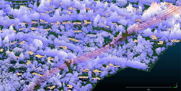
Teren, a climate resilience analytics company, has expanded its Premium 4D Content program for regions across the United States, including the Gulf Coast, Midwest, Rocky Mountains and West Coast.
Teren acquires and quickly processes high-fidelity lidar data, making it available via its content library, and delivers analytics with actionable insights to energy and engineering firms.
“Climate change is causing drought, flooding, landslides and wildfires across the country – significantly impacting asset owners and project developers. As a result, the market demand for high-fidelity, temporal data to identify, prioritize, and monitor climate-related risk is higher than ever,” said Toby Kraft, Teren CEO.
Teren is amassing a content library of remotely-sensed 3D (spatial) data across the United States. That data is updated on regular intervals to monitor changes over time providing a unique 4D (temporal) view. This 4D data library feeds analytics that identify risk, inform mitigation, and strengthen asset resilience. While remotely-sensed data has traditionally been sourced on a project-by-project basis, Teren offers its data and analytics as a subscription service. This model drives down the costs for clients and stakeholders, helping to maximize the speed of delivery, return on investment, and data value.
“In our flagship content region, Appalachia, our customers tap into our 4D content library to identify and monitor the terrain and surface conditions surrounding their assets — primarily aiming to identify and mitigate landslides before they become catastrophic incidents,” Kraft said. “We’re expanding the program nationwide to meet the growing demand for terrain monitoring and climate resilience analytics around events such as erosion, flooding, wildfires and more.”
Teren’s solution saved clients in Appalachia an estimated $152 million annually, preventing 24 failures per year due to landslides. While landslides are not as pervasive across the United States, companies can apply the data and analytics suite for the following:
Gulf Coast: inundation, subsidence, land movement
Midwest: erosion, flooding, subsidence
Rock Mountains: landslides, flooding, wildfire
West Coast: wildfires, land movement, flooding.
Traditionally used by the energy sector, Teren’s data has also proven to be highly valuable to state and federal agencies, insurers and civil engineers. Teren expects to see increased variability across clients and use cases as the content region expands.
To learn more about Teren or to request a demo, visit www.teren4d.com.
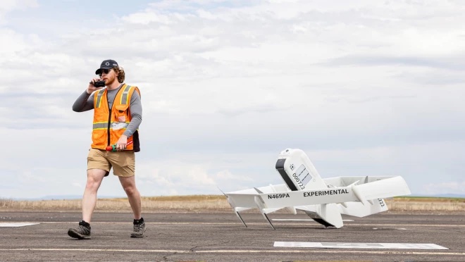
Amazon has put out a video to show how the company is building its drone delivery service. The fully electric drones are designed to deliver packages under 5 pounds to customers in less than 60 minutes.
Later this year, customers living in Lockeford, California and College Station, Texas will be among the first to receive Prime Air drone deliveries.
Three components are integral to the system:
The drone itself, which Amazon said is as robust and reliable as its ground transportation trucks.
A sense-and-avoid system for obstacles such as other aircraft, people and pets in backyards.
An automated drone-management system to plan flight paths and ensure safe distances between the drones and other aircraft in the area, and ensure compliance with aviation regulations.
Amazon has been developing its drone delivery system for almost a decade, employing experts in safety, aerospace, science, robotics, software, hardware, testing and manufacturing.
Below is an inside look at an Amazon flight-testing facility in Oregon.
Trimble has introduced data integrity monitoring for CenterPoint RTX Fast, its precise point positioning (PPP) correction service.
The Trimble RTX Integrity monitoring system is an innovative, patented solution, built in direct response to client requirements for production-ready applications. It continuously validates the reliability of correction data processed by the network, which is broadcast to users in the agriculture, geospatial, construction and automotive industries, ensuring positioning data is right the first time.
Through a two-step process, the Trimble RTX Integrity system verifies the integrity of GNSS data and filters faulty information in the network server before the data is broadcast. A secondary post-broadcast check is conducted on the entire data transmission process where additional errors may be detected and removed.
The integrity monitoring system is fully automated and reacts in seconds to detect, isolate and block faulty data to provide even more highly accurate and reliable positioning.
Trimble RTX Integrity is comprised of independent monitoring stations strategically positioned across RTX Fast networks in the United States, southern Canada and across Europe. These stations continuously monitor data output during multiple stages of the Trimble RTX positioning process. Any suspicious satellite data is removed during the integrity protection process and positioning is calculated using only validated data.
Trimble Alloy GNSS reference receivers power the independent monitoring stations using redundant internet connectivity for added reliability. To date, no other positioning network offers the same level of data integrity validation across such expansive, contiguous geographies.
Trimble RTX Integrity monitoring system was developed in accordance with Automotive Software Performance Improvement and Capability dEtermination (ASPICE) and ISO 26262 automotive safety standards, making it easy to integrate into major automotive manufacturers’ autonomous driving systems.
Trimble RTX Integrity can also be used by Trimble’s customers in the agriculture, geospatial and construction industries to ensure correction stream integrity and reliability for applications such as machine control and high-accuracy surveying applications.
“Trimble remains committed to exceeding expectations by providing accurate corrections to our customers to support safety-critical and other day-to-day applications,” said Patricia Boothe, SVP of autonomy, Trimble. “Implementing additional checks and balances to ensure our data is authenticated, trustworthy and accurate is of paramount importance to maintaining the integrity of our RTX network and instilling confidence with our users that the data is correct.”
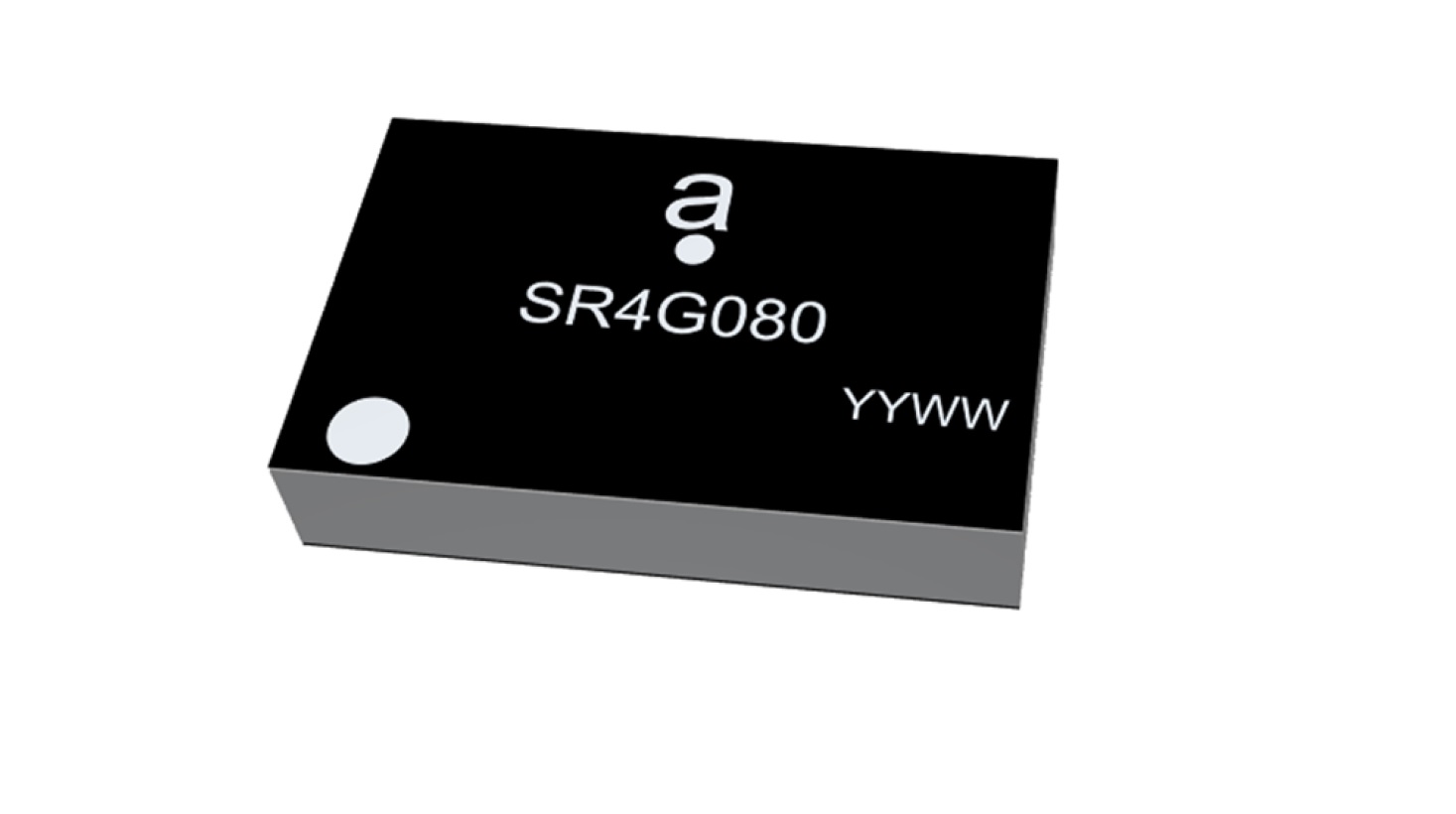
Antenova Ltd. is adding a new offering to its range of miniature surface-mount-designed (SMD) antennas and modules for GNSS applications. The new antenna, Agosti (part number SR4G080), measures 9.0 x 5.8 x 1.7 mm and operates with exceptional efficiency in a reduced space on a corner of a printed circuit board (PCB).
The key advantage of the Agosti antenna is its small ground-plane requirement. Most SMD antennas use the surface of the PCB around the antenna as a ground plane from which to radiate the signal — the ground-plane requirement, not the physical dimensions of the antenna, define the space it needs.
Antenova’s radiated measurement results show Agosti operating well on small ground planes of 40 x 20 mm, 70 x 25 mm and 80 x 30 mm, making it a suitable choice for small form-factor designs, such as small wearable devices, trackers and on-board diagnostics (OBDs).
Agosti is designed to integrate and co-exist with other antennas within the same device. OBDs and trackers often use 4G/LTE with A-GPS for fallback. The Agosti antenna has been tested with Antenova’s Pharoah antenna (part number SR4L073), which also has a very small ground-plane requirement. The two antennas have excellent isolation and can operate in close proximity to each other in a very small device without the 4G signal interfering with sensitive GNSS signals.
“Small SMD antennas such as Agosti are an exciting alternative to the common delicate ceramic patch antennas used in GNSS designs,” said Michael Castle, product marketing manager, Antenova. “This is not just because the SMD antennas are significantly smaller. It is also because they provide omni-directional performance.
“Patch antennas are typically 12 mm or 14 mm square, are heavier than SMD antennas, and need a much larger ground plane and keep-out area,” Castle said. “They also have to be placed in the center of a circuit board and only work well when they point at the sky. Antenova’s new generation of SMD antennas overcome all of these limitations and perform well regardless of position and orientation of the device.”
Tesla has applied to patent a new multi-band GNSS antenna with increased precision for self-driving and navigation in its autos, reports electrek. The antenna would be positioned inside the rear-mirror enclosure, and the system would also provide a heating element.
While increasing precision, it is also designed to reduce power demand, noise and cost.
The automaker describes the new device in the abstract of the new patent application:
A multi-band antenna system is provided. The antenna system can be placed under and embedded within a glass exterior surface of a vehicle. Such an antenna system can include a capacitively coupled metallic element on or adjacent to the glass exterior surface, which can serve as both a parasitic element to enhance gain and as a heating element to melt snow and/or ice accumulation over the glass area that covers the antenna. In certain applications, the antenna’s structure itself can be used as a heater to improve performance in adverse weather conditions while the heating elements are positioned away from the thermally sensitive electronics. The antenna system with integrated heating can include a spiral antenna.
A diagram of the antenna provided with the patent application. (U.S. Patent Office)
Xona Space Systems, a company developing navigation technologies from low-Earth orbit (LEO), has received investment backing from numerous companies, including Lockheed Martin. Its latest financing round was oversubscribed, bringing the start-up’s total funding to more than $25 million.
Xona is developing a high-performance commercial satellite navigation network, named Pulsar. Pulsar is a LEO system designed to provide resilient and trusted centimeter-level position anywhere on the globe.
Within the past year, Xona more than doubled its number of full-time employees, launched its first orbital mission, and signed agreements with major players across the GPS/GNSS ecosystem such as Hexagon | NovAtel and Spirent Federal.
Image: Xona Space Systems
The funding round was led by First Spark Ventures, who is joined by numerous new investors including Lockheed Martin Ventures, SRI Ventures (of SRI International), Velvet Sea Ventures, Gaingels, Airstream Venture Partners and Space VC. Existing investors also continue to show firm conviction in Xona’s accomplishments and market opportunity with participation from Seraphim Space, Toyota Ventures, 1517 Fund, MaC Venture Capital and Stellar Ventures.
The new capital will accelerate development of Pulsar through several critical design milestones by expanding the team and building out Xona’s new R&D and manufacturing facility in Burlingame, California. This will enable more rapid design cycles and prepare for production.
Xona’s first demonstration mission, Huginn, was successfully launched in May, and its second mission, Muninn, is planned to launch in 2023.
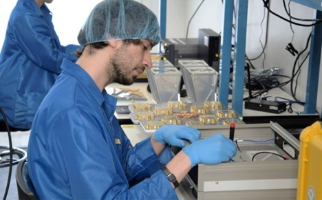
Xona Engineer Nick Manglaviti setting up hardware-in-the-loop testing at Xona’s R&D lab in San Mateo, California. (Photo: Xona Space Systems)
“Xona’s approach to GNSS is poised to enable a whole new class of robust and reliable solutions in everything from automotive to drones,” said Manish Kothari, managing director of First Spark. “This is a technically challenging problem — a problem the Xona team is uniquely qualified and experienced to address. We are very excited to be part of this journey with them.”
Xona’s core mission is to enable modern technology to operate safely in any environment, anywhere on Earth. To achieve this in industries such as automotive autonomy, drones and aerial mobility, precise knowledge of location and time is critical, and it must be robust against sources of potential interference or degradation. This is driving a need for global infrastructure that can support the demands of these applications as they continue to expand in both capability and geography.
“The massive domain expertise of our supporters in everything from scaling global companies to deep technical knowledge of GNSS is both a validation of our team’s capabilities and a catalyst that has been instrumental in our growth and speed,” said Xona CEO Brian Manning.
“As customer needs evolve, Lockheed Martin Ventures continues to work with companies we believe are on the forefront of emerging technology and that support increasingly resilient, hybrid systems,” said Chris Moran, vice president and general manager of Lockheed Martin Ventures. “We invested in Xona so they can continue to develop and build their commercial system to complement the greater GNSS architecture.”
“The world would look very different today without GPS,” said Xona CTO Tyler Reid. “The ubiquitous robust precision that Pulsar can provide has potential to make the same level of global impact, not only in present and emerging markets, but we believe this global high precision can also enable entirely new devices and apps that we haven’t even thought of yet.”
USSF Lt Col Robert Wray takes command of 2SOPS. (Photo: USSF/Dennis Rogers)
The 2nd Space Operations Squadron (2 SOPS), which oversees the GPS constellation, now has a new leader. Outgoing U.S. Space Force (USSF) Lt. Col. Michael Schriever relinquished command of the unit to USSF Lt. Col. Robert Wray.
The squadron conducted a change of command ceremony at Schriever Space Force Base, Colorado, on July 6, officiated by Space Delta 8 Commander Col. Matthew Holston.
As the new commander, Wray assumes the responsibility of overseeing the daily operations of a unit whose mission is to operate the GPS constellation, which provides global navigation, time transfer, and nuclear detonation detection.
Col. Matthew Holston honors Lt. Col. Michael Schriver for his 2SOPS service. (Photo: USSF/Dennis Rogers)
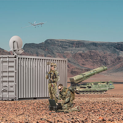
Focus Telecom has introduced a new timing product for defense and mission-critical applications, the Time-Loader.
The Time-Loader can be deployed in environments where GNSS signals are denied or disrupted, to support any ground, naval and airborne system that needs real time of day (TOD) and 1PPS external synchronization aligned to UTC or GNSS.
In this emerging era of rapid tactical deployment of defense systems, communications intelligence, missile defense systems, radar/electro-optical sensors and UAS batteries in the field are often in GNSS-denied or jammed environments. This situation creates challenges for access to real time and accurate time of day.
To solve this problem, the Time-Loader generates a GPS L1 C/A code RF output as if the signal were coming from a live-sky GPS antenna. It provides full-constellation GPS output and is compatible with external GNSS receivers. It encodes times with nanosecond accuracy for GPS timing receivers.
The Time-Loader’s GPS-disciplined oscillator (GPSDO) is the Microsemi MAC-SA53/55, which provides excellent UTC accuracy with outstanding hold-over rubidium clock performance.
The Time-Loader is the size of a suitcase, hand-carried and easily deployed. It activates quickly from a cold start or when sensors are deployed for the first time.
Included in the Time-Loader is a self-contained, miniature GPS simulator that provides real-time extremely accurate signals. The 18-channel full-constellation simulator stores location/time/date data in internal memory and stores complex vector data to simulate dynamic scenarios. The simulator also can be used to transcode NMEA or SCPI position/velocity/time (PVT) data into GPS RF signals.