What role do artificial intelligence (AI) and machine learning (ML) play in analyzing GNSS signals? How might that evolve?
Ellen Hall
“ML is gaining adoption across many GNSS application areas due to its ability to extract data and classify signal information often within complex operational environments. By combining ML with AI, systems are now able to characterize receiver correlator outputs and ranging residuals, and then fuse this with identified environmental features — all potentially increasing GNSS accuracy, integrity and availability. As AI and ML mature, we can expect to see new novel methods to optimize PNT sensor-fusion engines. This will include the combination of GNSS signals with other sensor signals such as inertial and vision.”
— Ellen Hall
Spirent Federal Systems
Bernard Gruber
“AI will come to the battlefield and I would like to think that AI and ML will play a large part in GNSS solutions and specifically protection from adversaries in the future. As AI can ‘anticipate’ threats (i.e., spoofing, jamming, poor coverage) based upon what it sees and knows one should be able to reduce the cycle time to combat that threat (e.g., find/fix/identify and then target, change frequencies, evade). Seeing this data, ML can adapt to morphing threats as well as ‘fuse’ data from all different domains (air, space, sea and land) to provide solutions.”
— Bernard Gruber
Northrop Grumman
Jules McNeff
“I would like to turn the question around and ask ‘How does GNSS contribute to enabling AI and ML to function in physical space?’ Many AI and ML experts don’t think about this aspect of the technologies. Of course, timing is essential to AI and ML operation, but both must be spatially oriented as well if they are to interact effectively with things in the ‘real world.’ The more complex the interactions, the higher the need for precise, continuous PNT information. Depending on the applications, the relationships can become synergistic.”
— Jules McNeff Overlook Systems Technologies
Greg Turetzky
“AI and ML have a great opportunity to fundamentally change the way GNSS signals are used for positioning. In particular, the new modernized signals with wider bandwidths and higher chipping rates create a fundamentally richer data set than classic range/range rate measurements. By analyzing the channel response and using AI/ML techniques, the entire signal environment of LOS and NLOS signals can all be used to make more accurate measurements. In fact, in deep urban canyons with appropriate training, it is even possible to accurately position using only multipath signals such that more multipath makes the position more accurate, not less.”
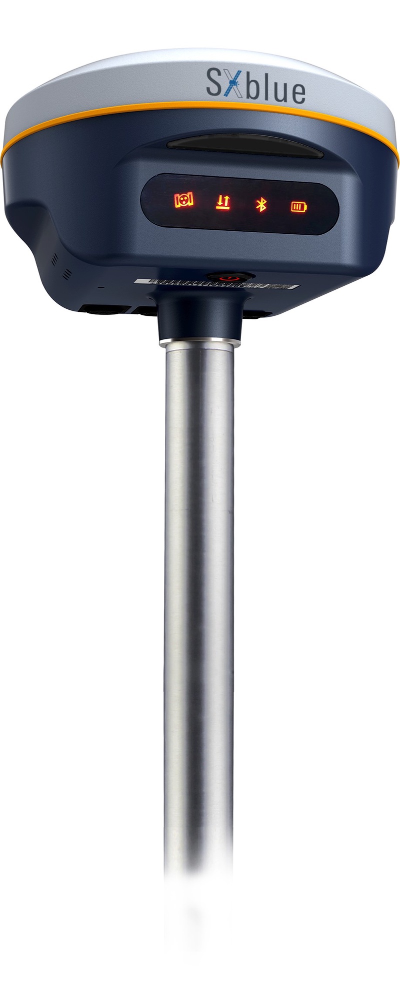
Geneq Inc. has released the SXblue SMART to meet the requirements of professionals looking for an accurate, flexible smart antenna for field work.
The SXblue SMART features a GNSS engine capable of quickly tracking all-in-view GNSS signals. Its design includes interference mitigation technology and optimization for handling a wide frequency band.
Weighing 850 g including battery, the SXblue SMART is compact, supplying the accuracy, ruggedness and maneuverability needed by surveying professionals. Its radio link is based on the Farlink protocol that allows a range of up to 8 km, a performance achievable while reserving a wide bandwidth for transmission of real-time kinematic (RTK) data.
In addition to a tilt sensor for measurements in hard-to-reach places, the SXblue SMART features a high-performance attitude measurement module that can detect and measure movement of the device. An integrated inertial measurement unit provides even more accurate and stable measurements and increased productivity. The SXblue SMART also has a built-in thermometer for monitoring and controlling its internal temperature.
Compared to the company’s previous products, the SXblue SMART has improved communication features, including near-field communication that facilitates close communication with a controller or mobile phone equipped with this technology.
A demonstration airspace management system is playing a role during the military exercise Rim of the Pacific (RIMPAC) 2022, taking place in Hawaii and Southern California.
FlightHorizon COMMANDER, provided by Vigilant Aerospace to the U.S. Air Force, is an airspace management and detect-and-avoid system based on two licensed NASA patents. The system can be used on the ground or onboard aircraft and is designed to help keep unmanned aircraft systems (UAS or drones) safe and collision free.
For the first time, U.S. Air Force MQ-9 UAS — also known as a Reaper — is taking part in a RIMPAC exercise. RIMPAC is the world’s largest international maritime exercise, involving more than 40 ships, 30 UAS and 150 aircraft from 27 partner nations.
RIMPAC 2022 is the 28th exercise in the series that began in 1971. The 2022 exercise takes place from late June to early August.
The FlightHorizon COMMANDER demonstration system (non-U.S. Air Force) tracks air traffic in Hawaii in 2022. (Photo: Vigilant Aerospace)
FlightHorizon COMMANDER includes a 3D moving map display for air traffic situational awareness, air navigation charts, weather data, special features for the tracking and safety of uncrewed aircraft systems (UAS) and automatic detect-and-avoid functions.
The airspace management system correlates and displays air traffic and other data from a wide variety of sources including ground-based and airborne sensors, civilian air traffic data, military data and proprietary data sources. The dual-use technology provides automatic traffic warnings and deconfliction as a built-in function.
The product is based on two licensed NASA patents and has been used in ongoing NASA supersonic projects, in FAA detect-and-avoid projects, and in civilian UAS projects around flight corridors and drone ports.
“RIMPAC 2022 marks the first appearance of the MQ-9A Reaper, a remotely piloted aircraft, and its presence brought in military teams from California, New Mexico and Nevada,” the Air Force stated. “With personnel from both the active-duty element, Reserves and Air National Guard, the collective group ensures that it is fully operational. All the while, everyone learns new techniques that it will take to improve their day-to-day operations upon returning home.”
“Vigilant Aerospace is thrilled to support this large-scale exercise,” said Kraettli L. Epperson, CEO of Vigilant Aerospace. “Support of this exercise is an especially useful demonstration of the multi-sensor and multi-data source capabilities of FlightHorizon and the ability to track hundreds of targets simultaneously.”
Vigilant Aerospace holds a U.S. Department of Defense IDIQ to support military adoption of the system for UAS and airspace safety.
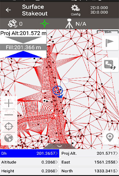
Tersus GNSS has updated its surveying smartphone app, Nuwa. The latest version includes features such as vector map import and digital surface stakeout.
The Nuwa app runs on Android and is reliable, and easy to operate. It has rich and powerful functions that can help surveyors complete measurements more efficiently and accurately.
The app is designed to work with the David and Oscar GNSS receivers from Tersus GNSS, plus other receivers that support NMEA-0183.
New features in Nuwa version 2.3.3.2 include:
Vector map import and stake. The new version supports importing vector maps in DXF, LandXML, KML, and KMZ formats in the import module, optimizes the loading speed of vector maps for display in the Survey and Stakeout interface, and allows direct clicking to select points and lines on vector drawings for staking.
Digital surface stakeout. The new version supports importing DXF files containing 3dface entities and LandXML files containing surfaces, manually selecting points to form Delaunay TIN, and entering surface offsets for fill and cut value interpolation calculations in Surface Stakeout.
Update version description. Now, when receiving a version update, the highlights of the latest version are displayed directly in the application, including essential or market-focused features and fixes for issues.
Existing features of Nuwa include:
Ability to configure base, rover and static surveys
Graphical interface with background map (online/import)
Antenna manufacturer Harxon has launched a new company website, which features eye-catching animations and dynamic illustrations.
“We’ve optimized the website in both the layout and the content,” the company stated in a news release. “You’ll find more detailed product pages, seven major industry applications, and more information about Harxon Corporation.”
New additions include Antenna Customization and Antenna Selection pages, designed to help customers determine which products meet their project needs.
Harxon’s latest products include the survey GNSS antenna HX-CSX633A, the ruggedized HX-CVX606A and the X-Survey OEM antenna HX-CSX179A.
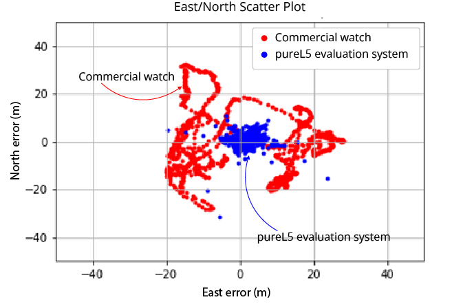
OneNav’s pureL5 more accurate in urban testing without sensor augmentation
Image: OneNav
OneNav is sharing side-by-side test results comparing its pureL5 GNSS receiver customer evaluation system to a leading Android smartwatch.
OneNav is a Silicon Valley, California-based technology company designed to power high-performance positioning for location-dependent mobile services.
In a challenging urban environment, oneNav averaged six times better accuracy than the smartwatch. Both units used commercial-wearable antennas for testing. While the oneNav system used only GNSS measurements, the smartwatch GNSS results were augmented by inertial sensors.
At the 95th percentile, the pureL5 unit reported 8-meter accuracy compared to nearly 29-meter accuracy for the smartwatch; pureL5 accuracy includes artificial intelligence/machine learning algorithms that improve the system over time.
“The L5 signal is more accurate and reliable than L1, it has higher power and wider bandwidth, and it is less jammable,” said Steve Poizner, co-founder and CEO of oneNav. “We looked at where the market is heading, with the wearables and tracking device markets exploding and the demand for higher accuracy increasing, and we asked, ‘Why keep two bands/two RF chains/two antennas when you can get superior performance with just L5?’”
The oneNav team comprises top GNSS experts from Qualcomm, Apple, Intel, SnapTrack, SiRF, Trimble and eRide who have decades of GNSS and mobile industry experience. The team has expertise in GNSS system architecture, multipath mitigation, signal processing, ASIC design and AI/machine learning, and collectively has filed more than 300 career GNSS patents.
Investors include Google Ventures, Norwest Venture Partners and GSR Ventures.
“Seen & Heard” is a monthly feature of GPS World magazine, traveling the world to capture interesting and unusual news stories involving the GNSS/PNT industry.
Ukrainian TV host Serhiy Prytula crowdfunded $20 million to buy Bayraktar drones for the nation’s defense against Russia. Baykar, a Turkish defense manufacturer, turned down the money and opted instead to donate three military drones to the country. The Turkish-made Bayraktar TB2 drone has been a key instrument used by the Ukrainian military to repel Russian forces, with the ongoing war the first major conflict in which the Bayraktar drones have been deployed.
Photo: Nicola Lercari, assistant professor of World Heritage, UC Merced
Arrested Decay
Scientists from the University of California (UC) Merced have mapped the fragile remains of Bodie, a Gold Rush ghost town. With harsh weather conditions, wildfires and earthquakes, only 10% of the original town is still intact. Researchers used a GeoSLAM handheld scanner to document more than 100 structures over four days. The scans preserve Bodie’s archaeological signature and enabled a 3D reconstruction of Bodie at its height in the 1870s.
Sea-level changes are critical to the island nation of Singapore. To help map ground deformation, researchers from the Earth Observatory of Singapore will access GNSS data collected by the Singapore Satellite Positioning Reference Network (SiReNT), along with a decade of archived GNSS data. SiReNT, an initiative of the Singapore Land Authority, produces precise positioning data with up to 3-cm accuracy. With four new coastal GNSS reference stations installed, EOS is beginning to study more accurate ways to measure deformation and climate effects.
A new indoor positioning system is helping hospitals and other healthcare facilities. PenguinIN connects to a facility’s Wi-Fi infrastructure to help staff track and locate key items, a task any nurses say takes an hour of every shift. In emergency rooms, it can track how long patients have waited and how long a physician has spent with each patient. Facilities also can use it to track air quality including dust, temperature and possible water leaks. PenguinIN applies advanced machine learning to establish the location of indoor objects, people and smartphones with up to 1-meter accuracy.
Galileo Second Generation Batch#1B satellites. (Image: ESA).
Technology multinational GMV has been awarded the NAVGUARD project by the European Commission.
NAVGUARD (Advanced Galileo PRS Resilience for EU Defence) will develop ground and space systems to detect illegal activities on GNSS frequencies and geolocate their sources. It also will build an information-management subsystem together with a user interface to provide a situational awareness picture.
The Galileo Public Regulated Service (PRS) is an encrypted navigation service for governmental authorized users and sensitive applications that require high continuity.
According to the EU Agency for the Space Programme (EUSPA), the PRS signal will ensure better continuity of service to authorized users when access to other navigation services may be degraded (resilience). In cases of malicious interference, PRS increases the likelihood of the continuous availability of the signal-in-space (robustness).
NAVGUARD is among various European Defence Fund (EDF) projects designed to sharpen the competitiveness of the European Union defense industry and strengthen the EU’s strategic autonomy. Besides navigation, the projects contracted to GMV will focus on developing missile defense system capabilities, systems for dismounted soldiers, avionics, command and control and cyber defense.
The 2022 Public Interface Control Working Group and Open Public Forum will take place virtually on Sept. 28, the U.S. Air Force has announced. It is hosted by Space Systems Command, Military Communications and Positioning, Navigation, Timing Directorate.
The following NAVSTAR GPS public documents will be discussed:
IS-GPS-200 (Navigation User Interfaces)
IS-GPS-705 (User Segment L5 Interfaces)
IS-GPS-800 (User Segment L1C Interface)
ICD-GPS-870 (Control Segment [OCX] to User Support Interface).
The virtual meeting can be accessed via the following dial-in numbers and links:
Easily installed GNSS guidance kits offer access to design and payload data
Heavy equipment maker Komatsu is offering Smart Construction Retrofit kits to enable affordable fleet upgrades. With the kits installed, conventional Komatsu excavators become “smart” with 3D guidance and payload monitoring.
Once a conventional excavator is retrofitted, operators no longer have to set up a laser or bench every time the machine moves. The kit’s GNSS receiver determines where a machine is on the job site and what the target grade is. The need for additional labor is reduced because the technology collects and delivers information directly to the operator, so fewer people have to be working on the ground or in an open trench.
Designed to improve grading performance and provide more time- and cost-management tools, Smart Construction Retrofit can bring 3D to most Komatsu excavators in a fleet. The entry-level solution can help bridge the technology gap. It gives operators the latest design data, measures payload volumes and load counts, and allows managers to monitor production from the office by integrating Smart Construction applications.
The payload meter helps prevent overloaded trucks by promoting proper loading weights for on- and off-road vehicles, to reduce the potential for equipment damage and other risks.
Trimble has introduced the Trimble X12 scanning system to the geospatial scanning portfolio. The X12 integrates intuitive Trimble software for precise data capture and in-field registration with 3D laser scanning and imaging hardware technology from Zoller+Fröhlich (Z+F), combining the expertise of two industry leaders into a single solution.
The Trimble X12 can be operated by using Trimble Perspective field software installed on a Trimble T10x tablet to enable registration and refinement of scans in the field, ensuring project accuracy and completion before leaving the jobsite. Users can also leverage Trimble’s customized onboard software menu to configure and operate the scanner.
Data is exported from the field and processed in the office with Trimble RealWorks software or third-party software. Final deliverables can be shared online with clients and stakeholders using Trimble Clarity, a browser-based data collaboration and visualization tool.
Transforming high-quality 3D data into decisions — such as using scans, models and imagery to determine the structural integrity of aging infrastructure — is streamlined with the Trimble X12 because the data can reside within the Trimble software ecosystem. This allows users to easily visualize, manage and evaluate the project throughout the entire workflow, even for beginners and new users to scanning technology.
With features including range (from 0.3 up to 365 meters) and scan speed of up to 2.187 million points per second, the Trimble X12 produces scan data and images with high quality and clarity, complementing the Trimble X7’s capabilities within the scanning product portfolio.
“The Trimble X12 puts the most advanced 3D scan and image capture within reach for a variety of skill levels,” said Jacek Pietruczanis, business area director for Scanning and Mobile Mapping, Trimble Geospatial. “The system enables advanced scanning professionals to improve their productivity with top-of-the-line performance and efficiency gains, while those new to scanning can easily unlock this advanced capability with the touch of a button.”
On July 14, the U.S. House passed its version of the National Defense Authorization Act (NDAA) for fiscal year 2023, which begins Oct. 1, 2022.
The report released with the legislation contains several provisions of interest for the GPS and positioning, navigation and timing (PNT) communities. Perhaps most intriguingly, it indicates the National Guard is considering a program to ensure it has one or more sources of time independent from GPS.
Here are some of the more interesting PNT-related mentions in the report.
GPS Disruption & RF-Based Alternatives
A provision entitled “Briefing on Disruption of Global Positioning System” reiterates concerns Congress has expressed repeatedly over the last two decades.
On the civil side, these concerns have resulted in prohibiting the U.S. Coast Guard from disposing of old Loran facilities until a backup for GPS is decided upon and requiring the Department of Transportation to establish a timing alternative to GPS.
Most of Congress’ attention has been focused on the Department of Defense (DOD), though. Over the years, it has tasked the department with a wide variety of briefings and actions including reporting on threats to GPS, how DOD will operate in GPS-denied environments, progress (or lack thereof) in OCX and M-code, and development of alternative PNT systems.
The 2021 NDAA took a more activist approach and required DOD to “generate resilient and survivable alternative positioning, navigation and timing signals.” It also directed the department to work with the National Security Council, the departments of Transportation, Homeland Security, and others “to enable civilian and commercial adoption of technologies and capabilities for resilient and survivable alternative positioning, navigation, and timing capabilities to complement” GPS. The act mandated that this all be completed within two years.
Photo: Andrea Izzotti/Shutterstock.com
The 2023 NDAA reinforces Congress’ long standing concerns about “increasing threats of disruption” to GPS, stating “it is critical to invest in technologies that provide resilient and assured positioning, navigation and timing capabilities…”
Language in that same provision, though, focuses just on alternate navigation capabilities as opposed to full PNT. The act requires a briefing before the end of this year about DOD’s plan across the Future Year Defense Program (FYDP) for “alternative navigation broadcast services.” The briefing is required to include information about “progress on radio frequency-based alternative navigation solutions,” what the department is doing now, and cost estimates for infrastructure and other expenses across the FYDP.
Army MAPS Program
The Army’s Mounted Assured PNT System (MAPS) is focused on ground vehicles. Information on the service’s website seems to indicate the upgrade in the first generation of MAPS is an anti-jam antenna. The overall program of record is more ambitious, according to the site, and includes M-code, other GNSS and inertial sensors.
“Path to ALTNAV” and “Open Standards Interfaces” are also listed as features in the MAPS final version. This is likely incorporation of DOD’s mandate for modular open system architecture to ensure the ability to easily integrate future navigation and timing systems and signals.
The Army is already producing and fielding the Gen 1 version of MAPS. In March 2022, the Aberdeen Proving Ground News announced that 1,000 units had been fielded.
In its report accompanying the NDAA, Congress expressed concern with the pace of the MAPS program. It notes the Army has procured 2,000 units — a small fraction of the 225,000 ground vehicles the service operates.
The text of the congressional report also seems to indicate the program is not much beyond the point described on its website two years ago. The website says a Program of Record technical solution was planned to have been finalized in September 2020.
The House version of the bill would require the Army to provide a briefing on:
technical performance of candidate systems to incorporate into MAPS
the cost of these systems and integration
plans to deploy MAPS to the Army’s fleet of vehicles
plans to upgrade the Gen I MAPS units already fielded.
Another indication of the delayed pace of the program is that this briefing is not due for more than a year, in December 2023.
Autonomy Software for PNT-Denied Environments
While much less specific, another interesting PNT-related provision is a requirement for DOD to “Report on autonomy software for Next Generation Air Dominance.”
It describes a developing Air Force strategy for using piloted and unpiloted aircraft alongside each other. The software “could enable the continued operational capability of systems in positioning, navigation and timing-denied environments.” The Navy and Marine Corps are developing a similar concept.
Photo: Brian Kinney/Shutterstock.com
Little public information is available concerning any of the Next Generation Air Dominance programs or supporting systems. Experts have speculated, though, that operation in PNT-denied environments would likely involve some of the aircraft remaining outside the denied area and providing PNT information to the others via one or more links.
National Guard and Nationwide Alternative Timing
At the end of a section entitled “Collaboration on positioning, navigation, and timing research,” the House report reveals that the National Guard is concerned about relying entirely on GPS for timing and seems to have begun to address that shortfall.
It requires a report no later than February 2023 on the Guard’s “Nationwide Integration of Time Resiliency for Operations (NITRO) effort.” The report should address, among other things, mission need, capability gaps, estimated costs and how the department is collaborating with other federal, state and local entities.
The budget item for NITRO cites malicious cyberattacks that can impact command and control (C2) systems. It says the Guard’s ability to support civil authorities and critical infrastructure is at risk if not mitigated with resilient time.
While attempts to reach the National Guard for comment have been unsuccessful, PNT expert Pat Diamond said the Guard’s concerns and efforts are well justified. “Precision timing is a seriously weak link for everyone in the United States, including critical infrastructure and organizations like the National Guard,” Diamond said. “If GPS timing was not available for some reason, land mobile radios, common operational pictures, the ability to navigate, plus command-and-control systems would suffer greatly, potentially being completely degraded. It’s outstanding that the Guard has realized this and seems to be moving out. All the power to them.”
A Must-Pass Bill
The House version of the 2023 NDAA has yet to be conferenced and reconciled with that of the Senate. While the Senate’s version of the NDAA has been filed, the accompanying report has not yet been released. Since the House provisions seem relatively non-controversial, they are almost certain to be included along with others from the Senate in the final bill and report.
The resulting legislation is almost certain to pass into law.
Congress often struggles to pass even routine legislation. For example, it has only funded the government on time in four of the last 40 years. The annual defense authorization is an exception. NDAA’s are considered “must-pass” bills. Congress has sent one to the president in each of the last 61 years.
Dana A. Goward is President of the Resilient Navigation and Timing Foundation. He is also a member of the President’s National Space-based Positioning, Navigation, and Timing Advisory Board.