Rohde & Schwarz adds an extension to its R&S TS-LBS location-based services test system to meet 112 emergency-call regulations for smartphones
E112 emergency caller location tests are now available on the R&S TS-LBS test system. (Photo: Rohde & Schwarz)
A new regulation requires all smartphones sold in the European Union from March 2022 onwards to support caller location for 112 emergency calls. To ensure this feature, the devices must be compliant with several positioning systems as outlined by the European Commission.
In response, Rohde & Schwarz has added an extension to its R&S TS-LBS location-based services test system. Certification service provider CETECOM has already started E112 testing using these test sequences.
All smartphones sold in the European Union have to be compliant as of March 17 with the Delegated Regulation (EU) 2019/320. A supplement to Radio Equipment Directive (RED) 2014/53/EU, it defines that 112 emergency calls provide caller location information to emergency services in a fast and accurate way, to make sure first responders can arrive at the site of an accident quickly.
Instead of a harmonized standard, a guideline document from the European Commission recommends the testing procedures for Notified Bodies, who support the smartphone vendors in the conformance assessment procedure. Compliance with Galileo, advanced mobile location (AML) and Wi-Fi positioning will be mandatory.
The software-based extension to the R&S TS-LBS location-based services test system makes it a tailored solution in line with the European Commission’s guideline document and the upcoming ETSI standard TS 103 825 for AML protocol testing.
In the Rohde & Schwarz solution, the cellular network is emulated by the R&S CMW500 wideband radio communication tester, while the dual-frequency E1+E5 GNSS Galileo signal is generated by an R&S SMBV100B vector signal generator. Thanks to the automation software of the test setup, all the test cases described in the EC guideline can be executed automatically to ensure unified, fast and repeatable results.
Hamburg-based start-up Beagle Systems has begun building a nationwide network of landing and charging stations for drones.
In Hanstedt (Lüneburger Heide) in the Lower Saxony region of Germany, the first hangar has been set up with an unmanned aerial system (UAS). From there, every surrounding place in Lower Saxony can be reached in a short time.
The drone will be deployed from the Beagle Systems headquarters in Hamburg. Beagle Systems has the corresponding permits for flights beyond visual line of sight (BVLOS).
“The start in Hanstedt is an important step for us,” said Oliver Lichtenstein, one of the three founders of Beagle Systems. “From here we can reach an area of 780,000 hectares in Lower Saxony. As the first provider of drone flights, we are thus on call within a short time at the customer’s site.”
The drone flight can be controlled entirely from Hamburg; on-site personnel deployment is not necessary. This eliminates personnel costs as well as time spent traveling to and from the site. Because of this, Beagle Systems can carry out drone flights at a much lower cost than other providers.
“Our goal is to build a nationwide network of charging stations within the next few years,” said Mitja Wittersheim, COO of Beagle Systems. “An EU-wide expansion is then the next step.” The expansion of the network would allow drone specialists to access a ready-to-go drone from Hamburg for customers at any location within the European Union.
Beagle Systems is a drone-as-a-service provider specializing in long-range flights with unmanned aerial systems. The drones are already in use for the inspection and monitoring of large infrastructure facilities such as power grids.
The company also plans to tap into the multi-billion dollar market of delivery, courier and express services. The Beagle M drone used in Hanstedt was developed in-house. It has a wingspan of 2.50 meters and can transport a load of up to three kilograms.
Dubai-based Intelligent Quantum Labs (Intqlabs) has announced that its latest proprietary technology of enabling location data solely from the Earth’s geomagnetic strength is now patent pending (UAE patent office application 202111049994).
Leveraging more than two decades of experience in developing antennas, sensors, radio analysis platforms and computing algorithms, the new technology incorporates advanced processes to calculate power profile data from magnetic readings. The power profile enables calculation of a location under water, in the air or on the ground within a few seconds.
The technology, dubbed New Global Navigation Satellite System (NGNSS), was developed to serve as an alternative to existing GNSS platforms such as GPS, GLONASS, Galileo, Beidou, QZSS and IRNSS. NGNSS does not depend on satellite constellation and is not susceptible to being jammed, injected, replayed or spoofed.
NGNSS operates on the core principle that every point on Earth’s surface and in its atmosphere has a uniquely calculable magnetic strength reading, or a geomagnetic force. This force changes based on distance from the poles, elevation, altitude, time of day, direction of sunlight, magnetosphere, earthquakes, inner core rotation, crust, declination, inclination, ionosphere, magnetosphere, and gyrations that occur in continuity such as solar storms, elevation, topography, altitude changes, spherical variations and regional anomalies
NGNSS removes interference and noise from geomagnetic readings by using a specialized array of aligned multiple input multiple output (MIMO) antennas connected to a complex network of embedded processors, extremely sensitive fluxgate sensors and other sensors. The antenna and embedded setup processes the magnetic strength reading to obtain the power profile, split the various signals in a profile, and then calculate the direction, origin and location of these sources. This enables NGNSS to identify the true strength of the Earth’s geomagnetic field by removing all sources of interference.
NGNSS is a secure platform unaffected by jamming, replay or injection as it monitors power profiles and simply drops the malicious data. Furthermore, NGNSS is independent of the GNSS constellations, making it a standalone, secure and “always available” platform that can be integrated within any electronic terminal by strategically embedding a chip and antenna.
Nearmap Ltd. has appointed Penny Diamantakiou as chief financial officer (CFO) effective Jan. 31. The announcement follows the promotion of Andy Watt to chief growth and operations officer.
Diamantakiou has had a distinguished career spanning more than 20 years as a business executive with a passion for digital, media and technology businesses. Previously the CFO of 5B, a clean technology leader that accelerates access to low- cost, safely deployed, solar energy, Diamantakiou has also held leadership roles at companies including Optus, Yahoo7, WooliesX (part of the Woolworths Group) and the Association for Data-Driven Marketing & Advertising (ADMA).
Diamantakiou is a graduate of the Australian Institute of Company Directors, holds a master’s degree in business administration (an MBA), a graduate diploma in management, and a bachelor’s in economics. She is also a Fellow Certified Practicing Accountant (FCPA).
“It gives me great pleasure to welcome Penny to the team at Nearmap,” said CEO Rob Newman. “Penny will start from a strong foundation of fiscal management, reporting and transparency established by Andy, and will take our systems forward as we increasingly manage more products, customers and geographies.”
“Just as importantly, Penny shares our core values, and given her passion, commitment and extensive leadership experience working at high growth digital and technology-led businesses, is the right cultural fit to help drive our business and strategy forward,” Newman said. “I look forward to working together as we continue growing our business and expanding our market leadership position.”
View from a weather balloon at 100,000 feet. (Photo: NOAA)
“We’re at 103,000 feet. As you look up the sky looks beautiful but hostile. …Can see for over 400 miles. The sky [above me] is absolutely black. …I can see the beautiful …deep, dark, indescribable blue [sky below], which no artist can ever duplicate. It’s fantastic.”
— Capt. Joseph W Kittinger, USAF, Operation Excelsior III, August 16, 1960
This month, our journey begins in the future. Imagine you are in Alamogordo, New Mexico, a town with a rich history in America’s space program. You are here for a proof-of-concept, real-world exercise. After two years spent training, you are on a team that will test the viability of a stratospheric airframe, or high-altitude platform station (HAPS).
The exercise is a joint venture between several large corporations and U.S. government agencies. The HAPS began as a telecommunications support platform, but now includes many different industries. It will test backup systems for GPS and other sensing technologies.
Remote sensing is an obvious use case, and sensors are onboard to collect hyperspectral and thermal images, synthetic aperture radar, lidar, magnetometry, weather and other types of data. Some equipment is mounted on top of the platform to point toward space to monitor satellites and orbital debris. Also aboard are are satellite relays and space-based communications systems. Additionally, a Hubble-like observatory will support NASA research.
On the ground at the command center, other teams are working on the project. A mapping and survey team is in the field to ground truth the precision, accuracy and resolution of the HAPS data.
Autonomous vehicle manufacturers are testing telemetry data from the HAPS for improved precision navigation. Teams of imagery analysts and geospatial analysts are assessing the quality and value of the products, including full-motion video live-streamed from the HAPS.
Aerospace engineers are studying the performance of the airframe and monitoring its structural integrity. Meteorologists are providing upper air wind and weather forecasts. Several teams of engineers are managing various robotics systems onboard, and more scientists and engineers from multiple companies and agencies are testing their equipment.
The solar-powered Helios in flight. (Photo: NASA/Aerovironment)
Your Mission as a Stratonaut
Most tests and modifications are being handled remotely, but some require replacing the systems. This can only be accomplished by physically going to the sub-orbital station. Imagine this is your job.
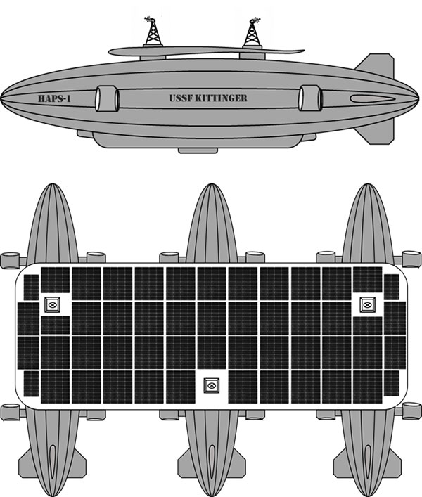
You are a remote sensing technician specially designated as a stratonaut. Your training familiarized you with the various systems onboard. You trained how to use your pressure suit — its dangers, risks and capabilities — and how to interface with the suit’s augmented reality system. You know how the HAPS operates, its schematics, and the interiors of the three connected dirigibles. You can navigate your way around the HAPS and access the various decks and compartments as well as the sensors, equipment, charging ports, fuel cells and motors. You can fly the drones, dock with the station, and enter its hangar bays. You can do maintenance on the autonomous robots and the remote-controlled robots onboard the station. You know the security and safety protocols. All this you know and more; and, if things go wrong, you know what to do.
Vision of the Alpha, Bravo and Charlie HAPS stations. (Image: William Tewelow)
On this mission day, it’s early morning. Sunlight is beginning to pierce the sky above the Alamogordo base station. Two technicians are helping you into your pressure suit. Another technician at a desk has your helmet hooked up to the computer. The LED lights encircling the facemask blink slowly, indicating data is being uploaded. The augmented reality face shield glows a soft blue as the data flashes across it.
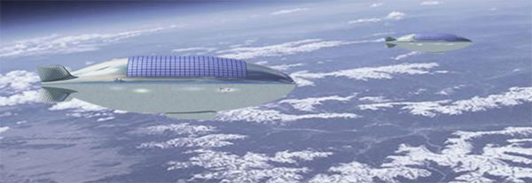
Overnight at the command center, operators controlled descent of the HAPS from 100,000 feet. It takes 10 hours to reach 65,000 feet, the altitude for your rendezvous with the station. You will fly up to the HAPS in a cargo delivery drone and dock at the forward hangar bay of Station Bravo (the second dirigible). You’ll be installing an enhanced high-resolution hyperspectral sensor array in the station’s lower observation deck.
While you are busy with the installation, the autonomous robot onboard will be in the hangar bay, swapping out the station’s spent fuel cells with fresh ones carried up by the cargo drone. Each weighs 250-pounds. After this task, the cargo drone will fly to Stations Alpha and Charlie and swap out their spent fuel cells.
Once all three are completed, the cargo drone will return to Station Bravo and take you to the top of Station Charlie to install a satellite laser relay (SLR) communications system. A remote-controlled robot operated by the engineering team at base command will meet you and carry the SLR up to the tower. While you are installing the SLR, the cargo drone will dock and recharge for your return trip. The entire mission will take seven-hours and 45 minutes.
“Many functions currently done with satellites could be performed for tactical and operational commanders using near-space assets, much more cheaply and with much greater operational utility. By operationally grouping near-space with space, the functional expertise synergies would allow much more efficient delivery of space effects to the joint commander.”
— Lt. Col. Edward B. Tomme, Ph.D., USAF, Air Power Research Institute
Two Types of Pseudolites
High-altitude, long-endurance (HALE) airframes — also referred to as pseudo-satellites, pseudolites and stratolites — are of two types.
Heavier than air. The heavier-than-air (HTA) type is a lightweight, fixed-wing aircraft with extremely long wingspans. It can stay aloft for a month or more.
HTAs are limited to carrying small payloads. They typically rise to 100,000 feet during the day powered by their solar cells, and at night descend to 60,000 feet, repeating this cycle until the batteries need replacing. The HTA platform is good for short-term missions over a broad area of interest because it normally flies in large circular patterns.
Lighter than air. The other type of pseudo-satellite is a lighter-than-air (LTA) airframe. The typical example is a dirigible, but these platforms can take on many shapes and sizes. LTAs can be enormous, with lifting capacities upward of 100,000 pounds. They operate as geostationary platforms loitering indefinitely over an area of interest and remain at the same altitude day and night. An LTA can last for 10 years or more.
The best solution is a combination of the two. A large LTA can serve as a base station to support several small HTA platforms.
“Together, NASA and the Space Force seek to advance, protect and sustain activities in, from and to space. This is truly a new era of strategic collaboration that will benefit commercial, civil and national security in space.”
— John W. Raymond, General, Chief of Space Operations, United States Space Force
A stratosphere-based telecommunications platform proposed by the Elefante Group. (Image: FCC)
HAPS Alliance
Furthering the development of the pseudo-satellite industry is a consortium of 49 companies and universities called the HAPS Alliance, which advocates for investment in this area.
The stratosphere has become increasingly important for commercial interests and national security. HAPS can provide the best of what manned aircraft operating at lower altitudes can offer, combined with the benefits of satellites, minus much of the downside of each.
Limits of aircraft. Aircraft operating at lower altitudes offer high resolutions and targeted collection. They can be easily retasked and rerouted, and equipment can be easily repaired or replaced. Aircraft are limited by constraints of time, fuel, weight, distance and weather.
Limits of satellites. Satellites, on the other hand, provide broad area coverage and long-term, operational endurance, but they are 240 miles or more above the Earth traveling at 17,500 miles per hour, or they are 18,000 miles above the Earth to maintain a geostationary orbit. It is a trade-off between resolution and dwell time.
Other drawbacks of satellites are their expense. Launching is costly and recovery is nearly impossible to make repairs. Doing so is impractical.
HAPS do not have those limitations. They can provide long-term, persistent operations over an area of interest at very high resolutions. They also can carry a complete package of sensors and equipment with the additional benefit that most everything can be repaired or replaced with minimal cost.
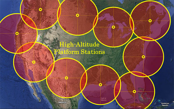
Locations of HAPS to cover the borders of the Continental United States. (Image: William Tewelow)
How HAPS Will Improve Geospatial Data
These systems are going to improve geospatial information. HAPS will improve spectral resolutions by a factor of 10x or better. The improved location accuracy data will impact navigation, surveying, construction, emergency services, logistics, transportation, aviation, agriculture and most other industries.
The HAPS will act in tandem with cellular networks on the ground to improve internet connectivity and telecommunications. They will improve national security while monitoring the effects of climate change, deforestation, urban sprawl, ozone, pollution and natural disasters such as floods, forest fires, tornadoes, hurricanes and more.
Provided testing proves HAPS a success, the pseudosatellite era is going to greatly impact most everyone’s life. If you are lucky, you might actually become a stratonaut. If you are interested, now is the time to prepare.
“This point of observation commands an area nearly 50 miles in diameter. The city, with its girdle of encampments, presents a superb scene. I have pleasure in sending you this first dispatch ever telegraphed from an aerial station.”
— Thaddeus S. C. Lowe, First Chief Aeronaut, Union Army Balloon Corps, Civil War, 1861
William Tewelow
William Tewelow is a Senior Aeronautical Information Specialist for the Federal Aviation Administration. He is a designated Geographic Information Systems Professionals (GISP). He served on special assignment to the U.S. Department of Transportation and led a national strategic geospatial initiative under the authority of the White House Open Data Partnership. He was among the first in the nation to earn a Geospatial Specialist Certification from the U.S. Department of Labor while working at NASA Stennis Space Center.
He is a 2016 graduate of the FAA’s management fellowship Program for Emerging Leaders. He has degrees in Geographic Information Technology and Intelligence Studies and is earning a master’s degree in Organizational Leadership with a focus on Performance Management. He is a mentor with the FAA’s National Mentor Program.
Tewelow retired from the U.S. Navy after serving 23 years as a Geospatial and Imagery Intelligence Specialist, a Naval Aviator, a Meteorologist, and a Tactical Oceanographer earning three achievement medals. He is married, enjoys traveling, connecting people, solving problems, and interested in new technology. His favorite quote is, “A man’s mind changed by a new idea can never go back to its original dimension.” ~ Oliver Wendell Holmes
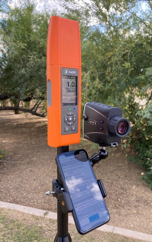
Bad Elf LLC now provides an integrated laser-offset workflow for acquiring high-accuracy field data in GNSS-challenged environments using Esri ArcGIS Field Maps for Android.
The workflow integrates Bad Elf and Laser Tech (LTI) hardware in collaboration with ArcGIS technology from Esri.
“Extending compatibility to the Android mobile operating systems further promotes our commitment to the bring-your-own-device (BYOD) professional,” said Larry Fox, vice president of marketing and business development at Bad Elf. “As a member of the Esri Partner Network, we are pleased to collaborate with Esri in offering this capability to our Android customers.”
The Bad Elf Flex connects to any LTI TruPulse rangefinder over a wired or Bluetooth connection to deliver high-accuracy location data to Esri ArcGIS Field Maps. Mobile workers can efficiently complete position and height data collection in access-limited situations, saving time, money and effort.
“With the inclusion of Android support, Bad Elf introduces a powerful and innovative solution for accurate location offset and height data capture that extends the capabilities of ArcGIS Field Maps across all supported platforms,” Esri Product Lead Jeff Shaner said.
Bad Elf’s app workflow focuses on enhancing productivity, reducing field collection difficulties, and mitigating quality issues. The Bad Elf app workflow runs on Android and iOS. Connection versatility minimizes operating system limitations and allows for app-based or standalone operation.
Bad Elf also provides free tools for Esri ArcGIS Desktop and ArcGIS Pro for configuring offset-enabled point-feature capture using the ArcGIS Field Maps on iOS and Android.
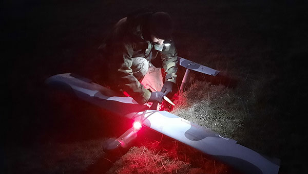
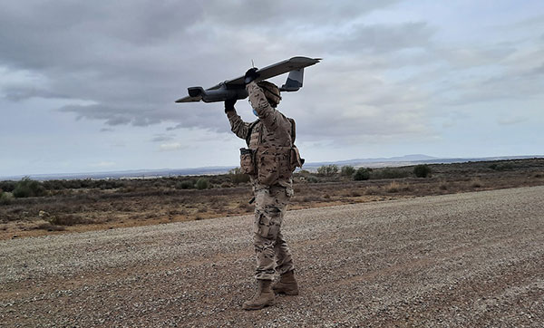
The Seeker UAS proved itself a vital asset in a recent exercise for the Spanish Navy. The UAS, developed by GMV and Spanish technology company Aurea Avionics, was used for intelligence gathering through threat identification, tracking vehicles and other targets, and assessing terrain, routes and settlements.
The Marine Infantry Brigade (BRIMAR), part of the Tercio de Armada de Infantería de Marina (Marine Infantry Protection Force), deployed the Seeker Dec. 9-13 at the San Gregorio national training center in Zaragoza during an exercise known as FTX-BRIMAR 21.
In the demanding live-fire exercises, the BRIMAR troops were able to take full advantage of the Seeker’s autonomy and range to conduct operations from advantageous locations — even in adverse weather conditions, with surface winds exceeding 40 knots — and to arrange autonomous takeoffs and landings in conditions providing little to zero visibility, including night flights.
Photo: GMV
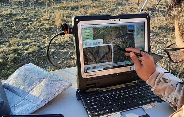
Despite the complex environment, the Seeker UAS was able to deploy smoothly and enabled the BRIMAR to locate targets both day and night thanks to its dual payload, complete with both a thermal and visible light camera. This contributed to the success of the exercises.
During the exercises, the Seeker UAS processed available data sources to supplement the video with information of use to all deployed troops, not just the system operators: the video and data generated was distributed in real time to the BRIMAR control station using VidStream, a secure, high-quality, latency-free video and data transmission system. This was done using the new RF-7800H-MP radios from L3Harris, which are natively integrated into VidStream. With this setup, the Seeker UAS was the only system to relay video from its ground position to the control station.
Photo: GMV
The Seeker system was involved in the exercises under the RAPAZ program led by the Subdirectorate-General for Planning, Technology and Innovation, which reports to Spain’s Directorate General of Weapons and Material.
The Seeker UAS is in the Class I Mini segment for defense. It has endurance of 90 minutes, a range of 15 km and a weight of 3.5 kg. Both the Spanish Navy and the Spanish Army received the first Seeker UAS units to reinforce the intelligence, surveillance and reconnaissance capabilities of the elite Marine Infantry Protection Force and the Spanish Army’s elite Almogávares VI Paratrooper Brigade.
TerraStar-C PRO is the first global correction service from Hexagon to incorporate RTK From the Sky technology to achieve RTK-level accuracy in three minutes with 99.999% availability
In late 2020, Hexagon’s Autonomy & Positioning division announced its technological breakthrough of global RTK From the Sky, demonstrating a future where instantaneous PPP and global RTK-level accuracy is possible.
Integrating this innovation into the core of TerraStar-C PRO, NovAtel’s corrections service, is the first phase in implementing RTK From the Sky technology into the company’s diverse portfolio of correction services for users worldwide.
As a result, TerraStar-C PRO has become the fastest global correction service to provide centimeter-level accuracy, not just in open-sky environments but also across challenging conditions created by buildings and foliage, according to Hexagon | NovAtel.
“RTK From the Sky technology is the foundation that enables our global correction services to be world-leading across agriculture, automotive, defense, survey, marine and autonomous applications,” said Michael Ritter, Autonomy & Positioning division president and CEO. “Our dedication to research culminated in an industry-changing technology; we’ll continue that commitment by providing the best positioning experience in speed, accuracy, availability and reliability anywhere in the world.”
TerraStar-C PRO now converges in less than three minutes by utilizing quad-band receiver and antenna technology to leverage modernized BeiDou III, GPS III and Galileo E6 signals. The resulting process generates state-of-the-art corrections for all GNSS frequencies.
Hexagon is a consistent innovator in GNSS, as seen in its role in developing RTK and PPP solutions. With this next-generation modernization of PPP correction generation and algorithm development, the company continues this tradition in providing the highest quality and best performing global positioning experience to users with land- and air-based applications.
“It’s been a privilege to collaborate across the division to develop RTK From the Sky technology and leverage our collective expertise in correction generation, PPP algorithms and the entire positioning ecosystem,” said Leos Mervart, head of PPP algorithm development at Hexagon’s Autonomy & Positioning division. “I’ve worked with PPP technologies since the beginning of my career and am proud to say that this is a new era of what global positioning can look like.”
The TerraStar-C PRO improvements are accessible now through the 7.08.10 firmware release for users on OEM7700, OEM719 and OEM729 cards and their associated enclosures for land and air applications.
Future firmware releases will include global RTK From the Sky technology throughout Hexagon’s correction service portfolios for its global client base, including precision agriculture and marine applications.
To learn more about TerraStar correction services or to request a free 5-day trial, visit NovAtel.com/TerraStar.
New radiation-tested, tactical-grade MEMS inertial accelerometers designed for spacecraft electronics testing
Silicon Designs Inc. has launched the Model 1527 series, a family of miniature, radiation-tested, tactical-grade micro-electromechanical (MEMS) inertial accelerometers.
Offered in three full-scale acceleration ranges — ±10 g, ±25 g and ±50 g — the series is designed to support a variety of critical space electronics testing requirements, including those of spacecraft, satellites and CubeSats.
In addition, their small bias and scale-factor temperature coefficients, excellent in-run bias stability, and zero cross-coupling make the Model 1527 series particularly well-suited for spacecraft electronics testing applications requiring low power consumption (+5 VDC, 6.5 mA), low noise, long-term measurement stability in –55° C to +125° C environments, and performance reliability under intermittent radiation exposures.
Radiation test report data, as generated during internal qualification testing, is available on request.
The rugged design of the Model 1527 series combines a tactical-grade MEMS inertial sense element with a custom integrated circuit, internal temperature sensor, onboard sense amplifier and ±4V differential analog output stage. The MEMS inertial sense element and internal components are housed within a lightweight, hermetically sealed, nitrogen-damped, miniature, RoHS compliant, J-lead LCC-20 surface mount ceramic package (U.S. Export Classification ECCN 7A994), weighing 0.68 grams.
Its compact and lightweight footprint allows for ease of accelerometer installation within space-constrained environments, as well as minimization of mass loading effects. Each Model 1527 Series accelerometer is marked with a serial number for traceability on both top and bottom surfaces.
All Silicon Designs’ Model 1527 Series tactical-grade MEMS inertial accelerometers are designed, manufactured, performance-verified and calibrated in-house at the company’s global corporate headquarters and R&D center outside of Seattle, Washington. Product performance documentation is supplied at the time of shipment, including residuals, thermal sensor model, acceleration model, bias, scale factor, linearity, operating current and frequency response data.
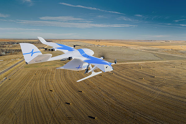
German drone-delivery company Wingcopter has signed a commercial agreement with Spright worth US$16 million to enable UAV medical deliveries.
Spright is a subsidiary of American air medical service provider Air Methods. Under the agreement, Spright is acquiring a fleet of Wingcopter’s flagship delivery drone, the Wingcopter 198, to meet the increasing demand for medical drone deliveries throughout the United States.
The contract makes Wingcopter the exclusive provider of fixed-wing electric vertical take-off and landing (eVTOL) delivery-drone technology to Spright. Spright, in turn, becomes exclusive provider of maintenance, repair and overhaul for the Wingcopter 198 to third parties in the United States.
Drone Division Launched
Spright was launched in July 2020 as the new drone division of Air Methods to improve healthcare access and minimize supply challenges for customers across the United States. To this end, Spright is creating a drone-based, U.S. healthcare-specific delivery network leveraging an existing infrastructure of more than 300 bases, serving hundreds of hospitals across 48 states in predominantly rural areas.
The agreement further strengthens the strategic partnership between the two companies, announced in August 2021. Spright is closely supporting Wingcopter in its Federal Aviation Administration (FAA) UAS type-certification process, leveraging Spright’s aviation experience operating FAA 121 and 135 air carriers, its existing Part 135 certificate (on-demand air service) and safety management system program.
Spright is collaborating with Hutchinson Regional Health System in Hutchinson, Kansas, for initial tests, and plans to expand the service beyond Kansas with additional strategic medical projects later this year.
The Wingcopter fleet will increase healthcare access across rural and underserved communities by enabling instant and on-demand delivery of vital medical supplies, medications, vaccines, blood and lab samples between medical facilities. It will also improve quality of care for patients with faster turn-around time of lab samples and more targeted treatments for patients.
Finally, the electrically powered Wingcopter cargo drones will reduce the medical industry’s carbon footprint, contributing to greener and more sustainable supply chains with faster and more predictable delivery times.
Wingcopter and Spright will showcase the Wingcopter 198 delivery drone and provide an opportunity to meet executives of both companies at the logistics tech conference Manifest in Las Vegas Jan. 25-27.
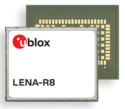
U‑blox has added a GNSS receiver module to its cellular LTE Cat 1 portfolio. The GNSS receiver in the LENA-R8 is based on the u‑blox M10 platform.
U-blox also introduced the LARA-R6, its smallest LTE Cat 1 module with global coverage. Together, the modules comprise five certified global, multi-regional and regional product variants, simplifying logistics for product developers and increasing design flexibility.
Both modules offer device makers facing imminent 2G and 3G network sunsets a future-proof migration path to 4G technology for data-streaming applications.
Additionally, they offer MQTT Anywhere and MQTT Flex connectivity via u‑blox’s Thingstream platform out of the box, thereby enabling low-power, low-cost connectivity with globally ubiquitous, seamless roaming.
Tracking and Telematics
The LENA-R8 standard-grade module series targets customers in the tracking and telematics markets seeking to minimize costs associated to their bill of material and data charges. The compact module balances cost and performance with single Rx antenna and primarily targets customer deployments in the Europe, Middle East, Africa, Asia, and South America regions.
The LENA-R8 supports a broad range of frequency bands with 2G fallback, providing maximum roaming coverage for global tracking applications using a single stock keeping unit (SKU).
A variant of the LENA-R8 series comes with an ultra-low power u‑blox M10 GNSS receiver for high performance asset tracking applications, reducing integration effort and time to market. Making no compromises in terms of GNSS performance, the module can concurrently receive up to four GNSS constellations for maximum position availability.
CellLocate Support
All variants of the LARA-R6 and LENA-R8 family support CellLocate, u‑blox’s cellular network-based location service, for coarse positioning data even in the absence of GNSS signals.
Engineering samples will be available in February.
Space Systems Command, together with United Launch Alliance and other mission partners, successfully placed the fifth and sixth Northrop Grumman-built Geosynchronous Space Situational Awareness Program (GSSAP)-5/-6 satellites into orbit for the U.S. Space Force, after an on-time launch aboard an Atlas V rocket from Space Launch Complex (SLC)-41 at Cape Canaveral Space Force Station, Florida, at 2 p.m. EST (11 a.m. PST).
“The evolving threat to our space environment requires new levels of resiliency and survivability, autonomy and automation, and unprecedented levels of integration and networking,” said Lt. Gen. Michael A. Guetlein, commander of Space Systems Command. “Today’s successful launch will enhance our capabilities in space domain awareness and our space-based space domain awareness architecture. Congratulations to the USSF-8 integrated team and all mission partners on a successful launch.”
The GSSAP-5/-6 satellites join a constellation supporting U.S. Space Command’s space surveillance operations as a dedicated Space Surveillance Network sensor.
GSSAP also supports the Combined Force Space Component Command by collecting space domain awareness data, allowing for more accurate tracking and characterization of manmade orbiting objects. GSSAP is led by SSC’s Special Programs directorate.
The National Security Space Launch (NSSL) mission launched aboard ULA’s Atlas V in the “511” configuration, which was comprised of a five-meter diameter payload fairing from RUAG Space, a single Graphite Epoxy Motor (GEM)-63 solid rocket booster from Northrop Grumman, and a single RL-10 engine from Aerojet Rocketdyne on the Centaur upper stage.
SSC’s Launch Enterprise acquired the launch service through ULA and was responsible for successfully placing the GSSAP satellites on orbit.
The NSSL program provides assured access for the United States’s critical warfighting space assets, and this launch vehicle has reliably placed valuable assets into their intended orbits repeatedly, adding to the NSSL program’s success record of 88 consecutive launches. The program supports a full range of government mission requirements for the nation’s defense and intelligence sectors.
Space Systems Command is the U.S. Space Force field command responsible for rapidly identifying, prototyping and fielding resilient space capabilities for joint warfighters. SSC delivers sustainable joint space warfighting capabilities to defend the nation and its allies while disrupting adversaries in the contested space domain. SSC mission areas include launch acquisition and operations; space domain awareness; positioning, navigation and timing; missile warning; satellite communication; and cross-mission ground, command and control and data.
A ULA Atlas V rocket carried the USSF-8 mission for the U.S. Space Force into orbit, (Photo: ULA)