Author: Tracy Cozzens

  • NBT’s Prometheus employs Nordic’s nRF9160 SiP for IoT and GNSS

    NBT’s Prometheus employs Nordic’s nRF9160 SiP for IoT and GNSS

    Photo: Next Big Thing
    Photo: Next Big Thing

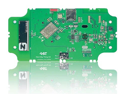
    German venture studio Next Big Thing AG (NBT) has launched the Prometheus internet of things (IoT) sensor-based development platform designed to simplify prototyping and speed time-to-market for developers of cellular IoT- and cloud-based solutions.

    The Prometheus platform is powered by Nordic Semiconductor’s nRF9160 low-power system-in-package (SiP) with integrated LTE-M/NB-IoT modem and GNSS. The platform supports development across a wide range of industrial applications including the manufacturing, pharmaceutical and logistics sectors.

    The nRF9160 SiP’s 64-MHz Arm Cortex-M33 dedicated application processor provides sufficient computational power to not only supervise the LTE-M/NB-IoT modem’s cellular connectivity, but also all other product functionality. The SiP’s 1MB Flash and 256kB RAM supports fast response and complex application software.

    In addition to the Nordic SiP, the CE-certified development platform features a wide range of sensors and interfaces, a stable embedded software stack, fully encrypted communication, mesh connectivity for short-range communication, automatic switching between NB-IoT and LTE-M cellular IoT connectivity, and advanced provisioning tools. The solution is optimized for low power consumption and provides an industrial temperature range of –40 to +85° C.

    NBT’s IoT development platform comprises two main components:

    • the hardware and embedded software platform (Prometheus)
    • the cloud-based software platform (NBT software platform).

    The standard configuration of Prometheus consists of a range of sensors, for example a temperature sensor (analog and digital), accelerometer, magnetometer, gyroscope, air quality sensor, ambient light sensor and humidity sensor.

    The extended version of Prometheus also includes Nordic’s nRF52832 Bluetooth 5.2/Bluetooth Low Energy (Bluetooth LE) general purpose multiprotocol system-on-chip (SoC) to provide support for Bluetooth LE connectivity, as well as USB, GPS, radar, an adjustable antenna tuner and extended temperature range.

  • US Army selects Orolia Defense & Security as winner in XTech Plugfest

    US Army selects Orolia Defense & Security as winner in XTech Plugfest

    Company prevails in military’s pursuit of CMOSS PNT solutions

    Recognized for its outstanding technology achievements and the potential for impact to the United States Army and Department of Defense (DOD), Orolia Defense & Security was selected by a panel of judges as a finalist during the 2021 xTech Plugfest competition.

    Hosted by PEO IEW&S, PM-PNT, the event allowed industry participants to demonstrate C5ISR/EW Modular Open Suite of Standards (CMOSS) capabilities via PNT cards, switch cards and chassis.

    The event took place at the Open Innovation Laboratory (OIL) on Aberdeen Proving Grounds, Maryland, Nov. 8-19, 2021.

    Photo: Orolia
    Photo: Orolia

    CMOSS prescribes criteria for integrators that reduce the size, weight, and power (SWaP) of C5ISR and EW systems while increasing their flexibility and adaptability by enabling the sharing of hardware and software components.

    Orolia submitted a CMOSS timing card and was formally recognized as a top five winner at OIL’s open house (with 200+ attendees) for demonstrating its capabilities and commitment to supporting the U.S. Army and DOD in pursuit of CMOSS PNT solutions.

    “I am extremely proud of our team for their efforts and sharp-wittedness in developing and presenting this technology at an accelerated level,” said Conrad Meyer, director of business development at Orolia Defense & Security. “We are honored to have taken part in this event and to be distinguished among many contenders.”

    Orolia’s prototype has a plug-and-play architecture powered by its FlexFusion engine, with additional capability for jamming and spoofing detection via its patented BroadShield software. It is designed for easy in-field upgradability.

    Orolia plans this year to release a commercially available, fully compliant CMOSS/SOSA PNT card for use in military air and ground-mounted systems.

  • Raytheon swarm enables one operator to guide 100+ drones

    Raytheon swarm enables one operator to guide 100+ drones

    Raytheon BBN-led team recently supported DARPA's fifth OFFSET program field exercise. (Photo: Raytheon)
    Raytheon BBN-led team recently supported DARPA’s fifth OFFSET program field exercise. (Photo: Raytheon)

    Raytheon Intelligence & Space, a Raytheon Technologies business, recently supported the fifth OFFensive Swarm-Enabled Tactics (OFFSET) DARPA program field exercise.

    Using integrated swarm technology developed by a Raytheon BBN-led team, a single operator successfully controlled a swarm — composed of 130 physical drone platforms and 30 simulated drone platforms — both indoors and outdoors in an urban setting. Raytheon BBN provides advanced technology research and development with a focus on national security priorities.

    During the exercise, the team used a combination of commercial off-the-shelf and custom-built hardware and software to deliver swarm autonomy. This enabled a single or small group of operators to direct and manage the activities of a large swarm of autonomous air and ground vehicles with minimal training.

    “Controlling a drone swarm changes the way an operator or group of operators think about the drones,” said Shane Clark, Raytheon BBN OFFSET principal investigator. “Takeaways from this exercise help inform us of the inflection points between utility and manageability.”

    Inexpensive Hardware

    A key element of the program is the use of inexpensive hardware. Without the powerful computing and sensing capabilities available in larger more expensive platforms, Raytheon BBN needed to create a broad library of simple tactic building blocks used to create plans to accomplish mission objectives.

    Raytheon BBN also designed and configured a scalable, modular and decentralized approach to manage a variety of current and future platforms and missions. Whenever possible, the drones collaborate actively to decide how to accomplish a specific mission most efficiently.

    “Our software is smart enough to assign drones with the right capabilities to the appropriate set of tasks,” Clark said. “For example, if the task is to surveil a building, multiple drones will be dispatched, with each surveilling portions of the building. The software considers each platform’s sensor capabilities, and tasks drones with downward-facing cameras to surveil the roof.”

    Once the drones are deployed, their collaboration allows them to understand what parts of a building have been explored and where the gaps are. They then autonomously select how to fill in those gaps.

    Virtual Reality Interface

    To tackle the complexities of human swarm interfaces, the Raytheon BBN team created a virtual reality interface in addition to traditional camera views. It takes feeds from all the swarm assets to create an interactive virtual view of the environment.

    “You can look behind the building to access a view of drone locations, for example, and use the virtual reality environment to test and see if your mission is viable,” Clark said. “We also developed a speech interface with the operationally deployed Tactical Assault Kit, or TAK, integration capability that enables the operator to act quickly while maintaining situational awareness over many systems simultaneously.”

    The Raytheon BBN-led team includes Smart Information Flow Technologies, or SIFT, and Oregon State University. The team is contracted by DARPA to demonstrate its swarm capabilities during Army Expeditionary Warrior Experiment 2022 taking place in February to March, and hosted by the Army Maneuver Battle Lab.

  • Seoul Robotics fuels autonomy with Level 5 control tower

    Seoul Robotics fuels autonomy with Level 5 control tower

    Image: Seoul Robotics
    Image: Seoul Robotics

    Seoul Robotics has introduced the Level 5 Control Tower (LV5 CTRL TWR), a mesh network of sensors and computers on infrastructure that guides vehicles autonomously without requiring that sensors be placed on individual vehicles.

    The technology is in the early stage of commercial deployment to automate last-mile fleet logistics at BMW’s manufacturing facility in Munich. The system has the potential to transform operations for a wide range of business applications, from vehicle distribution centers to car rental companies and trucking logistics.

    Seoul Robotics is a 3D perception solution company using deep learning artificial intelligence (AI) to power the future of mobility,

    By placing sensors equipped with 3D perception software around vehicles — traffic lights, buildings and highway overhangs — the system can fully capture the environment and communicate with other sensors and the 4/5G systems that come standard on vehicles.

    The LV5 CTRL TWR collects all the 3D data, and then automates vehicles accordingly using V2X communications.

    “Level 5 mobility has been proven to be more challenging to achieve than expected, until now,” said HanBin Lee, CEO of Seoul Robotics. “LV5 CTRL TWR has massive potential to fuel autonomous mobility, and we are thrilled to continue expanding upon the implementation of this technology with BMW and other partners.”

    “Ultimately, these systems will be deployed in additional public and commercial settings, powering aspects of our everyday lives, such as autonomously navigated parking and public transit,” Lee said. “With LV5 CTRL TWR, this future is closer and more accessible than ever.”

    The collaboration with BMW leverages hundreds of connected lidar and 3D sensors on infrastructure to automate newly manufactured vehicles within factories and vehicle distribution centers without any human involvement. By making this process autonomous, automakers like BMW can increase operational efficiencies and safety within automotive logistics.

  • US Army selects TRX Systems to provide DAPS PNT system

    US Army selects TRX Systems to provide DAPS PNT system

    The TRX DAPS solution will allow warfighters to better target, move and communicate in operational environments where GPS is degraded or denied.

    TRX DAPS Dismounted A-PNT Device. (Photo: TRX Systems)
    TRX DAPS Dismounted A-PNT device. (Photo: TRX Systems)

    TRX Systems, developer of NEON GPS-denied location solutions, has been selected by the U.S. Army to provide a next-generation Dismounted Assured Positioning, Navigation and Timing (PNT) System (DAPS).

    The TRX DAPS solution employs a lightweight soldier-worn device that enables dismounted warfighters to successfully conduct operations when operating in GPS challenged, degraded or denied environments.

    Military equipment can be the subject of enemy electronic attacks, potentially resulting in a loss of location awareness that can put army missions at increased risk. The TRX DAPS solution alerts the users when their position isn’t reliable and then leverages multiple sensors and timing sources to provide the best soldier position possible within the GPS-degraded operational environment.

    The solution — designed to replace the Defense Advanced GPS Receiver (DAGR) — supports both a standalone configuration and integration with the Nett Warrior ensemble. It combines inputs from small, body-worn sensors and other sources to provide assured PNT while meeting the size, weight and power (SWaP) needs of dismounted soldiers already physically burdened with heavy equipment loads.

    TRX Systems has delivered GPS-denied location technology to thousands of military, public safety  and security users worldwide.

    “Maintaining assured PNT is paramount to the situational awareness of U.S. warfighters in the many conflict zones around the world,” said Carol Politi, president and CEO of TRX Systems. “When initial units are fielded in mid-2022, the TRX DAPS solution will deliver a balance of the highest possible level of integrated PNT capabilities with the smallest package that can be fielded for dismounted warfighters.”

  • Arianespace to launch eight new Galileo satellites

    Arianespace to launch eight new Galileo satellites

    Image: Arianespace
    Image: Arianespace

    Arianespace will launch eight additional Galileo satellites, confirmed the European Union Agency for the Space Programme (EUSPA).

    Arianespace will launch the first two satellites in 2022, leading to the Full Operational Capability of Galileo open service. Then, three successive launches on Ariane 62 in 2023, 2024 and 2025 will finalize the launch of the first generation of Galileo satellites and will increase the constellation resilience.

    These will be the 13th to 16th Galileo missions by Arianespace, which has orbited all satellites in the constellation.

    With this order, EUSPA takes over the role of placing launch services contracts for Galileo from the European Space Agency (ESA), which has acted so far in the name and on behalf of the European Commission and will continue to be the technical authority for these launches.

    The order follows ESA’s order for the launch of four satellites in October 2021, and will complete the deployment of first-generation Galileo satellites.

    The launches will take place from the Guiana Space Center, Europe’s Spaceport in Kourou, French Guiana. After a Galileo launch in the first half of this year, carrying satellites from a previous order, a second Soyuz launch this year will orbit the first two satellites from this latest order. The next three missions will orbit two satellites each on Ariane 62.

    “I would like to thank ESA and EUSPA, along with the European Commission, for continuing to entrust us with their satellites,” said Stéphane Israël, CEO of Arianespace. “We’re very proud to once again be helping the EU deploy its own global navigation satellite system. This additional order to the service of Galileo once again confirms Arianespace’s assigned mission of ensuring reliable access to space for Europe.”

    Each of the eight satellites under this order, built by OHB System AG in Bremen, Germany, will weigh less than 730 kg. They will join the 28 Galileo satellites already deployed to date, as well as the two to be orbited in early 2022 from the Guiana Space Center by Arianespace.

  • Revised Galileo Open Service document published

    Revised Galileo Open Service document published

    Cover: EUSPAThe European Union Agency for the Space Programme (EUSPA), together with the European Commission, have published the latest version of the Galileo Open Service Definition Document (OS SDD).

    The Galileo Open Service Definition Document (OS SDD) was updated to reflect upgrades in the Galileo system since the publication of the previous version in May 2019. The latest version, 1.2, can be found on the GSC web portal.

    This is the last update foreseen before Galileo Open Service reaches Full Operational Capability (FOC).

    The SDD has been updated to include improvements of the Open Service, accounting for the current constellation and updates in the ground infrastructure that increase its robustness.

    The updated SDD provides better minimum performance levels (MPLs) for signal and position availability and updated definitions of some timing MPLs. It also establishes a more stringent commitment on the time to publish Notice Advisories to Galileo Users (NAGUs). In addition, the concept of auxiliary satellites has been added, while some sections have been reworded to improve clarity.

  • Maritime surveillance supported by Hexagon lidar sensors

    Maritime surveillance supported by Hexagon lidar sensors

    Leica Chiroptera 4X bathymetric data with Leica OC60 screen visualizing objects in near real-time during the flight. (Photo: Hexagon)
    Leica Chiroptera 4X bathymetric data with Leica OC60 screen visualizing objects in near real-time during the flight. (Photo: Hexagon)

    Hexagon is partnering with Airbus on a near-real-time airborne bathymetric lidar surveillance system.

    Hexagon’s Geosystems division is partnering with Airbus to integrate two Leica Chiroptera 4X bathymetric lidar sensors for maritime surveillance into the C295 MSA, Airbus’ Maritime Surveillance Aircraft.

    Hexagon’s new technology enables detection of underwater objects in near real time, a significant innovation in the airborne bathymetry industry, the company said.

    The lidar system was developed to meet Airbus’ requirements and will first be implemented in two C295 MSA craft purchased by the Irish Air Corps. The aircraft are due for delivery to Ireland in 2023.

    The system’s unique object-detection feature enables real-time lidar data visualization and analysis during flight. Being able to locate the precise position of an object allows operators to preview and analyze information captured below water immediately — a process that previously could take several days.

    “When we acquired the C295 MSA, we explored various sensors to be added to our fleet, including bathymetric and topographic LiDAR. Airbus introduced us to the Chiroptera 4X, which now meets all our requirements,” said Stephen Connolly, captain of the Irish Air Corps. “The combined bathymetric and topographic lidar sensor will provide us with more details than ever before. Detecting objects close to real-time and having a clear picture of underwater activities will allow us to report directly to the Mission Support Centre on the ground and act faster to perform our duties more efficiently. The Chiroptera 4X will provide an overall better solution for the coastal maritime domain.”

    Airbus and Irish Air Corps visited Hexagon’s R&D and production facility in Jönköping, Sweden, in September for the factory acceptance test. (Photo: Hexagon)
    Airbus and Irish Air Corps visited Hexagon’s R&D and production facility in Jönköping, Sweden, in September for the factory acceptance test. (Photo: Hexagon)
  • Infineon and Deeyook collaborate on low-power Wi-Fi location

    Infineon and Deeyook collaborate on low-power Wi-Fi location

    Infineon logoInfineon Technologies AG and Deeyook are collaborating on location solutions. Deeyook, a location-as-a-service (LaaS) company, has patented a tracking solution to determine indoor and outdoor locations of items, assets and employees.

    Deeyook logoThe companies fused Deeyook’s ultra-precise algorithms into Infineon’s low-power AIROC Wi-Fi portfolio to enable an accurate, passive, ubiquitous and efficient location solution.

    Deeyook specializes in wireless signal processing applicable to incumbent Wi-Fi/4G/5G modem firmware versions. The firmware extracts angles of wireless transmissions (direction finding, or DF), for commercial wireless tracking. Deeyook’s tracking capabilities are ultra-precise, providing location information within 10 cm/4 in, passively exploiting the install base of 1.7 billion wireless access points worldwide.

    “There are many challenges when companies implement real-time location systems, primarily because tracking solutions, such as RFID, are not really ubiquitous. This is particularly acute with GPS, which has many shortcomings,” said Gideon Rottem, CEO and co-founder of Deeyook. “We created Deeyook to address these challenges — technology that is ubiquitous and can track things with the utmost precision indoors, outdoors and in bad weather. We are excited to work with Infineon because its AIROC Wi-Fi portfolio is reliable and power efficient.”

    “Infineon’s mission is to make the world an easier, safer and greener place with our technologies through smart, connected devices,” said Sivaram Trikutam, senior director, IoT Compute and Wireless, Infineon Technologies. “These new IoT solutions support multiple location tracking technologies. Previously, Wi-Fi was not considered a viable option due to its power demands, while additionally, real-time locating system (RTLS) deployments required businesses to utilize custom solutions with costly infrastructure, engineering and labor-intensive installation.”

  • Aceinna launches turnkey lane-level accuracy solution at CES

    Aceinna launches turnkey lane-level accuracy solution at CES

    Photo: Aceinna
    Photo: Aceinna

    Aceinna Inc. has announced the INS401 INS and GNSS/RTK, a turnkey solution for autonomous vehicle precise positioning. Aceinna made the announcement at the Consumer Electronics Show (CES) taking place this week in Las Vegas.

    The INS401 is part of Aceinna’s new product portfolio that provides high accuracy and high integrity localization for developers and manufacturers of advanced driver-assistance systems (ADAS) and autonomy solutions for vehicles of all types.

    The INS401 is a high-performance inertial navigation system (INS) with a dual-frequency GNSS receiver enabled with real-time kinematic (RTK). It also features triple-redundant inertial sensors and a positioning engine. It is designed for use in Level 2 and higher ADAS and other high-volume applications requiring precise position information.

    The INS401 provides centimeter-level accuracy, enhanced reliability and superior performance during GNSS outages. The dead-reckoning solution delivers strong performance in GNSS-challenged urban environments.

    The INS401 is specifically developed for automotive applications using automotive-qualified components and is certified to ASIL-B level according to ISO26262.

    INS401 is small, compact and turnkey with a rugged aluminum housing. It includes everything needed for design and development of a robust navigation system with a flexible platform enabling easy customization for fast time to market. The included integrity engine guarantees zero performance failure.

    “Based on a decade-long history in ADAS and safety applications, Aceinna is ready for today’s and future autonomous mobility applications,” said Wade Appelman, president and COO of Aceinna. “The INS401 is our next step forward, delivering complex INS/RTK technology to mass markets with turnkey products.”

  • Quectel’s new Android smart module integrates with GNSS

    Quectel’s new Android smart module integrates with GNSS

    Photo: Quectel
    Photo: Quectel

    Quectel Wireless Solutions has launched the SG865W-WF, a new generation of flagship Android smart module. The module is equipped with Qualcomm’s QCS8250 system-on-chip (SoC), which offers powerful performance and rich multimedia functions to meet industrial and consumer artificial intelligence IoT (AIoT) scenarios.

    Quectel made the announcement at the Consumer Electronics Show (CES) taking place this week in Las Vegas.

    With various peripheral interfaces such as dual USB, multiple PCIe and UART, the product can seamlessly integrate with cellular and GNSS modules such as Quectel’s EC20 LTE module, and the RG500Q 5G module, allowing customer terminals to be connected flexibly to 4G/5G networks and achieve faster and more accurate positioning.

    The SG865W-WF module will accelerate the efficient deployment of high-end AIoT applications such as video conferencing, cloud gaming, digital signage, unmanned aerial vehicles (UAVs), robots and smart retail.

  • Hexagon and Dayou partner to bring high-accuracy GNSS corrections to China

    Hexagon and Dayou partner to bring high-accuracy GNSS corrections to China

    TerraStar X corrections technology enables lane-level accuracy with under one-minute convergence for consumer and automotive-grade GNSS receivers

    Hexagon’s Autonomy & Positioning division has partnered with Chinese positioning company Dayou to bring TerraStar X technology to the Chinese market. TerraStar X provides fast precise point positioning (PPP) corrections for autonomous vehicles and has mass-market use such as in smartphones.

    The partnership enables Hexagon and Dayou to provide consistent positioning solutions globally, including North America, Europe and China, so original equipment manufacturers (OEMs) can deploy the same design worldwide.

    The GNSS corrections generated from TerraStar X technology enable lane-level accuracy with convergence in under a minute for consumer and automotive-grade GNSS receivers, supporting advanced driver-assistance systems (ADAS), autonomous applications, safety-critical applications, mobile-phone applications and more.

    TerraStar X technology delivers corrections using industry-standard formats compatible with mobile networks and enabling efficient delivery of corrections to millions of end-user devices. Through the partnership with Dayou, OEMs can now deploy the same high-accuracy solution across China as in North America and Europe, while having access to local sales, support and technical resources.

    “This partnership provides a way for global companies to leverage TerraStar X technology to bring consistent lane-level positioning around the globe,” said Sara Masterson, director of positioning services at Hexagon’s Autonomy & Positioning division. “With its hardware-agnostic design, industry-standard format and delivery of corrections, this technology opens up the possibility of precise positioning for a multitude of new mass-market applications for customers to use one software positioning solution on all platforms worldwide.”

    “Dayou is excited to be working with Hexagon in China to bring this next level of positioning technology to market,” said Han Jianxin, chief executive officer at Dayou. “High accuracy positioning used to be limited to expensive equipment and niche markets like survey and mapping. With TerraStar X technology, everyone can have the benefit of more accurate positioning, opening up new applications ranging from autonomous driving and freight to regular smartphone users moving from point A to B.”

    Test Regions Expand to China

    Using Dayou’s local infrastructure to calculate ionosphere corrections, TerraStar X technology ensures that fast convergence to lane-level and sub-meter accuracy is available when needed.

    Engineering development test areas are available around the world to support large-scale programs with functional safety requirements. With these test regions now expanded to China, the partnership with Dayou marks a significant milestone to bring Hexagon’s TerraStar X technology to a global scale.

    China Dayou PI is a Chinese company invested in by China Intelligent and Connected Vehicles (Beijing) Research Institute Co. Ltd. for high-precision positioning service and solutions based on GNSS, INS and HD map technology.

    Image: imaginima/iStock/Getty Images Plus/Getty Images
    Image: imaginima/iStock/Getty Images Plus/Getty Images