“Seen & Heard” is a monthly feature of GPS World magazine, traveling the world to capture interesting and unusual news stories involving the GNSS/PNT industry.
GNSS technology aids in tracking cargo across the globe, but it can’t defeat a shortage of goods, and of trucks, railcars and ships to move them from ports to their destinations. Nevertheless, some touted solutions are seeking to help. One company, CallPass, is offering a 3D imaging system that claims to eliminate noise from images, providing more accurate cargo measurement accuracy. 3D imaging enables shipping companies to better optimize the space inside trailers and containers. Along with a high-precision GPS/GLONASS receiver, the Lana Vision also uses an ultrasonic-based cargo sensor.
Photo: Gregory_DUBUS/E+/Getty Images
Scouting Radioactivity
Azur Drones and AVNIR Energy have developed a drone package for detecting radioactivity, designed for environmental monitoring of nuclear sites both in France and abroad. The “drone-in-a-box” product integrates a radioactivity sensor into Azur’s Skeyetech drone, the first drone system approved in Europe for beyond-visual-line-of-sight (BVLOS) flights without a remote pilot. AVNIR’s Ionized Zone Inspection Device scintillation detector measures radioisotopes at operational nuclear sites, both routinely and during alerts.
Photo: U.S. Geological Survey
Stay Safe, Mama Bear
Two yearling cubs of world-famous Grizzly 399 have been fitted with GPS-enabled tracking collars near Jackson Hole, Wyoming. Grizzly 399 and her four cubs — an extraordinarily large litter — have been frequenting developed areas for food, but with the collars tracking their movements, the U.S. Fish and Wildlife Service is better positioned to keep the unique family alive and out of trouble until they hibernate for the winter. At age 25, Grizzly 399 is the oldest known female with offspring in the Greater Yellowstone Ecosystem.
Photo: DeepRoute.ai
Nighttime Special Deliveries
DeepRoute.ai has begun operating self-driving, medium-duty trucks in Shenzhen, China. The trucks drive only at night, when there is far less competing traffic. The company expects official operation to launch in 2022 after driverless regulations loosen. The company is also testing Robotaxi service in Shenzhen, to train and validate its algorithm. The current fleet of five trucks could grow to dozens as the company partners with a logistics company to deliver goods.
Researchers presented hundreds of papers at the 2021 Institute of Navigation (ION) GNSS+ conference, which took place virtually and in person Sept. 20–24 in St. Louis, Missouri. The following five presentations focused on the challenges of urban navigation. The papers are available at www.ion.org/publications/browse.cfm.
Integrating Autonomous Air Vehicles
The emergence and development of advanced technologies and vehicle types has created a growing demand for the introduction of new forms of flight operations. These new and increasingly complex operational paradigms, such as Advanced and Urban Air Mobility (AAM/UAM) present regulatory authorities and the aviation community with several design and implementation challenges — particularly for highly autonomous vehicles.
An overarching and daunting task is finding methods to integrate these emerging operations without compromising safety or disrupting traditional airspace operations. Predictive risk mitigation is critical to meeting this challenge. The authors of this study focus on the development and testing of a prognostic service aimed at estimating the quality of GNSS performance for an autonomous aircraft in complex environments. Flight operations would be able to factor into pre-flight and in-flight route planning an estimate of GNSS quality, thereby predicting poor or unacceptable navigation system performance. The authors provide methodologies for producing quality estimates, and provide results for selected simulation and flight-test cases.
Citation. Dill, Evan, Gutierrez, Julian, Young, Steven, Moore, Andrew, Scholz, Arthur, Bates, Emily, Schmitt, Ken, Doughty, Jonathan, “A Predictive GNSS Performance Monitor for Autonomous Air Vehicles in Urban Environments,” Proceedings of the 34th International Technical Meeting of the Satellite Division of The Institute of Navigation (ION GNSS+ 2021), St. Louis, Missouri, September 2021, pp. 125–137. https://doi.org/10.33012/2021.18138
Processing Scheme for Integrity Monitoring
Integrity monitoring is of great importance for GNSS applications. Unlike classical approaches based on probabilistic assumptions, the alternative interval-based integrity approach depends on deterministic interval bounds as inputs. Different from a quadratic variance propagation, the interval approach has intrinsically a linear uncertainty propagation adequate to describe remaining systematic uncertainty.
To properly characterize all ranging error sources and determine the improved observation interval bounds, the authors propose a processing scheme. The team validated how the sensitivity analysis is a feasible way to determine uncertainty intervals for residual ionospheric errors and residual tropospheric errors, taking advantage of long-term statistics against reference data. Transforming the navigation problem into a convex optimization problem, the interval bounds are propagated from the range domain to the position domain. The authors implemented this strategy for multi-GNSS positioning in an experiment with static data from International GNSS Service (IGS) station Potsdam (POTS) and an experiment with kinematic data from a measurement campaign conducted in the urban area of Hannover, Germany, on Aug. 26, 2020.
Citation. Su, Jingyao, Schön, Steffen, “Improved Observation Interval Bounding for Multi-GNSS Integrity Monitoring in Urban Navigation,” Proceedings of the 34th International Technical Meeting of the Satellite Division of The Institute of Navigation (ION GNSS+ 2021), St. Louis, Missouri, September 2021, pp. 4141–4156. https://doi.org/10.33012/2021.18078
Removing Multipath Errors
In the urban environment, multipath and non-line-of-sight cause measurement errors and signal power loss. In urban canyons, while multi-GNSS provides the required number of satellites to obtain a position, the signals may be affected by gross multipath errors, leading to a potentially unsafe position. In this paper, the authors use machine-learning techniques to model multipath error distributions. The features assessed are commonly used parameters such as elevation, S/N and user speed.
The authors drove a sensor-equipped vehicle in Toulouse, France, collecting hours of experimental data for evaluation of their model’s validity. The multipath error component was extracted from data processed from a single-frequency GNSS receiver using measurement differential, clock bias estimation and other techniques. The quantile of multipath error was then modeled using a neural-network-based regression technique. Results using the proposed method are validated by an integrity assessment of the experimental data.
Citation. No, Heekwon, Milner, Carl, “Machine Learning Based Overbound Modeling of Multipath Error for Safety Critical Urban Environment,” Proceedings of the 34th International Technical Meeting of the Satellite Division of The Institute of Navigation (ION GNSS+ 2021), St. Louis, Missouri, September 2021, pp. 180–194. https://doi.org/10.33012/2021.17874
GNSS/INS/Radar Sensor Fusion
Autonomous driving has gathered much interest in recent years with significant research directed at solving the localization problem. To enable a fully autonomous platform, the navigation system must provide accurate solutions at high rates, be reliable, and be available in all types of environments. These requirements necessitate the use of multiple sensors while remaining cost-effective to enable widespread adoption.
To maintain accurate positioning in GNSS-challenged areas, perception sensors such as cameras, lidar or radar provide another source of absolute positioning information. This paper presents a multi-radar integrated version of AUTO, a real-time integrated navigation system that provides an accurate, reliable, high rate and continuous (always available) navigation solution for autonomous platforms by integrating INS, GNSS-RTK, odometer and multiple radars sensors with high-definition maps. AUTO uses a tight nonlinear integration scheme to fuse information from multiple imaging radars with the INS/GNSS/odometer solution. The HD maps may come from a map provider or be crowdsourced from radar data.
The results in this paper compare multi-radar configurations of one to five imaging radars for a vehicle and demonstrate the accurate solution achieved through the tightly integrated system. Key performance indices are presented for a multi-radar configuration of AUTO for vehicle and robot. The results show how radar data contributes significantly with other sensors to provide a high-rate, accurate, reliable and robust navigation solution in GNSS-degraded environments and adverse weather conditions.
Citation. Krupity, Dylan, Ali, Abdelrahman, Chan, Billy, Omr, Medhat, Salib, Abanob, Al-Hamad, Amr, Wang, Qingli, Georgy, Jacques, Goodall, Christopher, “AUTO: Multiple Imaging Radars Integration with INS/GNSS for Reliable and Accurate Positioning for Autonomous Vehicles and Robots,” Proceedings of the 34th International Technical Meeting of the Satellite Division of The Institute of Navigation (ION GNSS+ 2021), St. Louis, Missouri, September 2021, pp. 77–92. https://doi.org/10.33012/2021.17903
Feature Matching for Visual Nav
Typical feature matching on aerial imagery results in a majority of features being placed on trees and other seasonally variable features. The researchers tested the effectiveness of using semantic segmentation to create and force robust features onto desired areas of an image for the purpose of visual navigation. The process involves testing several segmentation algorithms to achieve state-of-the-art segmentation results and evaluating the effectiveness of feature matching on segmented imagery. The aim is to develop a near state-of-the-art semantic segmentation model for aerial imagery that can extract desired buildings from an image.
The research will then focus on feature-selection and feature-matching algorithms to compare the segmented aerial key features with a database of features from satellite imagery. So far, results show that feature selection algorithms such as SIFT fail to overcome the nuances among multisource aerial imagery. Improving the feature selection algorithm ideally will allow for an increased quantity and quality of matches, ultimately resulting in a camera pose estimation sufficient to be a reliable alternative to GPS.
Citation. Hussey, Tyler, Leishman, Robert C., Woodburn, David, “Towards More Robust Vision-based Map Matching Through Machine Learning & Improved Feature Matching,” Proceedings of the 34th International Technical Meeting of the Satellite Division of The Institute of Navigation (ION GNSS+ 2021), St. Louis, Missouri, September 2021, pp. 1647–1653. https://doi.org/10.33012/2021.17911
Would it be beneficial for GNSS constellations to transmit signals at higher frequencies, such as in the S-band or the C-band, following the example of the Indian NavIC?
Jean-Marie Sleewaegen
“The S- and C-bands refer to frequency bands centered around 2492 MHz and 5020 MHz. The main advantage compared to L-band is the reduced effect of the ionosphere. However, this comes at the expense of higher propagation losses, increased phase jitter due to the lower wavelength, and extra cost in the receiver and antenna when combined with L-band. The added value for existing GNSS systems already transmitting multiple signals in L-band is probably low. However, because they are less congested than L-band, those bands could be attractive to new space-based PNT services.”
— Jean-Marie Sleewaegen, Septentrio
Alison Brown
“The main challenge with adding additional bands to GNSS constellations (other than getting frequency allocations) is that these will not be compatible with any existing GNSS chip sets or fielded antennas. The cost/benefit analysis is unlikely to be attractive for most GNSS chip vendors to develop products with this capability.”
— Alison Brown, NAVSYS Corporation
Ellen Hall
“There are benefits that the higher bands can offer in GNSS, however the constellation and system must be designed to take advantage of them, which makes it very difficult for the legacy systems that were designed around L-band only to tap into any of these benefits. Higher bands have lower ionospheric distortion, which enables better single-frequency accuracy and unlocks some interesting multi-frequency capability, while shorter wavelengths can allow for smaller antennas in user equipment. However, the tropo/atmospheric distortion gets worse as well as the spreading losses. Another consideration for the higher bands is spectrum interference, as the S-band area especially is extremely busy.”
Tallysman Wireless Inc. has added the low-profile triple-band HC997EXF to its line of embedded helical GNSS antennas, and the TWA928LXF to its AccuAuto line. Both feature the company’s eXtended Filtering (XF).
Designed for UAVs and Other Applications
Photo: Tallysman
The HC997EXF is designed for precise positioning, covering the GPS/QZSS-L1/L2/L5, GLONASS-G1/G2/G3, Galileo-E1/E5a/E5b, BeiDou-B1/B2/B2a, and NavIC-L5 frequency bands. It also covers the satellite-based augmentation system (SBAS) available in the region of operation — WAAS (North America), EGNOS (Europe), MSAS (Japan) or GAGAN(India) — as well as L-band correction services.
The low-profile helical antenna is packaged in a light (11 g) and compact form factor (60 mm wide and 25 mm tall). Its precision-tuned, high-accuracy helical element provides an excellent axial ratio and operates without a ground plane. These features make the HC997EXF suitable for lightweight unmanned aerial vehicle (UAV) navigation and a wide variety of precision applications.
The HC997EXF antenna base has a flying lead and a variety of connectors. To facilitate installation, Tallysman provides an optional embedded helical mounting ring that traps the outer edge of the antenna circuit board to the host circuit board or any flat surface. Tallysman provides support for installation and integration of its embedded helical antennas to ensure optimal performance.
New Vehicle Antenna Launched
Photo: Tallysman
Another new XF antenna, the TWA928LXF, is part of Tallysman’s AccuAuto autonomous vehicle family of compact and rugged embedded antennas.
The triple-band TWA928LXF supports GPS/QZSS-L1/L2/L5, GLONASS-G1/G2/G3, Galileo-E1/E5a/E5b, BeiDou-B1/B2/B2a, and NavIC-L5 signals and frequency bands, including L-band correction services.
The TWA928LXF vehicle antenna features a patented Tallysman Accutenna technology antenna element, an integrated ground plane, radome and underside cover that provides mist and condensation protection. The bottom cover also supports the antenna cable and mitigates cable vibration to ensure that the antenna has a long service life, while the ground plane improves antenna performance.
All AccuAuto antennas are built with Automotive Electronics Council (AEC) certified electronic components designed to perform under the most challenging environmental conditions, such as extreme temperatures, shock and vibration.
XF Coming to All Lines
eXtended Filtering enables the HC997EXF antenna to mitigate new and existing radio frequency bands that interfere with GNSS signals. The custom XF filtering has been tested to mitigate new (Europe and Japan) and existing LTE signals, enabling the XF antennas to produce clean and pure GNSS radio frequency data.
For example, in North America, the planned Ligado service, which will broadcast in the frequency range of 1526 to 1536 MHz, could affect GNSS antennas that receive space-based L-band correction service signals (1539–1559 MHz).
Similarly, LTE signals or their harmonics, such as the new LTE bands in Europe–Band 32 (1452–1496 MHz)–and Japan–Bands 11 and 21 (1476–1511 MHz)–have affected GNSS antennas and receivers.
Lastly, the Inmarsat satellite communication uplink (1626.5–1660.5 MHz), commonly used on maritime vessels, can also affect nearby GNSS antennas.
Tallysman Wireless also has added eXtended Filtering (XF) to its TW3800 series of Accutenna precision antennas, and will be rolled out to all of Tallysman’s product lines.
The goal of the initiative is to define what is required to achieve interoperable GIS data sharing nationwide. NHTSA selected MCP following a full and open solicitation and comprehensive evaluation of all proposals. The National 911 Program, housed within NHTSA, will lead the effort.
Thousands of 911 centers in the U.S. have not deployed a nationally uniform, consistent GIS capability or mechanism for sharing GIS data. According to the NHTSA, GIS is an essential element of a truly interoperable, interconnected national Next Generation 911 (NG911) system.
In 2019, the “National NG911 Roadmap,” a report published by the National 911 Program and supported by MCP, highlighted GIS as a significant barrier to achieving a nationwide system of systems. The report emphasized the need to develop standards, requirements and best practices for sharing GIS data. Later in 2019, the program published the “Strategic Plan for 911 Data and Information Sharing,” which also underscored the need for GIS data uniformity.
Critical elements of the National 911 Program/MCP final report will include:
Current status of GIS. As 911 centers deploy NG911 and transfer calls across jurisdictions, the lack of GIS consistency poses significant problems. Many technical and non-technical challenges are associated with how GIS data is developed, processed, shared and stored among 911 entities. The report will identify the technical issues that the community must address.
Assessment of required entities, issues and partner agencies. Governance, administrative, financial and operational issues will be addressed, including resources, budget and organizations needed to overcome the gaps.
Strategies and metrics. The report will identify metrics to determine the accuracy of GIS data. It also will present strategies for overcoming the challenges found throughout the assessment process.
The National 911 Program is responsible for improving coordination and communication among federal, state and local 911 centers, personnel, and telecommunications carriers and vendors. One of the program’s primary objectives is to develop and share resources concerning the technology used in providing 911 services.
Mission Critical Partners (MCP) provides data integration, consulting, network and cybersecurity solutionsfor mission-critical communications networks in the public safety, justice, healthcare, transportation and utility markets.
Danalto was visited by Ireland’s Minister Damien English upon the announcement of an ESA contract. (From left) English, Mary Kathryn Midgett (danalto), Tom Kelly (Enterprise Ireland) and David McDonald (danalto). (Photo: danalto)
Dublin-based danalto Ltd., has won a contract with the European Space Agency (ESA) to demonstrate low-infrastructure indoor location technologies that complement GNSS, particularly Galileo. ESA seeks to improve this European capability in order to enable impactful, societal use cases, thus prompting its call for this investigation, assessment, and demonstration by danalto.
Danalto is a internet of things (IoT) software company specializing in positioning and spatial intelligence technologies. It has extensive experience in positioning intelligence with its FiLo, a LoRa 2.4 GHz-enabled solution known for both its low power and low infrastructure requirements.
During the 18-month contract, danalto will determine the best positioning technology, system algorithms and deployment aspects across a range of location accuracies. This will be done by critically analyzing both classic (observables-based) and disruptive (signal-based) positioning techniques, culminating in a hybrid combination technology solution.
The resulting solution will support use cases across multiple industries — including healthcare, logistics and emergency services — and will accelerate the increased adoption of location positioning solutions within the European market and beyond. The trajectory of this project aligns with danalto’s progression plan for next generation positioning solutions, which will be brought to market for commercial use in 2022.
On Oct. 27, danalto was visited by Minister Damien English and Enterprise Ireland for a briefing on FiLo’s progress to date and plans moving forward aligned with ESA and beyond.
The Indian Space Research Organization (ISRO) and India’s Department of Space have signed a memorandum of understanding (MOU) with OPPO India to strengthen the research and development of the NavIC messaging service to provide a convenient and user-friendly platform.
The MoU will pave the way for future collaborations between ISRO and OPPO India to develop indigenous solutions by incorporating the NavIC short-messaging feature into smartphones released by OPPO India.
The MoU will enable ISRO and OPPO India to exchange technical information on the NavIC messaging services. This will enable the building of rapid, ready-to-use, end-to-end application-specific solutions that integrate the NavIC messaging service with OPPO’s mobile handset platform, with Indian end-users in mind.
The MOU also aims to help fulfill “Atmanirbhar Bharat,” which translates to “self-reliant India.” Atmanirbhar Bharat is a phrase used and popularized by Indian Prime Minister Narendra Modi and the Government of India in relation to the country’s economic development and vision.
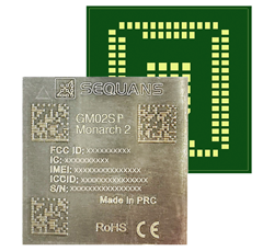
Nestwave is collaborating with Sequans to deliver accurate and efficient GNSS positioning for low-power internet of things tracking
The Nestwave IP provides the latest Sequans LTE-M/NB-IoT platform with geolocation. (Photo: Sequans)
Nestwave has announced that its technology has been selected by Sequans Communications S.A., provider of 5G/4G cellular internet of things (IoT) connectivity solutions. Specifically, Nestwave’s technology will add GNSS positioning to the Sequans Monarch 2 LTE-M/NB-IoT platform.
Integrated into the Sequans Monarch 2 GM02SP module, the Nestwave GNSS solution offers Sequans’ IoT customers accurate positioning with ultra-low-power consumption while minimizing component count, cost and size by removing the need for an external positioning chipset.
This makes the Sequans platform suitable for a wide variety of intermittent, power-limited tracking use cases including personal trackers, parcel and pallet location, and fleet trackers, as well as car, bike and scooter location and theft recovery. Cosmo Connected, a leader in urban mobility solutions, has already adopted the Monarch 2 GM02SP solution to reduce the cost and power consumption of its tracker products.
Nestwave’s technology allows geolocation to be added to existing IoT chipsets by implementing a GNSS receiver using the chip’s existing radio and computing capabilities. This eliminates the need for an external GNSS chipset and product redesign.
“Nestwave’s technology provides the smallest, most power efficient, and lowest component count solutions for IoT geolocation,” said Nestwave CEO Ambroise Popper. “Our strategic partnership with Sequans addresses the challenge of integrating accurate geolocation into compact, often battery-powered, low-cost IoT nodes and allows Sequans customers to benefit from higher performing, lower cost tracking solutions.”
“Leveraging Nestwave’s innovative technology to provide low-power GNSS on Monarch 2 widens its capabilities and makes many types of IoT tracker use cases more affordable because there is no need for additional positioning chips or modules,” said Georges Karam, Sequans CEO.
Nestwave IP has been integrated into a variety of chip architectures and on various DSP/CPU cores. In combination with Nestwave cloud services, this IP enables a very short time-to-first-fix, which allows for much lower power consumption in tracking use cases, without compromising on sensitivity or accuracy. The company’s technology roadmap includes the addition of 5G/4G cellular-based hybrid location functionality and solutions that will improve the accuracy of indoor tracking.
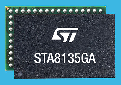
STMicroelectronics has introduced an automotive satellite-navigation chip designed to deliver high-quality position data needed by advanced driving systems.
Joining ST’s Teseo V family, the STA8135GA automotive-qualified GNSS receiver integrates a triple-band positioning measurement engine. It also provides standard multi-band position-velocity-time (PVT) and dead reckoning.
The STA8135GA’s triple-band enables the receiver to efficiently acquire and track the largest number of satellites in multiple constellations simultaneously for superior performance in difficult conditions such as in urban canyons and under tree cover.
Triple band has historically been used in professional applications such as surveying, mapping and precision agriculture that demand millimeter accuracy with minimal reliance on correction data, usually available on larger and more expensive modules than ST’s single-chip STA8135GA.
The compact STA8135GA will help driver-assistance systems make accurate decisions about the road ahead. The multi-constellation receiver delivers raw information for the host system to run any precise-positioning algorithm, such as PPP/RTK (precise point positioning/real-time kinematic). The receiver can track satellites in the GPS, GLONASS, BeiDou, Galileo, QZSS and NAVIC/IRNSS constellations.
The STA8135GA also integrates separate low-dropout voltage regulators on chip to supply the analog circuitry, digital core and input/output transceivers, simplifying selection of the external power supply.
The STA8135GA also enhances the performance of in-dash navigation systems, telematics equipment, smart antennas, V2X communication systems, marine navigation systems, drones, and other vehicles.
“The high precision and single-chip integration delivered by the STA8135GA satellite receiver enables the creation of reliable and affordable navigation systems that enable vehicles to be safer and more context aware,” said Luca Celant, general manager, ADAS, ASIC and Audio Division, Automotive and Discrete Group, STMicroelectronics. “Our unique in-house design resources and processes for high-yield manufacturing are among the critical capabilities that have made this industry-first device possible.”
The STA8135GA is housed in a 7 x 11 x 1.2 BGA package. Samples are available now and full qualification AEC-Q100 and Start Of Production are scheduled for the first quarter of 2022.
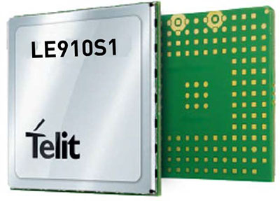
Telit, a global enabler of the internet of things (IoT), has launched the LE910S1-ELG, a new LTE Cat 1 module designed for IoT applications in Latin America (LATAM) that need a combination of performance, affordability, voice support and 2G fallback in a compact form factor.
With an embedded GNSS receiver, the cost-optimized LE910S1-ELG is suitable for tracking applications such as fleet management, stolen-vehicle tracking and recovery, and other mobile IoT applications that need to maintain a reliable connection when moving around in a country, region or multiple regions.
The LE910S1-ELG is the latest member of Telit’s flagship xE910 module family, whose unified form factor and electrical and programming interfaces spanning 2G, 3G and 4G products enables developers to implement a “design once, use anywhere” strategy. The module supports LTE Cat 1 with single-antenna reception, providing downlink speeds of up to 10 Mbps and uplink speeds up to 5 Mbps. Its streamlined configuration, compared to LTE Cat 1 devices with two antennas, helps significantly reduce cost and complexity.
Supporting 2G fallback, the LE910S1-ELG is suitable for applications that require full mobility throughout the LATAM regions, including areas that have not upgraded to 4G yet. It also supports both circuit-switched voice and VoLTE for those applications that require making phone calls, such as healthcare mobile personal emergency response systems (mPERS), connected elevators, alarm systems and more. The power-saving embedded GNSS receiver enables the use of GNSS positioning even when the cellular modem is switched off.
“The LE910S1-ELG is a great option for migrating customers that use legacy 2G and 3G modules in Latin America, especially where nationwide LTE-M and NB-IoT coverage does not yet exist,” said Marco Stracuzzi, head of product marketing, Telit. “Our all-in-one cellular and GNSS module covers all LATAM 4G and 2G bands, as well as mainstream bands used in Europe and Asia, which makes it well-suited particularly for high-performance tracking across intercontinental deployments.”
The LE910S1-ELG is sampling now, and will be commercially available during the first quarter of 2022.
Upgraded range of synchronization solutions now includes enhanced PNT resiliency against jamming and spoofing attacks and cyberthreats
ADVA has announced a new software release of its core and edge timing technology, to provide higher levels of positioning, navigation and timing (PNT) security and resilience to synchronization networks. The new release follows the Resilient PNT Conformance Framework issued by the U.S. Department of Homeland Security (DHS).
The upgraded series of PTP grandmaster clock solutions now enables operators to automatically harness public key infrastructure. Along with enhanced certificate management, this delivers more robust security and removes complexity, the company said.
ADVA’s core and mid-sized PTP grandmaster devices now also integrate enhanced aPNT+ technology, providing advanced jamming and spoofing detection as well as mitigation with automatic switchover in the event of cyberattacks.
The software replaces costly hardware devices previously used for PNT protection and achieves enhanced DHS Level 4 Resiliency in PNT self-survivability, the highest in the industry. The new software release also supports 100 Mbit/s over fiber for interconnectivity with optical timing channels from third-party vendors as well as support for PTP profiles for a wide range of industries.
“Today’s timing networks require greater accuracy than ever before. But mission-critical national networks need improved resilience and security as defined by the latest standards. With our trusted PNT assurance solutions, we’re providing the GNSS protection and cybersecurity that today’s operators need to meet current and future challenges,” said Gil Biran, GM of Oscilloquartz, ADVA. “From phase synchronization in critical national infrastructure to traceable timestamping in financial networks, highly precise and protected timing is key to successful operations. This upgrade sets a new standard for secure synchronization and delivers it to more networks than ever before.”
The new 11.1.1 software release features upgrades to ADVA’s comprehensive range of Oscilloquartz edge timing products, the OSA 5412/22 series, as well as its core synchronization devices, the OSA 5430/40 series. The solutions now provide multi-layered security for synchronization infrastructure through improved certification management and PKI.
As part of ADVA’s intelligent and scalable assured PNT platform, the ADVA aPNT+, the solutions also feature innovation for detection of spoofing and jamming as well as countermeasures to prevent service disruption. With PTP capabilities for new verticals, including the PTP broadcast profiles (SMPTE ST-2059-2/AES67), the new release will bring precise, reliable synchronization to many new customers.
China and the Arab states will expand their cooperation in using the China-developed BeiDou Navigation Satellite System (BDS), according to the third China-Arab States BDS Cooperation Forum and reported by XinhuaNet.
China and the Arab states will jointly implement pilot projects in key domains in the application of BDS and GNSS over the 2022-2023 period, according to a cooperation action plan signed at the forum, held Dec. 8 in Beijing.
Both sides will facilitate the establishment of BDS/GNSS centers in the Arab states, hold training courses on satellite navigation technologies, and exchange visiting scholars. Each year, China will offer scholarships to three to five students majoring in navigation and communications from the Arab states, said the action plan.
China and the Arab states will also carry out joint BDS/GNSS tests and evaluations, and promote the application of BDS in international search and rescue, among other initiatives.
All the moves are expected to boost “win-win cooperation” and make BDS better serve the Arab states, said the action plan.
This year’s forum was held after China officially commissioned BDS on July 31, 2020, opening the new BDS-3 system to global users.
Along with positioning, navigation and timing services, the BDS-3 system can provide a variety of value-added services such as global search-and-rescue assistance, short message communication, ground- and satellite-based augmentation, and precise point positioning.
The forum highlighted the achievements and experience of China and Arab states in BDS/GNSS cooperation and proposed a platform for both sides to upgrade the win-win cooperation.
BeiDou benefits in Arab States
The BDS-based applications and solutions have benefited multiple industries in Arab states. BDS has been providing real-time, continuous, stable and precise GNSS positioning information data and timely information via continuously operating reference stations (CORS) in Tunisia, Algeria and other places.
High-precision BDS/GNSS applications are also serving diverse fields such as land mapping, transportation, precision agriculture and environmental monitoring.
Project management of railway construction in the United Arab Emirates (UAE) has benefitted from the integrated technologies of BDS/GNSS and the internet of things, with efficient use of data and information.
BDS has entered a new phase of industrial and international development, according to the China Satellite Navigation Office.