Tim Burch is a contributing editor to GPS World’s Survey Scene newsletter, authoring columns six times a year.
Burch is a professional land surveyor (PLS) licensed in Illinois and Wisconsin. He has been involved with NSPS for more than 20 years as secretary of the board of governors as well as the board of directors, NSPS vice president, a member of the Certified Survey Technician Board, Joint Government Affairs and American Land Title Association (ALTA)/NSPS Land Title Survey committees. Along with content contributor for NSPS social media, he is creator and producer of the NSPS podcast “Surveyor Says!” and a contributing writer to the NSPS newsletter “News and Views.”
Burch has been involved with the land surveying profession for more than 30 years and has represented NSPS at numerous functions and conferences. He has provided testimony on behalf of the profession at both the state and federal levels as well as helping establish a partnership with “Get Kids into Surveying.”
He is currently chair of the International Federation of Surveyors (FIG) Working Group 1.1 (Professional Ethics) and is chair-elect for FIG Commission 1 (Professional Standards).
Burch succeeded Curt Sumner, who was executive director for the past 23 years.
The Global Positioning System (GPS) is “still a significant single point of failure in our country,” said Caitlin Durkovich, National Security Council director for Response and Resilience.
Her remarks were made at the Dec. 9 meeting of the president’s National Space-based Positioning, Navigation and Timing (PNT) Advisory Board.
Durkovich’s remarks were made in the context of a larger national resilience message. She cited recent incidents such as Hurricane Ida, the Colonial Pipeline hack, the winter failure of the Texas electrical grid, and disrupted supply chains. She said everyone is responsible to ensure they, their systems and the nation are able to safely weather adverse events and bounce back better than before.
The interconnectedness of so many vital services such as electrical power and other vital systems like PNT make a holistic approach necessary. The administration is developing a set of resilience principles to support that, she said. It is also ensuring as funds go out to states and localities from the infrastructure bill that making American infrastructure more resilient to climate change and “all hazards” is a priority.
Because “positioning, navigation and timing is foundational to our life,” she said, “resilience is more important now than ever.” Disruptions could lead to “cascading effects.”
Durkovich cited the administration’s Space Priorities Framework as evidence of White House concern. Released this month, it says in part:
“Space systems are an essential component of U.S. critical infrastructure — by directly providing important services and by enabling other critical infrastructure sectors and industries. The United States will enhance the security and resilience of space systems that provide or support U.S. critical infrastructure from malicious activities and natural hazards.”
She also indicated that the Biden administration was following through on two Trump administration policies as important steps to resilience.
Executive Order 13905, “Strengthening National Resilience Through Responsible Use of Positioning, Navigation, and Timing Services,” among other things, calls on all users to avoid over-reliance on GPS. It also calls for the federal government to require PNT resilience to be considered when selecting contractors.
Space Policy Directive 7 “The United States Space-Based Positioning, Navigation, and Timing Policy” outlines a number of research and other efforts. It also says the nation will:
“Invest in domestic capabilities and support international activities to detect, mitigate, and increase resilience to harmful disruption or manipulation of GPS, and identify and implement, as appropriate, alternative sources of PNT for critical infrastructure, key resources, and mission-essential functions.”
Several board members asked about the Federal Communications Commission’s (FCC) order authorizing Ligado Networks to broadcast in frequencies adjacent to those used by GPS. She said the administration was concerned and both the National Economic Council and National Security Council were in discussion. Engagement with the FCC, though, may pend confirmation of a full board of commissioners.
One of the board members asking about the Ligado issue followed up with a comment that adjacent-band concerns pale in comparison to recent Russian threats to GPS satellites. Durkovich responded that there wasn’t much she could say on that topic in public except that it had the attention of the president and his senior advisors.
Durkovich was also asked about the administration’s commitment to execute the 2018 National Timing Resilience and Security Act. The law’s requirement to establish a terrestrial, wireless source of coordinated universal time to back up GPS signals by December 2020 was ignored by the Trump administration.
Her reply was to reaffirm her earlier statement that “assuring positioning, navigation and timing, and the economic and strategic benefits it brings to this nation, is a priority for this administration.”
Video of the entire advisory board meeting is available on YouTube. MS Durkovich’s remarks begin at approximately 1:37:00. A link to the video is also posted as part of the agenda on the board’s website.
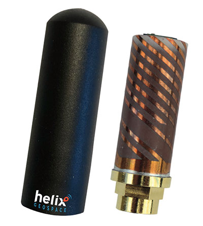
Helix builds precision GNSS antennas that enable product designers to create small, accurate positioning, navigation and timing (PNT) synchronization products that defend against vulnerabilities and threats. Helix is also developing its antennas to provide navigation for autonomous vehicles.
Helix’s patented DielectriX antennas are targeted initially to receive PNT signals from GNSS (GPS, Galileo, GLONASS, Beidou) constellations, and the Satelles STL (Satellite Time and Location) signals delivered over the Iridium constellation as well as Iridium’s voice and data network.
Future antenna variants will support low-Earth orbit (LEO) PNT services being planned and built by private companies, as well as government agencies, the company said.
DielectriX antennas discriminate true satellite signals from multipath signals, interference and jamming, delivering high performance in a compact and rugged form factor. Helix’s customers include defense, automotive, aerospace and critical infrastructure companies.
Helix previously raised £2.5 million from UKI2S and angel investors, and has participated in Wayra UK’s Intelligent Mobility Accelerator programme and Seraphim Capital’s Space Camp Mission 6. Helix also received additional grant funding for advanced antenna development from the European Space Agency, and for anti-jamming/spoofing technology from UKI2S.
Artist’s rendering of GPS IIF satellite. (Image: U.S. Air Force )
Boeing has secured a 10-year, $329.3 million contract to help the U.S. Space Force engineer operational GPS Block IIF satellites, the Department of Defense announced Dec. 20.
The company will perform engineering work to support on-orbit operations of the Block IIF satellites, which were manufactured by Boeing.
Space Systems Command issued the indefinite-delivery/indefinite-quantity contract to address GPS IIF mission requirements across the military and expects work to conclude by Dec. 20, 2031.
The U.S. Air Force deployed the first Boeing-built IIF satellite in May 2010 and launched the 12th and final satellite in February 2016.
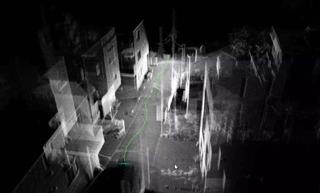
Tokyo-based Kudan Inc. demonstrated the use of a 3D-lidar simultaneous localization and mapping (SLAM) device to create a sharp point cloud without using an external GNSS receiver or inertial measurement unit (IMU).
Kudan is a research and development company specializing in algorithms for artificial perception. For the demonstration, Kudan used its localization and mapping software Kudan 3D-Lidar SLAM, or KdLidar.
Using an Ouster OS1-64 lidar and only its internal IMU, Kudan demonstrated how it can create a crisp high-resolution point cloud with KdLidar.
For the demonstration, the company used a handheld scanner with the Ouster lidar. Handheld scanners can introduce noise and fuzziness in typical point clouds generated from SLAM because of natural vibration, movement and limited field of view. However, Kudan was able to capture sharp wall definition of buildings and structures, as well as the fine detail of powerlines.
While the demonstration highlights KdLidar’s basic performance without any external sensors, the company said its algorithms can further increase the performance and quality of lidar-based scanners by fusing GNSS receivers and external IMUs or inertial navigation systems.
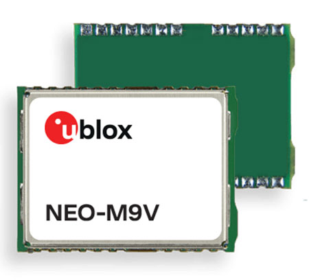
U‑blox has announced the NEO-M9V module, its first GNSS positioning receiver to offer both untethered dead reckoning (UDR) and automotive dead reckoning (ADR).
The NEO-M9V is suitable for fleet management and micro-mobility applications that require reliable meter-level positioning accuracy even in challenging GNSS signal environments such as urban canyons.
Using inertial sensor measurements, UDR offers a smooth navigation experience in dense urban environments by bridging gaps in GNSS signal coverage and mitigating the impact of multipath effects caused by GNSS signals that bounce off buildings. ADR further increases positioning accuracy in demanding environments by including the vehicle speed in the sensor-fusion algorithm.
Offering both UDR and ADR on the same module delivers maximum positioning performance and design flexibility, u-blox said. The NEO-M9V also features dynamic models optimized for both cars and e-scooters.
NEO-M9V is based on the u‑blox M9 GNSS technology platform. Its ability to track up to four GNSS constellations maximizes the number of GNSS satellites within its line of sight at any given moment. Integrated SAW and low-noise amplifier filters offer excellent interference mitigation for a robust solution. Compatibility with the NEO form factor reduces migration efforts for customers upgrading existing designs.
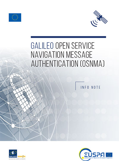
An Info Note has been published with analytical information on the Galileo Open Service – Navigation Message Authentication (OSNMA). The note is available on the European Union Agency for the Space Programme (EUSPA) website or through the European GNSS Service Centre. To contribute to the detection of GNSS jamming and spoofing attacks, EUSPA together with the European Commission is testing OSNMA.
This forthcoming service is an authentication mechanism that allows Open Service users to verify the authenticity of GNSS information, making sure that the data they receive is indeed from Galileo and has not been modified in any way.
OSNMA is authenticating data for geolocation information from the Open Service through the Navigation Message (I/NAV) broadcast on the E1-B signal component. This is realized by transmitting authentication-specific data in previously reserved fields of the E1 I/NAV message. By using these previously reserved fields, OSNMA does not introduce any overlay to the system, thus the OS navigation performance remains untouched.
Authentication is set to further strengthen service robustness by increasing the capability of detecting spoofing events. However, it should be kept in mind that authentication does not prevent the occurrence of such an event, and does not protect against jamming. Nonetheless, this added layer of protection proposes to be one step ahead of evolving technological trends by amplifying the service’s overall robustness and resilience.
The Air Force Research Laboratory’s complementary positioning, navigation and timing (PNT) AgilePod prototype achieved three important objectives in flight tests conducted at Edwards Air Force Base Nov. 1-10, 2021.
PNT AgilePod helps develop advanced navigation technology independent of GPS, according to Maj. Andrew Cottle, Air Force Strategic Development Planning and Experimentation (SDPE) office. This technology provides reliable, resilient PNT navigation signals through alternative means, increasing mission effectiveness in scenarios where access to GPS is not guaranteed.
The test team — representing a broad base of Air Force, Navy and vendor organizations — successfully executed eight sorties aboard a T-38C aircraft, which included:
the first test of the PNT AgilePod on a high-dynamic-range platform
the first test of fully remote interfacing and alt-PNT data transmission
the first demonstration of overland/overwater transition performance.
He said the tests demonstrated the operational utility of a fused alt-PNT system incorporating multiple technologies within a single government-owned open-architecture prototype.
A PNT AgilePod attached to a T-38C successfully demonstrated remote interfacing and alt-PNT data transmission, as well as performance over land and water. (Photo: USAF/2nd Lt. Bowen Lin, 586th Flight Test Squadron)
AgilePods Designed for Flexibility
AgilePods are comprised of a series of compartments and can be configured to meet a wide variety of mission requirements for many aircraft platforms. Experimenters can fill the spaces with plug-and-play sensors they need for a mission — high-definition video, electro-optical and infrared sensors, and devices with other capabilities — including PNT.
The AgilePod has an open hardware architecture. For the complementary PNT prototype, it was combined with an open software architecture that allows a wide variety of alternative PNT technology to integrate and pass information. These capabilities enable rapid integration of sensor technologies through standardized software and hardware interfaces, allowing the pod to seamlessly integrate on platforms that leverage the standard architectures.
In this way, one pod can perform hundreds of different mission sets with additional benefits of cost savings and increased sustainability, Cottle said.
The project directly supports the AFRL PNT Enterprise and the Air Force PNT Cross-Functional Team as they work to ensure reliable navigation within GPS-contested operational scenarios critical to the success of future Air and Space Force missions.
A PNT AgilePod attached to a T-38C successfully demonstrated remote interfacing and alt-PNT data transmission, as well as performance over land and water. (Photo: USAF/2nd Lt. Bowen Lin, 586th Flight Test Squadron)
Managing live sky and terrestrial time sources to protect critical infrastructure against cybersecurity threats
By Greg Wolff, Microchip Technology
Critical public infrastructure systems that rely on GNSS for reception of positioning, navigation and timing (PNT) data have been identified by national security agencies across the globe as potential cybersecurity attack vectors. Late in 2020, the U.S. Department of Homeland Security (DHS) published the “Resilient PNT Conformance Framework” guidelines, providing a common reference point to help critical infrastructures become more resilient to PNT attack threats. Within the framework, a cybersecurity approach has been proposed.
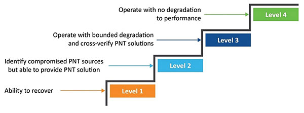
Prevent. In this first layer of defense, threats are prevented from entering a system. However, it must be assumed that it is not possible to stop all threats.
Respond. Atypical errors or anomalies are detected and action taken, such as mitigation, containment and reporting. The system should ensure an adequate response to externally induced, atypical errors before recovery is needed.
Recover. The last line of defense is returning to a proper working state and defined performance.
Figure 1. The four levels of resilience defined in the DHS “Resilient PNT Conformance Framework” guidelines. (Image: Microchip)
Four Levels of Resilience
Based on the Prevent-Respond-Recover cybersecurity model, the PNT Conformance Framework document describes four levels of resilience. Note that the resilience levels build upon each other — Level 2 includes all enumerated behaviors in Level 1, and so forth.
The framework provides a clear set of PNT resilience guidelines for equipment, whether at the silicon, module or system level. Although the framework is not specific to the use of GNSS, much of the focus has centered on GNSS vulnerabilities and the ability to be resilient to GNSS outages, whether caused by unintentional disruptions or intentional threats. However, the GNSS resiliency of specific equipment or technology does not fully address the needs of critical infrastructure operators who are managing the use of PNT services over large geographical areas.
Critical Infrastructure Expansion
Critical infrastructure is typically constructed in a tiered manner, beginning with a set of core sites connected to secondary sites that are ultimately connected to remote sites. With the rollout of 5G networks, densification and massive deployment of wireless access points will improve coverage and enable higher bandwidths to support the internet of things (IoT) and related services. However, this massive scale of access points will also require accurate timing at a much larger number of endpoints.
Within the power utility infrastructure, the power grid is being augmented and expanded with alternative energy sources, such as solar and wind. The modernized smart grid is a highly distributed architecture that is dependent on accurate timing for coordination, monitoring and logging of data for operation and identification of power-outage fault detection. Additionally, power utilities rely on timing services for communications and transport of telemetry data throughout their entire operations.
To date, GNSS has been the go-to source for timing, creating an exponential increase in the dependency on GNSS. Because of this massive dependency, the impact of errors or interruptions today is more significant than ever before.
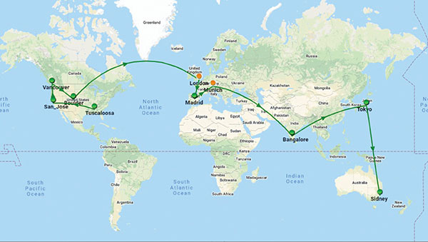
Figure 2. Example view of timing network at data centers across the globe. (Image: Microchip)
Terrestrial Time Distribution
As an alternative for delivering accurate time to large numbers of locations and reducing dependency on GNSS, critical infrastructure operators are turning to the use of terrestrial distribution using packet protocols so that high accuracy distribution can be achieved using Precision Time Protocol (PTP).
The virtual Primary Reference Time Clock (vPRTC) is a highly secure and resilient network-based timing architecture developed to meet the expanding needs of modern critical infrastructures. The vPRTC is simple in concept. It blends proven timing technologies into a centralized and protected source location, and then uses commercial fiber-optic network links and advanced IEEE 1588 PTP boundary clocks to distribute 100-ns PRTC timing where it is needed in end points that might be hundreds of kilometers away.
Just as a GNSS-satellite-based timing system distributes timing to end points using open-air transmission, the vPRTC distributes timing using a terrestrial (typically fiber) network. The difference is that the operator remains 100% in control of the network and can secure it as necessary. This network-based timing is referred to as trusted time. It can be distributed as the primary source of timing or it can be deployed as a backup to GNSS timing solutions.
Even with the many reliability and security benefits of the vPRTC approach, however, sole dependency on terrestrial time can become a single point of failure, just like a strategy dependent solely on GNSS. Because of this, critical infrastructure operators are deploying architectures that use both GNSS and terrestrial time. To do this effectively, operators find themselves with the need to have centralized management and visibility of both key sources of time. Further, to deliver on the promise of timing resiliency, a unified management system needs to include capabilities that can deliver a cybersecurity solution encompassing the Prevent-Respond-Recover DHS security guidelines across all nodes of the timing network.
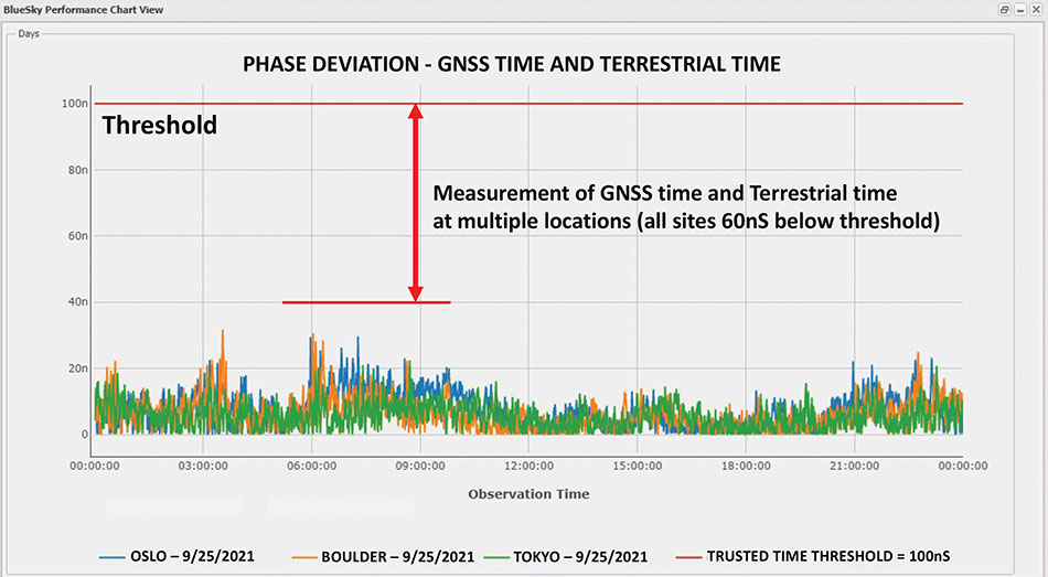
Figure 3. A measurement of phase difference between GNSS time and terrestrial time. (Image: Microchip)
Unified Time Management
Having a bird’s eye view of all nodes of a timing network is essential for providing timing security and resiliency. In the case of a GNSS anomaly or terrestrial time instability, when a problem occurs the most immediate need is to quickly identify whether the event is isolated to a specific location, affects a region, or in some cases is caused by a global situation. A centralized management and monitoring system provides a green, yellow and red threat-status indication representing different locations of interest. It is a simple way for operators to know the overall health of their timing infrastructure.
When problems surface, critical infrastructure operators next need visibility of “observables” that can quickly isolate the root cause. With today’s timing networks relying on both GNSS time and terrestrial time, the ability to see observables that represent both timing sources in a unified manner is critical.
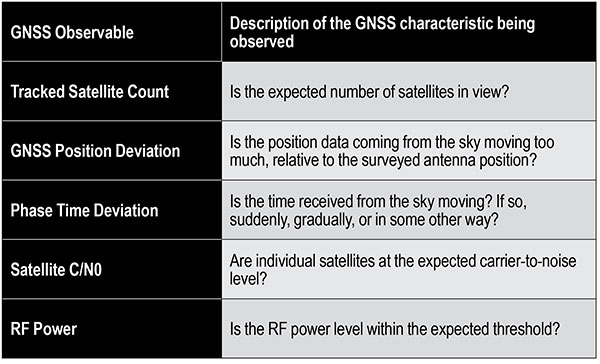
GNSS Observables
Multipath interference, weather anomalies, jamming and spoofing are terms commonly used when referring to GNSS vulnerabilities. Gaining insights (visibility) into the details to identify the root cause, however, requires more specific characterization of the signal.
Visibility into the quality of GNSS reception is accomplished by monitoring GNSS observables. Table 1 provides a sample of key GNSS observables that can be tracked and monitored.
Table 1. Sample of key terrestrial time GNSS observables.
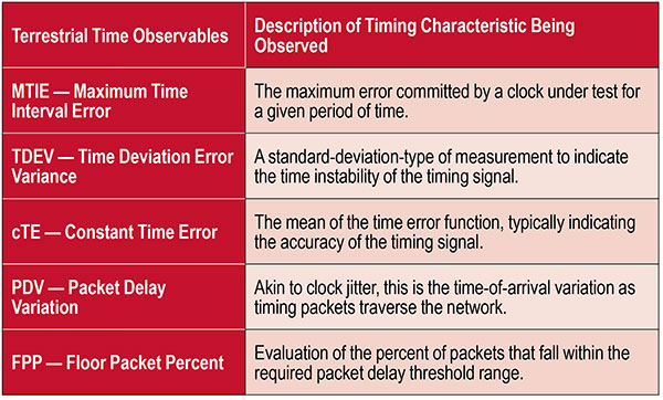
Terrestrial Time Observables
Characterizing the quality of terrestrial time requires time measurements between equipment interconnections within a single location (intra-office) or across nodes of a network (inter-office) — for example, comparison of equipment inputs and outputs or comparison of signals at different sites.
Additionally, with the standardized use of PTP, the ability to evaluate network timing packet metrics is needed to verify time transfer from location to location. Terrestrial time performance calls for a different set of observables to be made visible and monitored. Table 2 provides a sample of key terrestrial time observables.
When managing a large geographical area, being able to measure the phase difference between GNSS time and terrestrial time at multiple locations simultaneously enables an operator to determine how well these two sources of time compare. As described previously, critical infrastructure operators are ultimately in need of resiliency, which can best be achieved using both time sources.
Measuring the two sources against each other at multiple locations creates the highest level of trust knowing that these independent time sources are well aligned.
Table 2. Key terrestrial time observables that must be made visible and monitored.
Conclusion
With cooperation from industry, standards organizations and government organizations such as DHS, the use of timing services has become recognized as a foundational technology for critical infrastructure operations. Leveraging industry-standard cybersecurity models will help strengthen and harden timing equipment.
Although equipment resiliency is vital, having a bird’s eye view of timing performance across the entire network is the starting point for providing complete network visibility that is critical to providing timing security and resiliency. To deliver on the promise of timing resiliency across critical infrastructure, operators need a unified management system that enables simple and complete visibility of both GNSS and terrestrial time observables.
With a unified management of these two timing sources, operators have a platform to apply Prevent-Respond-Recover to timing threats and achieve the highest levels of resiliency and cybersecurity protection.
Greg Wolff is senior product line manager of Frequency & Time Systems at Microchip Technology. He has worked in the time and frequency industry since 1988 and was an early pioneer in the marketing of network synchronization solutions to major critical infrastructure operators across the globe. He is an active contributor to emerging standards supporting PNT resiliency and most recently, as part of Microchip Technology’s Frequency and Time Systems group, launched the BlueSky GNSS Firewall. He holds a degree in engineering science from California Polytechnic State University – San Luis Obispo.
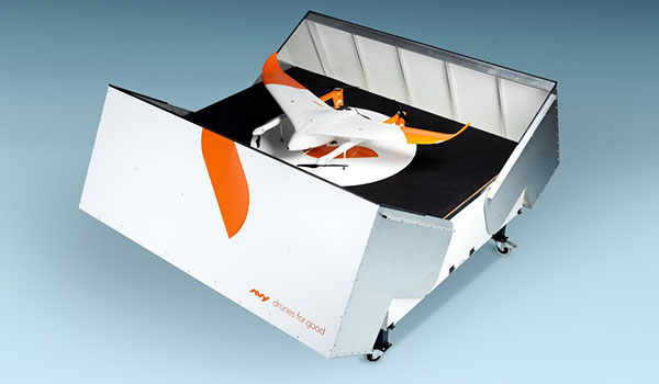
The Avy Aera departs from its docking station within minutes, shortening response times and reducing costs for first responders. (Photo: Avy)
Dutch company Avy has launched its Drone Response Network, combining docking stations with autonomous aircraft that have vertical take-off and landing (VTOL) capabilities.
The network offers drone coverage in a certain area, enabling instant deployment to support medical deliveries or emergency services during critical incidents.
First flights are expected to take place in the first quarter of 2022.
The network uses the Avy Aera autonomous drone that can carry up to 3 kg of medical goods over a distance of 100 km. It can operate year round, in rain and winds up to 45 kph, and is designed to meet the latest European Union drone regulations and United Nation requirements for aerial transport of medical goods.
For medical delivery, the drone is equipped with Aera’s Medkit, which has a four-liter capacity and is fitted with sensors for immediate assessment. Medical products remain cooled at 2-6 degrees for at least 100 minutes in an ambient temperature of up to 40° C.
The Avy Drone Response network is suitable for both urban and rural areas, delivering medicines, blood products, vaccines and other medical applications safer and twice as fast as road transportation, and is more environmentally friendly. It is expected to make a substantial contribution to achieving the goal of connecting hospitals and laboratories by air by 2023.
The Avy Aera can also be integrated with a high zoom RGB and thermal camera system and used to quickly detect wildfires, spot people in distress at sea, monitor oil spills and assess the situation on the ground.
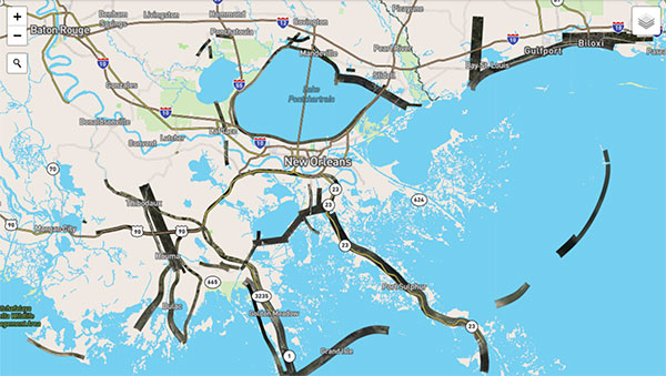
Hurricane Ida assessment imagery and data are now available. Ida was a Category 4 Atlantic hurricane from Aug. 26 to Sep. 4. (Screenshot: NOAA)
Applanix, a Trimble Company, and the National Oceanic and Atmospheric Administration (NOAA) have collaborated to provide critical information to first responders in the wake of Hurricanes Henri and Ida.
Applanix’s high-accuracy direct georeferencing (DG) technology enabled NOAA to quickly collect aerial mapping imagery to
provide valuable disaster remediation information to first responders
demonstrate the value of mapping technology in preparing for and responding to emergency situations such as hurricanes, tornadoes and other disasters.
Within hours of Hurricanes Henri and Ida making landfall, NOAA’s National Geodetic Survey collected post-storm imagery using the latest generation Digital Sensor System (DSS). The sixth-generation DSS, designed and manufactured for Applanix by Lead’Air, is the most powerful to date, thanks to several new features introduced within the solution:
simultaneous full color and near-infrared image capture using high-performance Phase One iXM 100 MP NIR and 150 MP RGB cameras
option to fly the cameras in wide coverage oblique or traditional overhead (straight line down) mode for mapping with uninterrupted measurement
embedded Trimble AP60 GNSS + inertial OEM DG solution for mapping without the need for ground control or aerial triangulation
Applanix POSPac post-processing software featuring the Trimble post-processed CenterPoint RTX correction service (PP-RTX) for centimeter-level mapping without GNSS reference stations
in-air development of raw imagery to JPEG-ready files for creating map products immediately upon landing
Lead’Air’s X-Track flight management, which enables the system to be flown outside of planned flight lines to follow roads, rivers and coastlines.
Applanix’s DG technology suite provides direct GNSS inertial georeferencing, meaning that all pixels in the aerial images taken by NOAA are mapped at their exact location on the ground.
“We have worked with Applanix for nearly 20 years,” said Michael L. Aslaksen Jr., chief of the remote-sensing division, NOAA’s National Geodetic Survey. “The level of sophistication they bring to aerial imagery and mapping keeps our team at the forefront of the industry. Their customer support team is always open to new ideas, new innovations and doing whatever it takes to get the job done.”
First responders have access to this imagery and mapping within 24 hours via the cloud (as does anyone at storms.ngs.noaa.gov) and can map detailed response plans based on highly accurate data highlighting where the greatest need lies.
Access to this turnkey emergency response imagery is available to any federal agency, municipality, insurance company or other entity that depends on highly accurate information to plan for and recover from disasters.
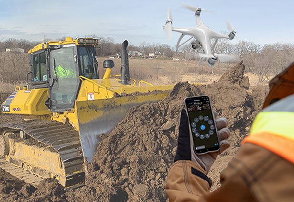
Heavy-equipment maker Komatsu has added two new “smart” products to its job-site solutions for construction contractors, Smart Construction Field and Smart Construction Drone.
Smart Construction Field
Komatsu has partnered with Moovila, an experienced provider of project management software, to develop Smart Construction Field, a mobile app that allows contractors to easily record job site activity and analyze operational efficiencies in near real time.
Reports generated by Smart Construction Field can track daily job-site conditions. Task progress can be broken down by labor, equipment and materials, including machine utilization and fuel distribution, receipts, timecards and subcontractor work. Regardless of equipment brand, Smart Construction Field can collect machine data from an entire fleet.
Smart Construction Drone
Smart Construction Drone survey technology collects accurate topography, including quantities for production tracking and billing, without personnel walking the job site to do a manual survey.
Contractors can gather and analyze data throughout each project phase with topographic surveys that incorporate hundreds of thousands of data points. With the capability to take still photos from up to 400 feet above ground level or under bridge decks, Smart Construction Drone can be used as pre-job verification or to keep stakeholders up to date.
Smart Construction Drone is designed to work with Smart Construction Dashboard. Built to combine data from multiple sources into one comprehensive picture, Smart Construction Dashboard combines 3D design data with aerial mapping and intelligent machine data, allowing contractors to confirm quantities and visualize job-site progress.
Smart Construction Dashboard is powered by the 3D visualization power and geospatial accuracy of Cesium, a platform that visualizes, analyzes and shares 3D data.
Both Smart Construction Drone and Smart Construction Field are part of Komatsu’s Smart Construction solutions, an umbrella of smart applications created to help construction customers optimize their business remotely, and in near-real time.
“When the Smart Construction group came in, they integrated everything, and the transition felt seamless,” said Kevin Hawkinson, vice president of operations, A.W. Oakes & Son. “Now, we can take the data, transfer it to the machines, get data back from the machines to the office, and utilize all of that information across the board for bidding, customer reference and billing.”