Tony Murfin Contributing Editor, Professional OEM & UAV, GPS World
As the days tick down towards the always-anticipated Association for Unmanned Vehicle Systems International (AUVSI) Xponential convention in Denver May 1-3, the unmanned vehicle industry is preparing once more for one of its largest exhibitions.
More than 750 exhibitors will be spread over a huge 370,000-square-foot exhibit floor at the Colorado Convention Center and 8,500 visitors from unmanned systems and robotics are expected to come to share ideas, gain insights and carefully examine the unmanned innovations on show.
STEM Outreach. This year the show will not only feature industry innovation and growth, but will also highlight resources for potential science, technology, engineering and math (STEM) graduates with interactive and engaging content, including:
A buildathon/hackathon to conceive, design and build inventions during a timed competition prior to Xponential. Final projects will be displayed on the Xponential show floor as a representation of innovation and collaboration.
A dedicated area in the Xponential exhibit hall will describe the STEM education programs and services supported by AUVSI and the AUVSI Foundation to foster and cultivate the next generation of innovators and leaders.
An area of the show floor will also showcase the winners of student robotics competitions.
Denver area high school students will be invited to tour the exhibit area to introduce them to emerging unmanned technologies and applications.
A reception at the show promises to mix young professionals in unmanned systems with seasoned industry leaders, and finally,
The Women and Diversity in Robotics forum will feature speed networking with leaders to review STEM opportunities for career-focused women and girls.
Survive and Thrive. Meanwhile, the Denver exhibition will demonstrate how the rapidly evolving world of UAVs has encouraged “survive and thrive” for those new entrants who together seem to have adapted to address almost any and all opportunities. We’ll mention a couple of examples here, and attempt to provide a better cross section of the huge number of companies and products present following the actual show.
For instance, one of the drawbacks for small, predominantly electric-powered, multi-rotor UAVs is that their endurance is limited. Providing longer duration operations may be outside their envelope — for such longer term things as providing temporary mobile-phone signal coverage, or police/agency reconnaissance/search, or for larger vertical inspection jobs.
Presumably, floating one of several available models of lighter-than-air, blimp-type UAVs might be more expensive or cumbersome than using a multi-rotor unmanned vehicle, so overcoming power-supply issues would seem to be key. One way to do this is to attach a strong tether bringing power up from the ground.
Orion UAS. The Elistair (France) Orion UAS will no doubt be featured on the company’s booth. This multi-rotor UAV has been developed for longer term aerial surveillance and telecommunications operations. Typical users include law enforcement, private and public safety, national security, asset protection, emergency communications and crisis management, so these tethered drones are deployed by police forces, public security departments, public and private security companies, and governments in more than 30 countries.
Photo: Elistair
The Orion UAS uses industrial components and system redundancy, including autopilot sensors, motors, power distribution and logic controls, and has an emergency parachute system. The patented micro-tether system ensures a stable platform supplied with continuous power from the ground to enable up to 10 hours of endurance. The mechanical structure of the drone is designed to sustain strong winds with maximum stability. With system redundancies and automated emergency procedures, the user is able to focus on safety-critical missions and data collection, while the risk of human mistakes is reduced.
The onboard camera has both FLIR and optical, enabling night/day surveillance with gimbal stabilization and low latency — the 30x optical zoom makes it possible to detect a moving person from kilometers away. And the tether system provides high-speed, interference-free data transmission so the system is also virtually undetectable. It’s easy to see why tethered drones are becoming more popular for security applications.
Identifying UAVs. At the FAA Unmanned Aircraft Systems (UAS) Symposium last week in Baltimore, a key issue discussed concerned remote identification and tracking of drones. It would seem that the FAA is about to announce a new rule that could eventually clear the way for drones flying over people and beyond line-of-sight of their operators — and this may be a key topic of discussion at Xponential.
The FAA rule appears to mandate that every drone should in some way communicate its identification — presumably its FAA registration ID — so that its operator could also be known.
One well-known company, Ford, has already announced that it has a concept using onboard collision lights on a drone to optically signal the 10-digit FAA registration number to the ground for capture and decoding. Maybe other exhibitors at the show will have other solutions — perhaps radio based? We’ll see.
Sensefly eBee drone.
Sensefly’s eBee. At the sensefly booth, we may also hear about several interesting announcements on recent drone applications:
Products on display will include the RTK/PPK-enabled eBee Plus professional mapping drone, the eBee SQ drone for agricultural applications and the albris mapping and inspection drone, as well as the senseFly S.O.D.A camera and GeoBase.
In addition, senseFly sales manager and GIS scientist Briton Voorhees will deliver a presentation titled, “Comparing workflow and point cloud outputs of the Trimble SX10 TLS and senseFly eBee Plus drone,” on Wednesday, May 2, at 11 a.m. in the Mapping and Surveying Track.
Booth visitors can also find out more about senseFly’s comprehensive 360 solutions, which are designed to improve operational efficiencies and support decision-making in the surveying, mining and quarries, agriculture and inspection sectors.
And many more. GNSS players also expected to be at the show include Hemisphere GNSS, NovAtel, Rockwell-Collins, Septentrio, Tersus, Trimble, Accord/Aspen Avionics, Comnav, Navtech, Swift and Topcon, as well as GNSS chip manufacturers u-blox and Intel — although Intel may likely focus on its UAV/communications offerings at this show.
There will also be a number of antenna suppliers, inertial sensor manufacturers, UAV autopilot manufacturers and several ancillary electronics and mechanical systems suppliers — all trying to solidify their positions in the UAV vehicle and systems integration supply chain.
The major focus, as usual, will be on UAV/UAS vehicle manufacturers and system integrators and their products — there is always a great exhibition of actual UAVs from all sectors of the industry.
So, along with a parallel program of educational presentations on a wide range of industry aspects, the AUVSI Xponential convention promises to have plenty of opportunities to find things of interest to almost anyone, and many areas to focus on for experts already in the industry.
If a passenger-carrying drone could cost about the same as a regular passenger car, like those used by taxi and Uber drivers, then the economics might work. So it’s interesting that an outfit in the United Kingdom — Autonomous Flight — is talking about building passenger-carrying drones for around $25,000.
Autonomous Flight says has a prototype up and running, testing the concept in Southern England; testing with passengers is expected to get underway this year. The YS6 is battery-powered with multiple redundant systems for safety and is designed to fly at 70 mph, with a range of 80 miles at 1,500 ft.
This happens to meet a design goal of covering a distance from Heathrow Airport to Charing Cross train station in 12 minutes, a journey that would normally take around an hour by car in London traffic. There are similar “hops” that could save a massive amount of time in almost every city in the world.
But don’t hold your breath. It could take more than five years to get regulatory approval for the vehicle and for the initial routes over cities — never mind the time needed to get this particular concept into large-scale production to achieve the target price. But it’s nevertheless a good sign with good prospects for the future.
Drone Recovery System
While the U.S. Federal Aviation Administration (FAA) considers the regulations for drone flights over people, in the meantime several applications have been developed for people-overflight with drones equipped with parachutes.
Presumably, a drone would be safer if lowered by parachute in the event of equipment failure, but apparently such applications that rely on parachutes for risk mitigation have all been turned down by FAA. University of Alabama and Virginia Tech research has indicated a 70 percent chance of significant injury or death when a drone the size of an 8.85-pound DJI Inspire 2 fails and falls onto people.
Indemnis in Anchorage, Alaska, has been working with the FAA and other interested stakeholders to draft the regulatory standard for flight over people and has now gone on to develop its Nexus ballistic drone recovery system, which it plans to have on the market by next summer.
With a retail price of between $1,700 and $2,500, the system is expected to satisfy these coming FAA regulations for UAS flight over people and in urban areas for Part 107 commercial operations, but would seem to be quite expensive for smaller recreational drones.
The system is scalable for drones from eight pounds to “several thousand” pounds. The Nexus system is designed to automatically deploy within 30 milliseconds of detecting a failure on the drone or of entering unrecoverable flight, and the system is capable of determining normal flight or a failure to within six feet of vertical movement.
According to Indemnis, more than 10,000 requests for flight over people have been received by the FAA in the last 14 months, but all those that rely on parachutes for risk mitigation have been refused. This is apparently because conventional parachute systems have a tendency to become tangled with the aircraft or manual deployment is required. It is also said that current quadcopter drone safety systems — which cut power to an engine to prevent tumbling and which slow descent by adding power to the remaining engines — are inadequate for flying over people.
The Nexus system automatically detects failure, cuts engine power, and deploys an aircraft parachute within 30 milliseconds, slowing vertical speed to around 7 mph. This should be slow enough to allow the operator to catch up with the vehicle before it hits the ground. However, reducing vertical speed is only half the solution, as a vehicle under parachute will still travel horizontally due to wind velocity. So Indemnis is testing their parachute system with an airbag on a 33.29-pound DJI M600 drone. The airbag turns the drone “into a giant pillow” once the chute deploys.
The expected FAA standard is anticipated to require 45 tests in two failure modes — critical motor failure and full motor failure — at full flight speed, hover, and in automatic and manual deployment scenarios. Tests with a DJI Inspire 2 cutting one motor, two motors or four motors have pitched the drone violently just before it enters a slow roll — at 60 mph, it will roll quickly and violently.
This drone safety and recovery system is expected to be on the market within the next few years, following release of the projected FAA standards.
GoPro Karma hits the dust
In what would seem to be an unusual turn of events in a rapidly expanding market, GoPro has decided to exit the UAS vehicle business. GoPro cameras are still a favorite on a wide range of UAVs, but the company has chosen to get out of the business of making end-item unmanned vehicles, despite reaching second place in market share in 2017 for its price range.
At the Consumer Electronics Show (CES) Jan. 9-12 in Las Vegas, GoPro explained that its decision was based on inadequate returns versus the investment required to support their single-product UAS business.
However, Karma’s demise was apparently brought on not only by an expensive initial product recall, but also by the apparent additional financial pressure of poor Hero5 camera sales.
Nevertheless, GoPro still feels that the “action-camera” market has the legs to sustain growth, so it’s likely UAV manufacturers will not have to go looking for another reliable video camera source any time soon.
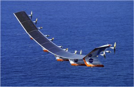
Joint venture for solar HALE UAS
The solar-powered Helios in flight.
In late 1990s/early 2000s, NASA contracted with AeroVironment to develop a high-altitude solar-powered UAS for NASA’s Environmental Research Aircraft and Sensor Technology, or ERAST, program.
In August 2001, the Helios prototype reached a world-record altitude of 96,863 ft., and in 2002 the Pathfinder Plus prototype provided from 65,000 feet high-definition television (HDTV) signals; third-generation (3G) mobile voice, video and data; and high-speed internet.
AeroVironment has now formed a joint venture with Japanese SoftBank Corporation to develop a solar-powered high-altitude long-endurance (HALE) UAS for commercial operations that may include applications such as high-altitude pseudo-satellites.
The joint venture — known as HAPSMobile — is a Japanese corporation in which AeroVironment holds minority ownership but is still able to directly exploit commercial and military opportunities outside Japan.
Summary
It’s encouraging to see another airborne taxi initiative joining the folks who were demonstrating prototypes in Dubai back last September. If the market is there, more entrants should help make this option a reality.
It’s also good news that a company already has a drone recovery system in the works that could reduce the potential for injury in the event one falls out of the sky. This might start to reverse adverse public opinion about drones and help the FAA move forward with regulations allowing wider usage.
Meanwhile, it’s sad but true that new industries inevitably see some entrants pull back and even leave in the early stages. It’s fortunate that popular drone camera supplier GoPro still has the ability to retrench and fall back on its existing business.
Finally, the promise of high-altitude solar-powered drones would seem to be still alive. If it could be possible to hang TV and other comms systems on these high-altitude loitering vehicles, there might be a much less expensive way of getting transmitters into very high altitude orbits without the cost of a space launch. Then many areas around the world could benefit from low-cost signal distribution that might not otherwise work commercially.
Drone operational rules have quite a few restrictions, largely aimed at keeping unmanned aircraft away from manned and commercial aircraft operations. The Federal Aviation Administration (FAA) has set a boundary limit for UAV operations to stay a minimum of 5 miles away from any airport. So it’s a little surprising that at least one airport is actually carrying on trials to fly drones within airport property.
The reason is birds. Most airports are large, open spaces where birds love to land in large numbers to seek food and to rest, so airports and aircraft have to cope with the problem of avoiding bird-strikes in the critical phases of take-off and landing.
Airports have used remotely compressed air cannons, and manually fired ordinance that “screams” or explodes making various forms of loud noise, or dogs or even hunting falcons of different species. Birds, however, become habituated to cannons and guns, and neither dogs nor hunting falcons can be relied on to actually herd birds away from runways.
All this is in an effort to drive flocks of birds away from runways and low-altitude aircraft traffic corridors. At high altitude, a bird strike is usually survivable and an aircraft still has sufficient energy to be able to glide in the event of a complete engine-out situation, giving the pilot time to find a landing place. U.S. Air’s Chesley Sullenberger was a great airman to save his passengers and aircraft, but he was also lucky to have the Hudson right there to ditch into. He was some cool dude when he put his Airbus A320 down on the river, once losing both engines at low altitude on take-off after flying through a flock of Canada Geese.
Enter Robird, a drone that looks — and behaves, in the right operator’s hands — like a female peregrine falcon, with flapping wing propulsion and attack moves emulating the predatory bird. Flown by a pilot and accompanied by an observer whose primary job is to ensure the UAV “bird” stays away from runways, the pair seeks resting flocks of birds that pose risk to aircraft within the boundaries of an operational airport.
https://youtu.be/-gc8kBmzOOI
Clear Flight Solutions in Holland has recently undertaken a trial at Edmonton airport in Alberta, Canada, where it obtained special flight clearance to fly within the airport grounds to demonstrate how its mechanical falcon could clear birds away from airport danger zones.
Of course, drones and aircraft don’t mix either, so flight rules within the drone systems (GPS/autopilot?) apparently include geofenced no-go areas corresponding with runways and approach areas, and there is a shutdown mode in case of loss of signal or other failure — avoiding runway incursion is all important.
Registration is back on
Since U.S. Federal Aviation Administration (FAA) regulations requiring registration of small UAVs (sUAV) and model aircraft were struck down last spring by the appeals court, the need to register has been in abeyance. However, Congress has rolled a new requirement back into the recently signed $700 billion National Defense Authorization Act, making registration of any sUAS or recreational model aircraft a legal requirement, subject to fines for lack of compliance.
The FAA has continued to advocate registration as a means to track wayward operators and to enforce separation of drones from manned aircraft. AUVSI has also continued to support the FAA position. A 2012 law, on the other hand, was said to prevent the FAA from making rules covering “model aircraft,” defined as “unmanned aircraft” flown for recreational purposes.
The new regulation within the Defense Authorization Act has now apparently clarified and overcome any contradictions — recreational model aircraft and drones all have to be registered.
DJI claims and counter-claims
The U.S. Immigration and Customs Enforcement’s (ICE’s) recent claims that manufacturer DJI could be spying for the Chinese Government have been refuted by DJI.
DJI has responded that allegations are wrong and that ICE should consider withdrawing or correcting unsupportable assertions. But claims persist that the Chinese government may be using information gathered by DJI UAVs to target potential assets for purchase.
A large wine producer in California used DJI UAS to survey its vineyards and monitor grape production, but soon afterwards a number of Chinese companies apparently purchased vineyards in the same area. So it’s being alleged that the companies appear to somehow have used DJI data.
DJI UAVs collects reflective images of leaves to calculate the nitrogen levels of plants using a specialized infrared scanner. The scanner enables growers to deduce how much nitrogen to add to the soil to optimize plant growth. Information on the location and stages of crop growth can also be collected. As of May, it’s been reported that DJI’s only customers using this particular scanner were wine producers along California’s Pacific Coast.
Most UAVs would seem to be capable of collecting location and geographic information data; however, these claims are being leveled at manufacturer DJI. In a website statement, DJI denied any wrongdoing but hinted that some of its data storage may have been compromised.
This story may be far from over.
Potential new aircraft control systems?
I recall climbing around in the fuselage of a Jet Provost training jet back in my apprenticeship years at BAE in the UK — I was wiring in auxiliary systems. But the thing I remember most was the mass of control cables running down the top center of the aircraft and winding their way to control surfaces via pulleys, with in-line tensioners and rubber lined holes to pass through bulkheads. I thought, How reliable could this be? Of course, it’s the way almost every aircraft control system has been constructed since Wilber, Orville and wing-warping. Up until we got fly-by wire and electrical actuators, that is — then mechanical cables became less prevalent, except for reversionary back-up.
But making surfaces pop up into the airstream around an aircraft is how we’ve been able to take off, maneuver and land aircraft/UAVs — up to now. Elevators, rudders, ailerons, leading and trialling edge flaps, speed brakes — all of them control pitch (up and down), yaw (left to right), roll and manage lift. These mechanical control surfaces sprout out of the wings and horizontal and vertical stabilizers, and provide control for the pilot, autopilot or onboard flight computer.
Now BAE Systems and Manchester University (MAN U) in the UK have come up with a different way to control a flying vehicle without using moving control surfaces. If the smooth surfaces of a stealth aircraft were to be never disturbed, the stealth radar signature of the vehicle would remain unchanged even during maneuvering — a handy enhancement to have to keep an aircraft as invisible as when it’s “clean” in level flight.
The BAE/MAN U innovation, incorporated into a new MAGMA drone, uses internal, redirected air from the engine to “blow” the aircraft into a different direction. The small demonstration UAV has apparently completed a successful first flight.
These innovations could both reduce mechanical complexity and improve the integrity of a stealth signature, by removing conventional control surfaces. Wing circulation control redirects supersonic air from the engine and blows it through the trailing edge of the wing. Thrust vectoring changes the direction of the aircraft’s exhaust.
When used together, these control the direction of the aircraft by manipulating the air around it. Hydraulic and electrical actuators have been replaced by air redirecting ducts and air blowers, which may simplify build and flight controls without making the air vehicle more visible to radar. Of course, taking additional airflow from the engine means the engine has to be more powerful to provide the additional airflow, so this doesn’t come for free.
The technologies being developed may enable cheaper, higher performance, next-generation aircraft. Its hoped that R&D will contribute towards technological improvements for advanced military aircraft. These trials are an important step forward in the exploration of adaptable airframes — along with other work to improve the performance of UAVs in collaboration with the University of Arizona and NATO Science and Technology Organization.
MicroPilot adds sense and avoid
MicroPilot in Manitoba, Canada, is a leading supplier of autoflight solutions for the UAS industry. The latest MicroPilot autopilots include integrated control datalinks, and they are small, lightweight and interface with a wide range of sensors. MicroPilot has now integrated its UAV autopilot with the FLARM sense and avoid system, adding an essential element for autonomous and beyond-visual-line-of-sight (BVLOS) operations.
FLARM is a traffic awareness and collision avoidance technology used by light aircraft and UAVs. When integrated with MicroPilot’s autopilot, the system alerts the autopilot of any close-by, suitably equipped aircraft. FLARM outputs the velocity and altitude of these detected targets, and the autopilot then decides how to avoid them.
FLARM collision avoidance systems, used by manned aircraft for more than a decade, now come with an ADS-B out option that broadcasts the UAV’s position to alert other aircraft to its location. Together, the MicroPilot autopilot and integrated FLARM system offer a unique combination of automated flight control and sense-and-avoid capability for UAS developers.
Summary
So bird-hunting, wing-flapping, bird-like UAVs being used to clear airports to prevent collisions between birds and aircraft; you will need to put down your $5 registration fee with the FAA if you want to fly your own UAV because new legislation has replaced that previously struck down in the courts; DJI and the U.S. ICE seem to be on some sort of a collision course; BAE and MAN U appear to be on the verge of a potentially revolutionary system with which to affect flight control of aircraft and a combined system for autoflight and collision avoidance — just a few of the many things happening this month in the UAV industry.
If you blink or take your eyes off the growing unmanned aerial systems industry, you might get blind-sided — something new and significant seems to happen all the time.
We’ve heard about drones being developed to provide temporary cell-phone service before, but few have been actually used until hurricanes Irma and Maria double-devastated the Caribbean islands.
Package delivery testing in the U.S .by the big mail-order companies is showing promise, but China is already using drones to deliver fruit.
Air-transport fans of the huge Antonov AN-225 might be surprised that the Russian manufacturer has now shown up with a mid-sized UAV
Uber is working towards flying taxis
Despite all this great progress for the industry, idiots are trying to destroy all this positive work by flying drones into passenger aircraft on final approach!
Restoring Cell Coverage in Puerto Rico
We’ve all heard the mess that Puerto Rico has become following hits by, first, hurricane Harvey, and then again, by Maria a few weeks later — never mind the devastation in many of the nearby other Caribbean islands. Restoring even electrical power on Puerto Rico seems to be taking months, and many people are still subsisting on supplies flown in by the U.S. Government.
So, it’s possibly a good thing when we hear about AT&T’s flying COW (Cell On Wings) being deployed in Puerto Rico to provide temporary voice and data coverage.
AT&T’s flying COW (Cell On Wings).
This is the first time an LTE cell site on a drone has been successfully deployed to connect residents after a disaster, and is providing customers with wireless connectivity for around a 40-square-mile-area from 200 feet in the air and is currently deployed in the San Juan area.
Thanks to these and other efforts, nearly 70 percent of the population in Puerto Rico and nearly 95 percent of the population in the U.S. Virgin Islands are once again connected.
Chinese Drone Deliveries
Alibaba, the Chinese e-commerce giant, has tested unmanned aerial vehicles to deliver packages over water for the first time — from Putian in the East of mainland China to Meizhou Island. Three drones — each carrying four kilograms of passionfruit — flew into strong headwinds over the 5-km trip to cross the channel to the island in around nine minutes.
Alibaba delivery drone.
The drones were jointly developed by Alibaba’s delivery company Cainiao Network, the company’s rural shopping platform Rural Taobao, and a “domestic technology firm,” and each has capacity to carry 7 kg. Alibaba plans to use drones to deliver high value-added products such as fresh food and medical supplies over water in the future.
Another Chinese e-commerce platform, JD.com, started conducting trial deliveries using drones in 2016. Smaller drones are being used in Xi’an, Shaanxi province, and Suqian, Jiangsu province.
Big Manufacturer, Small Drone
Then we have the manufacturer of the world’s largest aircraft — the Antonov AN-225 Mriya — who has now joined the UAV club with initial test flights of the BPLA tactical UAV.
While the AN-225 is 50 percent heavier than a fully loaded USAF C-5A, the BPLA checks in with a maximum take-off weight of only 200 pounds — still a good size for a UAV.
The BPLA is similar to the Textron Shadow with a twin-boom, inverted-V tail control surface. BPLA is to be used for intelligence-gathering and artillery spotting, with Ukrainian army trials expected to take place in the spring of 2018.
Uber Partners with NASA
Uber has joined an existing industry group working under NASA’s auspices to develop an air traffic control system for drone traffic management — part of NASA’s Space Act Agreement, a consortium of industry players working to ensure “safe and efficient operations” of taxis and other small unmanned aerial systems flying at low altitudes.
With plans to introduce flying taxis as early as 2020, Uber intends to be one of the first with unmanned air vehicles carrying people around and between cities as uberAIR.
Uber previously announced city partnerships to conduct four-person ride-sharing flights in Dallas, Texas, and Dubai, with additional demos coming to Los Angeles in 2020. Uber has signed up Embraer, Mooney, Bell Helicopter and Pipistrel Aircraft to develop new vertical take-off and landing aircraft for this service — electric jet-powered vehicles that are part helicopter, part drone and part fixed-wing aircraft, with multiple rotors capable of both vertical take-off and landing and rapid horizontal flight.
The objective of the agreement with NASA is to solve issues involved in operating hundreds or thousands of driverless aircraft in, over and around cities and busy airports and potentially to enable the system to integrate them into existing air traffic control systems. Uber is building software to manage these flying taxi networks and is working with other manufacturers including Boeing’s Aurora Flight Sciences.
Bad Actor crashes Drone into Boeing 737
Despite all this positive progress for the UAS industry, some rogue operators are still making terrible decisions and risking lives by flying drones in heavily restricted airspace. The basic tenent of operating any drone in the U.S. is to be at least 5 miles away from any airport and to remain below 400 feet above ground.
Having said that, there are exceptions, but they are strictly controlled by the FAA under restricted operating procedures. What’s causing these incidents is either bad actors intending to cause potential loss of life and/or to damage passenger aircraft, or people who are negligent and don’t believe UAV operating regulations should apply to them.
A small drone flew into an Aerolineas Argentinas Boeing 737-800 in mid-October, on final approach to Buenos Aires Jorge Newbery Airport. While the aircraft landed safely, the captain of the aircraft notified the tower that a major incident was averted, after the drone struck just below the window on the commander’s side of the aircraft. Had the drone gone into the engine, it would likely have resulted in engine failure at a critical point in the aircraft’s lower energy operating regime. Loss of the aircraft could have been possible.
There were no injuries, but the aircraft did sustain minor damage and it was taken out of service for inspection and repair. Just taking a passenger aircraft out of the operational rotation for unplanned service alone can cost many thousands of dollars.
The incident is being investigated by the Brazilian National Civil Aviation Administration (ANAC) and the Civil Aviation Accident Investigation Board (JIAAC).
Wrap-up
So, good news for restoring cell coverage using drones; authorized parcel delivery by drone can’t be far away; even the big manufacturers believe in the emerging drone market; and are we closer now for flying taxis and The Jetsons’ view of tomorrow?
However, we must still do more to prevent drone incursions — intentional or otherwise — into places where they are not wanted. Lots of versions of anti-drone or area-denial systems for drones are emerging or are already on the market — let’s get some of these into place to protect commercial aircraft take-off and final approach paths as well as to protect vital and sensitive facilities.
It’s been a couple of months since we ran an update on unmanned aircraft, so there are lots of news items to dust off and maybe look at more closely.
I suppose we’ve all seen those futuristic movies with masses of orderly air traffic traveling rapidly down invisible roads hundreds of feet above cities — maybe the Jetsons first got us thinking about this vision of tomorrow? Well, unmanned flying taxi demos in Dubai certainly caught my attention. Could this be the launch of the first phase of “airborne street traffic”?
Demo UAVs in Dubai, China
The two-seater UAV built by Volocopter demonstrated in Dubai has 18 rotors, and during the five-minute demo for the media, Crown Prince Sheikh Hamdan bin Mohammed was flown at around 200 meters over sand, rather than over a populated city. There surely could be a number of safety elements yet to be implemented before we see this become operational — but you have to start somewhere.
The Volocopter demo was preceded at the beginning of this year by the appearance of a single-seat Chinese demo vehicle. This smaller eight-rotor drone by EHang took a shot at being a future “over-city” cab.
Urbain Air Project
In the meantime, Airbus and HAX, a start-up investor, are seeking innovators to participate in a four-month program to advance developments in urban-air mobility — innovations which could speed-up development of “flying cars.”
The project is looking for technologies already being developed in:
Urban air transport vehicle technology
UAV sense and avoid technology
Airport runway and landing detection systems
Emergency safety systems for airborne vehicles
Required infrastructure for airborne transport vehicles
Autonomous airborne vehicle technology
Aerial maneuver decision making and support systems
Air traffic management systems
Aerial collision detection and avoidance systems
Battery packaging and management systems for airborne vehicles
Several startups could be funded with at least $100,000 each, and will be asked to spend four months in Shenzhen, China, turning their concepts into prototypes with support from HAX and Airbus engineers.
Safety Standards?
All interesting stuff, but at some stage someone has to take a serious look at the safety standards needed to protect prospective passengers. The existing designs appear to have some flight control redundancy, and there are hints of a possible loss of data-link reversionary mode, but there might be more significant work to be done before any regulatory agency such as the Federal Aviation Administration (FAA) were to validate system reliability. But good luck to these innovators and other companies who are working towards implementing this fascinating concept.
At the other end of the drone spectrum, Renishaw Canada recently showed off a drone made of titanium and produced using 3D printing.
The Firefly is a 3D-printed titanium rocket-powered drone that can fly at nearly supersonic speeds, with onboard telemetry and a spring-released wing. The Mach 0.8 drone has been produced by the Renishaw additive manufacturing group for an unnamed North American aerospace company. The drone can apparently house a number of miniaturized sensors for data collection.
Possible applications of this unique high-speed, short-duration drone could include data collection flying into storms and hurricanes, or perhaps for longer distance surveying when launched from a future Mars rover.
Boeing Acquires Aurora Flight
And on the business front, the recent news is that Boeing is in the process of acquiring Aurora Flight Sciences Corp. Adding Aurora as an independent operation alongside Insitu will probably lead to migration of technology between the two Boeing UAS units, which is presumably why Aurora is being acquired.
Aurora has focused on electric propulsion systems and automation and autonomy for robotic operations and UAVs. Aurora has also collaborated with Boeing in the past on rapid prototyping for drones, and structural assemblies for military and commercial applications.
As a unit of the Boeing Company, Aurora technologies for long-endurance aircraft, robotic co-pilots, and autonomous electric multi-rotor UAVs will have a better opportunity to make it to product level, and wider applications should be possible for these unique capabilities.
Based in Manassas, Virginia, with facilities and offices in five other states around the United States — including R&D facilities right next to Massachusetts Institute of Technology in Cambridge — Aurora employees more than 550 people. They also have an office in Luzern, Switzerland.
FAA Regulations Revisited
Finally, according to AUVSI, in the year since the FAA released the Part 107 regulations for the operation of small UAS (sUAS), users have requested more than 1,000 waivers to work outside the parameters of these regulations. The Part 107 regulations permit users to request such waivers, provided operations can be shown to be safe. The majority of these waiver requests were to operate at night — whereas the regulations only permit operation within Visual Line of Sight (VLOS) in daylight.
AUVSI argues that certain commercial operations have only been possible through the use of these waivers, and therefore the regulations should be revised to enable normal operations without the need to grant individual waivers on a case-by-case basis. The FAA’s position may be that until such operations can be proven to be safe over time, the agency wants to know who’s exceeding which parameters, and under what conditions — hence the need for individual written applications, so that analysis of safety aspects is possible. Then subsequent monitoring will show that levels of operation may be safely exceeded on a regular basis.
This is how aviation agencies have always managed aviation safety. A UAS operator might demonstrate operational capabilities, show an acceptable safety level, and thereby prove that pushing the envelope is okay. Sometimes it can take time, but with good visibility on both sides, it’s possible that progress could be made reasonably quickly.
All the time I was working in the precision GNSS sector, our view of things was that we had an advantage — the technology for dual/multiple frequency was hard to do. It took years to develop and perfect robust L2 codeless tracking to enable its use in everyday challenging applications.
So we were always looking to see who was claiming what, and waiting for the technology gap to narrow as lower accuracy providers improved performance.
Then came L2C, which commercial providers seemed to virtually ignore, presumably causing much frustration for the GPS program office. L2C is still not a frequency in the international navigation protected band, so interference from regular commercial sources is unregulated — probably not a good long-term bet.
But L5? Now that’s protected, and it’s the coming second frequency for not only GPS, but also Galileo (E5a). Even the Indian IRNSS system and Japanese QZSS both use the L5 frequency. So the expectation in high-precision land has always been that soon L1/L5 receivers would start to show up and start to erode the high-end market from the bottom up.
BCM47755 uses two different frequency signals from each satellite. (Image: Broadcom)
Well, Broadcom has just announced a new L1/L5 GNSS chip aimed at the mass market for cellphones. The chip incorporates a complete RF-to-pseudorange receiver and dual-core processing engine that currently produces data for positions and velocities, and generates ionospheric corrections from L1/L5 GPS and E1/E5a Galileo.
Dual-frequency receiver and dual processor in Broadcom’s new L1/L5 chip.
Why bother, when neither the L5 GPS nor Galileo constellations are fully deployed? It just so happens that there are now around 30 satellites broadcasting both frequencies, so at any one time, according to Broadcom, there are about eight in view for a large portion of locations around the world.
That’s plenty from which to gather all the dual-frequency signals and derive the data needed to get to 30-centimeter-accurate positions most of the time. And the chip also digs carrier phase out of these signals for dual-frequency processing and detecting cycle slips to improve positioning reliability — bad satellites are discarded from the position solution.
So, what does taking positioning from 5 meters with L1-only (Broadcom 4774 chip) to 30 centimeters with L1/L5 (Broadcom BCM47755 new chip) do for OEM manufacturers? Without external sensor aiding, you can get lane-departure warnings for cars; with more satellite visibility, it enables much-improved down-town navigation.
Probably the biggest gain is in reduced power consumption. With 28 nm geometry, the new chip uses 50 percent less power: “current consumption during GNSS tracking can be lower than 5 mA,” claims Broadcom. The question is will the price for OEMs be similar to what they already pay for L1 chips? Broadcom says this will probably be the case.
The new chip has already gone through one re-spin as a result of initial testing, and is currently available in sample quantities with production to start “early next year.” Broadcom’s current Tier 1 customers are each at various stages of evaluation, so next year’s cellphones may well incorporate 30-cm positioning.
Who can say where else this remarkable chip may find a home? Any OEM wanting a quick way to an L1/L5 receiver might want to incorporate it. Or maybe it could aid reliability if added to automotive lane departure warning systems – who knows?
This is just the first mass-market dual-frequency chip receiver announcement. Could there be other developments already underway by other mass-market chip-makers?
Rockwell Collins new generation GPS-4000-100 receiver
It’s still exceptionally difficult to qualify GNSS receivers for airborne use so there are only a few existing suppliers.
They include CMC Electronics with its line of OEM and enclosure products, Rockwell Collins with a new generation of airborne receivers just entering the market, Thales in Europe continuing to offer ARINC standard and multi-mode packaged receivers, Garmin still leading the panel-mount market for business aviation, Trimble/Ashtech continuing to promote its GPS/GLONASS airborne receiver, and newer entrants including Aspen/Accord with the NexNav GNSS line, and Avidyne with a home-grown embedded receiver in its flight management systems.
It’s been a while since we reviewed the status of certified airborne receivers, and I was prompted to do so by news that Rockwell Collins has a new generation of receiver which has just received Technical Standard Order (TSO) approval from FAA.
Rockwell Collins has fielded GPS products for 20+ years, and the GPS-4000S — with SBAS capability — has been fielded for more than 8 years, so parts obsolescence may become an issue. With new constellations, and with more countries implementing Space Based Augmentation Systems (SBAS), the 10 channel + 2 SBAS design needed an update. So Rockwell Collins undertook a bold step to develop and certify a radically new architecture for airborne applications — a software defined receiver.
Some Members of the Rockwell Collins Navigation Center of Excellence, in Melbourne FL (L-R); Jeremy Kazmierczak – Senior Systems Engineer; Eyal Wilamowski – GNSS Project Engineer; De Yao – Senior Electrical Engineer; Angelo Joseph – GNSS Architect, Technical Project Manager; and Principal Systems Engineer Vikram Malhotra – Senior Systems Engineer
A multi-frequency prototype first came together during two years of intense work by a couple of individuals, led by Angelo Joseph, an ex-NovAtel Aviation Group engineer with 15 years of GNSS design experience. When this proof-of-concept receiver demonstrated the required capability, a new GNSS receiver team was put together in Melbourne, Florida, to develop a fully qualified receiver, designed and built to stringent airborne standards.
Over the next six years, hardware was proven to meet performance, environmental, electrical, safety, high-integrity and reliability standards, and software was carefully developed and tested to meet the highest aviation qualification requirements — referred to as “Level A.”
In the process, a number of patents were generated — two have so far been approved in the United States:
Low-cost high integrity integrated multi-sensor precision navigation system, US 9513376 B1
Universal channel for location tracking system, US 9702979 B1
The universal-channel technique enables the new receiver to be configured to track any satellite navigation signal on all 14 + 4 SBAS channels (ultimately, this GNSS engine is anticipated to be able to track 100+ GNSS satellite signals), so the receiver is ready for when other constellations are approved for airborne navigation — for instance, European approval for Galileo use may be high on the list of new capabilities.
CMA-6024 GPS/SBAS/GBAS sensor
The new receiver is capable of LPV (localizer performance with vertical guidance) precision approaches to CAT I (down to ~200ft height in ~1/2 mile visibility). It features combined Required Navigation Performance (RNP) and approach capability, 10-Hz deviation output computations (20-Hz outputs), plug-and-play replacement for existing Rockwell Collins GPS receivers. It is Automatic Dependent Surveillance (ADS-B) compliant and has fast cold-start (<2 mins @ low SNR).
With production spooling up in Melbourne, Florida, it is available now for installation on business and regional aircraft.
An additional TSO application is underway to enable anticipated installations on Airbus and Boeing commercial transport aircraft. Work on the Rockwell Collins Next Generation Multi-Mode Receiver, the GLU-2100, is well advanced with an estimated availability at the end of this year.
In Europe, Thales markets the TopStar-C certified GNSS receiver solution for aircraft and helicopter navigation and approach, providing LPV, RNP and ADS-B, with Ground Based Augmentation System (GBAS) capability promised in the near future. Compliant with all these latest navigation functions, TopStar-C is available as both standard fit (installed as basic fit on a new aircraft) and for retrofit on aircraft and helicopters alike.
CMA-4124 GNSSA Precision Approach Receiver
The Thales Multi-Mode Receiver (MMR) is part of the TopFlight Line, which includes comprehensive solutions for communication, navigation and surveillance. The MMR is configured with GNSS landing system (GLS) and navigation capability, Instrument Landing System (ILS) and Microwave Landing System (MLS) receivers in one package.
ILS still provides Cat III precision landing system (effectively 700 ft visibility of the runway down to 50 ft) capability at a few key airports where severe weather can really disrupt scheduled airline operations. Nevertheless, ILS may encounters integrity problems due to FM interference and multipath reflection, which may degrade landing capabilities under low-visibility conditions — just when its most needed. MLS can provide Cat. III B (effectively 600 ft visibility of the runway down to 35 ft) landing alternative to ILS, but is fielded at very few airports.
Meanwhile, GLS is part of the international strategic plan to provide precision approach capability worldwide to an increasing number of runways. So airlines may soon have a number of precision-landing options at airports around the world — ILS, MLS or GLS — and the Thales MMR provides all three capabilities.
Garmin GTN-650 panel-mount Nav/Comm System
CMC Electronics introduced the CMA-6024 GPS Satellite Based Augmentation System and Ground Based Augmentation System (SBAS/GBAS) CAT-l/ll/lll Precision Approach Solution at the National Business Aircraft Association show in November 2016. CMC has been in the business of supplying certified GPS receivers for commercial air transport, business aviation and helicopter markets, either directly or through Honeywell and other partners for over 35 years — almost as long as GPS has been around! The CMC family of airborne receivers also has another connection with NovAtel — they were developed as a collaborative effort with NovAtel and incorporate patented Narrow Correlator signal tracking technology.
The CMA-6024 aviation GPS/SBAS/GBAS sensor has an embedded VHF Data Broadcast (VDB) receiver and an integrated GPS navigation sensor, is self-contained, and fully certified Precision Approach and navigation GBAS/GLS solution, certified to Design Assurance Level A.
Garmin GPS/Nav/Comm/Multi-Function Display.
The CMA-6024 provides a navigation solution that is fully compliant with Automatic Dependent Surveillance-Broadcast (ADS-B) and Required Navigation Performance (RNP). It comes with SBAS Localizer Performance/Localizer Performance with Vertical Guidance (LP/LPV) and GBAS Global Navigation Satellite System Landing System (GLS) GAST-C/D Precision Approach guidance for all aircraft. And it meets or exceeds the most stringent environmental requirements set out in RTCA/DO-160G, meeting additional requirements for specific aircraft, such as higher vibration levels for helicopters.
CMC’s family of GPS products includes the CMA-5024 GPS Landing System Sensor that meets the requirements for Instrument Flight Rules (IFR), civil certified GNSS, and also the CMA-4124 OEM GNSSA receiver card for embedded applications.
An SBAS/WAAS-certified, 15-channel GPS with 5-Hz outputs is embedded in the Garmin GTN-650 Nav/Comm unit, enabling GPS-guided LPV glide-path instrument approaches down to 200 ft. The system also includes VHF navigation capabilities, with a 200-channel VOR (VHF Omnidirectional Range) and ILS receiver for approaches with ILS localizer and glideslope. VOR navigation using the extensive ground VOR beacon system uses radial direction and distance to each VOR beacon within receiver range.
FreeFlight FMS/GPS
In addition, course deviation and roll steering outputs may be coupled to compatible autopilots so that IFR flight procedures may be flown automatically. And, when coupled with a flight display and compatible autopilot, the aircraft can fly fully coupled missed approaches, including heading legs as well as holds and search and rescue patterns.
In 2015, Aspen Avionics acquired Accord Technology, an Indian company which claims to have developed the first GPS WAAS airborne sensor to be authorized under US FAA TSO-C145c. These receivers are now marketed as the ‘NexNav’ product line. This receiver was apparently the first to comply with FAA AC20-165A for ADS-B GPS position source and is also sold as an OEM GPS SBAS card-level receiver authorized to TSO-204.
There are currently three NexNav receiver versions:
Mini (TSO-C145c SBAS Class Beta-1 only)
Max (TSO-C145c SBAS Class Beta -1, -2, -3) and
Micro-i GPS SBAS for TSO-C199 TABS for aircraft and experimental aircraft.
SBAS/GNSS (WAAS/GPS) 1201 Sensor
All NexNav GPS WAAS receivers are compatible with other SBAS systems around the world, including the European EGNOS, Japanese MSAS and Indian GAGAN.
FreeFlight also markets two GNSS sensors and a suite of aircraft avionics.
The 1203C sensor houses a high-performance 15-channel GPS engine with advanced interference protection and quick update rates, and is designed for business, regional, airline transport and heavy rotary-wing aircraft. The 1203C is certified to TSO-C145c and meets position source requirements for ADS-B and Required Navigation Performance (RNP) and other L-NAV operations. Another 1201 Sensor GNSS is specifically for General Aviation aircraft.
Bendix/King KSN 770 Flight Information Management System
Bendix/King GNSS navigation capability, like other General Aviation avionics suppliers, is often buried within a cockpit display system that serves to tune radios, and display information from weather radar, Enhanced Ground Proximity Warning System (EGPWS), XM Datalink Weather, Terrain awareness and warning System (TAWS) and Traffic Collision Avoidance System (TCAS).
Nevertheless, the KSN 770 features Wide Area Augmentation System (WAAS) and Localizer Performance with Vertical Guidance (LPV), and is specified as a “WAAS GPS enroute and approach navigation system.”
Ashtech, now a Trimble subsidiary, still lists the venerable GG12 OEM GPS/GLONASS receiver on its website, now somewhat updated to include SBAS as the GG12W.
Ashtech is careful to describe its OEM receiver as “capable of being qualified” within a TSO-ed FMS systems — presumably the approach has been to provide all the required qualification data to integrator companies, who include this receiver within the FMS as the GNSS navigation and approach receiver. The integrator then submits the Ashtech data to FAA to support their system TSO application.
Avidyne now integrates its own in-house-developed GNSS receiver into its line of cockpit mount FMS and related GNSS navigation and approach systems. And here there is another connection with Angelo Joseph — his work at Avidyne before he went to Rockwell Collins was to develop this Avidyne receiver to replace a bought-out embedded OEM GNSS receiver. The FMS has been certified using this new receiver to TSO-C146d — Stand-Alone Airborne Navigation Equipment using GPS augmented by WAAS, including Airborne Supplemental Navigation Equipment using the Global Positioning System (GPS) — Gamma 3.
Avidyne IFD540 display
There are clearly other companies who supply avionics for GA and Commercial Air Transport aircraft, but this article has attempted to capture a cross-section of GNSS offerings. Other notables include Sagem/Safran in France, Universal Avionics in Tucson, and quite possibly several others that we will no doubt hear about shortly!
As aviation agencies move towards adding the use of other constellations beyond GPS into approved, international navigation standards, there surely has to be significant change across the board for aviation as a whole as improved integrity and availability provide more options and capability. The existing avionics suppliers should be able to maintain market by offering more capability, and there might even be more opportunity for new entrants to come into the market with disruptive products, but for sure the future looks good for the industry.
Most UAVs now come with GNSS as the principle sensor for guidance, often with inertial aiding. And high-precision GNSS on a drone enables much quicker high-precision surveying — unless signal interference disrupts things and spoils your day.
Septentrio is now fielding two high-precision receivers that can overcome a good proportion of most common interference. AsteRx4 and AsteRx-m2 receivers, equipped with AIM+, can not only overcome common (but illegal) chirp jammers (which can virtually blot out L1 GNSS signals), but also have a spectrum plotting capability. This spectrum plot can visualize potential onboard interference sources during integration, and help identify onboard jammers.
GoPro Hero 2 camera pick-up monitored by an AsteRx4 receiver
The GPS L1-band spectrum above has been disturbed by a GoPro camera installed without sufficient shielding on a quadcopter close to the GNSS antenna. The three peaks indicate harmonics of 24 MHz — the typical frequency for a MMC/SD logging interface. This problem was fixed in the lab by adding a shielded enclosure for the camera.
Although chirp jammers only transmit at around 10 mW, they are powerful enough to block GNSS signals over several hundred meters on the ground. A UAV is much more vulnerable in the air as jamming signals travel further, without line-of-sight blockage from trees, buildings or other obstacles.
The figure above illustrates how a 10-mW chirp jammer disrupts RTK positioning 1 km away in a high-end receiver. Even a low-end, less accurate and less sensitive consumer-grade L1 receiver loses positioning over several hundred meters. But with AIM+ activated, the AsteRx4 maintains an RTK fix throughout the (simulated) flight and shows no degradation in position.
So, there are two benefits to using these Septentrio receivers on a drone — less likelihood of losing positioning capability from intentional jamming while airborne, and a built-in spectrum plotter.
Tethered Drones
We ran an article recently relating that the U.S. military was interested in tethered drone systems, presumably for short-range reconnaissance. Hard to understand why you might want to intentionally limit the operating range of a drone, but with power supplied from the ground, much longer mission endurance may also have advantages for certain civilian applications too. For instance, inspection of power plants, refinery stacks, on-shore and off-shore oil rigs and other such fixed-location critical installations may benefit from long duration capability, while tethered flight should still allow travel over the whole inspection area.
Well, these same guys — Drone Aviation — just figured out how to adapt DJI Inspire drones to add a tether system. With a massive share of the commercial small drone market, DJI drones are the most common sUAV used in many civilian applications.
So now realtors wanting detailed listing videos, news media, maintenance and insurance people inspecting tall buildings or bridges, and many others in the oil and gas industry, no longer need to worry about losing power during lengthy visual data collection. Maybe in exchange, management of how the tether locates during an inspection may become a concern, but the longer endurance trade-off may also be worthwhile for a lot of applications.
FUSE system.
The Drone Aviation FUSE system comes with a customized power pack and an “automated smart tension control winch case” with 200 feet of tether, and uses 110-volt ground power — which works well when supplied by a portable field generator.
NASA Tests UAV Traffic Management
In the meantime as small drone use increases, including overnight shipping companies who continue to pursue ways to make package delivery by drones in ways acceptable to the FAA, the looming crisis in UAV airspace traffic management (UTM) is getting a lot of attention.
NASA has been cooperating with FAA for some time to investigate potential systems for low altitude drone traffic management, and recently concluded field tests at six FAA test sites across the U.S.
The three-week campaign, known as the Technology Capability Level 2 (TCL2) National Campaign, has focused on flying small drones well beyond the pilot’s visual line of sight over sparsely populated areas at these test sites. Operational test scenarios have included simulation of package deliveries, agricultural surveys, search and rescue, railway inspections and video surveillance operations.
NASA has signed up over 100 industry, academic and government partners for this UTM effort, who are collaborating together, sharing data and using their own resources for this investigation. Companies who are participating and who may have significant interest in the outcome of these tests are planning to fly drones in the national airspace for package and food deliveries, bridge, power line and rail inspections, and agricultural purposes — these include Amazon, Google, Intel, Flirtey, Drone America, Carbon Autonomous and NUAIR.
NASA is currently assessing the data gathered during these recent tests, but plans are already in place for the next phase of tests — flying drones in denser traffic over more populated areas and also determining UAV/UTM responses to larger manned aircraft.
And in related activities elsewhere, at AUVSI XPONENTIAL in Dallas last month the International Civil Aviation Organization (ICAO), an agency of the United Nations that coordinates aircraft operations between member countries around the world, announced a Request for Information (RFI) on UTM systems. The intent of the RFI is to advance international progress towards worldwide UTM adoption by first gathering the best ideas from governments and industry.
BVLOS Demonstration in France
In an effort to demonstrate practical, readily implemented Beyond Visual Line Of Sight (BVLOS) drone operations in France, Delair-Tech recently flew a UAV for 30 miles, simulating powerline inspection. Delair used a regular, commercial 3G cell-phone network to control the drone for this test – an innovative demonstration that long-distance drone operations can be safe and simple to achieve.
Delair drone inspects powerlines in France.
Delair-Tech acquired Gatewing — which was previously owned by Trimble — in 2016 and has also signed strategical distribution agreements with Trimble. The business not only includes the manufacture, turn-key operation and support of drones, but also includes data analysis and reporting. And in a sign that commercial drone operations are becoming more commonplace in France, and that there is likely a preference for local suppliers, the purchasing conduit for government agencies across the country has selected the Delair DT18 and DT26X as the choice for French government agencies purchasing fixed-wing unmanned aerial vehicles.
Unmanned Space Plane?
DARPA recently selected Boeing to complete advanced design work for the Experimental Spaceplane (XS-1) program — a new class of hypersonic aircraft aimed at rapid turn-round, low-cost access to space.
Artist’s concept of the space-plane.
The XS-1 program is expected to create a reusable unmanned aircraft, around the size of a business jet, which would take off vertically like a rocket and fly at hypersonic speeds. The vehicle would fly to a high suborbital altitude and release an expendable upper stage, deploying a 3,000-pound satellite to polar orbit. The reusable space plane would then return and land horizontally and — this is a key requirement for the program — be prepared for the next flight within hours or a few days.
The XS-1 technology demonstration will therefore aim to fly 10 times in 10 days, with the final flight carrying the upper-stage payload delivery system. Its hoped the program will promote a commercially offered service with costs as low as $5 million or less per launch — a small fraction of the cost of today’s launch systems. The XS-1 technology demonstrator’s propulsion system will be an Aerojet Rocketdyne AR-22 engine, a version of the Space Shuttle’s main engine, which would be fired on the ground 10 times in 10 days to demonstrate propulsion readiness for flight tests.
Phase 3 objectives include 12 to 15 flight tests, currently scheduled for 2020. After multiple shakedown flights to reduce risk, the XS-1 will to fly 10 times over 10 consecutive days, at first without payloads at speeds as fast as Mach 5. Subsequent flights are planned to fly as fast as Mach 10, and deliver 900lb to 3,000lb payloads into low Earth orbit.
So, high-end receivers to help deal with both external and internal jamming, tethers for DJI drones enabling longer inspection flight capability, NASA testing and industry collaboration towards an air traffic system for drones, long-range drone operations using 3G cellular networks in France, and even a research program to develop an unmanned space plane — nothing ever stands still in the ever-evolving world of unmanned aircraft.
Since we’re running essentially a navigation magazine, someone had the bright idea that maybe we could bring together the monthly review of UAS/UAV activities combined with some hint of navigation content. Seems reasonable. So delving into the academic world once more, we’ve been searching for prior papers that address novel ways for divining where a UAV might be and how it might find its way about.
Promising non-GNSS approach
Turns out investigators at the Institute of Systems Optimization (ITE) at the Karlsruhe Institute of Technology (KIT) in Germany have been working on a promising approach that does not use GNSS.
The initial premise of the ITE approach is that for future autonomous flight, especially in the potentially difficult indoor environment of search and rescue (SAR) such as in a building fire, GNSS signal reception may be little to none. But most UAVs are equipped with GNSS and inertial, so aiding the inertial solution with a back-up system is preferred. ITE chose to use a monocular camera and a 2D laser rangefinder combined into a hybrid laser-camera sensor for navigation aiding.
The camera and laser-range finder were initially calibrated by focusing from multiple different adjacent locations on one object, and so determining the attitude and translation between the two sensors. Basic navigation sans GNSS is established using the acceleration and angular rate information provided by the IMU, but inertial drift rapidly decreases accuracy, so aiding is essential.
The aiding solution has several components which are first integrated together. The camera sensor provides an initial “keyframe” from which relative motion can be derived.
The next phase was to verify the initial performance of the inertial/hybrid solution, by flying the UAV down a corridor towards a wall. Horizontal position began to degrade around 67 seconds.
Corridor test.
The next more challenging demonstration involved transit down the corridor then into an adjacent room and leaving via a different exit. In addition, solutions using hybrid aiding and laser scanning aiding were evaluated.
Corridor-room test.
The hybrid approach appeared to satisfy the anticipated test constraints very accurately with a deviation of about 0.8? during the 274 second flight, while the laser scanning approach had a horizontal error between start and end point of about 3.7?. It was felt that the structured environment in the test rooms presented challenges for laser scanning and resulted in vertical variations coming from the dependence on the UAV’s attitude, while the hybrid solution overcame these problems.
The conclusion from the testing was that the hybrid sensor performance was not limited by the structured test environment. So missions in more challenging environments could be better navigated in future with the hybrid system, compared to those where existing laser-scan-matching approaches would be used. The researchers intend to now focus on better perception of the test environment. For exploration missions, not only is accurate positioning crucial but also an accurate representation of the environment is necessary, for which the hybrid sensor is a promising tool.
Acknowledgments
Both research projects covered here were presented at ION ITM 2017 in Monterey, California.
Jamal Atman and Manuel Popp, Institute of Systems Optimization (ITE), Karlsruhe Institute of Technology (KIT), Germany. Gert F. Trommer, Institute of Systems Optimization (ITE), Karlsruhe Institute of Technology (KIT), Germany & ITMO University, St. Petersburg, Russia
Improved maneuverability
Another project ITE has undertaken has been to increase the level of control of quadrotor drones by adding tiltable rotors and associated control systems. The object is to maintain a certain orientation of the UAV and its payload without altering platform attitude, to manage maneuvering more effectively and to compensate for disturbances faster and possibly enlarge the area of operation for rescue forces.
For fire disaster recovery, hovering multi-rotor UAVs can provide invaluable information within buildings, rather than risking the lives of first responders. Locating survivors or difficult to find fire sources using video transmitted by drones may save time and reduce exposure for critical personnel.
A two-part nonlinear control system has been implemented by ITE — the first part takes the measurements of the vehicle dynamics and connects these measurements to a back-stepping controller to generate the desired forces and torque to change vehicle motion.
At first the commanded signals have to be fed through a filter in order to provide smooth and continuous command signals and to produce the derivatives required by the control algorithm. The smoothed command signal is then used by an arbitrary controller to create vectors of required forces and torque to control the attitude and velocity of the vehicle.
Desired force and torque is fed into an adaptive and dynamic control allocation algorithm to generate the values for the actuators – there are four propulsion motor commands and four servo motor commands. The control allocation algorithm is an adaptive algorithm – used in order to adjust for changing situations and environments. For example, when flying in a hallway and near walls, ceiling or floor, flight characteristics change significantly due to different aerodynamic effects. On the other hand, outdoors flight behavior is usually much easier to manage as the only nonlinear behavior occurs relatively close to the ground.
3D modeled performance versus flight data. Source: GPS World
3D modeled performance versus flight data (both diagrams show the same flight).
In order to verify the performance of the system it was modeled — flight dynamics and operator control inputs were simulated. Performance was found to closely match actual recorded flight data. This novel approach could have a number of possible applications — possibly to serve as an alternative to a gimbal mount for a camera?
Acknowledgments
Both research projects covered here were presented at ION ITM 2017 in Monterey, California.
Georg Scholz, Institute of Systems Optimization (ITE), Karlsruhe Institute of Technology (KIT), Germany. Gert F. Trommer, Institute of Systems Optimization (ITE), Karlsruhe Institute of Technology (KIT), Germany.
A key feature of the tilt rotor approach is insensitivity to wind gusts; enabling successful operation in situations where standard UAVs could fail. So we might anticipate applications such as all-weather reliable delivery of goods, surveillance tasks even in storms, inspection of operational wind-generation parks, and uninterrupted searches for avalanche victims regardless of continuing stormy weather.
It’s easy to see that other applications may well want production solutions for ways to navigate when GNSS signals are blocked. It’s possible SAR in rugged mountainous terrain could also suffer intermittent GNSS signal blockage, as could UAV flight in heavily wooded forests, or anywhere where a canopy blocks out the sky. So could survey be a potential commercial application for this type of augmentation? What about mining and subways as well as indoors and outdoors search and rescue?
Assessing the health of an entire industry is not an easy task, but talking with industry leaders and looking for examples of growth and investment can help. My inquiries have led to discussions with General Atomics, Association for Unmanned Vehicle Systems International (AUVSI), Aeryon Labs and SensoFusion. Further viewpoints welcome; see the conclusion of this article.
Discussions included questions around these issues:
The level of maturity of common technologies in use on UAV platforms and systems
The level of maturity of integration of those technologies
A sketch portrait of the industry
Rough numbers or percentage of small players versus large ones
The rate of consolidation of companies: Has it happened, or has it yet to happen?
The financial underpinnings of the market: Does it have legs to go the distance?
If we start with a top-level overview of the industry, we find on the commercial side an industry trying to figure out what it is and who its customers might be. But a well-established military segment is quite mature. A large number of multi-rotor UAV suppliers use simple handheld controllers, all aimed at different applications where they are seeking a niche. The FAA’s release of regulations last year for use of small unmanned vehicle systems (sUAS) has provided a real boost to many more commercial pay-for-service ways these vehicles are now being used.
Multi-rotor UAVs are being put to use in surveying, filmmaking, newsgathering, real estate, crop and pipeline inspection, firefighting, law enforcement, security, search and rescue, and disaster monitoring and relief, just to mention a few applications. Of course, home and hobby flying your own drone in your backyard or open areas has fueled the Chinese DJI drone manufacturers’ growth significantly. While the FAA requires registration of private drones, this has not prevented an increase in commercial pilot reports of UAV incursions into controlled airspace, which appear to be on the increase.
Military Use. Then there are small, medium and large fixed-wing UAVs that appear to have been mostly developed for and used by the military. These include hand-launched surveillance drones for small groups of ground troops; mid-sized, longer range surveillance drones finding applications in commercial inspection; and the bigger GA Predator type aircraft that have become the U.S. military’s search and destroy long-range vehicle, which can carry significant ordinance.
At the top end, UAVs like Global Hawk are used for very high altitude, long-endurance surveillance. Finally, we have target drones like the Northrup Grumman BQM-74E, which earns its living pretending to be an enemy anti-ship cruise missile for the U.S. Navy.
Northrop Grumman’s BQM-74E Target Drone works for the U.S. Navy. (Photo: U.S. Navy)
Commercial Growth. Brian Wynne, president and CEO of the Association for Unmanned Vehicle Systems International (AUVSI), believes for the commercial segment that, “The UAS industry is primed for incredible growth. UAS are being used in all 50 states by industries like real estate, agriculture and the oil and gas industry for more than 40 different types of business applications, including aerial photography, emergency management and utility inspection.”
More than 500,000 people have registered their UAVs with the FAA in the U.S., and around 20,000 of those are looking to start commercial operations. AUVSI expects more than 100,000 jobs will be created when UAS are integrated into and allowed to operate in the U.S. National Airspace System (NAS).
AUVSI analysis of initial UAS applications. (Source: AUVSI)
However, Wynne went on to comment, “This this can only happen if the government puts in place a true, holistic plan for full UAS integration that includes flights over people, as well as beyond line-of-sight operations, access to higher altitudes and platforms above 55 pounds.” AUVSI estimates that in the first decade after full UAS integration into the NAS, these commercial operations could generate more than $82 billion is economic impact.
Even before the FAA’s release of formal regulations (known as Part 107) for use of sUAS in June 2016, more than 5,500 businesses received approval to fly for commercial purposes. AUVSI published a report analyzing these applications: “Commercial UAS Exceptions By the Numbers” provides an overview of the developing commercial UAS industry in the U.S. (See auvsi.org/advocacy/exemptions70)
More than 90 percent of these businesses make less than $1 million in annual revenue and have fewer than 10 employees. This indicates that the engine behind this growth comes from small, independent business.
Nevertheless, big organizations such as CNN are also exploring visual line-of-sight operations over people and safely using UAS for newsgathering in populated areas, as part of the FAA’s Pathfinder Program. PrecisionHawk is testing extended visual line-of-sight operations in rural areas, aimed at precision agriculture, and BNSF Railway is testing beyond visual line-of-sight (BVLOS) operations in rural and isolated areas for the inspection of rail system infrastructure.
Anti-Drone Systems. More recently, anti-drone systems have joined the party to help defend against unwanted UAV incursions into secure areas already protected by conventional systems like radar, acoustic and optical detection systems. Secure areas include prisons, government buildings/facilities, utility companies (including nuclear power stations) and airports. Sensofusion in Finland is one such company with its Airfence, one of three anti-drone systems tested last November by the FAA at Denver airport. The other systems were supplied by CACI International and Liteye Systems.
The Airfence drone countermeasure platform can automatically detect, locate, track and take over UAV controls as well as locate the operator.
Kaveh Mahdavi, VP of Operations for Sensofusion, thinks that, relatively speaking, the UAV industry is quite mature — what’s still being developed are systems to enable autonomous drone flight. The regulations published so far only address ground-pilot-controlled operations, even though BVLOS testing is progressing well.
On the other hand, the maturity level of anti-drone systems range from proven to embryonic. As many as 50 companies with different technical solutions are vying to succeed in this new segment.
As the UAV segment continues to grow, so does the need for detection and prevention of drone incursions.
These systems employ three basic technologies: radar, optical and RF. Radar and optical need direct line of sight and cannot see over the horizon. That makes them quite short-range, and detection and defense has to be exceptionally quick to prevent unwanted UAV visits. The Airfence RF system is omnidirectional and can even detect UAS preparing for take-off up to six miles away, as demonstrated at the Denver airport.
Thus, intrusion warnings at a geofence distance of 3–4 miles can be generated, and automatic defense/prevention is readily achieved. Some utility companies want to have detection, warnings and control of intruder drones within a mile of their facilities.
Mahdavi described how Airfence uses a library of drone control RF signatures for all known UAS, with new signatures added regularly. The system can detect, intercept and directly take control of the offending vehicle.
During the Denver tests, Airfence initially only detected one third of the target UAVs, but the RF signatures of all targets were acquired.
Using remote engineering updates to the library, by Day Three all were detected. With lower prices, consumer drones are becoming a real threat for these sensitive areas.
The anti-drone industry will no doubt face considerable consolidation over the next couple of years, but Mahdavi feels that Sensofusion is well placed, with significant military and government business funding its growth — “securing the right contracts with the right customers,” as he says — without external investment.
Mature Company. General Atomics Aeronautical Systems Inc. (GA-ASI), makers of the well-known Predator, Reaper and other Medium-Altitude Long-Endurance (MALE) drone systems, has been in this business for almost 25 years. GA-ASI considers its products to be proven, mature and resilient for the military and government markets that demand them to be so. The company uses in-house products and technology across its range of air and ground systems.
SeaGuardian and SkyGuardian will be commercially certifiable versions of the Predator.
In an effort to align with European customer interest, GA-ASI has been investing in a certifiable version of the Predator-B, recently named SkyGuardian. A derivative for marine applications will be known as the SeaGuardian.
Just as military transport aircraft want to transit through civilian airspace and, in order to do so, have been equipping with certified navigation systems for a number of years, military drone operators want to be compatible with Europe’s high-density commercial flight regulations and to operate within existing air-traffic control corridors.
To arrive in time for these European programs, GA-ASI has invested to get ahead of the market. This has entailed assessment of all on-board and ground components, and has led to upgrades and redesigns where necessary.
“Nevertheless, on existing product lines, there is a large degree of commonality across common systems on multiple platforms,” said Mike Cannon, VP of international programs. Common systems include datalinks, avionics, de-icing systems, and some airframe components.
GA-ASI has developed and integrated its own flight control system in its aircraft for more than 20 years. This has proven to be a key element of the success for the Predator family of products. Because all these systems have been flying for so long, they have become proven elements of their unmanned systems.
Hughes Network Systems Defense and Intelligence and Systems Division (DISD) has been selected by GA-ASI to provide satellite communications on the type-certifiable Predator B remotely piloted aircraft (RPA) system. Working with GA-ASI, Hughes will customize the aircraft’s satellite communications system with modified Hughes HM series modems. The advanced modems will enable a significant increase in data transfer rates, using an enhanced waveform that ensures resilient and secure communications when operating in challenging environments.
Big Players. It is very difficult for new start-up companies to enter this top-level segment of the UAV market. It’s very expensive to develop, demonstrate and prove large airframes, control systems and avionics that customers can rely on. GA-ASI has a unique position alongside major suppliers such as Boeing, Northrup Grumman, Israel Aerospace Industries, and Lockheed Martin. However, viable Chinese UAS are beginning to show up in the marketplace, apparently as a result of significant, focused investment.
Nevertheless, with an enviable position as a major supplier of platforms used in multiple applications, with sufficient internal resources to fund initial vehicle developments, GA-ASI has secured a large number of programs with multiple follow-on orders and funding for increasingly more capable derivative UAS. As the company now looks toward the certifiable segment using another internally funded product launch, it is again reinforcing its leadership position in its chosen unmanned market segment.
Small Vehicles. Meanwhile, the world of small unmanned air vehicles (sUAS) continues to thrive, given the release of FAA regulations last year, and the blossoming of many commercial applications using increasingly capable small multi-rotor drones. David Koetsch, CEO and co-founder of Aeryon Labs in Ontario, Canada, thinks the sUAS segment is also quite mature.
Aeryon has been around for more than 10 years, so it has also had time to prove its platforms and internal systems. It also builds its own flight-control hardware and software, affording substantial power savings and longer endurance from automatically managing rotor speeds.
Aeryon Labs provides complete solutions, such as its SkyRanger sUAV partnered with AeryonLive Tools software.AeryonLive Tools software. by Aeryon Labs.
“The quad platform has been around since 1938, so the concept is hardly new; however, over the last decade, Aeryon Labs has substantially matured and ruggedized our platform, the Aeryon SkyRanger sUAS,” Kroetsch said.
The company’s focus is on not only on the UAV platform, but also in supplying complete systems meeting different customer needs. With electro-optical and thermal imaging camera payloads and an onboard georeferencing data collection/processing system, it provides integrated solutions such as AeryonLive Video and Telemetry and AeryonLive Fleet Management using real-time software tools.
For the oil and gas industry, providing compatibility for off-line flight planning software inputs and importing compatible aerial imagery into existing GIS systems is a significant feature. The SkyRanger UAS has benefited from many years of use in the field, and has been designed with modularity and ease of use with snap-on/off parts that make set-up and operating in bad weather a lot easier.
Aeryon’s business is currently 50% military, 25% oil and gas and 25% public safety (such as rapid traffic accident data gathering). Other entrants to these segments might find it easy to put together an unmanned system from parts bought on the internet; what comes considerably harder is proving reliability and interoperability with existing customer systems.
Actually, to develop an industrial-grade UAV takes lots of investment and requires experience gathered over many years. Customers have learned how to differentiate between those dabbling in the market and those with serious capabilities.
Consolidation. Consolidation is inevitable in this market segment — perhaps within the next six months, certainly over the next two years — because there are so many companies trying. Investment for these start-ups is getting harder to find, and it may be too late for most, as the leaders are already well established.
“It’s essential to pick a niche within the increasingly competitive UAV industry,” Kroetsch said. “This is why Aeryon chose early on to focus on enterprise-level offerings in commercial, public safety and military.”
Recall what happened to 3D Robotics. Even though 3D Robotics raised many millions in funding, its Solo quadrotor fell from grace, perhaps due to continuing design issues and being higher priced compared to rapidly declining DJI Phantom 3 prices. “Competition and consolidation look to be very similar to that which happened with digital cameras,” Kroetsch said.
For Aeryon, being Canadian appears to be an advantage, as U.S. export regulations seem to be handicapping U.S. drone manufacturers. Aeryon sells in 35–40 countries because its product does not contain military-restricted components and only uses commercial parts. Canadian regulations for drone system exports do not prohibit worldwide sales for such products, while U.S. regulations can be difficult for U.S. suppliers to negotiate.
Nevertheless, unexpected hurdles to adoption still exist, such as company policies related to health and safety, union restrictions, and potential internal clashes on responsibility for implementation. But with 100% test, and a hardened design for tough environments, Aeryon sees itself well positioned to grow in its chosen industrial sector.
Conclusion
This has been a brief overview of the UAV/UAS industry — a first try, if you will. Nevertheless, it’s a summary that we can use as a benchmark for where we are right now, and a departure point for future growth.
We have quite mature capability in both large and small UAS, with integration focused on flight-control and navigation systems. The larger UAS enjoy a relatively mature market with established suppliers of lower numbers of expensive systems, while the sUAS segment is larger, younger and less expensive, with fewer barriers to entry.
Nevertheless, the mature industrial segments with harder, more integrated requirements make it difficult for new entrants to climb the steps into more complex commercial operations. The recreational segment is dominated by DJI, and it remains strong with well-performing, easy-to-operate drones.
Because of the ease of access to smaller drones, despite FAA and other countries’ regulations, people seem to want to penetrate secure facilities like utilities, airports, military bases, prisons and other government locations. Therefore, anti-drone systems using optical, radar and RF are becoming available, and facilities are being equipped to prevent unwanted drone incursions.
AUVSI XPONENTIAL. In May, I’ll be roving the show floor at the XPONENTIAL show in Dallas, and I welcome your added insight, from all corners of the UAV industry. We will continue this assessment in an upcoming
Professional OEM + UAV newsletter column (subscribe free at gpsworld.com/subscribe).
Assessing the health of an entire industry is not an easy task, but talking with industry leaders and looking for examples of growth and investment can help.
Our “State of the UAS/UAV Industry” inquiries have lead to discussions with General Atomics, Association for Unmanned Vehicle Systems International (AUVSI), Aeryon Labs and SensoFusion. SensoFusion might be a little well less known that the others, but we felt the need to include the views of an anti-drone system supplier to counterbalance the industry’s perception of itself.
Discussions included questions around the following issues:
The level of maturity of common technologies in use on UAV platforms and systems?
The level of maturity of integration of those technologies?
A sketch portrait of the industry?
Rough numbers or percentage of small players versus large ones?
The rate of consolidation of companies (has it happened or has it yet to happen?)
The financial underpinnings of the market — does it have real “legs” or will it be like the first Internet boom/bust?
If we start with a top-level overview of the industry, as a whole we find that on the commercial side it’s an industry trying to figure out what it is and who its customers might be. But there is also a well-established military part of the industry that is quite mature. A large number of multi-rotor UAV suppliers use simple handheld controllers, all aimed at different applications where they are seeking a niche. The FAA’s release of regulations last year for use of small unmanned vehicle systems (sUAS) has provided a real boost to many more commercial pay-for-service ways these vehicles are now being used.
Multi-rotor UAVs are being put to use in surveying, filmmaking, newsgathering, real estate, crop and pipeline inspection, firefighting, law enforcement, security, search and rescue, and disaster monitoring and relief, just to mention a few applications. And, of course, home/hobby flying your own drone in your backyard or open areas has fueled the Chinese DJI drone manufacturers’ growth significantly. While the FAA requires registration of these private drones, it has not prevented an increase in commercial passenger aircraft pilot reports of UAV incursions into controlled airspace, which appear to be on the increase.
Then there are small, medium and large fixed-wing UAVs that appear to have been mostly developed for and used by the military. Hand-launched surveillance drones for small groups of ground troops; mid-sized, longer range surveillance drones finding applications in commercial inspection; and the bigger General Atomics Predator type aircraft which have become the U.S. military’s search and destroy long-range vehicle, which can carry significant ordinance. At the top end, we have UAVs like Global Hawk which are used for very high altitude, long-endurance surveillance. Not forgetting target drones like the Northrup Grumman BQM-74E, which earns its living pretending to be an enemy anti-ship cruise missile for the U.S. Navy.
Global Hawk (Photo: USAF)
BQM-74E target drone.
Commercial Growth Anticipated
Brian Wynne, president and CEO of the Association for Unmanned Vehicle Systems International (AUVSI), believes for the commercial segment that, “The UAS industry is primed for incredible growth. UAS are being used in all 50 states by industries like real estate, agriculture and the oil and gas industry for more than 40 different types of business applications, including aerial photography, emergency management and utility inspection.”
More than 500,000 people have registered their UAVs with the FAA in the U.S., and around 20,000 of those are looking to start commercial operations. AUVSI expects more than 100,000 jobs will be created when UAS are integrated into and allowed to operate in the U.S. National Airspace System (NAS).
However, Wynne went on to comment, “This this can only happen if the government puts in place a true, holistic plan for full UAS integration that includes flights over people, as well as beyond line-of-sight operations, access to higher altitudes and platforms above 55 pounds.” AUVSI estimates that in the first decade after full UAS integration into the NAS, these commercial operations could generate more than $82 billion is economic impact.
Even before the FAA’s release of formal regulations (known as Part 107) for use of sUAS in June last year, more than 5,500 businesses received approval to fly for commercial purposes. AUVSI published a report that analyzed these applications — the analysis provides an overview of the developing commercial UAS industry in the U.S.
AUVSI analysis of initial UAS applications.
Over 90 percent of these businesses make less than $1 million in annual revenue and have fewer than 10 employees. This also provides an indication that the engine behind this growth comes from small, independent business.
Nevertheless, big organizations such as CNN are also exploring visual line-of-sight operations over people and safely using UAS for newsgathering in populated areas. PrecisionHawk is testing extended visual line-of-sight operations in rural areas, aimed at precision agriculture, and BNSF Railway is testing beyond visual line-of-sight (BVLOS) operations, in rural and isolated areas, for the inspection of rail system infrastructure. These tests are being conducted as part of the FAA’s Pathfinder Program.
More recently, anti-drone systems have joined the party to help defend against unwanted UAV incursions into secure areas already protected by conventional systems like radar, acoustic and optical detection systems. Secure areas include such places as prisons, government buildings/facilities, utility companies (including nuclear power stations) and airports. Sensofusion in Finland is one such company, with its Airfence anti-drone system — one of three anti-drone systems tested last November by the FAA at Denver airport. The other systems were supplied by CACI International and Liteye Systems.
Kaveh Mahdavi, VP of Operations for Sensofusion, thinks that, relatively speaking, the UAV industry is quite mature — what’s still being developed are systems to enable autonomous drone flight. The regulations published so far only address ground-pilot-controlled operations, even though BVLOS testing is progressing well.
Anti-Drone Systems
On the other hand, the maturity level of anti-drone systems range from proven to embryonic. As many as 50 companies with different technical solutions are vying to succeed in this new segment. But as the UAV segment continues to grow, so does the need for detection and prevention of drone incursions.
These systems employ three basic technologies: radar, optical and RF. Radar and optical need direct line of sight and cannot see “over the horizon.” That makes them quite short-range, and detection and defense has to be exceptionally quick to prevent unwanted UAV flying visits. Whereas, the Airfence RF system is omnidirectional and can even detect UAS preparing for take off up to six miles away, as demonstrated at the Denver airport.
So, intrusion warnings at a geo-fence distance of, say, 3-4 miles can be generated, and automatic defense/prevention is readily achieved. For instance, some utility companies want to have detection, warnings and control of intruder drones within a mile of their facilities.
Mahdavi went on to describe how Airfence uses a library of drone control RF signatures for all known UAS, with new signatures being added on a regular basis. They can detect, intercept and directly take control of the offending vehicle. During the Denver tests, Airfence initially only detected one third of the target UAVs, but the RF signatures of all targets were acquired. Then, using remote engineering updates to the library, by day three all were detected. With lower prices, consumer drones are becoming a real threat for these sensitive areas.
The anti-drone industry will no doubt face considerable consolidation over the next couple of years, but Mahdavi feels that Sensofusion is well placed with significant military and government business, which is funding their growth without external investment. “Securing the right contracts with the right customers,” as he says, has well positioned the company for now and the future.
General Atomics Aeronautical Systems Inc. (GA-ASI), makers of the well-known Predator, Reaper and other Medium-Altitude Long-Endurance (MALE) drone systems, has been in this business for almost 25 years. GA considers its products to be proven, mature and resilient for the military and government markets that demand them to be so. The company uses “best of breed” in-house products and technology across the range of air and ground systems that make up its highly successful drone systems.
In an effort to align with European customer interest, GA-ASI has been investing in a “certifiable” version of the Predator-B, recently named SkyGuardian. A derivative for marine applications will be known as the SeaGuardian.
SeaGuardian.
SkyGuardian.
Just as military transport aircraft want to transit through civilian airspace and, in order to do so, have been equipping with certified navigation systems for a number of years, military drone operators want to be compatible with Europe’s high-density commercial flight regulations and to operate within existing air-traffic control corridors. To arrive in time for these European programs, GA-ASI has invested to get ahead of the market. This has entailed assessment of all on-board and ground components, and has led to upgrades and re-designs where necessary.
“Nevertheless, on existing product lines, there is a large degree of commonality across common systems on multiple platforms,” said Mike Cannon, VP of international programs. Common systems include datalinks, power avionics, de-icing systems, and some airframe components.
GA-ASI has developed and integrated its own flight control system in its aircraft for more than 20 years. This has proven to be a key element of the success for the Predator family of products. Because all these systems have been flying for so long, they have been proven and become very reliable, dependable elements of the company’s unmanned systems.
Having said that, Hughes Network Systems has just announced that its Defense and Intelligence and Systems Division (DISD) has been selected by GA-ASI to provide satellite communications on the “Type-Certifiable” Predator B Remotely Piloted Aircraft (RPA) system. Working with GA-ASI, Hughes will customize the aircraft’s satellite communications system with modified Hughes HM series modems. The advanced modems will enable a significant increase in data transfer rates, using an enhanced waveform that ensures resilient and secure communications when operating in challenging environments.
So, its very difficult for new start-up companies to enter this top level segment of the UAV market — its very expensive to develop, demonstrate and prove large airframes, control systems and avionics that customers can rely on. GA-ASI has a unique position alongside major suppliers such as Boeing, Northrup Grumman, Israel Aerospace Industries (IAI), and Lockheed Martin — however, Chinese UAS are beginning to show up in the marketplace, apparently as a result of significant, focused investment.
Nevertheless, with an enviable position as a major supplier of platforms used in multiple applications, with sufficient internal resources to fund their initial vehicle developments, GA-ASI has secured a large number of programs with multiple follow-on orders and funding for increasingly more capable derivative UAS. As the company now looks towards the “certifiable” segment using another internally funded product launch, it is again reinforcing its leadership position in its chosen unmanned market segment.
Small UAS by Aeryon Labs
Meanwhile, the world of small unmanned air vehicles (sUAS) continues to thrive, given the release of FAA regulations last year, and many commercial applications are blossoming, using increasingly capable small multi-rotor drones. David Kroetsch, CEO and co-founder of Aeryon Labs in Ontario, Canada, thinks that the sUAS segment is maturing from an early adoption phase into providing utility to a growing number of organizations. Aeryon is an established player in the sUAS market and has been around for more than 10 years, so it has also had time to prove its platforms and internal systems. Aeryon also built its own flight-control hardware and software, which enables the company to gain substantial power savings and get longer endurance from how it automatically manages rotor speeds.
“The quad platform has been around since 1938, so the concept is hardly new; however, over the last decade, Aeryon Labs has substantially matured and ruggedized our platform, the Aeryon SkyRanger sUAS,” said Kroetsch. Their focus is on not only on the UAV platform, but also on supplying complete systems that meet the various needs of their customers. With electro-optical and thermal-imaging camera payloads and an on-board georeferencing data collection/processing system, Aeryon provides integrated solutions for customers, such as AeryonLive Video and Telemetry and AeryonLive Fleet Management using real-time software tools.
Aeryon SkyRanger sUAV.
AeryonLive tools.
For the oil and gas industry, providing compatibility for off-line flight planning software inputs and importing compatible aerial imagery into existing GIS systems is a significant feature for these customers. The SkyRanger UAS has benefited from many years of use in the field, and has been designed with modularity and ease of use with snap-on/off parts that make operating in bad weather a lot easier.
Aeryon’s business is currently 50%military, 25% oil and gas and 25% public safety (such as rapid traffic accident data gathering). Other entrants to these segments might find it easy to put together an unmanned system from parts bought on the internet; what comes considerably harder is proving reliability and interoperability with existing customer systems. Actually, to develop an industrial-grade UAV takes lots of investment and requires experience gathered over many years. Customers have learned how to differentiate between those dabbling in the market and those with serious capabilities.
Consolidation is inevitable in this market segment — perhaps within the next six months, certainly over the next two years — just because there are so many companies trying. Investment is getting harder to find for these start-ups and it may be too late for most, as the leaders are already well established.
“It’s essential to pick a niche within the increasingly competitive UAV industry,” Kroetsch said. “This is why Aeryon chose early on to focus on enterprise-level offerings in commercial, public safety and military.”
Recall what happened to 3D Robotics. Even though 3D Robotics raised many millions in funding, its Solo quadrotor fell from grace, perhaps due to continuing design issues and being higher priced compared to rapidly declining DJI Phantom 3 prices. “‘Competition and consolidation look to be very similar to that which happened with digital cameras,” Kroetsch said.
For Aeryon, being Canadian appears to be an advantage right now, as U.S. export regulations seem to be handicapping U.S. drone manufacturers. Aeryon sells in 35-40 countries because its product does not contain military-restricted components and only uses commercial parts. Canadian regulations for drone system exports do not prohibit world–wide sales for such products, while U.S. regulations can be difficult for U.S. suppliers to negotiate.
Nevertheless, unexpected hurdles to adoption still exist, such as company policies related to health and safety, union restrictions, and potential internal clashes on responsibility for implementation. But with 100% test, and a hardened design for tough environments, Aeryon sees itself well positioned to grow in its chosen industrial sector.
Conclusion
This has been a brief and incomplete overview of the UAV/UAS industry — a first try, if you will. Nevertheless, it’s a summary that we can use a benchmark for where we are right now, and a departure point for future growth.
We have quite mature capability in both large and small UAS, with integration focused on flight-control and navigation systems. The larger UAS enjoy a relatively mature market with established suppliers of lower numbers of expensive systems, while the sUAS segment is larger, younger and less expensive, with not as many barriers to entry.
Nevertheless, there are mature industrial segments with harder, more integrated requirements that make it hard for new entrants to climb the steps into more difficult commercial operations. The recreational segment is dominated by DJI, and it remains strong with well-performing, easy-to-operate drones.
Because of the ease of access to smaller drones, despite FAA and other countries’ regulations, people seem to want to penetrate secure facilities such as utilities, airports, military bases, prisons and other government locations. Therefore, anti-drone systems using optical, radar and RF are becoming available, and facilities are being equipped to prevent unwanted drone incursions.
AUVSI xPONENTIAL
I’ll be roving the show floor at the upcoming AUVSI xPONENTIAL show in Dallas, and I welcome your added insight, from all corners of the UAV industry, for a continuation of this assessment in an upcoming Professional OEM & UAV e-newsletter column (subscribe free at gpsworld.com/subscribe).
A new system using RF detection of drone radio transmissions to warn of incoming drones is just one of several interesting developments in the unmanned systems sector this month.
While UAS, or drones, continue to proliferate around the world, the majority appear to be used in meaningful and useful applications — earning money, helping disaster relief and in public service applications such as firefighting and police monitoring/tracking the bad guys. And there are those who fly them from the beach, just to get good overheads of the expensive neighborhood — lots of harmless, non-intrusive backyard, conscientious home-grown operations.
But every now and again some bright spark tries to get the best possible picture of a passenger jet on approach or during regular air-traffic maneuvers. Air France just cried foul on Thursday, Feb. 9, when a Boeing 777 on approach into Washington-Dulles Airport caught sight of UAV estimated to be only 100 feet above the aircraft.
Airport Close Call
Now, why would a huge 240-foot-long, 250-ton B-777 even be bothered by a skinny 10- to 15-pound baby drone? Because on approach, an aircraft is dumping lift, reducing altitude, balancing speed — maneuvering a huge beast like a 777 can be quite a delicate operation. Its huge turbofan engines are also spinning really fast even at flight idle, and they still suck in an awful lot of air, so sucking in a stray quadrotor isn’t difficult. They do test these engines for bird ingestion during qualification, but I don’t think anyone has yet put anything like a DJI drone through an engine to see if the engine survives — frozen chickens don’t have any of the hard bits that drones have — and the whirling supersonic blades inside the compressor sections will not take well to foreign objects made of plastic, fiberglass, silicon and metal. Power loss low on approach can easily lead to disaster.
Not to mention that at 700 feet, it’s probably bad news for the ~300 passengers if an engine quits or the guy driving has to unexpectedly jink the aircraft sideways to avoid a darn drone. This low-energy phase of flight involves a delicate balancing act of many parameters, and we don’t need pilots to be distracted from their focus of bringing their aircraft down a narrow landing corridor safely to the runway. Never mind the damage that even a small UAV can do to a multi-million-dollar aircraft. The Federal Aviation Administration (FAA) has mandated that drones fly below 400 feet and stay several miles away from airports for a reason.
Detection and Disabling Drones
Which brings us once again to equipment intended for the detection and disabling of drones. Keeping these pesky, unwelcome intruders away from penetrating airport protection boundaries — or other sensitive areas — is starting to become a business for which significant growth is being forecast, even paralleling the growth of drone sales.
Several significant European agencies have already put Sensofusion radar equipment to work defending their facilities, or are undertaking joint R&D efforts with the company. Installations such as prisons, government, military and community security sites have benefited from a hybrid detection and location solution system known as Airfence.
And, to the point, Sensofusion from Finland was also recently included in a group of companies selected by the U.S. FAA for a cooperative program aimed at the development of drone protection, location and prevention for airports. The other companies added to the FAA Pathfinder Program at the same time were Gryphon Sensors and Liteye Systems. The FAA’s objective is to find a system to deploy to “spot, block and drop the unwanted unmanned aircraft systems” before they get anywhere near the boundary fence, never mind into controlled airport airspace.
The Airfence system starts by using RF detection of drone radio transmissions from over six miles away and immediately raises the alarm in case of an intrusion — even notifying controllers on their smartphones. The system then triangulates the location of the incoming drone and uses what appears to be directional high-power RF transmissions to disrupt the drone’s control link.
For an example of how attention is turning to anti-drone systems, Dedrone in San Francisco, which develops software products designed to detect drones and protect high-value airspace from drone threats, recently secured a whopping $15 million during a round seeking investment funding.
Army’s Shadow Disappears
It could be that a roaming drone might not be wandering at the hands of someone intent on mischief. Operators of a $1.5-million U.S. Army Shadow fixed-wing UAV lost contact during a training flight recently, and it was presumed to have crashed in Southern Arizona within the area of operations.
Shadow launch.
The Army went looking for the bits, but extensive searches found no trace of the elusive Shadow. Turns out that the UAV was eventually found by a hiker stuck up a tree several hundred miles away in Colorado, in the foothills west of Denver. The Army sent local troops and police to recover the errant drone.
So, it seems that it’s not just malicious operators who may cause problems in commercial airspace. When things go wrong, we may also need a means to bring down an off-flight-plan drone. The side-trip for the Shadow apparently may have been brought on by unusually warm, gusty winds blowing into Colorado from the desert southwest on the day the aircraft went missing. Just as well that the tree caught the drone, as Shadows have a flight endurance of eight to nine hours.
General Atomics Seeks Non-Military Opportunities
And now General Atomics (GA) — one of the best-known UAV manufacturers of them all and their turboprop powered Predator — both are looking for opportunities in the “less-military, semi-commercial” world. The UAV that most people picture when someone says drone is probably the Predator, or its successor known as the Reaper.
SkyGuardian UAV.
GA recently announced that its new SkyGuardian UAV is intended to be certifiable to airworthiness requirements. Given that no civilian standards yet exist for this class of large UAV, GA is using published military NATO, UK and German standards and recommendations for its early certification activities. SkyGuardian has benefited from a five-year-long company-funded effort to develop a certifiable UAV. Given that the existing military Predator fleet has altogether flown for almost four million hours, GA should already be ahead of the curve when it comes to proving airframe and systems reliability. The first production aircraft is planned for 2018.
While its clear that GA is using largely military qualification standards and the target market seems to be in support of ground forces, its also aimed at non-military applications, such as border patrol, and quasi-military operations such as police, related security agencies and disaster relief. A maritime patrol version is also planned for coastal and open-water coast-guard applications. SkyGuardian has a lengthy 35-hour endurance, can fly at up to 240 mph and reach altitudes of around 46,000 feet.
Flying Packages?
And Amazon keeps pumping out patents, which give us some indication of what they might be planning for their much-publicized drone delivery system. Its latest patent has Amazon delivery drones arriving at their delivery point, but instead of landing to drop off a package, the package is dropped from the drone in flight.
To ensure that the order doesn’t land in the neighbor’s pool, the package’s descent is controlled by small parachutes, a landing flap or compressed air release. This implies that the package has radio communications with the drone, so the flying packaging isn’t inexpensive. Aerobraking, maneuvering packages — what’s next?
Patent drawing of flying package and parachutes.
These flying packages or their carrier drone are not intended to interfere with commercial aircraft on take-off or approach because Amazon has also supported a drone delivery highway below 400 feet with its own air-traffic control system. But I can’t help thinking that flying packages might be a bit of a stretch. But who knows? The drone industry is demonstrating nothing but innovation!