By Tony Murfin GPS World Professional OEM Contributing Editor
In today’s world where local conflicts can spill over into many other places, it’s become common to encounter GPS signal jamming. Even in locations that defense forces might have considered “backwater” in terms of technology, enemies can apparently launch attack drones, jam adjacent countries, and generally render GPS, if not GNSS, useless for navigation.
The U.S. military came up with anti-jam technology to counter foreseen jamming scenarios several decades ago, but the initial seven-element controlled radiation pattern antenna (CRPA) designs were bulky and required multiple RF antenna cable connections to large, remote receiver processor units. These units not only processed the signals to derive position, but also eliminated jammer and satellite signals in the direction from which the jamming signal was received (null processing). Most of these early units were large and power hungry, so their application was limited to larger aircraft and ships.
Anti-jam technology has gradually evolved over time. Component integration and miniaturization has enabled CRPA performance to be self-contained within the antenna enclosure. At least one design has now migrated the null-processing into the same enclosure as the CRPA antenna, and is sold on a commercial basis to several military forces around the world. The device outputs a single composite RF signal that has been cleaned of any detected jamming signals for use by both commercial and military remote receivers alike.
Now Quantum Reversal (QR) — a new company based in Calgary, Alberta, Canada — has come up with a novel design that processes the CRPA signal in the RF domain, eliminating the need for extensive null-processing electronics. Without these signal-processing electronics, power requirements are reduced from about 15–30 watts to around 1 watt, the size is smaller (4 inches in diameter versus the nominal 6–8 inches in diameter), and cost is significantly lower. These reductions might allow this new anti-jam technology to move into small unmanned aerial vehicle (UAV) applications, timing networks, and reference monitoring networks where continuous uninterrupted GPS/GNSS service is mandatory.
This antenna is designed to enable continuous navigation using GPS or GNSS signals in the presence of unintentional low- to medium-power interference signals. It should be able to reduce the power of an unintentional interference or jamming signal by 35–45 dB, depending on whether it contains three or four CRPA antenna elements.
Increasing the number of antenna elements of the QR design improves the null depth (on average 8–10 dB per antenna element) at the expense of increased circuit complexity, power consumption and antenna size. An average null depth of –70 dB may be possible with a seven-element CRPA antenna. (Image: Quantum Reversal)
A lot has happened in the world of unmanned aircraft over the last several weeks, and this month we’ve captured a cross-section of news that illustrates the variety of applications and goings-on across the industry. These include:
drone delivery to a nuclear submarine,
Uber Eats launching a new delivery drone,
a new heavy-lift UAV,
Chinese DJI drone use banned by the U.S. interior department,
the Grand Sky facility in North Dakota demonstrating control of a NASA Global Hawk over California,
runway inspection using drones at an airport in Canada, and
a drone-of-sorts completing 780 days in orbit.
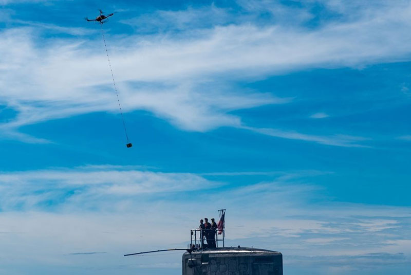
Package delivery to USS Hawaii (Photo: U.S. Navy/Mass Communication Specialist 1st Class Michael B. Zingaro)
Submarine delivery. The University of Hawaii and the U.S. Navy recently tested out a new way to supply an operational nuclear sub with a few essential items while the Virginia-class fast-attack submarine USS Hawaii was off the West coast of Oahu. A five-pound package of circuit cards, medical supplies and food too – which someone surely must have snuck in — was delivered using a Skyfront Perimeter gas-powered hybrid drone. The UAV has five-hour endurance, easily flying just one mile out to sea and back to complete the test delivery on Oct 10.
The package was lowered on a cable from the Perimeter drone and captured by a ‘snag’ pole extended off the sail of the submarine. This timely small package delivery to an underway sub has apparently led to the creation of the submarine force’s first UAV squadron in the Pacific, according to the Navy.
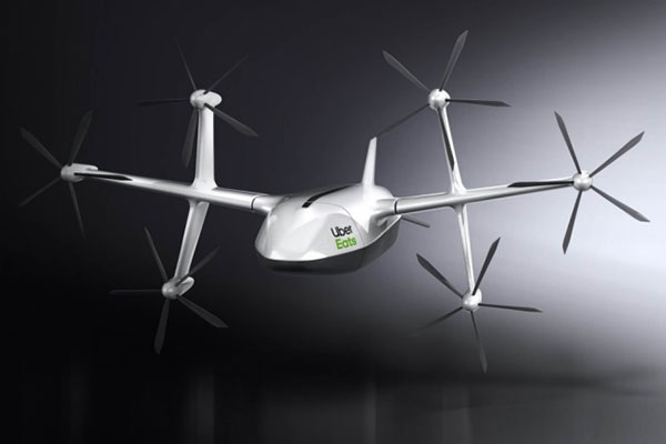
Uber Eats. Uber Eats has been testing food deliveries from McDonald’s near San Diego State University, and has just announced a new 6-rotor vertical take-off delivery drone it plans to use for more test deliveries next year in San Diego.
Uber Elevate delivery drone (Photo: Uber)
The ideal delivery profile for this drone is a meal for two picked up from a restaurant six miles away from dispatch in eight minutes, another six miles to make the delivery and then six miles to return to base — maybe less than 20-30 minutes all told. However, they have an intermediate drop-off to a ground-based delivery driver who then travels to the customer’s door to actually deliver the food. This process contrasts with Amazon’s approach — they are planning to lower packages on a cable directly to the customer – but food delivery might actually need a guy in a truck knocking on your door with hot food.
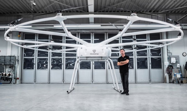
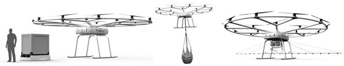
Heavy-lift drone. The Heavy-Lift VoloDrone, manufactured by Volocopter in Germany, flew for the first time in October. Targeted at the logistics sector, its anticipated that the large UAV may also find applications in agriculture, and other operations where a large – up to 440 pounds – payload is required. Velocopter has so far focused on unmanned air-taxi transports, but the larger scale involved in people transport appears to have spun off into a heavy-lift derivative UAV.
Christoph Hommet, chief engineer, with the heavy-lift VoloDrone. (Photo: Volocopter)
The VoloDrone is a powerful, fully electric, heavy-lift utility drone which is anticipated to have a range of up to 25 miles carrying a 440-pound payload. The rotor area has a diameter of 30 feet and the vehicle is 7.5 feet high. It can be remotely piloted or can fly autonomously on pre-set routes.
Loads can be carried between the legs of the landing gear on standard rack mounts or slung below, or a tank and sprayer could be fitted for agricultural applications. The 18 rotor multicopter platform uses swappable lithium-ion batteries and an in-house flight control system, and benefits from existing development and test of the air-taxi Velocopter.
Anywhere ground transportation or construction operations are challenged by difficult access, the VoloDrone might assist by providing an airborne option. It is designed as a universal air-lift vehicle which may be adapted to different use cases by the addition of special-purpose accessories.
Examples of VoloDrone load configurations. (Photo: Volocopter)
DJI drones barred. The U.S .Interior Dept. (DoI) has barred the use of DJI dones, except for emergency purposes. With a combined department fleet of over 800 drones, around 15% are supplied by Chinese manufacturer DJI.
Amid the on-going trade war between China and the U.S., members of Congress have grown increasingly concerned about American use of Chinese technology – whether DJI drones, or Huawei networking equipment. Recently Congress has proposed the American Drone Security Act to limit Government agencies’ use of Chinese equipment.
In anticipation of this issue DoI has already been working with DJI for over 15 months to identify possible security gaps in drone design, and DJI has come up with a “Government Edition” software load which ensures data is only gathered and stored on-board the drone and is isolated and downloaded for only DoI use after each flight — data transmission has been eliminated as a possible source of data leakage. DJI even volunteered to partial manufacture in the US. Therefore, DoI had previously resisted Congressional pressure to discontinue use of its fleet of DJI drones.
Nevertheless, DoI Secretary Bernhardt has ordered that Chinese drone use be now discontinued until an internal review is completed. In the meantime, DJI drones may only be operated by DoI for emergency purposes, “such as fighting wildfires, search and rescue, and dealing with natural disasters that may threaten life or property.”
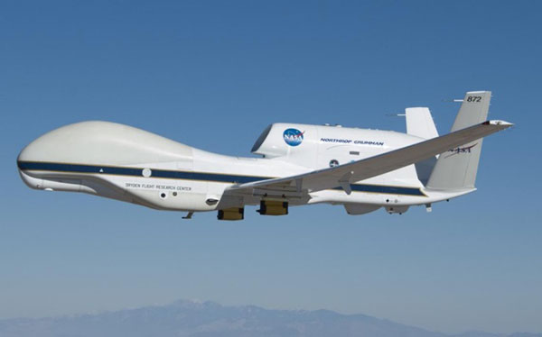
NASA Global Hawk UAV (Photo: NASA/Tom Miller)
Large BVLOS drones. The Grand Sky Beyond Visual Line of Sight (BVLOS) facility in North Dakota has become an operational base for large UAVs, including the General Atomics’ Predator and Northrup Grumman’s (NG) Global Hawk. The Grand Sky facility is immediately adjacent to Grand Forks Air Force Base, where the RQ-4 Global Hawk high altitude, long endurance autonomous aircraft is based.
In order to offer full operational capability to its intended customer base at Grand Sky, Northrup Grumman is building a hangar and has also established a Transportable Operations Center (TOC) in its Grand Sky Mission Control Center. It was through this TOC on October 10th that NG was able to take control of an in flight Global Hawk mission in California.
A NASA crew in California had managed the take off and flight of their Global Hawk from the NASA Armstrong Flight Research Center (AFRC) on Oct. 10, 2019. During the mission, the flight team at Grand Sky took over control of the aircraft and executed a series of flight maneuvers to demonstrate the operational capability of the TOC. This capability is key for the Grand Sky facility to become fully operational.
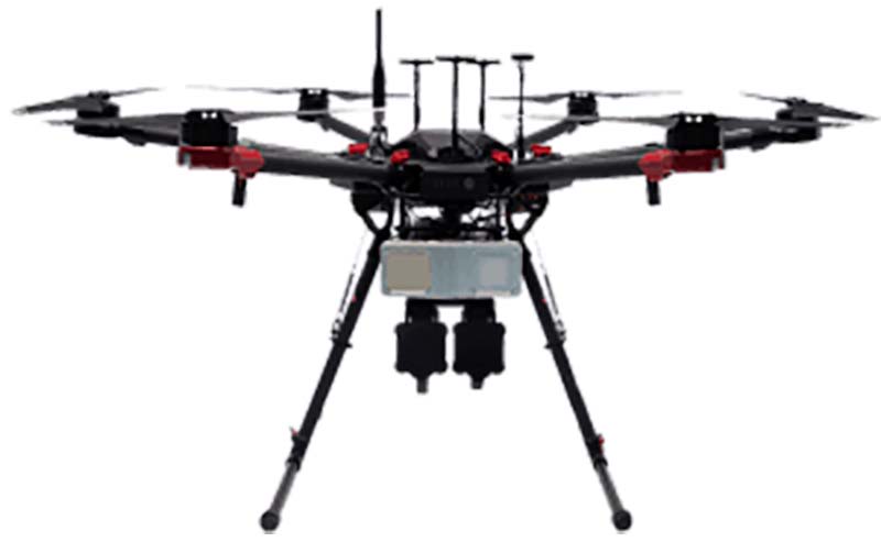
A Microdrone md4-1000 used in the surveys at EIA. (credit: EIA)
Runway inspection. Drones are never allowed to operate anywhere near an active airport, so it’s something of a switch to learn that the Edmonton International Airport (EIA) in Alberta, Canada , OK with operating a drone within the confines of the airport. Fortunately it’s a case of improving the safe operation and maintenance of the extensive runway infrastructure at the airport.
EIA has two million square feet of runways, taxiways and aircraft handling aprons which are all subject to wear by aircraft and suffer from the harsh weather extremes which are common in Canada. Therefore regular maintenance inspections are mandatory. Undertaking inspections manually in the past could take days to perform, so EIA adopted the use of drones to complete inspections much quicker and with higher accuracy.
The Microdrone md4-1000 drone is flown by Canadian company AERIUM to collect Lidar (Light Detection and Ranging) data and photographic/video imagery of EIA’s runways. The data collected is used to more accurately predict when to conduct preventative maintenance on ground infrastructure used by aircraft. Drone operations were approved by Edmonton Airport in collaboration with Nav Canada and AERIUM. EIA has previously flown a drone to minimize the number of birds on the airport during aircraft movements and in the process conducted the first-ever drone night flight at the airport.
A X-37B lands at the Kennedy Space Center. (Photo: USAF)
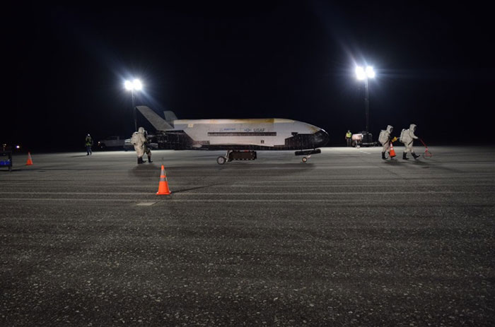
X-37B orbital vehicle. Finally, the daddy-of-all applications for remotely piloted vehicles became more apparent on Oct. 27, at 3:51 in the morning when the U.S. Air Force’s X-37B Orbital Test Vehicle successfully landed at NASA’s Kennedy Space Center Shuttle Landing Facility after 780 days on orbit.
The fifth mission was launched on Sept. 7, 2017 from Cape Canaveral Air Force Station, Florida by a SpaceX Falcon 9 booster. Looking like a miniature version of one of the retired Space Shuttle fleet, the X-37B is managed by the Air Force Rapid Capabilities Office, and ‘performs risk reduction, experimentation and concept of operations development for reusable space vehicle technologies.’ Long endurance stuff – the previous flight lasted 718 days. “This mission successfully hosted Air Force Research Laboratory experiments, among others, as well as providing a ride for small satellites,” said an Air Force spokesman.
The X37B provides a unique capability to test new systems in space and return them to Earth and enables the U.S. to more efficiently, effectively and rapidly develop evolving space capabilities. The U.S. Air Force is preparing to launch the sixth X-37B mission in 2020.
Final thoughts. As drones chug steadily along the path towards a rapid airborne delivery system, urgent deliveries to both submarines and hungry people ordering food are making progress. Heavy-Lift capability is evolving out of air-taxi research. The effects of trade wars and security concerns are touching established drone operations. We can now control huge aircraft remotely from almost anywhere. Runway inspection is being automated just like any other drone inspection/surveillance mission, and remote space operations are now regular practice.
It’s an expanding world of applications for drones, with many more different and perhaps unanticipated ones yet to come.
From growing crops to making movies, unmanned aerial vehicles (UAVs) are changing the way we work. UAVs — managed by unmanned aerial systems, or UAS — range from small indoor inspection units to giant Predator drones. They are streamlining how we manage mines and plants, deliver packages, and keep people safe. Read on to find out the latest in this skyrocketing market.
The unmanned aerial system (UAS) industry is in great shape! In the United States., the Federal Aviation Administration (FAA) appears to be helping commercial operations get off the ground, at least for those wishing to fly small unmanned aerial vehicles (UAVs).
Things are certainly hopping for unmanned aircraft in agriculture, mining and construction, facility inspection, newsgathering, movies and promotion. Package delivery is on the way, and, of course, defense is cooking with new innovations. Everywhere you look, a specialized drone or new application seems to appear that has good prospects for success.
One helpful aspect of today’s landscape for UAS operators in the U.S. is the FAA’s supportive approach to small UAS (sUAS) for commercial activities. After providing a regulatory framework with Part 107 rules, albeit with quite a few caveats that require a written waiver application, qualified drone operators are now able to fly their drones in many places — as long as they are below 400 feet, well away from airports, and nowhere near any restricted airspace.
Pilot qualification courses and proficiency testing are both readily available — at 676 commercial facilities across the U.S. according to the FAA website — and a successful online application process should result in a remote pilot’s certificate.
With a drone registered with the FAA, you can use the FAA’s B4UFLY mobile app to check if it’s safe to operate where you intend to. If it is, you can get approval in real time using the FAA’s Low Altitude Authorization and Notification Capability (LAANC) system. The FAA qualified LAANC to clear commercial drone operations, and the service is now provided by a large number of independent UAS service providers.
With the regulatory and approval path in place, it’s now possible for companies and individuals to earn a living with turn-key drone operations, providing services for many applications that have blossomed. There’s work to do beforehand, but it’s less arduous than for manned flight operations.
Let’s look at a few of the applications benefiting from the automation, enhancement and remote operations provided by UAVs as well as their on-board sensor suites and after-flight processing:
agriculture
mining and construction
facility inspection
newsgathering, movies and promotion
package delivery
defense
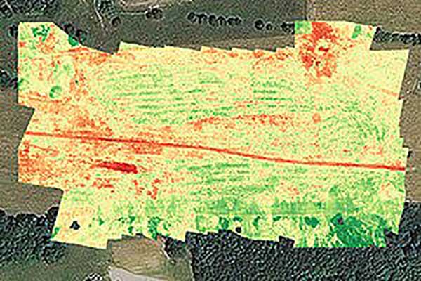
Crop health analysis: Precisionhawk’s software PrecisionAnalytics—Agriculture automatically generates georeferenced orthomosaics from data collected with drone sensors. (Map: PrecisionHawk)
Agriculture
Agriculture has readily adopted UAVs to monitor, control and improve overall crop growth rates — a part of what is known as precision agriculture. Drones carrying optical, thermal and laser scanning payloads gather stacks of information about the condition and rates of growth in fields. The information is then fed into various analysis tools. A picture emerges over time that indicates the health of crops. This enables farmers to generate a formulas for the nutrient and weed-reduction chemicals used for spraying at various times of the year. It’s a customized “prescription” for each growing area.
Continuing UAV overflights during the growing cycle monitor the effects of growing conditions and the effectiveness of treatments, providing more feedback that lead to even further improvements.
Smaller tech-savvy farms might run their own programs, supported by local agrochemical suppliers that may provide analysis services or sell analysis tools.
However, there has been a real growth in the number of companies that supply an entire turn-key package — supplying and flying drones, gathering data, running analyses and providing written and graphic output to support the farming operation.
Unmanned aircraft are truly an integral part of this approach, which might only have been possible because of semi-autonomous UAS and the evolution of compact sensors: UAV-mounted infrared, high-precision optical and lidar.
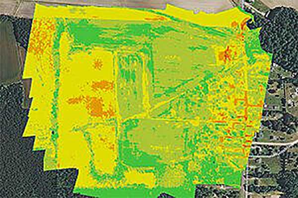
A sample prescription map. (Map: PrecisionHawk)
Mining and Construction
Any mine site is a busy — even chaotic — place to conduct a commercial business.
Drones provide a way for mining operations to:
quickly collect information to enable volume calculations;
provide relatively inexpensive site surveys; and
manage traffic and set up daily road layouts.
In effect, drones enable more rapid control of a complex and dynamic undertaking. Additionally, they improve safety. Ground surveyors no longer need to dodge huge operating machines and tumbling ore, or scramble around difficult terrain.
An autonomous drone can gather timely, georeferenced imagery that can be turned into a precise 3D model of the site. Site managers can have immediate access to details of the UAV survey. They can see the extent of existing deposits and know where to support further mineral exploration, receive estimates of stockpiles and tailing volumes, ensure that personnel and equipment are in the correct locations, and compare aerial video and photography day by day to check progress and for record-keeping. Drones can carry a wide variety of imaging and sensor packages including visual, infrared, hyperspectral, lidar, sonar and radar.
It’s also quicker. For instance, using the senseFly eBee fixed-wing drone, a full aerial survey of an 88-hectare site took four to five hours, with about half of that time spent placing control points. To achieve the same level of detail, terrestrial surveying would take a single surveyor two to three weeks.
Construction Operations. The construction sector uses the same drone data-capture techniques for site details, off-line analysis and results tabulation to manage operations of complex work sites. Compared to mining, change can be more intensive during a construction project, so drone surveys might be repeated more often.
Surveying and GIS. Using drones is an industry unto itself, with high-precision RTK GNSS in the air and on the ground, and specialized analysis tools for high-accuracy applications. The speed of data gathering is the principal benefit to an industry that continues to be essential in many sectors. Lower precision GIS for asset tracking and the like could become a subset of the applications and tools already discussed.
Facility inspection. Outdoor and indoor facility inspection is definitely benefiting from the automation that suitably equipped drones and customized analysis tools can bring to both regular and infrequent inspection tasks. The number of regular complex refinery inspections can be significantly reduced. Inspections will no longer interfere with production and will improve safety for inspection staff. For instance, flame stacks that burn off excess gases can be prone to failure, so regular inspection is essential. Using a drone for the task is clearly much safer than using personnel.
An offshore oil and gas construction platform vents gases to relieve pressure. Flame stacks such as these require regular inspection. (Photo: Oil and Gas Photographer/Shutterstock.com)
BVLOS for Pipelines and Rail
Automated pipeline and railway track inspection have both become possible as drones are used over much greater distances, thanks to beyond visual line of sight (BVLOS) operational approvals by the FAA.
For BVLOS, users first need a validated sense-and-avoid technology on the drone. Also required is proven radio telemetry with uninterrupted command-and-control of the vehicle during flight, and an independent ground-monitoring system that confirms how the drone maneuvers throughout the flight.
In the case of a BVLOS flight this summer along the Trans-Alaska oil pipeline, a Perimeter UAV manufactured by Skyfront flew about 4 miles, maintaining a constant above-ground altitude of 400 feet with multiple ascents and descents of 1,000 feet on 45-degree slopes. The long-range hybrid multicopter drone was equipped with Iris Automation’s computer vision collision-avoidance system and was monitored by
Launching a UAV for a BVLOS flight are (at left) Travis Balthazor, UAS flight operations manager, and Mike Kuni, UAS flight instructor/pilot, both of Kansas State University Polytechnic Campus. (Photo: KDOT, Division of Aviation)
Echodyne radars along the pipeline path, providing airspace situational awareness.
Another BVLOS operation built on the achievements of the Trans-Alaska pipeline trial has been authorized to fly a nine-mile linear inspection of power lines in rural Kansas.
Once again, the Iris Automation system will provide collision avoidance, but this drone also has an independent automated avoidance capability. This gives the drone the self-contained ability to fly around obstacles, so no ground radar or visual tracking is required.
Relieving the requirement for radar tracking or visual observers makes many new operations affordable. Previously, FAA Part 107 BVLOS waivers have all required visual observers or ground-based radar tracking — requirements that are not only expensive, but also restrict where flights are possible.
BVLOS operations like these demonstrate the cost-effectiveness of the technical solution, making long-duration, long-distance inspection using drones feasible.
Indoor inspection is becoming possible with specialized drones that circumvent the need to expose inspection staff to especially difficult facility environments, which in the past also required production shut-down to protect them. Thermal and visual sensors on swivel mounts enable protected inspection drones to fly into tight spaces — or even back out of tricky situations — and make visual records that may otherwise be virtually impossible.
Searching and recording inside containment vessels at the failed Fukushima nuclear facility may have been significantly advanced by using inspection drones.
Newsgathering, Movies and Promotion
All those panoramic, overhead, moving shots you see on the news, in movies and in ads used to be taken from a manned helicopter or fixed-wing aircraft. Now they are mostly taken by multi-copter drones with high-resolution cameras. This makes cinematography and newsgathering much more affordable, making these fields accessible by smaller operations. In the past, only large media groups could afford to rent a helicopter. And, of course, it’s much quicker to bring a UAV onto an incident site, operated by a crew on the ground.
You’ll need FAA approval to use a drone for commercial newsgathering purposes, or find a suitable qualified UAV and operator. After gaining FAA qualifications, news people are also taking on the job, buying and flying the equipment and managing the video-processing software themselves.
Others using drones for similar purposes are movie makers, producers of TV commercials and real estate agents, to name a few.
Delivery by Drone
The ultimate objective of many internet suppliers is to deliver goods that were just ordered within minutes of the order being placed. This is a pretty big objective. It requires a whole network of “fulfillment centers” in and around many cities, a massive purchasing and goods movement capability to keep these centers stocked, and a system that delivers to the end-customer. Currently, we mostly have manned panel trucks of various flavors handling that last step of the delivery process, with real people reading the notes we put on the porch about where to leave our package if we’re out.
Order and Receive. The next wave of delivery changes are expected to include drones carrying your package from the fulfillment center to your backyard. Amazon is looking for approval to begin trials with its larger 88-pound MK-27 Prime Air delivery drone, initially in sparsely populated areas. The MK-27 is equipped with intelligent sense-and-avoid capability, flying around any obstacles it encounters in flight and even during delivery.
UPS is also hoping to get to qualification of its own UAS delivery system by the end of this year, to the same standards that manned aircraft delivery systems are certificated.
Medical Deliveries. Many other trials are underway, especially involving medical deliveries and support. In Africa, trials are underway in Ghana, Malawi and Rwanda. UPS recently proposed a medical supplies delivery service using drones in North Carolina. Many companies that claim expertise in medical deliveries are operating drones.
Food on the Fly. Restaurant food delivery services have seen an upsurge in popularity. It seems likely that soon you’ll be able to order and receive lunch really quickly by drone food delivery services. Ground robot food deliveries at George Mason University are already a huge hit! Uber-Eats is experimenting with drone food deliveries, and 17 drone delivery routes have already been approved in an industrial park in Shanghai.
Meanwhile, Bell has flown its autonomous pod transport (APT) 70 near its base in Fort Worth, Texas, for the first time. The APT 70 can carry a 70-pound package load at over 100 mph, far faster and farther than existing drone delivery systems.
Bell is aiming for package delivery and critical medical transport for disaster relief for APT type drones. It is also participating in the NASA SOI program along with General Atomics’ SkyGuardian.
Drones are a new tool. The UAS industry will continue to change and adapt these products and this technology in as-yet-unthought-of ways. It’s an exciting time, and right now, there seems to be no end in sight.
For a look at drones in the defense industry, see Murfin’s article “Defense in front of UAV development,” published in September’s Professional OEM + UAV newsletter.
Drones continue to move further into everyday life and activity as they become more involved in applications that touch almost everyone. Previously a curious novelty, now unmanned aircraft are almost commonplace.
Real Estate. Suppose you are buying a new house. Almost all the exterior home pictures and video on real-estate websites come from dones. The high-definition photo capability of any commercially available drone is well up to providing great panoramic aerial shots — now virtually required to market homes.
Suitable UAVs and their operators are either readily available, or real-estate agents are taking on the job, buying and flying the equipment and managing the video-processing software themselves. Approvals for regular real-estate operations using drones now can be more readily obtained The objective is near real-time approval using the U.S. FAA’s Low Altitude Authorization and Notification Capability (LAANC) system, with drone operations provided by an expanding list of independent UAS Service Supplier companies, cleared and qualified by the FAA to provide commercial drone operations.
Crop Monitoring. In agriculture, it is virtually expected that a large farm operation will be on a crop monitoring/maintenance program that entails regular drone data-collection flights and automated processing of geo-tagged photographic, thermal and laser crop images. An initial baseline set of images establishes the starting point for the program, and then analysis identifies crop weaknesses. A fertilizer/treatment “prescription” is then drawn up to address deficiencies. After applications throughout the growing areas, follow-up drone monitoring checks whether growth rates have improved or if more remedial action is necessary.
The cycle continues throughout the growing season. A number of large and small companies offer turnkey services to farmers, or farms themselves run subsets of this UAS-based operation.
Construction and Inspection. Mining and construction now also have drone services that gather and process image data to automate significant parts of the process, as does surveying and geospatial information services (GIS).
Facility inspection using drones follows the agriculture model, with initial overflights establishing a baseline status record against which subsequent image data is compared.
Indoor automation with drones also has enabled a huge reduction in time spent in frequent physical inspection of tanks, pressure vessels, holds and more. It also has greatly improved safety for inspection personnel who no longer have to crawl through extensive, potentially toxic environments, such as the containment vessels at Fukushima Daiichi.
News and Events. News gathering has been enhanced by the use of drones. Aerial videos capture the news quickly and inexpensively compared to helicopters, and provide overview situational awareness for the news audience. In the same vein, we can add crowd surveillance at large events, where higher levels of security are required, such as the 2019 FIFA Women’s World Cup in Paris.
Chart: GPS World
Package Delivery. One classic drone application — package delivery — still hasn’t arrived fully, but many trials have been underway for several years, particularly for the delivery of medical supplies. It seems now that UPS is making a significant effort to qualify a UAS system that meets existing manned delivery standards (FAA Part 137 operations) by the end of this year. Wish them luck: there are many elements to prove and demonstrate for an unmanned delivery system, particularly in populated areas.
Security and Defense. Extensive use of drones in local and national policing and security operations has become almost commonplace, too. Cost-effective and easy-to-fly UAV systems have begun to replace manned surveillance helicopters, with police forces discovering significant improvements in reaction speed and affordability.
And, of course, the use of drones by defense forces worldwide has expanded greatly. Most people can picture the familiar silhouette of the General Atomics Reaper as their image of what a military drone looks like. Many people might even now know where the Straight of Hormuz is located, following the world-wide reports of an apparent Iranian attack that brought down a Northrop Grumman RQ-4 Global Hawk, followed by the takedown of one or two Iranian drones by the USS Boxer in the same area. Drones would now seem to be predominantly associated by Joe Public with a level of military aerial presence — perhaps more so than in any civilian applications.
New and different configurations of UAS continue to rapidly emerge for any and all applications in both the civil and military sectors. Now that we have operating regulations for small UAS in the U.S. and elsewhere around the world, cost-effective commercial uses abound and support new and existing tasks, and the military is rapidly creating new variations to assist or replace manned ground, navy and airborne forces. Large and small investments in artificial Intelligence for drone automation seem to be announced almost daily – so we can expect some independent drone capability to emerge over time.
There is only much, much more to come.
TONY MURFIN is a GNSS aerospace consultant with several decades experience at leading companies in the GPS/aviation and OEM sectors.
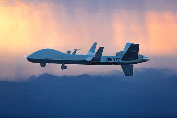
The MQ-9B SkyGuardian will participate in NASA-sponsored flight tests in 2020. (Photo: General Atomics Aeronautical Systems)
The defense segment is going from strength to strength — despite a phase not too long ago when defense spending appeared to be dropping. Widespread drone use received a boost with specialized equipment developed for defense forces applications.
The Predator Advances
The General Atomics Predator has gone from a long-distance loiter-and-observe UAV to frontline precision-strike capability, and has been adopted by many military forces around the world.
From first flights in 1994 to initial production in 1997, the Predator has now evolved into many configurations equipped with piston engine, turboprop and jet; line-of-sight radio and satellite command and control; synthetic aperture radar and multi-spectral targeting system; video, TV and thermographic cameras; and laser designators and other payloads.
From pure reconnaissance to various strike and attack configurations, the names have also changed. Predator, Reaper, Gray Eagle, Avenger, Protector, Guardian and SkyGuardian have a host of RQ/MQ designations. For instance, In the RQ-4 Global Hawk name, the “R” means reconnaissance, the “Q” means unmanned aircraft, and the “4” is the series.
The SkyGuardian version of the Predator is a certifiable variant anticipated to ultimately become fully authorized for controlled airspace. It will take part in the NASA Systems Integration and Operationalization (SOI) demonstration program in mid-2020, which will highlight commercial UAS missions using larger drones in the national airspace.
The Predator family has now been evolving for more than 25 years. Unfortunately, the popularity of the Predator family of military unmanned aircraft has led to recent headline news about Predators shot down in the Gulf of Hormuz, or crashed in Afghanistan — such is the price of success!
Global Hawk Gathers Intel
The Northrop Grumman Global Hawk has become a U.S. mainline, high-altitude intelligence gathering asset, deployed by both the U.S. Air Force (RQ-4 Global Hawk) and Navy (MQ-4C Triton). Other friendly nations have also shown various levels of interest in acquiring variants, including Germany, Australia, Canada, Japan and South Korea.
Northrop Grumman has reintroduced the Firebird as a contender in the airborne intelligence, surveillance and reconnaissance (ISR) field. The Firebird can be configured as unmanned (ground control), autonomous or piloted, and has payload flexibility through open architecture, plug-and-play integration.
The North Dakota UAS test range facility at Grand Sky has initiated procurement of two Firebird UAVs, which they intend to supply to their customers for mapping, inspection and monitoring applications using their extensive, long-range BVLOS capabilities.
Skyborg Equipped with AI
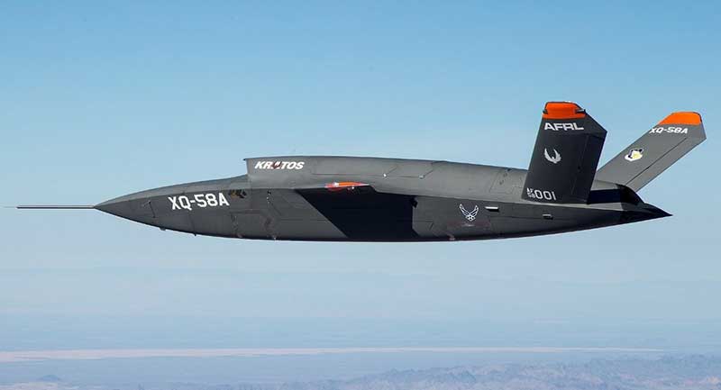
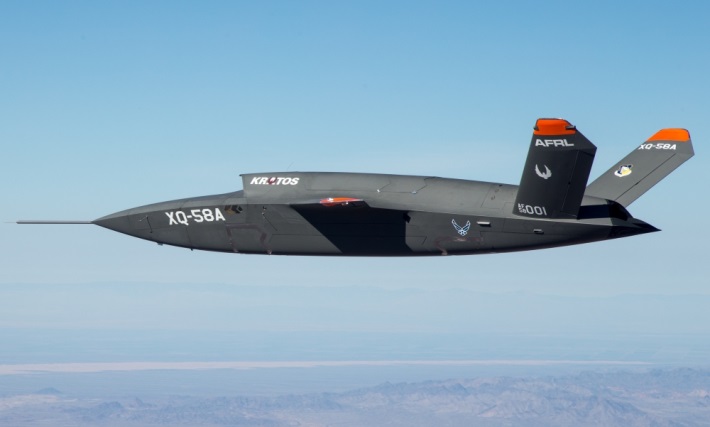
And then there’s this U.S. Air Force Skyborg program, which aims to drag the most possible out of artificial intelligence (AI) and automation in an airborne fighter support roll. Kratos has flown the drone hardware a couple of times – the XQ-58A Valkyrie is a “low-cost” unmanned aircraft designed to fly alongside front-line attack aircraft like the F-35 and F-18.
The Air Force Research Laboratory (AFRL) is researching the technology, new sensors, payloads and networking capability these drones will be outfitted with to fly alongside manned fighter jets.
A whole slew of other extremely capable drones are already being operated by the U.S. Army and Navy in a variety of support roles.
Anti-Drone Detection and Prevention
On the flip side, an entirely new related industry segment has come about in the last several years, usually adapting existing radar, sound, infrared or other ground detection systems.
This segment is aimed at circumventing unwelcome drone encroachment over sensitive facilities. Airports, governments, prisons, and energy and water utilities are among the facilities who want to prevent unwanted drones penetrating their airspace.
Solutions may be portable and short range, or ground-based and longer range, with the capability to take down an invading drone or detect where it came from and provide significant warning time.
One solution uses an attack drone that ensnares an intruder-drone in a net and brings it the defender’s location to support second-level investigations. Whatever the solution, drone defense is a growing field.
Some ups and downs for unmanned aircraft this month — good news that there is further progress on the pseudo-satellite front, but we also have MIL-SPEC drones lost to shoot-downs and recent crash landings. Amazon continues to advance toward deliveries really soon after orders, and another police department takes up drone use for aerial observation.
High-Altitude Pseudo-Satellite UAS
HAPSMobile (Softbank 95% and AeroVironment 5% JV) is funding further development and testing of the Hawk30 family of high-altitude pseudo-satellite (HAPS) solar-powered unmanned aircraft, with the expectation of long-duration flights above 65,000 feet — “a super cell-tower up in the stratosphere…providing connectivity for everybody that needs it,” according to AeroVironment President and CEO Wahid Nawabi.
HAPSMobile is collaborating with the Pan-Pacific UAS Test Range Complex (PPUTRC), which is managed by the University of Alaska (UA) Fairbanks, and with the University of Hawaii (UH) to conduct stratospheric test flights using the HAWK30 prototype HAPS vehicle. On behalf of this group, UA was recently granted a Certificate of Authorization by the U.S. Federal Aviation Administration (FAA) to fly HAWK30 as a stratospheric telecommunications platform system over the Hawaiian island of Lanai.
The HAPSMobile team will prep test flights at Lanai during 2019, conducting safety verifications and working with island authorities to comply with local regulations. During the program, HAPSMobile will also explore contributions to environmental conservation and to agriculture. Hawaii — not a bad place to run test flights, you might say…
Predator UAV downed
Following the shooting down of a U.S. Global Hawk (really expensive) and one or two Iranian drones (not very expensive) in the Gulf of Hormuz, U.S. forces on Aug. 13 just crash-landed an MQ-1C Grey Eagle (Predator UAV family) southwest of Baghdad on farmland in the town of Radwaniyah. The following pictures were released by a local news group:
The aircraft doesn’t appear to be too badly damaged, and seems to have been deliberately brought to rest in soft undergrowth on the edge of a field. So crash-landing might be an overstatement — rather an unplanned landing, perhaps? Then again, the landing gear appears to be significantly bent out of shape, so the U.S. Army 52178 drone’s contact with the ground might have been heavier than normal.
The news source indicated that the drone might have been brought down by “electronic interference or have been intercepted by a cyber-attack.” perhaps references to potential jamming of some kind? Nevertheless, the aircraft landed safely and was then recovered by Iraqi Security Forces. There were no injuries or damage to property.
The U.S. Army MQ-1C Gray Eagle provides both combat and intelligence forces with a long-endurance, armed, unmanned aircraft system (UAS) with significant range, altitude and payload flexibility.
And another report hit the internet today that back in June, a £6 million U.K. Watchkeeper WK050 drone on a training flight met a somewhat messy end after overshooting its landing and coming to rest in a tree. But the report also mentions that there was some indication of possible operator error.
Amazon Drone Deliveries?
Fresh on the heels of Fed Ex deciding to dump Amazon as a customer because they would appear to be developing a competing delivery infrastructure, Amazon is proposing a semi-autonomous drone that could automate short-distance deliveries.
In a recent letter to the FAA, Amazon is proposing trials in “sparsely populated” regions of the U.S. using its latest 88lb MK-27 Prime Air delivery drone. The UAV apparently has well-developed sense-and-avoid for the flight phase and uses optical capability for the delivery phase.
If obstacles were to be detected in flight (other UAVs, low-flying manned aircraft, helicopters or birds) the MK-27 would avoid and fly round each obstacle. If an obstacle were detected during delivery (maybe the customer waving frantically to stay out of the cabbage patch) the delivery may be aborted and the drone would return to base. But would it automatically dispense one of those “We-called-while-you-were-out” postcards, fluttering down into the backyard so you could go pick up your package later?
Seriously, though… The initial trials would be managed by an operator who can command a return to base if the drone gets into any trouble, but Amazon claims that the fail-safe autonomy built into the MK-27 will make this unlikely. The hardware and software have gone through extensive simulated testing, and the drone has already completed more than 10,000 simulated delivery flights into representative backyards.
Amazon’s objective seems to be to eventually deliver packages within 30 minutes after the customer places an order — to Prime customers within ~8.5 miles from an Amazon fulfillment center.
Growing Police Use of Drones
The Oneida County, New York, Sheriff’s Office just announced that it is are now drone-trained and drone-equipped — with five certificated operators and a fleet of eight DJI Mavic drones for indoor and outdoor use.
The DJI drones will not be modified and will be used as is. The Mavic 2 drones will provide all manner of aerial surveillance including flood and disaster monitoring. In addition, active shooter investigations and the like could involve initial indoor surveillance using Mavic Air drone(s) to provide armed police with situational awareness before any take-down efforts. Accident investigations, location of missing persons, house fires, and rescue efforts are other applications for the drones.
The Sherriff’s department has been preparing for drone use for two years — five officers have already completed FAA-certified drone training, and others are expected to undertake training over time.
Summary
We have potential stratospheric “cell towers” being tested over Hawaii, landing accidents, preparations for potential rapid deliveries by Amazon drones, and another police department launching a drone unit. These are some of the expanding uses for drones, and the unfortunate reality that drones can sometimes get into operational difficulties.
With tariffs, trade wars and sanctions ruling the day, how is a self-respecting UAS manufacturer supposed to make a buck? And to whom are the manufacturers of defense UAS able to sell their wares?
To NATO and other friendly countries, comes the ready answer, but there may still be a problem selling drones with armaments and offensive capabilities. Another layer of governmental review could swing into action when a company wants to sell to friendly countries like Saudi Arabia or perhaps to allies within the old Russian USSR block.
Last year, General Atomics lost sales to Saudi Arabia and the United Arab Emirates (UAE) for Predators and/or Reapers, large-bodied medium-altitude, long-endurance unmanned aircraft systems (or MALES). The deal went instead to a competing Chinese outfit. General Atomics complained bitterly about the loss of this business, which it blamed on restrictive U.S. export rules. The Administration responded by apparently loosening the regulations, in fact easing the way for most international sales. In response, it is possible that UAV manufacturers have also undertaken some changes which make U.S. drones even more competitive for export.
Business matters appear to have improved significantly. In May this year, the State Department actually used emergency provisions within the Arms Control Act to bypass Congressional review of a proposed sale to Saudi Arabia, UAE and Jordan of a package of Insitu Blackjack drones and launchers, worth $80 million.
The competition for world-wide sales of U.S. UAS products is increasingly tough, especially against Chinese suppliers with equivalent or perhaps less capable mil-spec drones. Hence the export rule changes which now appear to be working in the right direction.
Chinese Drones in the U.S.
Meanwhile, in an effort to accommodate U.S. concerns about the potential for user data somehow “leaking” to DJI — the Chinese supplier of almost 75% of U.S. drone purchases — DJI has implemented a “Government Edition” which apparently addresses the risk of data loss.
When US-based 3D Robotics stopped supplying 3DR Solo drones, the Interior Department found itself in a bind, as it had already bought hundreds of these devices for its inspection/surveillance operations. As the department searched for a new source for UAVs, it came to the conclusion that U.S. supplied drones were much less capable or up to ten times more expensive than equivalent DJI units. So they began working with DJI to solve the issue with potential data loss, and went on to test the results extensively
Working with the U.S. Interior Department for over 18 months, DJI has equipped drones and their controllers with modified hardware and custom software that ensure that the drones only operate in local data mode: information collected in flight is stored on the UAV alone and must be manually downloaded after flight. The drone is actually loaded with custom software by the user prior to flight to ensure this mode of data collection.
Even with these modifications, for now the use of DJI drones is still restricted to non-sensitive applications.
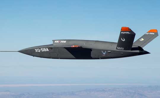
USAF/Kratos XQ-58A
The XQ-58A Valkyrie demonstrator, a long-range, high subsonic UAV completed its inaugural flight March 5, 2019, at Yuma Proving Grounds, Arizona. (Photo: U.S. Defense Department)
Kratos is working with the U.S. Air Force to develop a jet-powered UAV system that can fly alongside manned fighter aircraft to multiply their effectiveness. At much lower cost than manned aircraft, the concept appears to be that more risk can be taken with the ‘loyal wingman’ UAVs to not only support the mission of the attack aircraft, but to also keep it safe.
We reported earlier on the XQ-58A after its first flight in March of this year. Now the Valkyrie is back in the flight test program with its second flight lasting 71 minutes over the Yuma test range on June 11. In the long- erm, it is hoped that both ground controllers and flight crew would operate these extensively autonomous drones.
A parallel “Skyborg” program is also underway to develop the hardware and artificial intelligence software capability to enable this type of drone to fly and fight alongside manned aircraft.
In conclusion, trade wars and tariffs aside, let’s hope that good UAV products can still make headway on their merits alone.
Welcome to Part 2 of our coverage of the mammoth AUVSI Xponential 2019 show in Chicago, which drew 8,000 attendees, featured 300+ speakers on its technical program, and furnished a temporary home for more than 800 exhibitors. It was “Everything Unmanned” and a challenge to cover. Last month we looked primarily at new vehicles. This month’s column focuses on sensors, capabilities and apps aboard those and other airborne drones — and even an anti-drone drone!
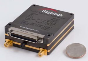
Sagetech: For UAVs to gain entry to the US National Airspace System (NAS) and to other controlled airspace all around the world, sense-and-avoid capability is paramount. Sagetech comes from the world of Mode-S transponders, with which the majority of piloted aircraft are equipped. These devices transmit aircraft identification and provide the moving IDs on air-traffic controller display monitors. In the military sector, Identification Friend or Foe (IFF) interrogator-transponders enable similarly equipped aircraft of NATO countries to determine which are friendly aircraft within their immediate airspace, and which are not.
The MX12B Mode 5 IFF with FAA-certified civil modes. (Photo: Sagetech)
Sagetech has just released a micro-mode 5 MX12B aviation transponder that enables small unmanned aircraft to interoperate within NATO airborne units. The transponders weigh around 10lb, so mil-spec UAVs operating in NATO airspace can now also carry this light-weight unit.
For civilian UAVs, GPS has been added to provide aircraft position outputs in Automatic Dependent Surveillance Broadcast (ADS–B) message format, allowing other aircraft and UAVs to receive a vehicle’s location. The Sagetech ADS-B transponder is small, certified to Federal Aviation Administration (FAA) standards (TSO C-166b) and is affordable. Boeing Scan-Eagle UAVs apparently already carry Sagetech transponder capability.
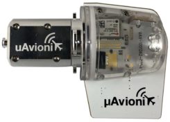
The tailBeacon ADS-B retrofit. (Photo: uAvionics)
uAvionix: Another avionics supplier has brought out certified ADS-B capable transponders, but with a novel way to add the required capability to general aviation (GA) aircraft, typically smaller private planes. The FAA has mandated that all aircraft should be fitted with ADS-B capability by January 1, 2020 in order to fly within controlled airspace, so uAvionix has simplified ADS-B retrofit for older GA aircraft.
All aircraft have wingtip and/or rear-tail beacon lights; this update replaces their existing beacon with a light which also includes ADS-B capability when paired with the aircraft transponder.
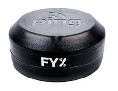
The FYXnav TSO CERTIFIED GPS navigation source. (Photo: uAvionics)
uAvionix also supplies a couple of GPS sensors for external mounting on UAVs: the FYXnav sensor is FAA-certified to TSO-C199 Traffic Awareness Beacon System Class B.
Sensefly released a new inspection application for their eBeeX UAV, specifically designed for solar farms. With a dual thermal/video sensor for data collection and data processing using application-specific Raptor Maps software, Sensefly claims to reduce the inspection time required for a 150MW solar farm to around 1 day, a 300-times improvement on ground inspection using a hand-held thermographic sensor.
Provided an inspection operation could support five 70-minute eBee-X flights during one day, the UAV could over-fly up to 161 acres of solar panels at an altitude of 138ft, gathering anomalies during each flight. This adds up to 150MW of solar panels over the 5 flights. Sensefly claims this to be twice as fast as with multi-rotor dones. The Raptor Maps software then generates an inspection report identifying each anomaly, using the eBee X’s video and thermal imagery to identify, classify, and localize the detected problems.
The Fortem DroneHunter intercept drone. (Photo: Fortem)
Fortem makes an anti-drone defense combining a radar detection system with a DroneHunter drone that attacks other UAVs, releasing an 80ft net to capture intruders. For those nefarious drones which are hardened against RF countermeasures, this system is also touted as capable of recovering the offending drone without damage, returning it to the operator in a net at the end of a tether. The DroneHunter flies autonomously on its intercept mission, carrying a compact radar system integrated with a ballistic net release system.
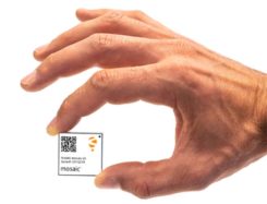
Septentrio continued promotion of its Mosaic chip-level GNSS at Xponential. The new chip uses the same proven core DSP with a new RF front-end and a new processor, working with more than 30 signals from the existing six GNSS constellations, and with L-band and satellite-based augmentation systems (SBAS).
The chip appears to be aimed at the high-precision market, replacing the AsteRx-m2 board level receiver family.
The chip runs Septentrio RTK algorithms, is quite small (1.29 x 1.29 x 0.15 in), is designed for high-volume surface mount manufacture, and comes with a set of popular interfaces. The chip is sampling now, with production planned for later this year.
NovAtel is growing, opening new offices in the US and needing more local real-estate to fit its headquarters in Calgary, Canada. The company is now part of Hexagon Positioning Intelligence (Hexagon PI), a partial re-branding that includes VERIPOS correction services and recently purchased AutonomousStuff, specializing in ground vehicles. Each organization still operates individually through its own brands. On the NovAtel booth, existing products were presented through a number of new applications, including those of the growing mil-spec products group.
Summary. While AUVSI Xponential was over in early May, the companies who were there have not rested. All are developing new approaches for UAVs and unmanned ground vehicles, sensor systems for even wider applications than seen in Chicago, and all manner of other added capabilities. This business only gets bigger and more innovative.
This year’s AUVSI Xponential show continued to demonstrate how large, thriving and visionary the UAV market is proving itself to be. With attendance around 8,000 people, an extensive technical program featuring more than 300 speakers, and a huge show floor displaying a wide range of sizes, configurations and applications, this was truly 2019’s place to be, see and — for the exhibitors — be seen.
On the large-format side,
an expanding test-range facility in North Dakota brings experimental capability to the oversize crowd,
Bell and Boeing are going full-tilt with large UAVs, both rotor and fixed-wing, and
a higher level market is emerging at 20 kilometers (12 miles, or 65,000 feet) above the Earth.
In the smaller-sized portion of the market, hydrogen fuel cells are extending operational time, and indoor inspections can be significantly cost- and time-reduced with new task-specific models.
Hurricane Irma response. Tuesday morning’s opening keynote featured an overview of how Florida Power and Light (FPL) and Precision Hawk undertook recovery inspections following Hurricane Irma in 2018.
This rang a bell for me, as Irma was the first hurricane I lived through; it passed 30–50 miles to the east of us, up the center of Florida.
FPL flew 4,000 miles with Precision Hawk drones, looking for downed and damaged transmission lines and blown transformers throughout its massive distribution network.
UAVs on the Show Floor
With roughly 800 exhibitors, it’s impossible to see everything, let alone talk with all the companies. So the following is a small subset from the show, with highlights from the large-format UAV sector and a few smaller ones. Further coverage of the show will appear in next month’s newsletter column.
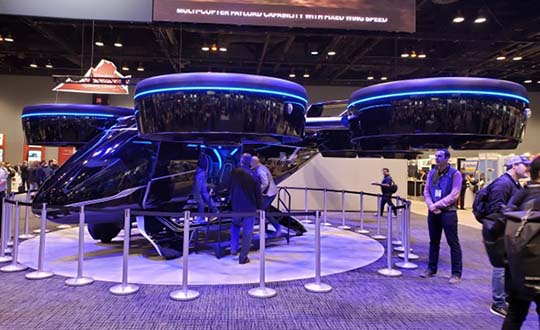
The Bell Nexus demonstrator drew crowds at AUVSI Xponential 2019. (Photo: Tony Murfin)
Bell Helicopter. The Bell Nexus demonstration tilt-rotor – judging solely by the number of smartphone picture takers – was the hit of the show.
Nexus is gleaming blue, with six 8-foot tilt-rotors. The booth had a massive display screen in the back running a loop of its exploits, along with what seemed to be animations of future adventures — flying people around city-center skyscrapers.
Tail-sitter package delivery drone. (Photo: Tony Murfin)
This brings up lots of potential failure modes to be mitigated (six rotors rather than one regular helicopter rotor blade and a complex control system, for instance) for the Federal Aviation Administration (FAA) to chew on during the certification process.
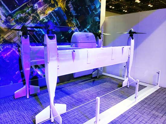
A large four-tail package-carrying sitter drone for larger item deliveries took second place at the Bell booth, even though it is possibly closer to becoming a reality than the gleaming blue star of the show.
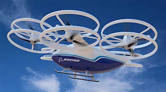
Boeing’s tilt-rotor UAV prototype recently flew its first test flight. (Photo: Boeing)
Boeing. Meanwhile, Boeing was apparently preparing to fly a prototype version of a tilt-rotor UAV, only Boeing’s is designed to be a heavy cargo lifter. The Cargo Air Vehicle prototype vehicle has six tilt-capable dual-rotor systems, weighs 1,100 pounds and is 17.5 x 20 x 5 feet tall. It’s interesting how similar the Bell and Boeing (production concept) configurations seem to be.
Boeing design concept for the Cargo Air Vehicle. (Image: Boeing)
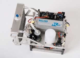
Ballard. Most multi-rotors on UAVs are driven by electric motors, so battery capacity determines the duration of flying time. Ballard has developed the FCair hydrogen fuel cell, which can extend flight time to up to 90 minutes, almost three times that of lithium-ion battery-powered drones.
FCair 600W hydrogen fuel cell. (Photo: Ballard)
Insitu, AeroVironment, Lockheed-Martin, and others have flown the Ballard fuel-cell system; apparently this list also includes the U.S. Naval Research Laboratory and the Air Force.
Grand Sky. The Grand Sky Aviation Park in North Dakota is co-located within the 217 acres Grand Forks Air Force Base (AFB) and has FAA approval as a UAV beyond-visual-line-of-sight (BVLOS) test range.
North Dakota has invested more than $34 million in UAV efforts within the state, with a good chunk going towards the infrastructure at Grand Sky. Now only UAVs fly out of the facility, with Northrop Grumman and General Atomics making it an operational base for Global Hawk, Reaper and Predator drones.
One of the principal benefits is the ability to fly BVLOS operations for large drones at Grand Sky. The system uses two long-range primary radars, one at Grand Forks AFB and the other in Hillsboro, that can detect non-cooperative aircraft.
Harris RangeVue radar and Harris ADS-B sensors coupled with the Air Force’s DASR-11 radar enable BVLOS testing without using a chase plane or staying within line-of-sight. This enables 10–12 hour missions within the 30-mile, 18,000-foot BVLOS range, with continuous electronic monitoring by the ground-based radar system.
A new operational center is being built to house the integrated system and to provide access for visiting drone operators, and the BVLOS range is expected to be ultimately extended all the way to the Canadian border.
Flyability. The Elios 2 UAS system has evolved to include a rotatable thermal and high-definition visual camera payload, 10,000-lumen oblique lighting system, and reversible rotors that enable the UAV to back out of tricky situations.
A geodesic-like cage surrounding the drone makes it collision-tolerant and enables flight in restricted indoor areas such as refinery enclosures, mines, vats, cargo holds and nuclear containment vessels — anywhere, in fact, that inspections today are regularly conducted by people.
A typical nuclear plant inspection might cost $500,000, while this drone system costs around $35,000, and an inspection might take around 10 minutes. For traditional inspections, plants might have to go offline completely while people crawl around in extremely difficult, often dangerous spaces, and manual reports might take significant time to produce.
Flyability claims huge savings in inspection time with their system, as well as automated analysis and production of reports.
AeroVironment. Just before the show, SoftBank, Japan and AeroVironment held a press conference in Japan outlining their HAPSMobile Joint Venture to address the lack of communications access in many parts of the world. Almost 3.7 billion people, or half the world’s population, currently do not have internet access.
SoftBank wants to provide internet inexpensively, without the need for extensive ground infrastructure, by operating high-altitude pseudo-satellite (HAPS) UAVs. HAPS is expected to fly in the stratosphere at a 20-kilometer height for up to six months, powered by solar cells and equipped with payloads that enable direct connection to the internet for users on the ground.
Airborne-type certification and spectrum will be required for the uplink/downlink. Both present significant challenges, but HAPS suppliers, including Airbus, Facebook and others are joining the fight for spectrum. AeroVironment has a $65 million contract from HAPSMobile to develop and produce HAPS UAVs, and build of their Hawk 30 HAPS UAV is well underway.
HAPSMobile has also taken a minority $125 million position with Loon, which has been flying stratospheric balloons for several years, providing wireless coverage in Puerto Rico after Hurricane Irma, and network coverage in South America.
Other suppliers exploring the HAPS market at the show included Airbus, which displayed its Zephyr UAV and recently announced the opening of the Wyndham HAPS launch site in Western Australia; and UAVOS, which announced a new control system for its HAPS vehicle.
In addition, Boeing’s unmanned aircraft subsidiary, Aurora Flight Sciences, has already made significant claims about the capabilities of its own Odysseus HAPS UAV program.
Recapping the Recap. With many more exhibitors and limited time, the rest of the story from Chicago’s 2019 Xponential exhibition will have to wait till next month, to include show news from Sagetech, uAvionics, Sensefly, Fortem, Septentrio, NovAtel and others.
In sum, we see a wide range of different applications all benefiting from unmanned air vehicles of different types and configurations. A number of outfits are working the HAPS gamble, North Dakota’s BVLOS test-range expansion brings experimental capability to the oversize crowd, and Bell and Boeing are going full-tilt with large UAVs, both rotor and fixed-wing.
These developments clearly indicate that the UAS business continues to grow into a huge number of applications and to look very healthy.
AUVSI Xponential 2019 — the huge exhibition and conference built around unmanned everything — will run at the West Building, McCormick Place Convention Center, April 29 to May 2 in Chicago.
This is the premier show for the Association for Unmanned Vehicle Systems International (AUVSI) group and its many members and supporters who have interest in unmanned technology — 8,500 attendees with connection to unmanned and autonomous capability are expected to walk the exhibit hall to see the latest products, hear numerous related presentations, participate in educational courses, and mingle with other like-minded people in the industry.
I was looking for a way to provide a brief overview of the companies exhibiting; a sample cross-section to provide an insight on what to expect. But with more than 700 exhibitors, it’s a difficult thing to do. Then I realized that the company show preview emails in my inbox were from organizations that were actually quite representative of the industry, and I had my overview selection.
Flyability’s drones are adapted for inspection tasks, both indoors and out, with an exterior protective cage. Routine inspection jobs indoors, underground and around complex pipework become quicker, safer and are fully documented by high-resolution video and stills.
This all enables the reduction of costs and process-interruption downtime of industrial inspections, while also reducing to a large degree the risks for inspection professionals. Industries using these inspection drones include power generation, oil and gas, chemicals, maritime, infrastructures and utilities, and public safety.
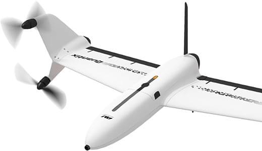
AeroVironment’s drones are used extensively by the military for surveillance and reconnaissance, and in the commercial sector they focus on tools for agriculture.
Quantix drone. (Photo: AeroVironment)
The VTOL (vertical take-off and landing) Quantix drone system is fully automated for takeoff, flight and landing, enabling mapping of farm acreage to monitor crop health to identify anomalies due to water, insect, weed and disease so their impact on yield can be minimized.
Valqari has developed a drone mailbox that is interoperable with a large number of delivery drones and enables drop-off of packages in residential neighborhoods.
The Valqari drone mailbox automatically accepts packages and safely stores them until the recipient opens the box later to retrieve them.
Cepton Technologies makes lidar systems more commonly used for automotive obstacle detection, but now customized for UAV integration and use. Its UAV lidar system provides long-range, high-resolution and low-cost mapping capabilities in a lightweight package. With a scanning range of 200 meters, high-density map-data acquisition becomes possible.
Deseret UAS is a non-profit working to bring UAS business to Utah — the organization offers information, promotes UAS companies and offers test-range access in Utah. In collaboration with Utah State University AggieAir, FAA authority for flight testing in wide open; low-risk operational areas of Utah can be accessed.
And, of course, General Atomics Aeronautical Systems (GA-ASI), manufacturer of the well-known Predator military drone, will exhibit. At Xponential 2018, GA-ASI unveiled its MQ-9B SkyGuardian certifiable drone system. Through the year, the company has progressed towards certification of the system for flight within the U.S. civilian National Airspace System and the civil airspace of other countries around the world.
GA-ASI’s latest media release recounted how an MQ-9B was flown by the company’s Certifiable Ground Control Station (CGCS) on March 9, including both take-off and landing. The CGCS architecture separates flight and mission-critical functions. Off-the-shelf avionics and flight computers are used for flight-critical functions, and mission-critical functions run alongside GA-ASI’s Advanced Cockpit payload and weapons equipment.
Meanwhile, High Altitude Pseudo-Satellite (HAPS) unmanned aircraft are back in the news with what appears to be a crash during the sensitive take-off/climb-out regime. The Airbus Zephyr aircraft — with an 82-foot wingspan, but weighing less than 75 pounds — was engaged in a test campaign in Western Australia when the ground abruptly intervened on March 15.
Airbus is working with the UK Ministry of Defence to demonstrate the operational capabilities of the UAV and its anticipated payload options. Once airborne, Zephyr is intended to climb out to upwards of 65,000 feet into the stratosphere — previously achieving a maximum altitude of 74,000 feet — and has so far been able to remain airborne for almost 26 days. The object is to create a commercial, reusable, reconfigurable satellite-like capability for communications and surveillance applications.
Airbus and MoD are undertaking a crash investigation to determine what exactly happened and how to prevent future recurrence. The incident occurred about four hours into a demonstration flight, and (reading between the lines) may have been related to rapid weather changes that destabilized the UAV while in the take-off and climb-out phase. An automated launch system is in the works — currently Zephyr is man-handled for take-off.
Other HAPS programs include AeroVironment and Japan’s Softbank, Astigan and the UK Ordnance Survey, BAE Systems and Prismatic, and Boeing’s Aurora Flight Sciences. Thales, meanwhile, is apparently focusing on an approach using an autonomous airship.
So some good news, some not so good. Lots of attendees are expected in Chicago for the AUVSI Xponential show, with new developments in unmanned aircraft, robotics, and unmanned ground and water systems anticipated in the exhibition hall. There will be lots of people in the industry with whom to exchange ideas and conduct business to conduct, hopefully just as spring arrives in the windy city.
Meanwhile, over the coming months Airbus will no doubt continue to work out how to overcome the latest problems in HAPS technology and operations.
Few commercial UAV operations would be able to inspect transmissions lines, pipelines or train tracks without beyond visual line-of-sight (BVLOS) capability, but these key pieces of infrastructure often situate close to or transit across population centers. Further, many population centers have airports and low-level air traffic. Any tools to keep drones away from air traffic during BVLOS operations will significantly inspection companies. We review three promising solutions here.
Pipeline Inspection
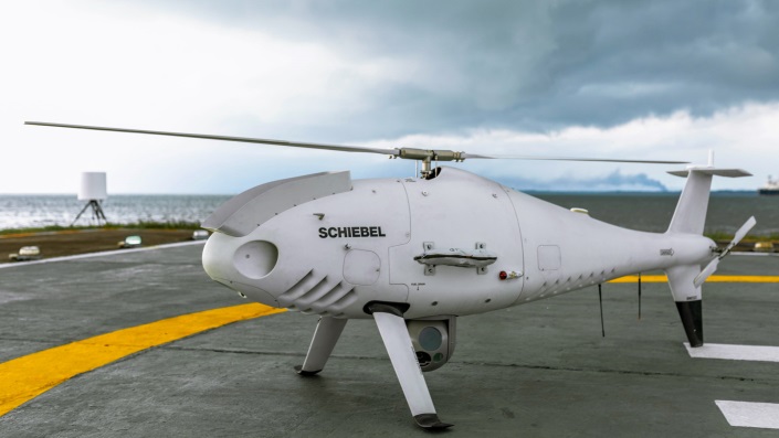
Kongsberg Geospatial in Ottawa, Canada has developed location visualization software tools that are used for air-traffic control, command and control, and air defense applications. The company has several decades of experience in these applications. Its IRIS software was used to support recent UAV oil pipeline inspection operations in Nigeria, providing safety critical airspace deconfliction, supervised by the Nigerian Civil Aviation Authority (NCAA).
The pipeline project was undertaken by Aerial Robotix, a UAS services provider in Nigeria, who used adapted Kongsberg software in its control center to demonstrate safe BVLOS operations, and was then able to obtain the necessary permits. A Schiebel Camcopter S-100 UAV with a 200-kilometer BVLOS capability was used for flight inspection, operating both day and night, with real time high-definition payload imagery sent back to the control station.
Camcopter S-100 prior to BVLOS pipeline inspection flight in Nigeria. (Photo: Schiebel)
Nigeria has a major problem with gasoline theft from pipelines similar to those lines inspected during this project. Recently, 105 people perished in a blast from a ruptured pipe 30 miles north of the city of Umuahia, possibly during scavenging for leaking fuel. It has been claimed that the pipeline had been ruptured by saboteurs earlier, and for the following six weeks villagers had been collecting fuel. Pipeline vandalism is common in Nigeria, even given the risk of fire or explosion, or the risk of prosecution, or even the possibility of being shot on sight.
Unmanned Companion Fighter Aircraft
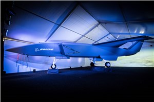
Boeing just unveiled a concept UAV which is apparently aimed at providing an airborne team-partner for manned aircraft.The concept was introduced at the Australian International Airshow by the Australian Minister for Defense, the Hon. Christopher Pyne MP. The project is slated for a significant R&D investment by the Australian Government and Boeing Australia.
Boeing Airpower Teaming System. (Photo: Boeing Company)Boeing Airpower Teaming System. (Photo: Boeing Company)
The concept model has fighter aircraft lines with a projected 2,000-mile range, autonomous capability, and significant intelligence, surveillance and reconnaissance sensor capability. Flying alongside manned fighter/attack aircraft with artificial intelligence simplifying control, the Airpower Teaming System is designed as a low-cost force multiplier.
The concept includes a pitch for international collaboration offering significant customization so countries can add local content, a key element for any aircraft program designed for off-shore sales.
XQ-58A demonstrator in flight. (Photo: U.S. Air Force)
A day or so after the Airshow (maybe not wanting to be upstaged by Boeing’s announcement?) a release showed up about the first flight of the previously secret XQ-58A Valkyrie demonstrator. This is apparently a program by the US Air Force Research Laboratory (AFRL) partnered with Kratos Unmanned Aerial Systems to develop a UAS which looks to have very similar capabilities to that of the Boeing concept, perhaps at a significantly further advanced stage, with a much more mil-spec UAV sounding name.
The AFRL indicated that the XQ-58A is part of a Low Cost Attritable Aircraft Technology (LCAAT) (guess that means they don’t much mind losing a few) effort to come up with low-cost force multipliers which can be built quickly using commercial technology and operating from unprepared runways.
(From the Air Force: “The thought is to develop an inexpensive, configurable and producible on demand air vehicle. A number of military applications can be envisioned for an air vehicle with such a capability. One potential application is to use hundreds or thousands of such units in a campaign to overwhelm an enemy’s air defenses and “punch a hole” to enable higher value, less replaceable [aircraft] to engage or monitor enemy systems. Another potential application is to augment the capabilities of high-value intelligence, surveillance and reconnaissance, systems which may be limited in a specific campaign by distances, quantities, or threats. For all applications, the weapon system is expected to be an air vehicle that would return to base or to a separate location to be recovered. However, because of the mission and because of the low cost, the air vehicle would be attritable, meaning the Air Force would expect and could afford to lose many of the assets.”)
The current program took 2½ years to get to this flying prototype, which still seems pretty lengthy in terms of today’s commercial UAVs. The first flight from Yuma Proving Grounds in Arizona lasted an hour and a quarter and all went as expected. Five test flights are planned to check out functionality, aerodynamics, and launch and recovery systems. Kratos is perhaps better known for its family of target drones which have been in use by the US and internationally for some time.
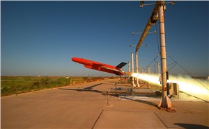
Kratos BQM-177 Navy drone declared operational. (Photo: Naval Air Systems Command)
Kratos Defense & Security Solutions, Inc. announced in early March that its BQM-177A Subsonic Aerial Target (SSAT) has achieved Initial Operational Capability as reported by the US Navy. A Navy statement said “The first site the BQM-177A will be operated from is Pt Mugu, California. The target is capable of speeds in excess of 0.9 Mach and a sea-skimming altitude as low as 10 feet which provides sea-skimming anti-ship cruise missile threat emulation for the US Navy.”
Parachute System for DJI Phantom 4
Recent testing of the descent rate of a Phantom 4 equipped with a SafeAir parachute system indicated that this UAV/parachute combination may well meet the FAA’s recently published draft rules for flight over people. The parachute system uses on-board indicators to trigger parachute deployment. ParaZero (manufacturer of the SafeAir UAV parachute system) has developed standards, and promises to provide customers with certification data to support waiver applications for flight over people.
Wrap-up
So now we have intuitive software using terrain data and sensor inputs which can provide a visual overlay to supports BVLOS flights, concepts designs and prototypes to support the ‘Loyal Wingman’ approach – flying UAVs alongside existing defense aircraft as force multipliers – and advances towards UAV flight over people using certified parachute safety systems. Just a flavor of the flurry of recent new developments in the world of unmanned aircraft.
Changes to the Federal Aviation Administration (FAA) operational drone restriction were recently proposed in order to allow some flights over people. This proposed rulemaking appears to be a major step forward. Mail-order delivery flights, newsgathering, real-estate sales movies and building inspection, to name a few markets, all begin to make more sense, maybe even become viable.
Some night operations could also be possible.
Risk assessment methodology appears to be logical; a number of UAV categories are proposed, and there is a way to assess if operators are in compliance.
The Alliance for System Safety of UAS through Research Excellence (ASSURE) undertook a ground impact study to determine the possible risk of injury to people from drones falling out of the sky. Assessments were made using existing automotive standards and a military standard for debris impact, plus there was testing using automotive crash dummies.
It was a lot of work, but the bottom line appears to be that possible injuries to people are more likely to be minor than major. Bear in mind that UAS fly at relatively low altitude, are made with materials that make them somewhat elastic in nature, and that it may be possible for people in a crowd to see a flailing, falling UAV and move to avoid an impact.
Nevertheless, I do have a picture in my mind of a wayward drone crashing to the pavement after hitting a skyscraper in San Francisco, and I’m really glad I wasn’t down on the sidewalk below.
Urban building inspection using drones. (Photo:AeroSIM RC)
Then I read an article by James Poss, a retired military major, who seems to suggest that although the conclusion of the ASSURE assessment was that 2,000 grams was an OK weight for an sUAV to avoid serious injury to anyone, the FAA appears to have proposed limitations for sUAS which are only 1/10th of this weight. This is more in line with the weights in the mil-spec standard that are based on small, fast, solid-metal blast fragments.
It might help us to also consider how often or badly people are injured by golf balls, baseballs, tennis balls or squash/racket balls — for instance, I’ve survived several golf ball impacts and even an impact with a squash racket during play without major damage. These are things we all take in our stride as part of (almost) normal human activity. I wonder how often recreational enthusiasts have actually been injured during model-aircraft flying gatherings?
FAA restricts flights over government facilities
In cooperation with the Department of Justice (DOJ) and the Department of Defense (DOD), the FAA has just established temporary restrictions on drone flights within 400 feet of the lateral boundaries of a number of sensitive federal facilities. This is in addition to previous restrictions over prisons, NGA facilities, DoD ships and other facilities.
The most recent proposed Notice to Airmen (NOTAM) lists federal correctional facilities in almost half of the states in the U.S., several medical centers, U.S. Army facilities, ammunition plants and Pearl Harbor in Hawaii. It’s hard to understand why there aren’t already permanent UAV prohibitions over all such sensitive facilities across the whole U.S. I tried to check status, but the FAA UAS Data Display System didn’t list this proposed NOTAM which apparently goes into force on Feb. 26.
Think it’s probably a question of preventing bad guys from planning or doing harm rather than being shy to be caught on video — but, for sure, these places should be as secure as possible.
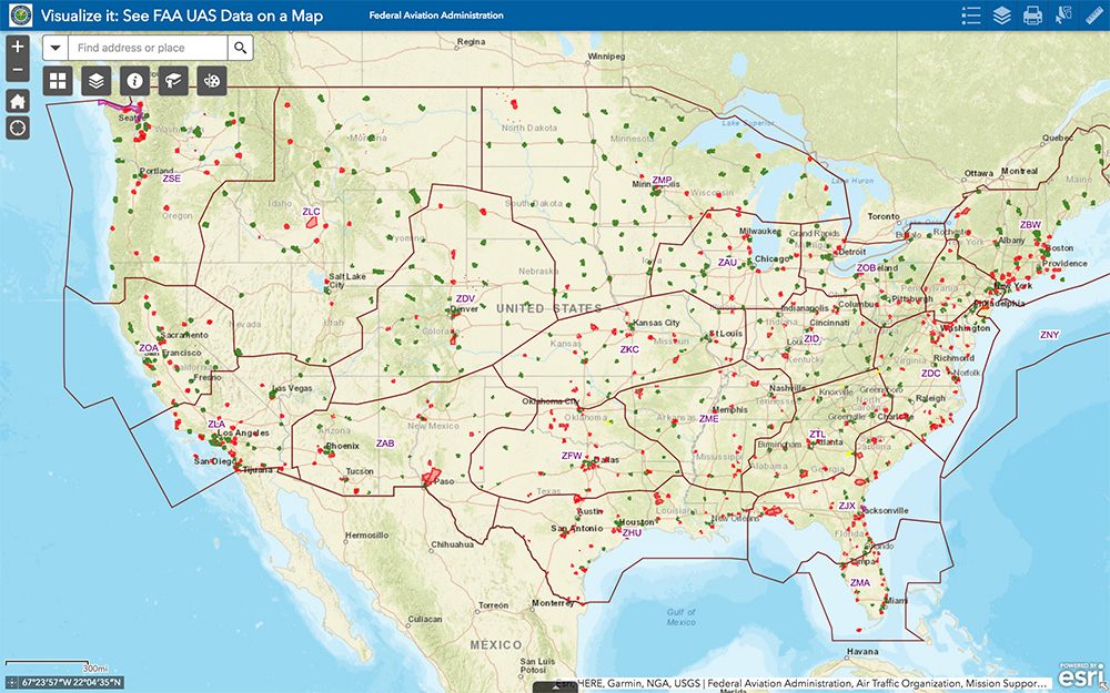
The FAA UAS data map shows all drone-restricted areas, once updated. (Screenshot: FAA)
Security at the Super Bowl
Well the game wasn’t the most exciting, with New England doing all that was needed to win in the fourth quarter, but the security for the event in Atlanta was humongous.
The area around the stadium was cleared of threats even before the game, attendees were screened for prohibited items and the airspace within 30 miles was restricted for general aviation and drone access. There were even Defense Department F-16 airspace patrols, and the Customs and Border Patrol had a Black Hawk helicopter available to intercept any aircraft penetrating the exclusion zone.
Nevertheless, the FAA still approved the operation of two tethered drones. One was flown close to the stadium by security personnel to provide live images of crowd movements in and around the stadium. The second system was operated at 45 meters above the rooftop of the CNN building facing the Mercedes Benz Stadium. CNN used it to provide aerial imagery of the scene before and after the game.
Elistair base station and DJI M200 at Super Bowl. (Photo: Elistair)
The tethered drone setup included two DJI M200 drones and two Elistair Ligh-T base stations, with monitoring, control and power provided to each drone by lightweight tethers. The security system was continuously operationed for 10 hours of captive flight during the Super Bowl, and for 14 hours total over two days — all while tethered to the Ligh-T control station. Security officials expressed their interest in using this solution more often because of the ability to follow a subject continuously without having to switch from one fixed camera to another, which risks losing the subject.
To sum up, new pending FAA regulations that support operations over people may have a few flaws. Other new FAA rules are aimed at protecting DOD and DOJ facilities from drone overflights, and tethered drones were used at the Super Bowl for crowd security and by CNN for color coverage.
New applications, new opportunities and preventive controls to maintain security at sensitive facilities — all moving in the right direction.