Looking around the industry over the last few weeks, there continues to be a flood of innovation that promises new approaches for unmanned aircraft in addressing several new opportunities. This month I cover a flying taxi at the 2019 Consumer Electronics Show (CES) in Las Vegas, greater range for multi-copters using fuel cells, a potential huge drone in the making, and a potential Florida controversy over use of a tethered aerostat — interesting stuff!
Bell Flying Car/Air Taxi
At CES of all places, there was a new idea for air-taxis — not yet a UAV, but with the promise of future autonomous flight, it surely deserves a mention. Bell brought its latest commercial vertical take-off and landing (VTOL) mock-up to CES to test the level of interest in its concept of a flying car.
Lift and directional flight control are provided by six 8-foot ducted fans, each driven by its own electric motor and powered by a turbine-driven electric generation and back-up battery system. Using technology derived from the mil-spec V-22 Osprey Tilt-Rotor and its commercial V-280 cousin, the ducted fans pivot from horizontal for take-off to vertical for forward flight.
The concept vehicle at CES had a seat for the pilot, but the digital flight control system is envisaged to have autonomous flight capability — and there we have another approach for a UAV flying car/air-taxi — from one of the mainstay aviation manufacturers of helicopters with all the necessary experience to make it happen.
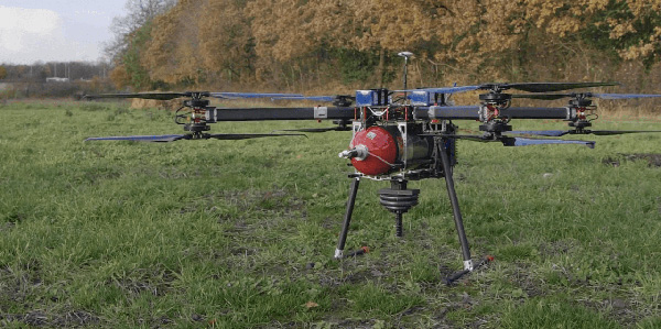
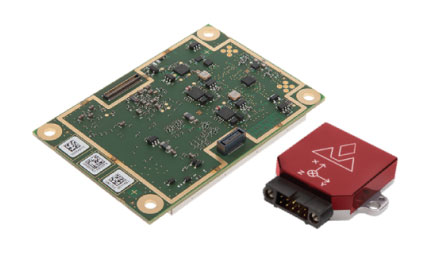
Fuel-Cell-Powered UAV Flies for 70 Minutes
There’s apparently a new way to overcome the short duration that is currently available for flying existing multi-rotor drones — don’t just rely on batteries, use hydrogen! Actually a hydrogen fuel-cell configuration that has recently been tested in the UK to extend flight time to 70 minutes, while carrying a 5-kg payload.
Test-drone with Intelligent Energy Hydrogen Fuel-Cell. (AVI screenshot supplied by Productiv)
The UK team includes Intelligent Energy, which supplies the fuel-cell, engineering firm Productiv, and UAS video company BATCAM, with funding provided by Innovate UK, a government-sponsored group that supports novel ventures such as this joint project.
Most existing battery-powered multi-rotor UAVs have endurance in the tens of minute (DJI seems to be approaching 20-30 minutes with some of its drone models). But longer endurance is really important for most operators, especially for capturing lengthy video, hence the interest and participation of BATCAM as the operator/consultant for the project.
Fuel cells provide a number of advantages over batteries with fast refuel, little vibration, quiet operation, zero emission at point of use, and around three times longer flight time. Intelligent Energy is making use of a portable hydrogen refueling system supplied by NanoSUN.
With BATCAM set to begin operational trials, the company is optimistic that further development of hydrogen fuel cells for UAVs will not only enable even longer video broadcasts but will solve the problem encountered with the difficult and expensive international transportation of Lithium polymer batteries.
Airship Moves towards Civil Certification
While we are in the UK, a huge 300-foot-long helium-filled airship called the Airlander 10 is again moving steadily down the path to gain civil approval by the Civil Aviation Authority (CAA), despite a previous crash in November 2017 due to a wayward landing cable.
The latest milestone was just achieved at the end of 2018 when CAA awarded Hybrid Air Vehicles Ltd. (HAV) a Production Organisation Approval, following on from earlier Design Organisation Approval by the European Aviation Safety Agency (EASA) in October 2018.
This behemoth airship is claimed to be the largest aircraft in the world, can carry 10 tons of cargo virtually anywhere on earth, stays airborne for up to five days, and can land almost anywhere. Powered by two forward-mounted rotating ducted fans and two aft fixed fans, all driven by diesel engines, the pressurized helium-filled envelope is 302 feet long, 143 feet wide, 85 feet tall, and has no internal support structures — all this with a cruise speed of up to 80 knots and a maximum altitude of 20,000 feet.
The Airlander is aimed at bulk cargo transport, but could also handle communication and observation/reconnaissance roles in both the military and commercial sectors. And it’s not so far away from becoming the largest unmanned aircraft in the world, either, should things eventually turn in that direction. Could there be potential for a greater payload without the extensive provisions for a pilot, with lower operating costs, potentially greater range and speed and/or operational altitude?
Miami Police use Tethered Aerostat
Miami police have been using a tethered aerostat to monitor large gatherings, such as the Dec. 28 Orange Bowl-related party called the Capital One Beach Bash. Presumably this use had a safety related motivation, and there was hopefully no intent to spy on partygoers.
However, I just became aware that police cannot fly drones in Florida to surveil people — there’s a law against it. But there is a provision in the Florida “Freedom from Unwarranted Surveillance Act,” which starts off: “If the law enforcement agency possesses reasonable suspicion that, under particular circumstances, swift action is needed to prevent imminent danger to life or serious damage to property,…”. Now, I’m no lawyer, but it would seem that this exclusion might possibly allow the Miami cops to monitor large gatherings where there might be a need to watch out for people’s safety – that generally being what we employ the police to do for us.
But the Florida lawmakers certainly believe that there is clearly a need to protect people’s privacy and to prevent unauthorized monitoring of an individual’s activities using drones. The provisions of Florida Statute 934.50 prohibits “the observation of such persons with sufficient visual clarity to be able to obtain information about their identity, habits, conduct, movements, or whereabouts” — a good thing to do to protect our freedom of movement and basic rights.
But you have to ask yourself if a general prohibition on the use of drones by police is the best thing to do when other police departments around the U.S. are gaining advantages from drone usage by speeding up and improving the accuracy of traffic accident investigations, for search and rescue, in crime scene reconstruction, for disaster response, and of course for improving officer safety — in fact, all the things that are already achieved through the use of police helicopters, but at a fraction of the cost.
Florida Statute 934.50 already has a significant number of allowable exceptions to enable a “law enforcement agency” and others to operate drones legally, but could it also be possible that these wider benefits of drone use might be fully exempted without infringing any personal liberties?
Conclusion
To sum up, we have a big aerospace company jumping in to help shape the future of unmanned air taxis; another drone fuel-cell application that significantly extends flight time; and progress towards certification of an airship that has benefits as a drone. Finally, police use of a tethered aerostat at an event stirs potential controversy, while other police forces benefit from the use of drones — a mixed bag of drone ventures that seem to have great potential.
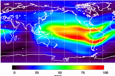
Space Based Augmentation Systems (SBAS) – known in North America as the Federal Aviation Administration’s (FAA’s) Wide Area Augmentation System (WAAS) – have been fully operational in one form or another for several years. The FAA’s incremental improvements to integrity, accuracy and reliability in WAAS have brought the system to a point where we have precision en-route navigation for aircraft, and we can also land aircraft using WAAS signals at thousands of airports in the US and in Canada.
Why not Mexico, which also benefits from the same WAAS coverage? More on that later, as we piece together the many parts of the complex SBAS mosaic.
SBAS precision approach coverage, May 2016. Graphic: FAA Tech Center, Lockheed Martin, GMV
Europe benefits from high-accuracy en-route navigation, and there are also hundreds of operational approaches using the European Geostationary Navigation Overlay Service (EGNOS) SBAS.
In India, the GPS Aided Geo-Augmented Navigation (GAGAN) system provides accurate en-route navigation and approach capability. However, ionospheric disturbance may limit some aspects of performance.
Japan established the Multi-functional Satellite Augmentation System (MSAS) SBAS, and has benefited from improved en-route navigation, but it’s possible that the more limited geographic distribution of GPS ground reference stations has restricted improvements to approach capabilities.
But what happened to the International Civil Aviation Organization (ICAO) concept from 2007, supported by all the ‘aviation-going’ countries of the world, that SBAS would evolve and eventually multiple national systems would provide coverage around the rest of the world, maybe even by 2016?
Countries in Asia, South America, Africa and the continent of Australia all appear to have looked closely into establishing their own SBAS, but nothing seems to have come out of these investigations. Technical issues, cost, and political obstacles have all hindered global SBAS progress.
The ionospheric challenge. Graphic: GMV and Lockheed-Martin
Technical Issues. Ionospheric scintillation problems around the Equator seem to be at the root of most technical problems for SBAS. Getting to the required level of probable, bounded system error is hugely difficult. The iono disturbance ‘blob’ follows the sun around the Equator and wipes out any chance of satisfactory system performance when it passes over Equatorial countries.
As total electron count (TEC) increases, the ionospheric grid, which most SBAS use to predict ionospheric variation across their geographic area between fixed reference stations, well, it just doesn’t work anymore.
Cost. The capital cost of building a satellite-based augmentation system and the on-going cost of maintaining a bunch of geographically distributed reference sites, building and launching GEO satellites or renting transponders on someone else’s orbiting asset, establishing, operating and maintaining redundant uplink stations, redundant terrestrial data links, and setting up control systems that collect and create the SBAS uplink message — it all adds up. Millions and maybe even billions of dollars or equivalent, in total, have been spent by those select countries who could afford their own SBAS. Others named above have lesser financial resources upon which to draw.
Political Obstacles. One of the trickiest issues is sovereignty: the need for a country to control its own navigation and landing system. This has likely been the source of most resistance to more SBAS systems being set up and shared by bordering countries around the world.
For a large number of smaller countries, SBAS would only make sense if it was shared across a number of neighboring countries, but that means relinquishing sovereignty to some degree. In several regions of the world a number of geographically adjacent countries don’t particularly like each other, never mind thinking of such sharing/collaboration.
National sovereignty, by the way, isone of the main reasons that existing satellite navigation systems underpinning SBAS, such as Galileo, GLONASS, IRNSS (now NAVIC), QZSS and of course BeiDou have all been put in place.
Another problem with potential SBAS sharing across adjacent countries stems from responsibility for liability. Should something not work and an accident ensues from such a malfunction, who’s liable? Mexico seems to have adopted the view that since the US provides WAAS on what could be called an ‘as-is’ basis, then the potential liability issue seems to trump using the system.
Solutions? Technical issues with the ionosphere may soon be resolved by using dual-frequency L1/L5 airborne receivers that directly calculate their own ionospheric corrections, rather than using the computed SBAS iono grid. If we add in dual-frequency E1/E5a signals from Galileo, things start to get even better. New requirements and prototype equipment are already being developed for dual frequency multi-constellation airborne receivers. Airbus anticipates equipping aircraft with such receivers around 2025. Could this solve the SBAS technical issue for Equatorial countries?
ARINC (now a UTC/Rockwell Collins company) and SITA (in Europe) have been providing commercial aircraft with operational communications services on a pay-for-use basis for a number of years, and this is notarized as an accepted means of compliance within ICAO policy/requirements:
From ICAO Doc. 9161, Sec. 3.99: “A group of states or a regional organization might also undertake to operate the augmentation satellite service required, either by themselves or by contracting a commercial or government organization to do so on their behalf.”
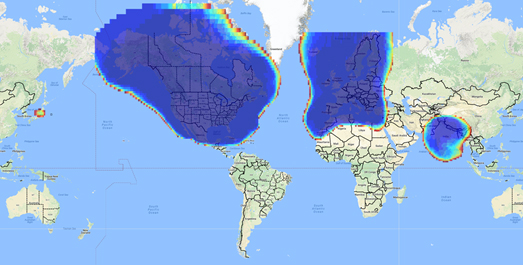
ARINC en-route coverage. Graphic: ARINC
Aireon has partnered with NAV CANADA, the Irish Aviation Authority (IAA), Enav, NATS and Naviair, as well as Iridium Communications and Harris Corporation to provide real time ADS-B data (GPS position output from aircraft) to air-traffic control providers. Aireon’s payloads on the new Iridium NEXT Low-Earth Orbit (LEO) satellite constellation will receive aircraft ADS-B messages and relay them to Air Traffic Controllers in real-time.
There are 66 Iridium NEXT satellites in operation, with significant overlap and redundancy built into the system to enable this safety-of-life service to be provided on a pay-for-use basis to the aviation industry. We could at last know the location of every suitably equipped aircraft in the air, in almost real-time. The ICAO requirement is for an update rate of 15 minutes.
Inmarsat ADS-C is a similar service available to aircraft on a contracted, pay-for-use basis via Inmarsat GEO satellites.
Market Solutions. If a substantial company showed up with a worldwide distributed SBAS solution and offered it on a fee for service basis, why wouldn’t countries that are already accustomed to ARINC and SITA pay-for-use communications? The Aireon international aircraft tracking system, to be provided on the same basis, adds to the credibility of such a pay-for-use service.
So why wouldn’t these accepted services demonstrate to those countries concerned about control and national sovereignty that an SBAS service could be provided on this basis?
The liability for provision of service sits with the providers, so user countries/airlines would have someone to turn to about liability issues, and there presumably could be contract terms to provide system performance guarantees.
No huge capital costs, no system to construct, nor staff to operate or maintain, and yet a level of control similar to that which has been around for commercial aircraft communications for decades.
Would this be of interest to countries that have not yet jumped on the SBAS bandwagon? A definite ‘maybe,’ we could imagine? What’s not to like?
The punch line to all this is that Lockheed Martin and GMV (Spain) have teamed to challenge these non-SBAS countries with a solution which may appeal.
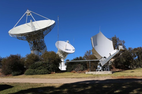
Uralla reference test site. Photo: Lockheed-Martin
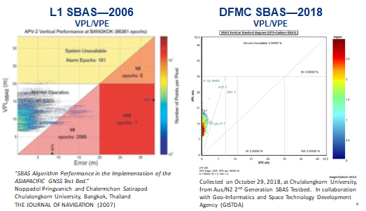
To present convincing evidence that it would work, a dual frequency GPS (L1/L2) + Galileo (E1/E5a) reference site has been set up in collaboration with Geoscience Australia and Land Information New Zealand. The reference site is located at Uralla, New South Wales on Australia’s East Coast, where it gathers data demonstrating bounded errors within the operational range which could enable GNSS approach capability.
L1 (2006) vs. DFMC (2018) SBAS at Bangkok. Graphic: Lockheed-Martin, GMV
Another test site in Bangkok, Thailand has demonstrated that existing L1-only SBAS in this area cannot manage this performance (all current SBAS are L1 only), but that with dual-frequency multi-constellation (DFMC) GPS L1/L2+Galileo E1/E5a, the required performance limits could be met.
Lockheed Martin has also been using the Uralla uplink site to test the uplink and downlink of dual-frequency SBAS-like test messages.
The Moral of the Story. There are no miracles as yet, but interest in the pay-as-you-go SBAS concept appears to be growing, and the LM/GMV team continues to work to bring their approach to market.
A large number of countries could well benefit from the high accuracy, integrity and continuity of SBAS service if this all comes together.
This report covers a number of UAV topics, including the news of another U.S. Federal Aviation Administration (FAA) program to advance drone integration in the U.S. National Airspace System (NAS); an initial effort towards Type Certification for a larger UAV/UAS; cautious steps to protect U.S. Navy and Coast Guard ships from unwanted drone overflight; and what would appear to be a surge in the number of acquisitions across the industry.
FAA Integration Pilot Program
There are signs of growing momentum to get UAVs flying in the U.S. NAS. The FAA Integration Pilot Program (IPP) website indicates that this latest initiative is spread across a number of different applications, locations and supporting organizations. The FAA cites the following objectives for IPP:
Connecting local and national UAS integration interests
Improving local, state and tribal communications
Addressing security and privacy risks
Speeding up special authorizations.
So it’s perhaps more about getting organizations at the local level into the picture, and fostering cooperation with national interests. But, at the same time, pilot projects will feed knowledge into the hopper of how to get UAVs into the U.S. NAS.
Operational concepts to be investigated include night operations, flights over people, flights beyond visual line of sight, package delivery trails, testing detect-and-avoid technologies and verifying the reliability and security of UAS data links.
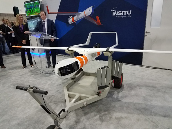
Certification Program underway for Insitu ScanEagle3
Along the same lines, Insitu is working with FAA staff towards certification of the commercial ScanEagle3 drone system to enable flights in U.S. controlled airspace. A recent three-day Type Certification Board meeting held between FAA and Insitu included launch-to-capture flight tests, plus review of applicable standards, flight training and technical publications and manuals to determine Insitu’s basis for the proposed UAS Type Certification of the ScanEagle3 in 2019.
Once an aircraft or UAS gains Type Certification, it should be possible to fly that model on a regular basis, without the need for special FAA authorization of individual operations, as is currently the requirement for drones — other than for small UAS (sUAS), which already have FAA approved operational regulations. This effort could also clear the way for certification of larger drones to regularly operate in the NAS. Filing a flight plan with local FAA controllers prior to each flight would then typically be required, as is standard for all manned aircraft.
FAA review teams examine Insitu’s ScanEagle3 at a type certification board meeting in Bingen, Washington (Photo: Insitu)
At the recent review meeting with FAA team members from various certification groups, Insitu discussed its internal culture of safety, which is in line with the FAA’s extremely strict safety standards. The design and technology of ScanEagle3 was demonstrated, and the maturity of Insitu as an aircraft manufacturer was emphasized.
The FAA teams participated in an overview of Insitu’s Project Plan for Certification, examining Insitu’s detect-and-avoid (DAA) capability planning, safety management system and model-based engineering processes.
Insitu is hopeful that Type Certification will enable ScanEagle3 to be applied quickly to all types of operation, which could include data collection, analysis and delivery; aerial infrastructure survey; disaster recovery; and wildfire suppression – without the delay currently associated with seeking permits and overcoming temporary flight restrictions.
FAA restricts drone operations near sensitive U.S. facilities
Meanwhile, the FAA flexed its legal muscles to restrict drone flights near U.S. Navy (USN), U.S. Coast Guard (USCG) and Department of Energy (DoE) facilities and assets. Growing concerns with potential malicious drone flights over sensitive, high-priority facilities and ships apparently prompted the FAA to issue two NOTAMs (Notice to Airmen). The first notification describes the locations and the assets – in this case, ships operating from two bases — and includes the form of restrictions that are being applied.
Drone flights have been restricted around USN and USCG vessels operating near Naval Base Kitsap in Washington state and Naval Submarine Base Kings Bay in Georgia. Drones are not allowed to get closer than 3,000 feet laterally and 1,000 feet vertically from vessels. And the NOTAMs carry the dire warning that these ships have the authorization and ability to take whatever action they feel necessary to protect themselves from such threats.
In other words, if the nut-case flying an unwelcome drone penetrates the restricted area around a Navy or Coast Guard ship, the target ship might well take out the unwanted drone. And the FAA may also pursue civil penalties and/or criminal charges against the operator for disobeying the restrictive notice.
The second NOTAM warns drone flyers to remain clear of all national Department of Defense (DoD) and DoE facilities and mobile assets, as well as USCG vessels. With UAVs carrying explosive devices becoming more common in areas of conflict or political unrest (in Venezuela, for instance), it’s not surprising that U.S. DoD is concerned this could soon start to happen closer to home.
Industry consolidation continues
Finally, following a letter of intent from Textron Systems to buy Howe & Howe Technologies a land mobile robotics defense outfit, drone industry consolidation also seems to be gaining momentum.
Howe & Howe’s land vehicles are built and proven for extreme environmental conditions, and U.S. government customers have selected Howe & Howe’s small, highly mobile Ripsaw Super Tank for its speed, mobility and off-road performance, while the RS2-H1 SMET was down-selected to compete to be the U.S. Army’s first platoon load-carrying robot, after completing a 60-mile test through swamp and jungle terrains.
Textron Systems continues to position itself as a global leader in autonomy applications in air, land and sea.
In addition, Delair has just announced an agreement to acquire the key assets of Airware — a developer of software analytics tools for data collected by drones. The acquisition quickens Delair’s growth and increases options for the commercial UAV market. Delair provides end-to-end solutions, including fixed-wing drones, cloud-based data processing and analysis, local customer support and custom consulting services.
Delair UX11 mapping drone (Photo: Delair)
The acquisition is through an asset purchase of Airware’s technology, including proven software, related personnel in Paris, existing customer relations and established distribution channels. Airware’s data management and data analysis tools will be highly complementary with Delair’s existing solutions and will also expand Delair’s U.S. market presence, providing access to additional key industrial markets.
Airware, based in California, has provided a cloud-based software solution to large companies in the construction, mining and insurance industries. Its software solution was developed with support from Caterpillar and has been distributed by Caterpillar dealers to more than 50 countries to improve the productivity and safety in mines, quarries and construction sites.
Delair, with more than 180 employees worldwide, has customers in a number of industries including mining, construction, energy, utilities, oil and gas, transportation and security.
PrecisionHawk has also announced the purchase of Uplift Data Partners, which provides turnkey inspection services for construction, building information management (BIM) and real-estate. This is PrecisionHawk’s fifth acquisition during 2018 — earlier acquisitions have included Droners.io, Airvid, HAZON and InspecTools. These acquisitions have created dynamic synergy, and provided enhanced airborne intelligence with strengthened data value for PrecisionHawk.
Uplift’s commercially trained drone pilots will join PrecisionHawk’s network of more than 15,000 drone pilots, one of the largest networks of its kind. Suzanne El-Moursi, CEO of Uplift, will join PrecisionHawk’s executive team and will manage the company’s construction business.
The intent is for customers to receive best-in-class aerial data and analytics for complex construction and facility inspection projects, through combined PrecisionHawk’s advanced products and services, and Uplift’s industry experience and training standards.
PrecisionHawk and Uplink will combine products for construction projects. (Photo: PrecisionHawk)
Uplift Data Partners has been an integrated subsidiary of Clayco, an architecture, engineering, design-build and construction firm, with more than $2 billion in annual revenue. Following the spin-off, Clayco will still source its construction projects exclusively to PrecisionHawk, and will support PrecisionHawk’s board of advisors.
The construction industry has rapidly adopted commercial drone technology — transforming construction processes by decreasing the need for protracted visual inspections, shortening planning time, improving worker safety and quickly identifying problems.
And finally — Microdrones, a provider of professional UAV solutions, has announced that it has acquired geomatics service provider Navmatica Middle East (ME) with an office and team in Dubai, UAE. Navmatica ME supplies services and custom software development for geodetic positioning, airborne mapping, mobile mapping and indoor mapping.
Microdrones md4-3000 drone. (Photo: Microdrones)
The acquisition establishes a foothold in the Middle East market for commercial drones, and adds an experienced team of geomatics engineering specialists, software developers and systems engineers who have a proven track record of providing customers with high-quality geomatics services and technology.
Summary
We have FAA efforts to move further forward with UAV integration with its IPP program, first steps down the lengthy and somewhat arduous path towards the certification of larger UAVs to enable less restrictive flight in the U.S. NAS, notifications to operators to improve protection of Navy and Coast Guard ships from unwanted overflight and potential drone attack, and plenty of signs of drone service and manufacturer business consolidation — lots of what we may think of as positive indications of greater maturity and progress for the UAV industry.
Another month, another hurricane in the southern United States. News channels showed drone-captured video of the mess left behind in Northern Florida, Georgia and the Carolinas. More useful is the video damage assessments UAVs are providing for first responders.
A basketball hoop and backboard hang forlornly while both front and back walls of a school gym are gone, huge buildings are nothing but matchsticks, fallen trees and powerlines blocking roads — familiar scenes from hurricane Michael’s devastation of Panama City and area — video provided by drones operating in the disaster zone.
Although the videos have now largely gone from the TV news, Panhandle residents will be living through this nightmare for months to come.
Photo: Glenn Fawcett/Customs and Border Protection/Handout)
Working with emergency teams — including the North Carolina Surf City Fire Department, Airborne Response, Florida FEMA Task Force and Missouri Task Force FEMA — Edgybees’ AR drone software was able to provide collaborative, real-time, situational visualizations of the areas affected by Michael. Status and location updates were available during critical missions, and key geographical data was provided to teams on the ground.
Beach Patrol
Another life-saving drone application comes from the other side of the Pacific – finding and deterring sharks which threaten bathers off the beaches of Australia.
An artificial intelligence application on-board a SharkSpotter UAV monitors for shark attributes as it overflies inshore areas where the predators are known to hunt. If there is a match for typical shark behavior — size, shape, color, and movements in the water — an alert is transmitted to enable lifesavers to respond. The drone can even drop a flotation device to swimmers in trouble. A number of beaches in New South Wales were patroled this past summer, and many more UAV beach patrols are planned to be added for the coming season.
SharkSpotter drone. (Photo: Ripper Group)
Other work is underway to deter the animals using devices in the water which create electric fields aimed at interfering with shark sensory systems. Another cell-phone application estimates the probability of the presence of sharks based on a number of environmental factors. Several U.S. agencies are keenly watching these developments as shark attacks have increased here, off both Atlantic and Pacific beaches.
Meanwhile, there has been another important step forward for drone integration into the US National Airspace System (NAS) and for integration in other countries’ airspace. Enabling drones to fly over people and property is a key part of potential airspace operations, and a safe recovery system which avoids possible injury to people is becoming essential. Most drones have a return-to-base fallback in the event of loss of the control signal, but this doesn’t help in the event of a fundamental mechanical failure.
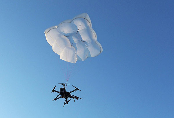
Parachute Recovery Systems
DJI Matrice 600 with DRS-10 rescue system. (Photo: Drone Rescue)
Effective auto-release parachute systems may be key to solving this problem. Another supplier has emerged with a lightweight automatic system for the DJI Matrice 600 multicopter.
Drone Rescue (DR) from Austria has announced its DR-10 parachute recovery system,for drones weighing 5-20 kg (11-44 lb). The DR-5 system is for lighter UAVs (8kg – 17.6lb).
The DRS-M600 system has apparently been derived from the DR-10 specifically for the DJI Matrice drone.
Photo: Drone Rescue
The parachute is mounted in a carbon cage and is released when a self-contained electronics system automatically detects an imminent crash. DR claims that their system works even in the event of control data link failure, and that incident data is collected in an on-board UAV flight-data recorder for subsequent analysis.
It was previously announced that an FAA waiver for flight over people was granted to North Dakota UAS operator, Botlink using a ParaZero Israel drone recovery parachute system.
Initial flights were conducted during a tailgating event prior to the North Dakota State University vs South Dakota State football game in North Dakota. The drone flew over crowds in the stadium’s parking lots and provided real-time video for local law enforcement and media companies.
This drone parachute safety system includes a fully autonomous triggering system that deploys quickly and reliably without being dependent on any manual operator’s response. During FAA testing it was necessary to demonstrate that the descent rate was slow enough to provide acceptably low impact energy and that the system would operate correctly in multiple types of failure conditions.
DHL Drone Delivery
Meanwhile, DHL has joined other drone delivery companies to establish a medical delivery trial in Africa. DHL’s trial is in the Lake Victoria region of Tanzania.
The six-month trial has focused on delivered medicines by UAV within 40 minutes to an island in Lake Victoria — the trip normally takes six hours by road.
Photo: DHL
Over the course of 160 proving flights, using a 4-kg-capacity Wingcopter, medical supplies were successfully transported over the 60 kilometers between Mwanza and the hospital on the island of Ukerewe.
The medicines reach their destination at least 3 hours earlier than by any traditional mode of transportation, and as a result of these tests, 400,000 people in the Ukerewe District will now have access to medical care and support in hours rather than days.
Conclusion
Drones helping out hurricane Michael recovery efforts in the Florida Panhandle, specialized drones tracking sharks to mitigate possible attacks off beaches in Australia, parachute recovery systems enabling drone flights over people, the integration of drones into regular airspace moving ahead, and more medical delivery trials in Africa. These are a few recent UAV applications that appear to be supporting even further drone use around the world.
Special section, October 2018 GPS World. Cover photo: PrecisionHawk
If you blink, you might miss something! The examples here represent only a fraction of this booming field, but they show how diverse drone use has become. Interspersed among them, this article offers further insights on technology integration, the regulatory outlook and the economic future of this fast-moving industry.
By Tony Murfin, Contributing Editor, UAV & Professional OEM
Capturing where the drone industry has been this year and where it is headed in 2019 resembles trying to describe a Florida thunderstorm: how can there be so much rain so quickly, how long will it last, and what will the landscape look like afterwards? (I’m writing this during just such a deluge near Venice on the Gulf Coast.)
The UAV/UAS industry has grown at such an amazing rate, it’s almost impossible to count or describe all the applications that have become normal practice, not to mention the number of companies involved in either making drone platforms or supplying drone integrators with sensors: GNSS, inertial, lidar, cameras photographic, thermal, infrared, video and more.
From accident reporting to crop monitoring to infrastructure inspections, drones are, so to speak, on the rise. This year we have seen substantial increases in investments by equipment suppliers, continuing funding for military businesses, prototype systems for remotely identifying and even taking down drones, and vastly expanded use in mapping and survey.
As precision guidance, autonomous operations, high-definition geocoded images and high-volume data processing all improve, drone usage will continue to increase. OEM receiver manufacturers, sensor suppliers and data-handling companies play key roles in development, and stand to profit thereby.
The Delair Septentrio UX11 mapping UAV. (Image: Septentrio)
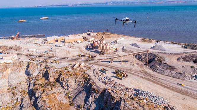
In particular, use of drones is growing in land management, construction, mining and farming. An open-pit mine operation can be supported through detailed drone inspection producing high-resolution images. Processed images and data enable keeping tabs on inventory, site changes over time, identifying best areas for further extraction, and monitoring and managing vehicle movement. These tasks required huge amounts of time in the past. Drone overflight and processing tools condense all the effort as well as producing enhanced results to enable faster and clearer decision-making.
Surveillance and reconnaissance are probably the biggest military drone applications. Carrying payloads that include color video cameras and infrared night vision cameras, more than 19,000 drones are now in the arsenal of the U.S. Army, Air Force, Marines and Special Ops, and more have gone to other nations’ militaries. Some fly at relatively low altitude, with limited range and powered by a single quiet electric motor; these drones have become essential in gathering forward-situation intelligence.
The following examples represent only a small part of the industry. I selected them here to show how diverse drone use has become. Interspersed among them, I’ll offer further observations on technology integration, the regulatory outlook and the economic future of this fast-moving industry. If you blink, you might miss something!
Accident Investigations
In the past, when police arrived at a serious traffic accident, investigators had to use tape measures and roller wheels to construct an accurate physical record of the incident. More recently, police have used laser measuring tools but this still entails time-consuming procedures and produces traffic back-ups. Now police departments have started to collect highly accurate aerial images of traffic incidents using drones, and it’s proving quicker and more efficient.
UAVs collect photos and videos, and software then stitches multiple high-resolution images together into a 2D or 3D map. With geolocation annotation provided by the drone, investigators can then take measurements directly from visual accident records.
Previously, an investigation could take up to three hours gathering information manually, but with a drone overflying and documenting an accident this might be reduced to around 45 minutes. This clearly saves time and money for the police as well as drivers who suffer shorter traffic delays. With an investment of about $15,000 in drone hardware and training, payback can happen pretty quickly.
Overall UAV Market Growth
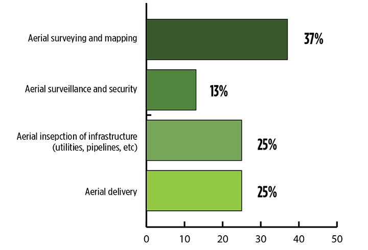
What is the killer app for drones? What professional UAV market sector will most powerfully drive adoption and influence new regulations for unmanned aerial vehicles? (Source: GPS World 2018 State of the GNSS Industry survey)
The drone logistics and transportation market was estimated to be valued at US $11.20 billion in 2022 and is projected to reach $29.06 billion by 2027, at a combined annual growth rate (CAGR) of 21.01%, according to India-based MarketsAndMarkets Research, in its May 2018 report.
The logistics and transportation market was defined to include warehousing, shipping, infrastructure, software, military, freight, and even passenger and ambulance drones. “The increasing use of unmanned aerial vehicles in civil and commercial applications for faster delivery of goods is one of the most significant factors expected to drive the growth of the drone logistics market,” stated the report.
The shipping segment is indeed projected to grow at the highest CAGR, as drones will see increasing use to transport a range of products from small packages to medical supplies and food. Venture capitalist investment in this market has been substantial as well as significant commitments by companies such as Amazon, Google, and Walmart in research and development to commercialize drone delivery services.
Couple that with another report from the same company report on the drone analytics market, valued at $1.17 billion in 2016 and projected to reach $5.41 billion by 2022, at a CAGR of 28.11% from 2017 to 2022. The drone analytics market was considered to encompass agriculture and forestry, construction, insurance, mining, utilities, telecommunications, oil and gas, and scientific research.
Both reports note that “The imposition of restrictions by various government agencies on the use of UAVs in civil and commercial applications is one of the major challenges faced by the drone logistics and transportation market.”
In February of this year, MarketsandMarkets estimated that the overall UAV market was valued at $18.14 billion in 2017 and projected to reach $52.3 billion by 2025, at a CAGR of 14.15%.
Agriculture
Results of a survey of 269 farmers by Munich Reinsurance America indicate that three quarters of all farmers in the U.S.— from those with less than 100 acres to those with more than 5,000 — have either begun to use drones for precision agriculture, and monitoring crops, livestock and soil conditions, or are thinking about using drones. Roughly half of these farmers contract out the work to drone service suppliers and most use drones either daily or more than once a week.
Sensor Integration
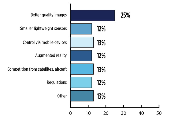
What is the biggest challenge for the UAV industry? (Source: GPS World 2018 State of the GNSS Industry survey)
As the size, weight and power (SWAP) and the accuracy of sensors continue to improve, drone use will continue increasing steadily. OEM receiver manufacturers, sensor suppliers and data-handling companies play key roles in this vital and ongoing development, and stand to profit thereby.
Making it all work is a combination of sensor payloads gathering inertial and GNSS location, stills and video, lidar, thermal and hyperspectral data; the secret sauce lies in how the data is processed and presented to users. All these areas show significant growth. The following are only a few key examples.
Lidar. Light detection and ranging (lidar) detects and measure the distance of an object or surface from an optical source, in this case a hovering or cruising UAV. GPS and inertial provide geo–referencing per each scan point.
Lidar has seen increasing application in surveying and engineering, GIS mapping, accident scene reconstruction, topographic and coastline mapping, digital elevation model and digital surface model generation, mining and quarries, gas and oil pipelines, railroads and other infrastructure. As hardware costs decline, software begins to play more and more of a major role, becoming a larger part of the solution in every way.
The M200 Snoopy series lidar package from LidarUSA is designed specifically for integration aboard the DJI M200 UAV. The laser scanning has a 100-meter maximum range, yielding 4-5 cm accuracy. It carries a tactical grade L1/L2 GPS/IMU unit and weighs 1.63 kg.
Inertial Miniaturization. UAVs are driving even further size-downs of other navigation sensors as well.
As just one example, the miniature μIMU from Inertial Sense incorporates a magnetometer, barometric pressure sensor, and L1 GPS (GNSS) receiver. Angular rate, linear acceleration, magnetic field, barometric altitude, and GPS location outputs are at 1 KHz with UTC time synchronization.
ADS-B.Aerobits in Poland has developed a high-speed, miniaturized (23.0 x 18.0 x 2.5mm & weighing 2 grams) Automatic Dependent Surveillance-Broadcast (ADS-B) module which provides detect-and-avoid for small UAVs. The module accepts external GNSS position inputs and has high speed on-chip processing which enables processing of thousands of ADS-B signals/second from other aircraft/drones. Aerobits claims a reception range of over 200 miles due to a high-sensitivity RF front-end. With FAA-mandated equipage coming for aircraft in 2020, this potentially offers a detect-and-avoid option for even small drones.
Regulatory Outlook
The Association for Unmanned Vehicle Systems International has been an industry voice for more than 40 years. AUVSI president Brian Wynne recently told Congress what needs to be done to fully integrate UAS into the National Airspace System — a critical step in further drone development and growth.
Initial regulations governing civil and commercial UAS operations are now in place. The FAA’s small UAS rule, known as Part 107, established a flexible, risk-based approach to regulating UAS and reduced many barriers to low-risk civil and commercial UAS operations. Since its enactment in 2016, however, demand for commercial UAS has exploded.
“As of March 2018,” Wynne stated, “more than 150,000 platforms have been registered for commercial use. The FAA expects more than 450,000 UAS to be flying for commercial purposes over the next five years.” That’s three times as many as today!
Waivers to Part 107 permit their holders to operate at night, as well as in certain restricted airspaces, beyond line of sight and over people. More than 1,700 operators across the U.S. have received these waivers.
Continued adoption of unmanned flight will require an expanded regulatory framework that extends the waiver provisions much more widely. There are many challenges to this, particularly security concerns. A key step will be “implementing a remote ID system that identifies any UAS flying in the airspace, in real time.” according to Wynne.
The FAA reauthorization bill recently passed by the House of Representatives calls for rulemaking concerning carriage of property, a necessary step for allowing UAS package deliveries — the next big thing.
Military UAV Business Strong
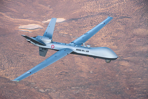
French MQ-9 Reaper. (Photo: DoD press release/UAS Vision)
Military business remains a major source of revenue for the UAV/UAS industry, as demonstrated by the recent award of several contracts to various drone suppliers.
U.S. Naval Air Systems Command recently awarded Insitu a ~$54 million fixed-price contract for four production RQ-21A Blackjack unmanned aircraft systems and eight attrition air vehicles: seven for the Marine Corps and one for the government of Poland. The contract includes ground control stations, launch and recovery equipment, shipboard equipment kits as well as systems engineering and program management support.
U.S. Army Contracting Command recently awarded General Atomics Aeronautical System Inc. (GA-ASI) a Grey Eagle engineering support contract worth ~$11m. Work will be undertaken at the GA-ASI facilities in Poway, CA and will run through to Sept 30, 2019.
GA-ASI has also just won an FMS (Foreign Military Sales) contract worth $123 million for MQ-9 Reaper systems for France – deliveries are expected to be completed by May 2020. An FMS contract is normally how a foreign government procures U.S. government military equipment. The foreign government contracts with a U.S. agency, and the U.S. agency awards a back-to-back contract to the U.S. supplier. In this case, the U.S. contracting authority is the Air Force Life Cycle Management Center at Wright-Patterson Air Force Base.
The U.S. Missile Defense Agency has awarded General Atomics Electromagnetic Systems (GA-EMS), San Diego, California, a contract worth up to ~$134 million to develop, integrate, and flight test an advanced sensor into the MQ-9 UAV. The work will be performed in San Diego, California from August 2018 through October 2021 with realistic flight testing scenarios taking place both within the U.S. and elsewhere.
At the end of August, Boeing won the contest for the U.S. Navy’s unmanned refueling tanker with an $805 million contract award. The award covers the development and manufacturing of an initial four air vehicles. The future MQ-25 Stingray will be the first UAV to operate from U.S. aircraft carriers to refuel and extend the range of several combat aircraft.
L3 Technologies has won a U.S. Army $454M contract to build, deliver and support an electro-optical infrared laser designator for the RQ-7Bv2 tactical UAS. The drone mounted payload will help the Army manage battlespace situational awareness, increase UAS survivability and obtain imagery for target/threat detection.
Counter-UAS Systems
DroneShield out of Australia markets a drone detection and mitigation system, known for its DroneGun, a point-and-shoot device able to disrupt multiple RF frequency bands simultaneously (433MHz, 915MHz, 2.4GHz & 5.8GHz), taking out the communication link to a drone operator — and also GNSS signals when so equipped — up to 1km away.
The full DroneSentry detection system integrates a suite of sensors and countermeasures including radar, optical, RF listening, acoustic, thermal and an RF countermeasure transmitter with greater power/range than the portable DroneGun.
Survey and Mapping
SenseFly recently completed work on a three-year construction project in Northern Ireland to build the new A6 highway. A senseFly eBee Plus drone provided detailed aerial coverage and minimize interruptions with road traffic and ongoing quarry operations.
Adopting an integrated aerial approach enabled the construction contractor to quickly obtain detailed, accurate, professional-grade data, and has helped save time and resources. Reducing the time required in the field and proximity to dangerous quarry sites optimized the mapping task
High-Precision Survey Drone. The TRIUMPH-F1 UAV is built around the JAVAD GNSS TRIUMPH-1M receiver, the company’s high-precision geodetic GNSS receiver with 864 channels to track all current and future GNSS signals.
When used on the ground, the TRIUMPH-F1 can function as a TRIUMPH-1M base or rover. The four motor arms (for eight motors) are detachable. Four screw inserts in the bottom to attach the TRIUMPH-F1 to a pole mount for field use.
The TRIUMPH-F1 features user-friendly mission programming. The four lithium polymer batteries that power the eight propeller motors, arranged in a stacked quad formation.
The TRIUMPH-F1 also has two micro-SD slots for image storage, a SIM card slot, a USB connector for uploading flight plans and downloading collected images, and indicators for satellite tracking and communications. Other indicators are dedicated to flight status and gyro.
Vertical Landing.WingtraOne’s vertical landing technology enables touchdown in confined areas as small as 2 m x 2 m like boats or forest lanes. Combined with a flight range of up to 50 km, this makes large-coverage mapping missions feasible
The vertical-take-off-and landing (VTOL) drone WingtraOne is designed to safeguard its valuable sensors and eliminate wear and tear of the equipment. Instead of broken wings or damaged cameras from belly landings and parachute touchdowns, the WingtraOne lands gently. During the vertical descent, laser sensor data enables the WingtraOne to sense the ground and land safely even on rocky or hilly hilly terrain.
In case of a changing landing environment like a drifting boat or recently parked cars, the landing spot can be adjusted easily.
The WingtraOne works truly autonomously during its entire mission, including take-off and landing. Instead of catapult or hand launches that can cause injuries or damage equipment, the WingtraOne takes off vertically without any human interaction.
Shipping and Logistics
Matternet, based in Switzerland, is testing deliveries using drones under a 3-year program run by the North Carolina Department of Transportation. The NC program is one of 10 authorized by the FAA to evaluate the commercial use of drones.
The objective is to transport small items like blood samples, but initially vials of water will take the ride from a medical office building before landing on a hospital roof. In March, the company was authorized to operate drones over populated areas in Switzerland, carrying samples to hospitals in Lugano.
Items can be securely deposited into the drone station for pick up or retrieved following delivery. A smartphone application is used to authorize pick up and delivery. The item is then scanned for pick up, the station automatically installs the item into the drone for transport, the drone then departs for the assigned destination and on arrival, scanning is required to retrieve the delivered item at the other end.
Conclusion
These examples just skim the surface of an exploding industry which just keeps on keeping on, constantly developing new solutions and applications. High-altitude pseudo satellite drones, drone delivery of goods within minutes of placing an internet order, automated drone facility inspections, power via wireless to keep drones airborne, parachute safety systems for drones….the list goes on and on.
Clearly the UAV/UAS industry has only begun its journey. There are many unexpected places we can look forward to it visiting in coming months and years.
As Hurricane Florence rattles along the coastlines of the Carolinas and Georgia creating havoc, everything that flies is grounded. Right now the hurricane has slowed to a tropical storm, but flooding is extensive and people have died.
As soon as the high winds subside, expect almost all first response groups to put up UAVs to begin damage assessment. Digital images gathered by these drones will assist forward personnel to direct recovery and rescue operations. FEMA and other search and rescue teams, already in place along the track of the storm, have begun to rescue people by boat and are expected to fly drones over other inaccessible areas to find survivors.
And, of course, a significant part of the coverage we will see over the next week or so will come from drone-borne TV cameras and links to network uplink vans. We should also expect drones to be used for significant data gathering to map affected areas for damage to homes and infrastructure — including powerlines, radio and cellphone towers and distribution centers, waterways, roads and railways.
Let’s hope that the lessons learned and experience gathered during the major storms of last year will help everyone operating drones assist in minimizing the time to rescue people and to speed recovery from this latest hurricane. Later, expect the insurance companies to arrive with UAVs to assess damage and verify claims.
Police forces are using drones…
The law enforcement office in Dauphin County, Pennsylvania, has been using a drone for several months. With more than 13 investigations completed, the drone has helped locate one lost individual and has also supported crime-fighting.
Rather than calling out a manned helicopter for assistance, the police are able to get a drone in the air within 20 minutes at much less cost.
FAA regulations govern how Dauphin County law enforcement officials fly their drone, including a waiver granted to allow night-time operations.
…while Colombia is testing drones to destroy coca plants.
Recent growth in Colombian coca cultivation to 516,000 acres during 2012-2017 came as a consequence of the end of a government program to fumigate coca fields. Crop-duster planes spraying glyphosate had previously reduced Colombia’s coca fields from 470,000 to 193,000 acres during 2001-2012, according to U.S. figures.
Meanwhile, U.S overdose deaths from cocaine are continuing to increase, while rebels and drug traffickers have apparently shot down several crop-dusters.
Lawsuits against the use of the chemical glyphosate have also been successful. Over-spray is alleged to have killed other, legal crops, and opponents also cited a recent ruling in California that awarded $289 million in damages to a groundskeeper who said glyphosate-based weed killers had caused his non-Hodgkin lymphoma.
Because of concerns, Columbian police have been testing drones — flying a couple of feet above the plants to mitigate over-spraying of defoliants — to kill coca crops and reduce the supply of cocaine. Apparently, 10 remotely guided drones, each weighing 50 pounds fully loaded, destroyed hundreds of acres of coca in the first phase of tests. Though common in agriculture for the monitoring of crop growth, it’s thought that drones have never before been used to kill illegal crops. The fumigation appears to be about 90% effective to date.
Nevertheless, in Colombia’s drug zones, soldiers will be needed to partition swaths of coca-producing land and to defend operators from angry farmers and drug traffickers. There are also land mines which will need to be overcome from Colombia’s long rebel conflict and which pose a danger to drone operators.
Counter UAS (C-UAS) systems are on the rise.
The Drone Dome system uses Laser, RF and Radar. (Photo: Rafael)
As fast as drone technology is developing, counter UAS (C-UAS) systems are also being put in place to prevent unwanted drones from penetrating the air above sensitive facilities — by detecting and disabling them. There are purportedly more than 60 such C-UAS systems available in the U.S., with more in other countries including China and Russia.
Systems use various technologies for detection — such as radar, laser, optical/IR, RF “sniffer,” and acoustic. Drones can be disabled by RF and GNSS jammers, by spoofing of both the GNSS navigation or the control link, and can be brought down physically by high-power lasers, nets deployed by other drones, collisions by attack drones, by regular or specialized anti-drone gun systems and even by high-pressure water cannons for very close-in defense. Anti-drone systems include detection and take-down dome-based systems and man-portable drone guns.
SpotterRF C-UAV radar. (Photo: UAS Vision)
The UK government has acquired the Drone Dome C-UAS (counter-UAS), manufactured by Rafael, Israel. Detection is provided by an S-band radar (four radars provide all-round coverage), an electro-optical/infrared (EO/IR) surveillance suite, and a wideband RF sensor.
Drones can be disabled by a high-power laser, an RF jammer, or when very close-in by a high-pressure water gun. The UK system is expected to use jamming to bring down drones and doesn’t include the high power “hard-kill” laser option.
Depending on the size of the intruder drone, the radar detection range is around 3.5-10 kilometers, and the radar may also disable a UAV when integrated with the RF jammer. With an active electronically scanned array antenna, the radar is relatively small and light-weight for both fixed and mobile installations.
The DroneGun. (Photo: DroneShield)
Another C-UAV offering, from SpotterRF, claims to solve the problem of requiring multiple radar elements to achieve 360-degree “dome” coverage. The 3D-500 radar enables full “dome-drone” detection from 0 to 90 degrees vertical and 360 degrees horizontal using a single radar with a 500-meter detection radius, yet weighs only 12 pounds.
Latitude, longitude and altitude of intruder targets are measured within a 1-kilometer diameter hemisphere dome. Following radar detection of an unauthorized drone, the system may be augmented by a slew-to-cue optical/IR camera providing a visual display to an operator — a directional RF jammer on a pan/tilt turret can then be activated to take-down the intruder. The system operates automatically to both detect and disable the drone, or manual control is possible to enable initial operator confirmation of the target before take-down is activated.
DroneShield out of Australia markets a drone detection and mitigation system probably best known for its DroneGun. The DroneGun is a point and shoot device able to disrupt multiple RF frequency bands simultaneously (433 MHz, 915 MHz, 2.4 GHz and 5.8 GHz), taking out the communication link to a drone operator — and also GNSS signals when so equipped — up to 1 kilometer away.
The full DroneSentry detection system integrates a suite of sensors and countermeasures including radar, optical, RF listening, acoustic, thermal and an RF countermeasure transmitter with greater power and range than the portable DroneGun.
Another example is the Rex-1 drone gun. Operating in the 2.4 GHz and 5.8 GHz bands, the Rex-1 rifle-like drone-disabling device is a man-portable jammer developed by Russian Kalashnikov Group subsidiary ZALA Aero Group.
https://youtu.be/Px56KtpZ004
Mapping and survey are becoming a major application for drones.
One such example is 3D mapping of a copper mine in only three days using a fixed-wing UAS.
At an altitude of 1,400 meters, the Erdenet open-pit mine in Mongolia extends 5 x 2 kilometers and is more than 200 meters deep in places. Despite strong winds and even some snow in May this year, one UAS quickly captured geospatial data that enabled three-dimensional modeling of the large, complex site.
Site management is expected to use this initial model as a baseline against which future drone-maps will be compared, and to plan future mine operations.
However, extensive preparations over a two-week period were still required, including the installation of 21 ground control points, positioned using GPS RTK measurements. Re-verification of these points was also required from time to time before the survey, due to changes in the mine from ongoing mine operations, including dynamite blasting.
A MAVinci Sirius UAV was used to gather almost 7,000 aerial photographs which were processed through Agrisoft Photoscan Pro software to produce a detailed digital surface model. All the data collected will be used to create various internal views of the mine for continued mining operations. The mine produces about 26 million tons of ore each year, leading to approximately 530,000 tons of copper and 4,500 tons of molybdenum derivatives.
UAVs make medical deliveries.
Some U.S. medical facilities will soon be participating in a Department of Transportation test program to transport medical samples and supplies by UAV — the object being to obtain test results and medical supplies much quicker than at present. Matternet, Zipline and Flytrex — UAV companies already involved in deliveries by drone — will use several different UAVs in the program, which also aims to set up a number of medical distribution centers.
Matternet has been delivering medical supplies by drone in Switzerland, and Flytrex is focusing on food and package deliveries.
Delivery drone in Kasungu, Malawi. (Photo: AFP)
Meanwhile, Zipline and UNICEF have established an “air corridor” in the city of Kasungu in Malawi to test the transport of medical supplies by drone. Rwanda had previously used UAVs to deliver medication in Africa. Other underdeveloped countries without good ground infrastructure could well benefit by using life-saving drone deliveries for urgently needed medication.
Supporting police investigations, mapping of mines, and coca crop destruction all seem to be good examples of newer uses for unmanned air vehicles. And when policing of drone intrusion is required, looks like there are many new options to detect, disable and even take down unwanted drones. I’d say we seem to be making good progress towards better acceptance and that the industry is starting to grow up.
And let’s all hope that the efforts of all first responders in the Carolinas and Georgia continue through the many weeks of recovery from flooding and damage that are still to come, and that people can soon get back into their homes.
As precision guidance, autonomous operations, high-definition geocoded images and high-volume data processing all improve, drone use will continue to increase. OEM receiver manufacturers, sensor suppliers and data-handling companies play key roles in development, and stand to profit thereby.
In particular, use of drones is growing in land management, construction, mining, and farming. An open-pit mine operation can be supported through detailed drone inspection producing high-resolution images. Processed images and data enable keeping tabs on inventory, site changes over time, identifying best areas for further extraction, and monitoring and managing vehicle movement. These tasks required huge amounts of time in the past. Drone overflight and processing tools condense all the effort as well as producing enhanced results to enable faster and clearer decision-making.
What is the biggest challenge for the UAV industry? (Source: GPS World 2018 State of the Industry survey)
Defense. Surveillance and reconnaissance are probably the biggest military drone applications. Carrying payloads that include color video cameras and infrared night vision cameras, more than 19,000 drones are now in the arsenal of the U.S. Army, Air Force, Marines and Special Ops, and more have gone to other nations’ militaries.
Flying at relatively low altitude, with somewhat limited range and powered by a single quiet electric motor, these drones have become essential in gathering forward-situation intelligence.
Other UAV craft provide higher altitude, longer-duration surveillance and reconnaissance over wider range: up to 20 hours, up to 15,000 feet, more than 60 miles afield. Civilian versions of these craft are in development.
Delivery. Respondents to our survey thought delivery will be a breakthrough application for drones. Amazon has several trials running globably. National civil aviation authorities need to move forward with plans to integrate drones into civilian airspace for this initiative to graduate to full-scale operations and achieve their objective of 30 minutes from order to delivery.
What is the killer app for drones? What professional UAV market sector will most powerfully drive adoption and influence new regulations for unmanned aerial vehicles? (Source: GPS World 2018 State of the Industry survey)
Precision Agriculture. One of the most significant applications which seems to be missing from survey responses is agriculture. Both quadcopters and hybrid fixed-wing/copter drones are in widespread use to capture image data overflying crops, and then process the data and build crop analytics. Graphic results point to how crops can be managed to increase yield.
Making this work is a combination of sensor payloads gathering visual, video, lidar, thermal and hyperspectral data; the secret sauce lies in how the data is processed and presented to farmers. Emphasis is placed on exactly how “green” crops appear when inspected by the various sensors. A number of companies offer services for farmers to optimize crop management.
All these areas are show significant drone growth. Let’s not forget facility, transmission line and pipeline inspection — tasks where drones excel at increasing efficiency and decreasing costs.
For more results from the 2018 State of the GNSS Industry, see this page.
Tony Murfin is a GNSS aerospace consultant with several decades experience at leading companies in the GPS/aviation and OEM sectors.
The attack seems to have been mounted by those operating two small six-rotor UAVs similar the DJI Matrice 600 — one was certainly carrying explosives because it was videoed exploding. These drones showed up somewhere near Maduro and disrupted not only the president’s speech, but also broke up the parade with participants running for cover.
One drone seemed to collide with an apartment building, fell to the ground, and then fire broke out in an apartment on the first floor. Firefighters apparently disputed a drone explosion saying that a propane gas tank had exploded inside an apartment, but images show a significant hole blown in the wall below the apartment window.
A number of discrepancies could suggest that the incident was staged, but there were injuries to several in the parade below where the first drone exploded, and the apartment fire was only 400 meters from Maduro’s review stand. The “apartment drone” appeared to behave as if control had been lost, possibly due to anti-drone jamming. Check out pictures, a video and a comprehensive analysis of these events on Bellingcat here.
Zephyr-S launched for flight test. (Photo: Airbus)
Meanwhile, on a more drone-positive note, the Airbus Zephyr S pseudo-satellite, solar-powered UAV achieved a world endurance record flight which was just 3 minutes short of 26 days, eclipsing a previous record of 14 days set by a Zephyr prototype. The ultra-lightweight UAV took off July 11 July and landed Aug. 6. This is likely the longest ever flight by an air-vehicle without refueling (balloons and spacecraft excepted).
The Zephyr S is the first of three such vehicles built by Airbus for the U.K. Joint Forces Command. The Zephyr-S flies around 70,000 feet in the stratosphere, powered solely by sunlight, and is aimed at providing short turn-around, satellite-like communications and observation services for both commercial and military customers. The potential exists to support disaster monitoring of fires, earthquakes, oil spills and the like, and to connect almost everywhere in the world that doesn’t already have established communications.
Following evaluation of the flight test results, further flights are planned from a new base at Wyndham airfield in Western Australia. The aircraft is extremely light and does not have an undercarriage, so it’s hand launched and retrieved under minimal wind conditions.
Joe Lee and paramedics UAV pilot Scott Mcleod confer before a simulated medical rescue scenario. (Image: Kongsberg Geospatial)
Meanwhile, at a deserted airfield near Pembroke, Ontario, Canada, a simulated disaster exercise, led by a Royal Canadian Mounted Police (RCMP) incident commander and supported by personnel from Transport Canada and the National Research Council, was evaluating a new air traffic management system supplied by Kongsberg Geospatial from Ottawa.
Integrating drones with disaster management air traffic is one aspect of the Emergency Operations Airspace Management System (EOAMS), a situational awareness system which provides first responders with situational awareness of the airspace around a disaster scene. The system integrates real-time data from a number of sensors, including 3D airborne radar, ground radar, ADS-B (Automatic Dependent Surveillance — Broadcast) sensors, video and GPS. Real-time information was presented to participants on regular computer displays and through a Microsoft HoloLens “mixed reality” visor.
Drones were flown beyond visual line-of-sight (BVLOS) at up to 2 km away from the airfield while the trial emulated emergency scenarios including a plane crash, a medical emergency, and the protection of a VIP threatened by an approaching, unauthorized drone. Drones were operated by the RCMP and local paramedics.
The EOAMS system displayed ground tracks and the identity of a variety of emergency aircraft, and emergency ground vehicles, and enabled safe flight of UAVs within the same airspace. Non-participating drones in the area of the disaster were also identified as possible threats to police and medical aircraft involved in the recovery efforts.
The RCMP and paramedic pilots flew consumer-model drones including the DJI Mavic to test the system’s capacity to detect small drones. Position outputs from these drones were used to verify the accuracy of the EOAMS-displayed plots. A light aircraft was also used to simulate different airborne assets, including a water bomber.
What was learned in the trials will be useful in further development of future emergency airspace management systems for use by first responders, police services and other government agencies in Canada.
RoboTiCan, an Israeli start-up, has developed a unique way of dealing with unwelcome, unidentified drones that intrude into sensitive airspace. With ground-based radar detecting and tracking an incoming UAV, its large, robust drones use machine vision and artificial intelligence technologies to identify threats and then physically attack them.
This video provides — complete with dramatic accompanying music — an insight into how their “Goshawk” drone engages, attacks and by brute force, disables smaller drones in flight.
At first encounter, the Goshawk octocopter appears to also be disabled by an intentional collision with a small UAV, but subsequent encounters demonstrate how it hones in on, collides with, and disables its target and recovers to attack again.
Compared to bird behavior, especially in the spring when nesting birds use similar tactics to defend their eggs or chicks, it does seem that its mode of operation could be very much like a hawk attacking smaller birds — hence its name.
The Goshawk uses strong, fiber reinforced blades to enhance impact survival, while its smaller drone victims may have plastic props. Overall, it’s large, has multiple blades, seems to use an attack move just before impact, and it recovers well. So control algorithms appear to have been enhanced for collisions and recovery. Its targets seem to immediately lose lift and control before they hurtle towards ground impact.
Not surprisingly, RoboTiCan appears to be positioning its marketing towards military customers, but combining this aggressive take-down capability with a high-quality drone detection/location system might also be a winner for civilian/government drone intrusion defense — Mr. Maduro, take note!
To sum up, we have more bad press for UAVs being used as offensive weapons, interesting progress towards pseudo-satellites as Zephyr-S completes 26 days aloft in the stratosphere, another UTM (UAV Traffic Management) system trial aimed at better air traffic control for disasters, and another way to bring down unwanted drone threats.
This last solution might be a better deterrent for negligent or intentional operators who stray into inadvisable airspace. The potential destruction of the drone might just get some recreational flyers to think twice and perhaps reduce these problems.
After a couple of good hours of progress, we suddenly ran up against a massive “tail-back” — as the English call road-blocks — on the A303. We eventually crawled along further and discovered that all the rubber-neckers were slowing to grab a glimpse of Stonehenge, which you can see on the left, not far from the road. A little further on I saw a sign for Farnborough and thought that its surely around this time of year for that huge aerospace show known as the Farnborough International Airshow. So when I arrived home after almost three email-less weeks, it was not surprising that my inbox was crammed with lots of European aerospace news.
SkyGuardian MQ-9B
General Atomics (GA-ASI) seems to have come out tops in UAV public relations, flying its MQ-9B company-owned SkyGuardian from Grand Forks, North Dakota, to Royal Air Force (RAF) Fairford in Gloucestershire, U.K. on July 10-11 — that’s a 3,760 nautical mile flight in a fraction just over 24 hours. The RAF has operated the MQ-9 Reaper for over 10 years and the RAF configuration of the MQ-9B will apparently be called PROTECTOR RG Mk1. It just so happens that the RAF is celebrating its 100-year anniversary, so GA-ASI took the opportunity to drop in and say hello at a much smaller airshow at Fairford July 13-15.
Then they announced last week at Farnborough that GA-ASI had been selected to provide UAS to the Royal Netherlands Air Force (RNLAF) following consideration by the Ministry of Defence for the Netherlands. Doesn’t sound exactly like a contract yet, but its close enough to say that the Netherlands will take delivery of the Predator B/MQ-9 Reaper Medium Altitude, Long-endurance UAS. They also reminded us that the Spanish Air Force is to take delivery of MQ-9 systems in 2019.
From a SatNav point of view, we might also be interested that the GPS receiver on this UAV has also been upgraded to add Galileo signal capability — a requirement for what seems to be an expanding number of government forces in Europe. No luck yet in securing better information from GA-ASI about this upgrade, but Farnborough has likely kept them hopping, so hopefully more news later.
Zephyr S High Altitude Pseudo-Satellite UAV
Photo: Airbus
Fresh on the heels of taking on the Canadian Bombardier C-Series program (now the Airbus A-220) and closing the first deal with JetBlue for 60 of these aircraft, Airbus has committed to production of the Zephyr S HAPS (High Altitude Pseudo-Satellite) solar–electric, stratospheric UAV.
Zephyr has an 82-ft. wingspan and is designed to operate on solar power in the stratosphere at an altitude of around 13 miles emulating equivalent services provided by satellite. This is well above clouds, the jet stream and the ozone layer, and importantly well away above regular air traffic. Airbus anticipates the drone flying for up to 100 days without landing (its currently record is 14 days) and to travel up to 1,000 nautical miles per day. It weighs 165 pounds, but can support a payload up to five times its own weight.
The Zephyr aircraft began its maiden flight in Arizona a few days ago — the “qualification flight” is being supported by both the U.K. and U.S. governments — and the U.K. Ministry of Defence is the launch customer for Zephyr. The aircraft has so far logged around 1,000 hours total flight time. The test flight will conclude once engineering objectives have been met. Other solar-cell powered aircraft have struggled with landing or take off due to the large wing, light weight and hence stability under wind gusts, so several projects have not progressed past the R&D stage. Airbus & RAF’s commitment to production indicates their faith in the aircraft design.
Staying with the U.K. theme, the Goodwood Estate in Chichester, England — famous for the Goodwood car racing circuit — has recently hosted the Goodwood Festival of Speed, which apparently included drone racing. And at the same time, a Guinness World Record drone speed record was established.
Wingcopter XBR
The Wingcopter XBR is a tilt-rotor UAV with two lift props and two horizontal velocity props, and the drone flown by teenage drone racer Luke Bannister reached an average of 240.6kmph (~150m/h) over a Goodwood 100 meter track, flying over the measured track in both directions to account for wind. This set the world record for the fastest ground speed by a “remote-controlled tilt-rotor aircraft.” A previous record of 179.6 mph has been achieved by a quadcopter drone rather than a tilt-rotor UAV like the Wingcopter, but there is apparently more drag with type of drone, so its classified as a different category of UAV.
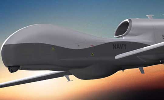
Northrop Grumman Triton High Altitude UAV
Northrop Grumman Triton High Altitude UAV. (Photo: Northrop Grumman)
Meanwhile, Northrop Grumman released a statement at Farnborough on their continuing discussions with Germany towards the sale of its high-altitude Triton MQ-4C unmanned surveillance drone, but apparently a lot of work still remains. In April the U.S. State Dept. authorized the sale of up to four drones worth up to $2.5 billion, and the German government has since been working closely with the US Navy towards a deal.
People may recall the previous cancellation of the “Eurohawk” program back in 2013 — under which Germany had planned to buy a version of Northrop’s Global Hawk drone — after escalating estimated costs for civil certification of the vehicle hit 600 million euros ($702 million) — not a minor task in any way.Subsequently, Northrop and Airbus Defense and Space have teamed up on a new ‘Pegasus’ program, which will add UAVs to Germany’s surveillance capabilities — drones flying autonomously as high as 60,000 feet to gather a wide array of intelligence data.
The German government plans to buy three of the drones, equipped with sensors and a mission system now to be engineered by Airbus. Preparations for certifying equipment to enable the drones to operate in civil airspace are moving more smoothly this time, but with deliveries to only start in 2025. Northrop developed the Triton, a marine-based variant of the Global Hawk, under a U.S. Navy contract awarded in 2008. And Australia last month said it plans to buy six Triton aircraft for maritime patrol, initially expected to cost A$1.4 billion ($1 billion U.S.).
So, lots of military drone stuff this month — not unusual given the nature of the Farnborough U.K. airshow, even though Boeing and Airbus also use the show to one-up each other’s announcements of commercial aircraft contracts and options. Lots of good news for General Atomics, not so much yet for Northrop Grumman, and some light relief with high speed drone records at Goodwood. Back to more North American UAV news hopefully next month.
As the dust from this year’s AUVSI Xponential show, which took place May 1-4 in Denver, begins to settle, we complete the overview we began last month and wrap up our coverage of the show.
Septentrio
Septentrio introduced its AsteRx-i V product series of integrated GNSS/inertial receivers, based on the Septentrio m2 GPS/GLONASS/Galileo/BeiDou/QZSS/SBAS receiver and a high-end VectorNav MEMS IMU. Providing:
AsteRx-i V receiver & IMU. (Photo: Septentrio)
Reliable, accurate IMU-enhanced GNSS positioning down to the cm level
Full attitude — heading pitch and roll
Lightweight, low power <50 grams, typically 1.5 W — suitable for UAV applications
AIM+ interference monitoring and mitigation system
High update rate, low-latency positioning and attitude
Also introduced at the show was the AsteRx SB, a packaged version of the m2 receiver with multiple interfaces and Bluetooth wireless, targeted at machine control and other sensor fusion applications.
GSS9000 Simulator. (Image: Spirent)
Spirent Federal
Spirent offered a demo of its “flagship” GSS9000 simulator at the show — with capability to generate all constellations, all frequencies, plus L-band signals. Kalani Needham (director of sales) also mentioned the company’s sim-MNSA program with Rockwell Collins, aimed at providing support for M-code for the GNSS simulation market.
DJI
Inspire drone. (Image: DJI)
As usual, the DJI booth was extremely busy — with a demo area almost continuously flying each of the most popular DJI drones. What I learnt from my visit was that 70 percent of sales are recreational, and the balance is commercial. With quadcopters for hobbyists, using replaceable parts, auto-flight systems and data links, DJI was virtually the first drone manufacturer to market, and still one of the most successful. The Phantom now carries gimbal-mounted cameras and is finding lots of applications with business, academics and government agencies, including first adopters like the film and TV industry.
Phantom 3 drone. (Image: DJI)
DJI drones have weather resistant bodies, strong blades, swap-out easy-charge batteries, and ADS-B, RTK and heading capabilities. Set-up in the field is simple, with an SDK for lab developers, multi-spectral cameras for applications such as crop growth monitoring, real-time data available through the control uplink and infrared/visible slant-range outputs.
DJI’s approach is to keep ahead of the competition by adding more and more technology over time, and the company clearly has the sales volume to support this strategy.
CyPhy Works
PARC tethered drone system. (Photo: Tony Murfin)
CyPhy Works makes and promotes tethered drones — enabling very long endurance reconnaissance/forward observation/inspection/communications. The company got into this specific drone niche because it found customers who couldn’t live with short duration battery-restricted drone operations.
For ground forces, having a real-time video overview from higher altitude is of great benefit; similarly, they’re of great use for disaster recovery efforts, such as in the aftermath of hurricane Harvey in Texas. And if you add a Wi-Fi transducer working through one of two payload ports on its PARC (persistent aerial reconnaissance and communications) platform, you can also reconnect survivors and provide a comms network for first responders.
Ruggedized Duro receiver. (Image: Swift Navigation)
Swift Navigation
Swift is a relatively new GNSS receiver manufacturer, and its Piksi Multi receiver has a lot to do to catch up technically with the products offered by the predominant players in the market. So its approach is to use rock-bottom pricing for almost all of their offerings. Currently, the Piksi has only GPS L1/L2 and GLONASS L1/L2 plus SBAS, but Galileo and BeiDou are promised for later this year.
The new Swift capability launched at the show is Skylark, a cloud-based, hybrid PPP/RTK network currently testing in around six U.S. areas and planned for national and even worldwide coverage sometime in the future. Skylark is apparently cellular, with a large number of base sites, each equipped with a Swift Duro receiver. With a target subscription price of only $495 per year, this could be a popular GNSS assistance service, provided you use compatible Swift receivers in your application.
Swift is targeting automotive applications, and has a San Jose trial underway with Voyage at a retirement community — residents call for a self-driving taxi using a cell-phone app, and get transport anywhere in the 4,000-strong community. A similar trial at the Villages in Florida (125,000 residents and 750 miles of roads) is also apparently getting underway.
Hemisphere GNSS was also at the show with its line of GNSS receiver solutions for UAVs, Atlas Correction Service and a new V500 Heading/Smart Antenna.
The Vector V500 is an all-in-one multi- frequency, multi-GNSS smart antenna that provides RTK-level position and precise heading. The latest generation of Hemisphere’s heading antennas now appears with an integrated GNSS receiver and a rugged design sealed for the harshest environments — a design that has evolved over many years. It takes a great deal of sweat and tears to get to a reliable weather-hardened product, and Hemisphere has no doubt incorporated a lot of experience into this latest product.
Atlas corrections are derived from public JPL data and are supplied worldwide over Inmarsat L-band satellite transmissions.
Harxon Corporation
D-Helix antenna. (Photo: Harxon)
Harxon’s D-Helix antenna got lots of attention at its booth, as did the OEM frequency-hopping transceiver. The D-Helix antenna supports GPS, Galileo, BeiDou and GLONASS, as well as L-band signal reception. With low wind resistance and ruggedized IP67 protection, this antenna appeared to be very popular at the show for UAV applications.
The frequency-hopping OEM transceiver works over 840-900 MHz and weighs in at only 5 grams. With anti-jamming and wide signal capability, this miniature device is designed for complex data-intensive applications. In full duplex mode, secure data transmissions are possible over long distances with low latency. The popularity for this transceiver at the show might be connected with a recent FAA proposed rule that would require transmission of a drone’s registration ID for remote identification.
More
Other neat products and applications the GPS World team came across at the show included:
Topcon’s B111 multi-constellation GNSS receiver and the Topcon-distributed Sirius Pro fixed-wing UAV and Intel Falcon 8+ quadcopter;
the Rockwell Collins aviation Flight Management System, which is apparently being incorporated into the General Atomics commercial Flight Guardian system;
the senseFly eBee series of drones with automated mapping capability and a BVLOS (beyond visual line of sight) trial in Canada with in-flight data — more on this later.
GPS World will bring you a special UAV supplement later in the year, and we will carry more news and details on selected manufacturers and applications within this exciting and ever-expanding drone industry.
AUVSI Xponential was a big show once again — 8,500 attendees, more than 600 exhibitors, 200 educational sessions and 400 speakers. The show floor was huge as usual, with virtually every kind of UAS product and service imaginable for inspection at small, large and larger booths or display areas.
The morning kick-off presentation on Tuesday was enthusiastic about the coming large-scale adoption of drones and associated robotic technology, with a couple of real-time examples — driverless vehicles at Babcock Ranch in Florida and drone supply deliveries for humanitarian aid in Rwanda.
A view of show floor.
However, there still remain a number of barriers to wide-scale integration of drones into daily life from a regulation perspective, as Steven Bradbury, general counsel of the U.S. Department of Transportation, pointed out — while at the same time also indicating that the Federal Aviation Administration (FAA) has granted hundreds of waivers where the safety case has been adequate for lots of commercial UAS operations.
Most of the major GNSS players were exhibiting at the show, so we focused on gathering their news while also collecting a flavor of the many drone system suppliers in attendance.
U-blox introduced its new ZED-F9P multi-band, multi-constellation chip — with GPS, GLONASS, Galileo and BeiDou signal reception and processing and on-chip multi-band RTK with fast convergence times — promising centimeter-level accuracy and low 85 mA (4x GNSS) power consumption in a 17 mm x 22 mm package.
ZED-F9P signals: coverage added in two stages. Option A – available now. Option B – available Q2/2020.
Initial urban testing in Finland in challenging conditions has indicated RTK performance at 9 cm 94%, with high availability, short convergence times (<10 seconds) and fast reconvergence. This kind of performance is apparently initially targeted at automotive applications — u-blox is a member of the Sapcorda automotive group — and is forecasting samples for this July, with production beginning before the end of this year.
The NovAtel tagline for the show was “Assured PNT,” which matches many U.S. and International agency objectives — this was accompanied by several announcements for both commercial and government agency products and applications.
The integrated E1 package includes NovAtel’s SPAN technology, which optimizes positioning and attitude performance during extended GNSS outages. Both new PwrPak enclosures come with the Interference Toolkit advanced interference detection and mitigation capability.
With most UAVs, the electronics on the airframe can produce a disruptive internal interference environment, and can lead to potential problems for the integration of sensitive GNSS. To help overcome this issue, NovAtel has released the OEM7600 receiver board in an extremely small form factor, enclosed with protective shielding to reduce the effects of emissions from nearby electronics.
The 7600 comes with 555 channels, multi-frequency/constellation positioning; L-band support for TerraStar corrections; serial, USB, CAN and Ethernet interfaces; advanced interference detection and mitigation features; RTK; GLIDE and Steadyline firmware options with 20-g vibration rating and the option to add integrated SPAN GNSS + inertial.
NovAtel also announced Inertial Explorer Express, which provides the same core processing and utilities as Waypoint Inertial Explorer software for applications including unmanned aerial vehicles (UAVs) and smaller projects. Inertial Explorer Express will produce centimeter-level position and attitude solutions for lidar, camera and other sensor data with faster processing times and reduced complexity.
On the government/agency business side of the house, NovAtel has been quite successful with the GAJT antenna, which includes integrated anti-jam technology. GAJT is in use operationally and has been shipped to 16 allied nations around the globe, with the latest success being with the artillery Observation Post Vehicles (OPV) for the Canadian Army.
The NovAtel GAJT-710ML GPS anti-jam antenna.
The Type 26 Frigate of the British Fleet will use NovAtel anti-jam technology. (Photo: BAE Systems)
Canadian OPVs are used on the front-line of combat, so its essential that their location and timing information should not be compromised by enemy jammers. The NovAtel GAJT is readily retrofitted to existing vehicles to provide the necessary jamming defense needed by front-line forces.
Previously, NovAtel also announced the selection of GAJT for the UK fleet of Type 26 Frigates – providing essential anti-jam protection for its onboard navigation system.
MB-Two module by Trimble.
Chris Wheeler and Omar Subra were good hosts when we visited them at the Trimble booth — Chris first made a YouTube video for GPS World (see below) and then gave me some insights into what’s new.
Basically, the OEM line has rolled over new versions of almost all individual receiver boards, with the addition of the BeiDou B3 frequency, capability for RTX PPP (precise point positioning) corrections, the addition of new constellations and inertial integration options.
An updated MB-Two receiver module can be configured for single frequency GPS through to dual frequency GPS, GLONASS, QZSS, Galileo and Beidou, uses RTX PPP and has an improved RTK engine for cm positioning from a base-station, or from over-the-air RTK corrections, or provides relative RTK against a moving base.
A typical Trimble application could include capturing an Insitu ScanEagle UAV in a difficult shipboard multipath environment with integrated GNSS-inertial, UAV navigation and control, UAV payload stabilization, or providing a “truth-system” for autonomous unmanned ground vehicles.
Since last year when Trimble introduced a “cell-phone” software receiver application, one useful application could have involved an insurance company using a “pocket-carried” antenna (with integrated RF) for field incident assessments. The cell-phone software license would be transferable to other assessors in the department, while a few pocket antennas are available for the whole assessment crew. This saves purchasing a whole load of hardware, and being limited to where the functionality can be moved or deployed. Everyone has a cell phone, and the relatively inexpensive antenna/RF can be available to all needing them.
Watch this video to learn about Trimble’s latest products, including its BD990 and BD992 GNSS receiver boards.
Trimble is also ramping up its OEM customer service and repair capabilities to improve turn around for multiple customers and applications in the field. Improved results are beginning to help customers and its OEM business, while increased R&D investment is expected to put new products into the field in the fall.
This year Intel’s emphasis continued to be on how to manage the huge amount of data that high-precision visual and multi-spectral cameras are gathering by UAVs carrying out asset inspections for their customers. The Intel view is that this data is useless to an end-user unless it is interpreted and presented in a format that can be readily understood and used for the purpose it was intended.
Let’s say a company operates 75 drones inspecting installations it owns or operates across several states, and that 50 GB of data is the nominal amount of data each drone collects on each mission. That means that nearly 4 TB of data could be collected daily if all 75 drones operate at once. More likely, over 1 TB daily shows up in a central location — a huge amount of unprocessed data.
In a live demonstration, Intel showed how a typical installation inspection — by a drone taking high-resolution still photos at a remote location – could be collected and managed. Once in an Intel processing environment, the data quickly became visual format in 2D or 3D, and could be accessed remotely by an inspection team, saving significant travel costs and time to actionable results.
Intel also promised to soon exceed its record at the Pyeongchang Winter Olympics for the number of drones flown at once — currently set at 1,218 drones. The company’s next target is for a light display using 1,500 multi-colored drones.
Insitu CEO Esina Alic
Insitu held a media event at the show to announce its ScanEagle-3 drone system. Esina Alic, the new Insitu CEO, led a team who introduced and then unveiled the new commercial-standard ScanEagle variant.
This new variant has grown out of 20 years of experience and 15 years of working with the FAA to enable integration of drones into the U.S. National Airspace System (NAS). The ScanEagle-3 (SE-3) has been rebuilt with the objective of developing a certifiable vehicle with increased payload and endurance capability that is free of any ITAR restrictions — allowing export without restrictions to the rest of the world.
Insitu unveils the ScanEagle-3 is at Xponential 2018.
SE-3 features include:
Significantly increased (x2) payload
Still provides for full integration of all existing payloads
Commercial, non-ITAR product for the global market
Long-endurance platform
Service contracts available
Product release in Q2 2019
Fully compatible with existing launch and recovery systems
Around ~100 lb without payloads
ScanEagle variants were used in emergency response to the California wildfires at Santa Rosa and Medicina, gathering real-time information for fire-line combatants.
ScanEagle helped fight these wildfires using High Accuracy Photogrammetry (HAP) sensors. Military-grade electro-optical (EO) cameras during daylight and infrared (IR) cameras for night-time imaging extended the time available for tracking fire lines. Penetrating smoke or darkness, these UAVs gathered video and still images that were used to create geo-referenced, high-resolution digital fire progression and suppression maps to guide firefighting on the ground.
This small overview of Xponential 2018 attempts to provide a flavor of the breadth of activity we saw at the show last week. A good portion of this has also been captured through short videos published on the GPS World website, along with news articles.
There is more to come, with a report to follow from the show on Septentrio’s new product releases, Spirent’s GNSS simulation demo, DJI’s overview of drone products featured at the show, CyPhy Works tethered drones, Swift’s announcement of its Skylark correction service trials, Hemisphere’s new Vector Smart Heading Antenna, and Harxon’santennas for drones.
A big show to cover, that’s for sure! It’s a good sign that people were perhaps talking more business than in previous years and a sign that the UAS industry is perhaps moving into its next growth phase.
As the days tick down towards the coming AUVSI Xponential convention in Denver April 30 to May 3, new UAV/UAS developments and applications continue to appear, indicating that this industry could be moving from startup into the beginning of a growth phase.
Skycatch and DJI high-precision drones for Komatsu
The construction industry has always been one of the preeminent areas that require medium- to high-precision surveys. And Komatsu has become one of the world’s leaders in machine automation for the construction site.
Now Komatsu has committed to the automation of site surveys using drones, which ultimately appears to be packaged as a turnkey service for construction companies.
Komatsu aims to show up at a site with all the necessary automated construction machinery and a small staff of automation experts. The experts will survey the site using Skycatch drones and manage the construction for the contractor.
Skycatch drones will survey construction sites with existing RTK networks. (Photo: Skycatch)
Skycatch, based in San Francisco, California, has teamed with Komatsu, who has apparently invested financially in the company and purchased around 1,000 Explore1 drones manufactured by DJI from Skycatch.
Explore1 is actually a modified Matrice 100 DJI drone with special additions. A Skycatch onboard computer links GPS real-time kinematic (RTK) high-precision positioning with a gimbal-mounted 20-megapixel high-resolution camera and the flight computer, resulting in centimeter-level geocoded data.
The big deal is that the system uses existing RTK networks.
Komatsu has been using Skycatch systems for more than three years. The Explore1 system is a combination of all the lessons learned on ease of use and time to collect usable data. Explore1 is used to digitize construction sites during planning, construction and completion.
NASCAR drone protection
It’s unfortunate, but nowadays there always seems to be heightened awareness that events where lots of people gather may present ideal opportunities for possible terrorist attacks. And there has been much made of the possibility that UAVs may be included in the next wave of offensive means for terrorists to inflict civilian casualties on the Western world.
So it’s comforting to hear that for the recent NASCAR race in Fort Worth, Texas, a number of security organizations decided to take the precaution of installing drone countermeasures for the event.
DroneGun, part of the DroneShield anti-UAV system. (Photo: DroneShield)
At the Fort Worth race, the Texas State Department of Public Safety, the Denton County Sheriff, the Fort Worth Police Department, the Texas Forest Service and the Texas Rangers used DroneShield anti-drone systems for the protection of the 2018 Monster Energy NASCAR Cup Series at the Texas Motor Speedway on April 8.
DroneSentinel for drone detection, DroneSentry used for integrated detection and defeat, and DroneGun drone interception were all deployed to determine where drones may be operating and to intercept them if required.
This appears to have been the first known live operational use of all three products by U.S. law enforcement to provide “peace of mind in the aerial domain,” as expressed by an officer about the event.
No bees? Just call for a drone
I’m always frustrated by the fruit tree in my backyard — it absolutely insists on flowering in March when there seems to be more high winds than at any other time of the year, so most of its blossoms are blown to the ground. It’s a mature tree, and you would imagine that it should have learned by now.
But when it is calm and warm, only a few butterflies and birds seem to show any interest. I hardly ever see any bees buzzing around and doing their pollinating thing, and so fruit is hard to come by later in the year.
I’ve thought of borrowing my wife’s make-up brush and dabbing my way round the flowers, but the neighbors, or my wife for that matter, might see me and call the cops to get me taken away…
So I was quite interested when I saw that an outfit called DropCopter, based in Corning, California, is setting about pollination using customized drones. DropCopter basically supplements lost bees by flying over flowering fruit trees and dropping pollen on their blossoms using a drone.
This UAS start-up has initiated a drone pollination service which uses automated multi-rotor drones to dust almonds, pistachios and cherries, boosting crops by up to 15 percent! It seems that fruit producers can rent bees when it comes to pollination time, but bee-rental costs have apparently soared recently. Growers may have been paying up to $180 for one hive to be relocated among their fruit trees. These costs have been cutting into margins and raising the price of fruit at the store.
Enter DropCopter to alleviate pollination problems and restore profit margins for the growers.
DropCopter is using some funding provided by GENIUS NY sponsorship to operate its patent-pending pollination system during nighttime over local New York orchards. Bees don’t like the colder night temperatures, so DropCopter can double the pollination time by operating at night while the bees work the day shift.
But where the heck does DropCopter find all the pollen necessary to fill its pollen distribution containers on its drones? The mystery of fruit pollination still puzzles me.
Range of novel UAV applications grows
So, it’s quite a range of interesting drone applications: automated site survey using drones and a suite of Skycatch processing and data-delivery software; anti-drone protection systems becoming commonplace at larger events; and nature getting a helping hand from pollinating drone systems… Who would have ever thought we’d be seeing these novel, innovative drone solutions?
But, then again, who would have ever expected in the pre-2000 timeframe all the applications that GNSS alone has managed to open up?