All three organizations are United Nations agencies and have previously issued similar statements independently. This is the first time they have spoken on this in one voice.
In 2020, ICAO issued a letter to all member states urging them to “strengthen CNS systems resilience and mitigate interference to GNSS.” It contained 13 recommendations resulting from three different work streams within the organization. The last of the recommendations was “… to support the multi-disciplinary development of alternative positioning, navigation and timing (APNT) strategy and solutions to complement the use of GNSS in aviation in coordination with ICAO and airspace users.”
In 201, IMO issued a circular on deliberate GNSS interference.. It called on nations to prevent interfering transmissions coming from their territories, issue warnings about known interference, and consider taking actions to prevent unauthorized interfering transmissions.
This ITU circular urged nations to “address the critical issue” by:
Reinforcing navigation systems’ resilience to interference.
Increasing collaboration between radio regulatory and enforcement authorities.
Reinforcing civil-military coordination to address interference risks associated with RNSS testing and conflict zones.
Increase coordination between aviation, military and radio-regulatory authorities.
Retain essential conventional navigation infrastructure for contingency support in case of RNSS outages and develop mitigation techniques for service loss.
A resolution by ITU’s 2023 World Radiocommunications Conference echoed similar themes. Still, it was criticized because its cautions and prohibitions came with the caveat, stating “…without prejudice to the right of administrations to deny access to the RNSS, for security or defense purposes.”
Many observers opined that there are few reasons for nations to interfere with GNSS other than security or defense concerns, which allows malicious actors to have carte blanche. Furthermore, it was suggested that the resolution might have included language to ensure that security and defense-related disruptions do not extend beyond a nation’s borders or similar provisions.
While no specific events are cited in the statement as motivating its publication, the death on Christmas Day of thirty-nine people aboard an Azerbaijan Airlines flight could have been the reason. The aircraft was approaching a Russian airport during an intentional interference event and was apparently misidentified by Russian forces. It was subsequently damaged by ground fire and crash-landed in Kazakhstan.
The recent joint statement cites, among other international agreements and actions, the ITU Constitution, which says, “All stations, whatever their purpose, must be established and operated in such a manner as not to cause harmful interference to the radio services or communications of other Member States.”
The joint statement concludes with:
Therefore, ITU, ICAO and IMO jointly and urgently call on their respective Member States to:
Protect the RNSS from transmissions that can adversely cause harmful interference, degrading, interrupting, or misleading signals used for civilian and humanitarian purposes.
Reinforce the resilience of the systems that rely on RNSS for navigation, positioning, and timing in relation to this type of interference.
Retain sufficient conventional navigation infrastructure for contingency support in case of RNSS outages and misleading signals, and develop mitigation techniques for loss of services.
Increase collaboration between radio regulatory, civil aviation, maritime, defense and enforcement authorities.
Report cases of harmful interference affecting RNSS to the appropriate telecommunication, aeronautical, and maritime authorities and the ITU Radiocommunications Bureau to enable the monitoring of the situation.
The United Nations and its agencies are collaborative bodies that operate by consensus and through the cooperation of members. As such, they have no ability to enforce standards or compel compliance with recommendations.
Read a roundup of recent products in the GNSS and inertial positioning industry from the March 2025 issue of GPS World magazine.
Surveying and Mapping
Photo: Eos Positioning Systems
New Eco-Friendly Carrying Case For Eos Positioning Systems’ receivers
The Skadi Gold, Skadi 300 and Skadi 200 GNSS receivers will now be shipped in a field-rugged carrying case made entirely from recycled materials. The case is designed to meet the demands of professionals who utilize GNSS technology in challenging environments. Its construction incorporates durable, eco-friendly materials that can withstand various field conditions, from remote wilderness areas to urban construction sites.
A key feature is its composition of 100% post-consumer recycled resin, which significantly reduces waste and promotes environmental sustainability, according to the company. It is specifically engineered to be shock-resistant and weatherproof.The case is provided as a standard inclusion with every purchase of the Skadi Gold, Skadi 300 or Skadi 200 GNSS receivers at no additional cost.
Multibeam Sonar Designed for bathymetric surveying
The Gemini 1200id is built on the same robust platform as the Gemini 720is multibeam sonar. The device features a 120° horizontal field of view, operating at both 720 kHz and 1,200 kHz acoustic frequencies.
The Gemini 1200id incorporates advanced noise reduction technology to significantly improve the attenuation of waterborne electrical noise to enhance imaging performance. An integrated speed-of-sound sensor ensures high positional accuracy of displayed targets, while CHIRP processing technology enhances target separation over extended ranges.
Compatibility with Tritech’s Genesis software package allows users to control multiple Tritech products from a single interface to streamline operations. The company has also made software development kits available for Windows and Linux operating systems to integrate into various platforms. The sonar’s design includes a custom-developed analog front-end solution with fully differential receiver channels, making it ideal for longer-range applications.
HiPer XRa is a GNSS receiver for surveying, mapping and construction applications. It can benefit a wide variety of users, including construction professionals, surveyors, geographic information systems (GIS) professionals, archeologists, engineering firms and more. The HiPer XR supports GPS, GLONASS, Galileo, BeiDou, IRNSS, QZSS and SBAS.
The new receiver has advanced Topcon Integrated Leveling Technology (TILT) compensation, featuring a calibration-free and magnetic interference-immune integrated IMU that provides up to 60° of tilt for precision measurements in challenging positions. It has signal integrity protection, anti-jamming and anti-spoofing capabilities. Through the myTopcon NOW! website, users can access online training materials, firmware updates and additional software resources.
Airborne Lidar System Ideal for coastline and river surveying
CoastalMapper is an airborne bathymetric lidar system for coastline and river surveying. The CoastalMapper can survey coastlines and rivers 250% faster than previous sensor models, according to Leica Geosystems.
It is suitable for various mapping applications, from assessing infrastructure resilience to monitoring river floods and conducting environmental investigations.
It features a high-performance bathymetric lidar module, a Leica TerrainMapper-3 topographic lidar and an imaging sensor, integrated into a compact and lightweight sensor head. This allows the CoastalMapper to capture up to 1 million bathymetric data points and 2 million topographic data points per second while providing high-resolution imagery with a 5-cm ground sampling distance at typical flying heights.
It integrates with Leica Geosystems’ airborne mapping workflows and offers cluster processing capabilities, allowing users to analyze large datasets and reduce the time from data collection to final deliverables. These outputs can include classified point clouds, digital terrain and surface models, and various imaging products.
Surveying Kit Streamlines base station and checkpoint setup
WingtraGROUND, a comprehensive survey kit, streamlines base station and checkpoint setup for on-site post-processing kinematic surveys with the WingtraONE Gen II, a vertical takeoff and landing UAV. The kit combines receivers, checkpoints and tools into a single, portable workflow.
The system integrates hardware components with a Wingtra tablet interface, which can help surveyors confirm correct receiver placement and avoid common errors associated with improper base station setup and inaccurate coordinates.
Wingtra receivers, equipped with Emlid Reach RS3 technology, provide accuracy within 2 cm, meeting high standards for aerial data validation. These receivers can also function independently for terrestrial surveys in real-time kinematic mode, including point collection and stakeout for various applications.
Galileo HAS-Enabled Receiver Offers positioning capabilities with 20 cm accuracy
The Geode GNS3H supports Galileo High Accuracy Service (HAS). It offers positioning capabilities with 20 cm accuracy worldwide without requiring additional infrastructure or subscriptions.
It is built to withstand tough conditions, making it ideal for demanding fieldwork. The device offers various accessories, including the Geode Grip, which combines the Geode with a data collection device of choice into a single handheld solution. A backpack strap kit and survey pole are also available to enhance mobility and flexibility in the field. The GNS3H can be used for surveying, agriculture, construction, forestry, mining and archaeology.
Expanded Mapping Portfolio 3D mapping technologies and more
Topcon Positioning Systems has become an authorized distributor of Pix4D’s photogrammetry software portfolio.
The partnership aims to enhance reality capture solutions across various industries, including surveying, mapping, utilities infrastructure, public safety, forensics, and architecture, engineering and construction.
The agreement streamlines the procurement process for end users by allowing them to access Pix4D’s advanced photogrammetry software solutions through Topcon’s global distribution network.
The GNSS real-time kinematic (RTK) 5 Click — a compact add-on board for high-precision positioning and navigation demands — features the UM980, an all-constellation multifrequency RTK positioning module from Unicore, with the advanced NebulasIV SoC for enhanced performance.
It supports Swift Navigation’s Skylark precise positioning service, multiple GNSS constellations and RTK positioning for centimeter-level accuracy. The board also features JamShield technology for robust performance in challenging environments, USB connectivity for easy configuration and visual status indicators for module status and GNSS signal reception.
It can be used for a variety of applications, including surveying and mapping, precision agriculture, UAVs, autonomous robots and autonomous driving.
Multi-Band GNSS Antenna Can operate in urban environments
Levity Series’ AHP24510 (L1/L2/L-Band) and AHP54510 (L1/L5/L-Band) directional patch antennas are designed to receive signals from GPS, Galileo, GLONASS and BeiDou satellite constellations.
These antennas offer faster and more accurate signal acquisition and lock, specifically in urban environments. The L-Band capability allows compatibility with high-precision GNSS correction services. The multi-band antennas offer integral redundancy to minimize satellite security blind spots and reduce energy consumption due to faster acquisition, requiring less system uptime to save power.
The Levity Series active antennas feature a 45 mm x 45 mm x 10 mm wide-band, dual-stacked patch design with a dual-feed, low noise amplifier, providing 28 dB to 29 dB gain and filtering. They operate with a maximum antenna VSWR of 1-to-1 from 1,207 MHz to 1,603 MHz, and the passive antenna efficiency ranges from 39.93% to 68.51% in the L1 band. These antennas use right-hand circular polarization to mitigate multi-path interference.
The Levity Series includes other multi-band products for high-precision applications, such as the HP24510A and HP54510A stacked-patch passive components, and the TFM.120A surface-mount front-end module, which covers the full multi-band GNSS spectrum including L-band. These antennas are suitable for various applications, including wearables, transportation, robotics, precision agriculture and autonomous vehicles.
The M9PLUS-HCT-A-SMA is an active multi-frequency GNSS antenna designed for high-accuracy applications. It supports L1/L2/L5 GPS, Galileo, Beidou and GLONASS bands, as well as L-band correction services. The antenna utilizes Maxtena’s proprietary Helicore technology, which offers advanced pattern control, polarization purity and efficiency in a compact form factor.
It integrates a pre-filter specifically engineered to mitigate LTE interference. This is crucial for maintaining signal integrity in environments with dense mobile communication networks, where LTE signals can overlap with GNSS frequencies. The pre-filter can effectively block out-of-band LTE signals, reducing intermodulation risks and ensuring clear GNSS signal reception.
The M9PLUS-HCT-A-SMA is built with rugged, IP67 automotive-grade components and includes an integrated SMA connector. It also features an O-ring for enhanced environmental sealing. Weighing only 24 grams, the antenna is ground plane-independent, making it versatile for various installations. It is particularly well-suited for GIS and RTK applications where high accuracy and reliability are crucial.
The MostaTech G321M is a three-axis fiber optic gyroscope (FOG) that offers high-precision navigation and orientation measurement capabilities. This advanced sensor features a data rate of 8 kHz.
Key features of the G321M include an input range of 400° per second, a bias RMS of 1° per hour and an angular random walk of 0.025 °/√h. Additionally, it has a power consumption of 2 W and an initialization time of 1 second. The G321M is designed with a compact form factor, making it suitable for various applications where size and weight are critical factors.
It is ideal for UAVs, robotics, borehole surveys, image stabilization, gimbal stabilization and underwater vehicles.
High-Precision Lidar Designed for precision applications
The TV1 Lite and the TV1 UAV systems are designed for various precision applications, such as mapping and data collection.
The TV1 Lite features TrueNav technology, a Hesai 32-channel laser scanner and a FLIR 5MP global shutter camera with a 90° field of view. It also includes one year of TV1 Lite Annual Processing with support and maintenance.
TV1 offers customization options, allowing users to choose from 26 MP, 45 MP or 61 MP cameras and various Trajectory Correction Service options.
Flight Control System With autopilot functionality
The Prism Supervisor software combines UAV autopilot flight control systems with AI-based observations processed in real time, aiming to enhance UAV operations.
The system provides a programming framework and software development kit for users to create custom mission scenarios. During flight, Prism Supervisor can adapt its autopilot functionality in real time, generating mission segments and flight plans as needed.
The software features a user-friendly graphic interface for mission planning, real-time visualization and execution. It supports Windows, Linux, macOS, iOS and Android.
Remote ID Receiver Enhances airspace awareness and UAV safety
RIDER is designed to enhance situational awareness by providing real-time detection of UAV activity in sensitive areas. It also seeks to provide a clear visibility of surrounding UAV operations to help avoid potential collisions and ensure safer flight experiences.
The device features a built-in industrial chip SIM that provides global coverage through LTE-M and NB-IoT, ensuring connectivity in various environments.
It operates effectively within a temperature range of -20 °C to +60 °C and is rated IP54 for dust and water resistance. The device complies with ASTM F3411-22A and ASD-STAN EN 4709-002 standards, making it suitable for regulatory environments.
The RIDER can detect signals from up to 5 km with its default antennas and up to 10 km when using an optional high-performance antenna. It is equipped with an internal cellular and Bluetooth antenna, along with an integrated GNSS antenna that provides precise positioning and timestamping capabilities. It supports multiple GNSS frequencies and utilizes Bluetooth and Wi-Fi technologies for Remote ID communications.
Streamlined BVLOS Operations For a variety of applications
The Sentaero 6 UAV is designed for advanced over-the-horizon operations beyond visual line of sight (OTH-BVLOS). It features built-in AI and machine learning capabilities for real-time data processing. The system can be used for surveying, mapping, inspection, asset monitoring and more.
Engineered to streamline operations, the Sentaero 6 offers more accurate and up-to-date intelligence on assets. Its onboard computer can processes data mid-flight.
Future developments will include swarm operations, enabling one human to control multiple UAVs simultaneously; fully remote operations and higher safety standards, such as a parachute for urban missions, according to Censys Technologies.
SBG Systems has significantly updated its Ellipse series sensors, incorporating the latest World Magnetic Model (WMM) to enhance accuracy and reliability in navigation applications. This upgrade is available for all Ellipse sensors, including first-generation models.
Designed for unmanned systems such as UAVs, UGVs and marine platforms, the Ellipse series comprises compact, high-precision inertial sensors. These devices feature built-in three-axis magnetometers that measure Earth’s magnetic field, crucial for accurate heading and positioning data.
Updated every five years, the WMM is a globally recognized mathematical representation of Earth’s magnetic field. The latest version, released in December 2024, ensures precise heading and positioning corrections to account for ongoing geomagnetic changes.
NDAA-Compliant UAV Now integrated with ArcGIS Flight
Esri now supports the Astro Max UAV in its ArcGIS Flight application. The Astro Max is the first Blue UAS-cleared and NDAA-compliant UAV to integrate with Esri’s platform.
The Astro Max, developed by Esri partner Freefly Systems, adheres to the security and performance standards set by the National Defense Authorization Act and the Defense Innovation Unit’s Blue UAS initiative. This industrial UAV is designed to enhance the capabilities of government and enterprise users utilizing ArcGIS Flight.
Autonomous Swarm Control Controls various autonomous platforms
The Autonomous Multi-Domain Operations Resiliency Platform for Heterogeneous Unmanned Swarms (AMORPHOUS) software features a single-user interface to operate thousands of autonomous assets simultaneously. Designed with an open architecture, this software enables the U.S. and allied militaries to control a mix of uncrewed platforms, payloads and systems.
AMORPHOUS includes an intuitive and distributed command-and-control interface to give operators the flexibility to conduct a wider array of intricate military missions. This collaborative autonomy at scale will provide warfighters with a decisive overmatch capability.
L3Harris is developing prototypes using the AMORPHOUS architecture on contracts for the U.S. Army and the Defense Innovation Unit. AMORPHOUS has demonstrated flexibility and interoperability by controlling multiple, separate assets across multiple vehicle types operating in different domains during government-managed tests.
AMORPHOUS supports decentralized decision-making, which enables individual, uncrewed assets to perform tasks autonomously and make real-time tactical decisions inside the network.
Advanced Counter-UAV Radar Multi-console radar control and display system
Cambridge Pixel has developed a radar control and display system for Weibel Scientific’s XENTA surveillance radar, which is designed for modern air defense and counter-unmanned aerial systems (C-UAS) applications.
The XENTA radar includes 3D target tracking, continuous target illumination and synthetic receiver beamforming. It is available in two configurations: the XENTA-M for short-range air defense and the XENTA-C for C-UAS operations.
The system is designed to work seamlessly with third-party command-and-control systems, enhancing operational efficiency.
Cambridge Pixel’s library of radar processing software allows users to develop a tailored radar controller specific to the XENTA radar’s requirements. Enhancements were made to existing functionalities, such as improved MIL-STD-2525 overlay graphics and support for dual-redundant operator consoles.
The XENTA radar system can detect small UAVs at distances exceeding 7 km and classify them beyond 5 km. This capability makes it suitable for various applications, including airport security, border control, critical infrastructure protection and event security.
The Pelican 2 agricultural spray UAV has an expanded 300-liter payload capacity and can cover up to 5.3 ha/hr.
It incorporates several technological enhancements designed to meet the demands of agriculture applications. The aircraft features an upgraded four-motor electric propulsion system, a wider 18-m spray swath and advanced lidar and radar systems for fully autonomous day-and-night spraying. These improvements aim to increase efficiency and precision in aerial application while reducing operational costs for farmers.
The Pelican 2’s airframe and structural components are constructed from carbon fiber composites, corrosion-resistant metallic components and 3D-printed assemblies.
Xona Space Systems and Trimble have collaborated to integrate Trimble correction services with Xona’s PULSAR high-performance navigation service.
Initial satellite launches are expected in late 2026 with service starting in 2027 through the PULSAR satellite network, enabling secure, high-precision positioning for applications ranging from geospatial to low-power mass mobile and IoT. In support of this new and developing collaboration, Xona has received an investment from Trimble Ventures.
Xona PULSAR, powered by Xona’s planned network of small satellites in low-Earth orbit (LEO), is being developed to deliver robust and secure high-precision positioning and navigation services directly to current GNSS hardware. The PULSAR service, which will include high precision correction services through this collaboration, has the potential to provide scalable, cost-effective solutions for industries with demanding positioning and navigation requirements, such as civil construction, surveying and mapping, and automotive and IoT applications. Xona’s signals are also expected to enable operations inside low-rise buildings, as well as improve resistance to jamming and interference compared to current GNSS capabilities.
Precision positioning solutions from LEO constellations are intended to provide new enhanced capabilities along with high levels of uptime to meet the rapidly evolving needs of industries around the world. Including Trimble correction services with Xona PULSAR is expected to enhance the reliability of Trimble correction services delivery, which is crucial for users in areas without reliable cell coverage, limited sky visibility environments, including high-latitude regions and other challenging geographies.
Project Manager Positioning, Navigation and Timing’s Mounted PNT product office has received full-rate production approval for the Mounted Assured Positioning, Navigation and Timing System Generation II (MAPS Gen II), a key Army modernization initiative, from the Program Executive Office Intelligence, Electronic Warfare and Sensors. This approval allows the Mounted PNT office, in collaboration with Collins Aerospace, to begin full-rate production and fielding of MAPS Gen II as it moves toward initial operating capability.
MAPS Gen II provides GPS anti-spoofing and anti-jamming capabilities through sensor fusion algorithms and non-radio frequency sensors. These features enable mounted soldiers to operate in environments where military GPS is denied or degraded. The system supports U.S. Army forces by allowing them to move, shoot and communicate effectively while distributing PNT data to multiple users on a single platform. This is designed to eliminate redundant GPS receivers and antennas.
The system includes anti-jamming and anti-spoofing protection, a sensor fusion processor that integrates multiple PNT sources, and open architectures such as APSN and VICTORY. It outputs PNT data through multiple distribution standards, ensuring compatibility across platforms.
For the fourth consecutive year, Jammertest will take place in Bleik on Andøya, Norway, with applications now open until March 15, 2025. This event serves as a critical platform for industry and equipment manufacturers to test their systems against jamming and spoofing attacks, identify vulnerabilities and develop more resilient solutions. It attracts participants from diverse sectors, including the global automotive and security industries, telecommunications, academia and government authorities.
The event’s importance is underscored by the growing reliance of civilian services on satellite communications. Essential societal functions — such as transportation, emergency services, electronic communication, financial systems, and power supply — depend on accurate satellite-based positioning and timing. However, incidents of signal interference have highlighted vulnerabilities. For example, rescue helicopters in Norway have faced landing difficulties due to disrupted signals, and airports have been affected by illegal jammers. Airlines have also reported spoofing activity. According to the Norwegian Communications Authority, GNSS interference is an escalating concern that demands ongoing testing and innovation.
Jamming refers to the deliberate disruption of signals such as GPS or radio frequencies, while spoofing involves transmitting false signals to deceive receivers. Both tactics pose significant risks to civilian infrastructure. The Jammertest provides a unique opportunity for participants to evaluate their equipment under real-world conditions at Andøya’s remote location. This setting allows for “open air” testing without risking disruptions to civilian infrastructure or air traffic control systems — an advantage not feasible in densely populated areas.
Andøya’s geography makes it an ideal site for these trials. Surrounded by mountains and isolated from major population centers, it enables high-power signal testing while minimizing societal impact. Participants receive direct feedback on how their systems perform under controlled interference scenarios.
About Jammertest
Jammertest is recognized as the world’s largest open arena for testing resilience against jamming and spoofing attacks. It is organized in collaboration with several Norwegian authorities, including the Norwegian Public Roads Administration, Norwegian Communications Authority, Norwegian Defense Research Establishment, Norwegian Metrology Service, Norwegian Space Agency, Norwegian Mapping Authority, and Testnor.
This year’s event is scheduled from Sept. 15-19, 2025.
Astranis has completed a critical demonstration for the U.S. Space Force’s Resilient GPS (R-GPS) program, showcasing its ability to transmit core GPS waveforms using software-defined radio hardware. Conducted ahead of schedule and within budget, the demonstration highlights Astranis’ ability to adapt its flight-heritage high-orbit satellite hardware to meet new resilience requirements for the Space Force.
The test took place at Astranis’ headquarters in San Francisco, California, using a flight-like software-defined radio and positioning, navigation and timing algorithms provided by Xona Space Systems, a partner and subcontractor for the R-GPS program. Astranis transmitted a GPS Course Acquisition (C/A) navigation signal through its resilient GPS payload and demonstrated signal acquisition and recovery of Legacy Navigation messages with an off-the-shelf GPS receiver. According to Astranis, this validated that its resilient GPS design, Nexus, complies with GPS specifications “out of the box,” ensuring compatibility with existing user equipment without requiring costly upgrades.
Astranis was selected in September 2024 as one of four contractors to design next-generation resilient GPS satellites under the Space Force’s initiative. The company received its Authority to Proceed on Sept. 19, 2024, and has since exceeded program objectives ahead of schedule. The R-GPS program aims to augment the existing GPS constellation with smaller, cost-effective satellites to enhance resilience against threats such as jamming or spoofing.
Astranis is advancing its satellite design in preparation for the Space Force’s goal of launching the first eight R-GPS satellites by 2028. The company’s approach leverages its MicroGEO satellite design and software-defined radio technology to deliver resilient capabilities while maintaining compatibility with legacy equipment.
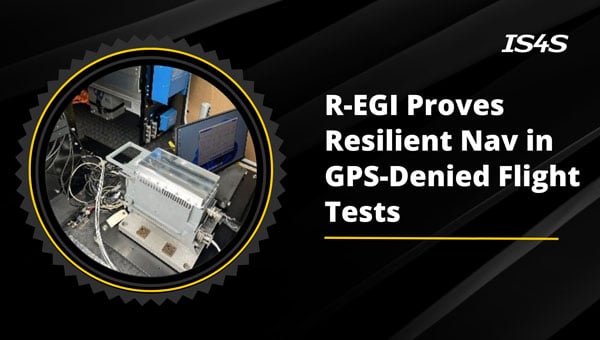
The Air Force Life Cycle Management Center’s Positioning, Navigation and Timing (PNT) Program Office, Integrated Solutions for Systems (IS4S) and AEVEX Aerospace have completed flight tests for the Resilient-Embedded GPS/INS (R-EGI) Modular Open Systems Architecture (MOSA). The tests demonstrated R-EGI’s ability to integrate third-party alternative PNT solutions to ensure reliable navigation in GPS-denied environments.
This achievement marks a step forward in developing R-EGI, demonstrating its ability to integrate a “plug & play” third-party alternative PNT capability that ensures reliable navigation in GPS-denied environments.
“This flight test represents a pivotal moment in the evolution of resilient PNT systems,” said Jeff Hebert, senior scientist for PNT at the Air Force. “The rapid and cost-effective integration of third-party PNT solutions into Department of Defense weapons systems is precisely why R-EGI and its open architecture were envisioned.”
The R-EGI system’s open MOSA design enables seamless integration of government and third-party applications to address emerging navigation threats. Its Mission Capability Navigation (MCNAV) component allows for seamless integration of external alternative PNT solutions under challenging conditions.
During six test flights on a Special Operations Command C-146A Cougar aircraft, R-EGI operated successfully in GPS-denied environments, validating the system’s resilience and capacity for real-time adaptability. Using AEVEX Aerospace’s LynxVBN vision-based navigation system, it maintained approximately 10 m of positioning accuracy for up to 2.5 hours. Notably, LynxVBN was integrated into R-EGI’s MCNAV software in just one hour, underscoring the system’s adaptability. As the algorithms continue to improve and evolve, R-EGI’s alternative PNT accuracy will only become more refined, enhancing its capability to perform in increasingly complex and challenging environments, according to the company.
“After demonstrating that the R-EGI architecture could integrate multiple GPS receiver vendors, and then three months later, witnessing its performance, from the Cougar-provided live-stream data feed, in real-time GPS-denied flight scenarios was the most impressive showcase we’ve seen in the program’s history,” said Major Bernard Mutz, project manager for R-EGI
The successful integration of alternative PNT technologies into R-EGI seeks to enhance the system’s GPS resilience. Also, it sets a new benchmark for reliable, flexible navigation in GPS-degraded environments, said Mikel Miller, senior vice president for PNT at IS4S.
AgEagle Aerial Systems has introduced version 2.1.0 of its eBee VISION application software, designed to significantly enhance UAV capabilities. The update expands the system’s functionality, introducing circular and grid mapping features. These new mapping capabilities allow users to generate 2D or 3D maps using external post-processing software for more comprehensive geospatial data.
eBee VISION 2.1.0 can continue missions in GNSS-denied environments and allows manual deactivation of GNSS to prevent jamming or spoofing. It implements the STANAG 4609 standard, the official format for motion imagery exchange within the NATO nations. This involves embedding UAV position and camera information into the videos recorded by the UAV and those broadcasted by the Ground Control Station. Its inclusion in the system enhances interoperability with third-party applications, which is key for military-grade UAVs.
Another improvement in the software update is the enhanced control over the Silent Tactical Landing feature. Users can now manually adjust the landing position on the map, with the system providing range estimates to inform operators of the UAV’s reach. This functionality offers greater flexibility in mission planning and execution, particularly in tactical scenarios requiring precise landing control.
When we discuss the security of GNSS/PNT systems, we nearly always focus on interference — i.e., meaconing, intrusion, jamming or spoofing. However, GNSS/PNT systems are embedded in systems of systems that also offer many other opportunities for cyberattacks.
What should we do about it?
Ellen Hall
“The key is platform architecture, specifically ensuring robust spatial and temporal partitioning between safety-critical and non-safety-critical functions. Safety-critical functions, such as navigation and autopilot, must be isolated from non-safety-critical functions, such as mission compute, where artificial intelligence typically operates. This partitioning minimizes the scope and effort required to produce design assurance artifacts for airworthiness certification. Additionally, it enhances security by reducing potential attack vectors through the isolation of safety-critical and mission-critical capabilities.”
— Ellen Hall Imminent Federal
Mitch Narins
“An old mariner’s proverb is: ‘The prudent mariner never relies solely on any single aid to navigation.’ A more recent statement offers: ‘With so many pieces of sophisticated electronic equipment at our beck and call it would seem some are lulled into complacency and are ignoring basic seamanship.’ In September 2018, the U.S. Naval Institute published an article titled, ‘Professional Mariners Cannot Rely on Electronics Alone.’ The recent news that the U.S. ITAR restrictions on multi-element antenna arrays will be lifted (thanks to many in our community who have lobbied hard for this for many, many years) is excellent news. It will help and was a necessary change — but it is not sufficient. It certainly does not remove the need to pursue complementary, PNT solutions that will ensure the safety, security, and economic well-being of PNT users and their PNT-dependent systems worldwide. From a basic systems engineering perspective, incorporating multiple solutions with independent failure mechanisms is ultimately the end product that we in the PNT community should all be seeking. We must not forget, however, a key element of many of these systems: the human in the loop, who, if continually provided the opportunity to train in PNT-challenged environments, often can be the ultimate system safety element. This will require the design of our PNT services to ensure that the human factors designed into these systems include sufficient information for the human component to understand an off-normal situation and have the training and skills to take the appropriate corrective actions.”
The Air Force Research Laboratory selected Zephr.xyz — a company specializing in augmented position, navigation and timing technologies — to receive a $1.74 million Small Business Innovation Research Direct-to-Phase II contract. Under the contract, Zephr.xyz aims to develop a system for real-time detection of GPS/GNSS jamming and spoofing in contested environments while also geolocating the sources of these attacks.
The company’s Networked GNSS technology, which converts standard mobile phones into a high-fidelity GNSS receiver network, will undergo extensive testing in Ukraine and various U.S. military exercises. Following these trials, the system is set to be integrated with the Department of Defense’s Tactical Assault Kit and the Department of Homeland Security’s Team Awareness Kit.
Zephr.xyz has conducted field research in conflict zones in Ukraine and Israel, revealing limitations in current GNSS interference detection and localization techniques. The company’s solution aims to address these challenges by leveraging distributed mobile devices to create a decentralized sensor network. This network collects raw GNSS measurements to identify electronic attack indicators, which are processed in real time for detection and classification.
The technology also aims to enhance positioning accuracy on TAK devices by integrating GNSS measurements from multiple devices with Position, Velocity, Attitude and Timing data. Zephr.xyz plans to make its detection and classification capabilities available as a software development kit, enabling mobile applications to alert users and improve positioning accuracy in electronic warfare scenarios.
For years, aviation safety organizations and maritime authorities have relied on ADS-B-based reports to assess GNSS interference. Services such as gpsjam.org, spoofing.skai-data-services.com and flightradar24 have provided valuable insights into interference patterns at high altitudes. However, this data tells only part of the story. Ground-based infrastructure — ports, telecommunications networks, and precision navigation systems — operate in a vastly different signal environment. High-altitude detections cannot reliably indicate the presence or impact of interference at sea level.
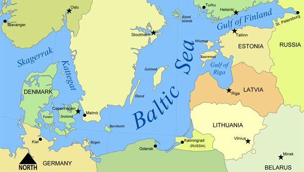
To address this critical knowledge gap, GPSPATRON and Gdynia Maritime University have conducted a six-month study on GNSS interference in the Baltic Sea. Using terrestrial GNSS monitoring technology, the project examined the frequency, duration and characteristics of interference events affecting maritime navigation and other critical applications.
Data collection and analysis
At the core of this study is a terrestrial GNSS monitoring system developed by GPSPATRON, designed to capture and analyze signal disruptions in real-time. Installed at the Faculty of Navigation at Gdynia Maritime University, this system continuously recorded GNSS signal integrity and transmitted the collected data to a cloud-based analytics platform. This platform facilitated the automated detection, classification and visualization of GNSS interference events, providing a comprehensive understanding of interference patterns and their potential impact on maritime navigation. The results paint a stark picture of persistent and evolving interference patterns in the Baltic region. More than 84 hours of GNSS interference were recorded, with October exhibiting the highest activity. Two primary interference types were identified: multi-constellation jamming, prevalent in the summer months, and multi-tone interference, which emerged in October.
Key findings
Persistent GNSS Interference: A total of 84 hours of GNSS interference was detected, indicating continuous disruptions in the region. Most incidents were caused by jamming rather than spoofing.
October saw peak interference levels: The month recorded six major jamming events totaling 29 hours, showing an escalation in disruption frequency and severity.
Maritime sources of interference suspected: Signal pattern analysis confirms that the source was mobile, reinforcing the likelihood of a single ship or multiple vessels operating the same advanced jamming technology.
High-Precision Jamming Signatures: The interference signals detected exhibit structured modulation patterns and frequency agility, suggesting the use of highly sophisticated jamming techniques. These characteristics indicate high-grade equipment, potentially of military origin, with capabilities far exceeding those of common commercial jammers. The consistency and precision of these disruptions highlight the need for further investigation into the source and intent behind these operations.
No link to ADS-B reports: Despite extensive ground-level interference, ADS-B-based monitoring systems failed to register corresponding events, highlighting their limitations in assessing terrestrial threats.
Long-duration disruptions: Some interference events lasted more than seven hours, significantly affecting GNSS-dependent operations in maritime navigation and port activities.
Implications for maritime and critical infrastructure
The findings of this study expose a critical gap in current GNSS monitoring methods. High-altitude interference reports, primarily based on ADS-B data, fail to capture the real impact of jamming and spoofing at ground level. Maritime operations, port logistics, and other critical infrastructure remain vulnerable due to this oversight.
Ports, telecommunications providers, and emergency services rely heavily on GNSS for navigation, timing synchronization, and security. Without precise ground-level monitoring, disruptions can go unnoticed, leading to cascading failures across multiple sectors.
A major concern is the false sense of security created by ADS-B-based detection systems. While these services report daily interference incidents, they do not reflect the full extent of ground-based GNSS disruptions. As a result, infrastructure operators may underestimate the risk, assuming that existing monitoring solutions provide adequate coverage. This misconception is dangerous, as it masks the severity of interference threats that remain undetected in high-altitude datasets.
To mitigate these risks, there is an urgent need for a dedicated GNSS interference monitoring network along the Baltic Sea coast. Such a network would provide real-time, localized data to accurately assess threats, detect interference sources, and enhance infrastructure resilience against GNSS disruptions.
Conclusion
This study confirms that GNSS interference is a persistent issue at sea level, posing a serious threat to critical infrastructure, which predominantly operates at ground level. Prolonged interference events were recorded, some lasting several hours, leading to significant degradation in positioning and timing accuracy. This disruption directly impacts maritime operations, telecommunications, emergency response, and other sectors reliant on GNSS services.
High-altitude interference detection alone is insufficient, as it fails to capture threats affecting ground-level operations. Relying solely on ADS-B-based reports creates a false sense of security, leaving critical systems vulnerable to undetected risks.
To mitigate these risks, there is a clear need for a dedicated ground-based GNSS interference monitoring network. Such a system would provide real-time detection, precise geolocation of interference sources, and timely countermeasures to protect infrastructure.
GPSPATRON and Gdynia Maritime University urge regulatory bodies to take proactive steps toward enhancing GNSS interference detection and mitigation. Without coordinated action, vulnerabilities in national infrastructure will continue to escalate, leading to potentially severe operational and security consequences.