SpaceWERX, the innovation arm of the U.S. Space Force, has selected Xairos Systems Inc. for a $1.9 million Direct-to-Phase II contract to develop a fusion positioning, navigation and timing (PNT) system. This project aims to integrate quantum and optical synchronization of clock ensembles to address critical challenges faced by the Department of the Air Force (DAF).
Xairos Systems is collaborating with Luminous Cyber Corporation and Eritek on this initiative. The team has recently completed a Preliminary Design Review. The Air Force Research Laboratory (AFRL) shared that the collaboration is part of a broader effort by the AFRL and SpaceWERX to streamline the Small Business Innovation Research and Small Business Technology Transfer processes.
AFRL and SpaceWERX seek to streamline the Small Business Innovation Research (SBIR) and Small Business Technology Transfer (STTR) process through faster proposal-to-award timelines, changing the pool of potential applicants by expanding opportunities to small businesses and eliminating bureaucratic overhead by continually implementing process improvement changes in contract execution, according to AFRL.
In 2018, the DAF launched the Open Topic SBIR/STTR program to broaden its funding for innovations. As part of this initiative, Xairos is developing innovative technologies that enhance the national defense of the United States.
The U.S. Navy has selected Northrop Grumman to advance its airborne navigation capabilities by integrating Northrop Grumman’s LN-251M, the upgrade of the LN-251 inertial navigation system (INS)/GPS. This new system incorporates M-Code technology, which provides an encrypted, military-specific signal with improved resistance to jamming, offering better protection against potential threats.
According to the company, the LN-251M represents a significant advancement in naval aircraft navigation, being the first M-Code navigation system designed for this purpose. The M-code technology offers increased robustness against GPS signal degradation, which allows pilots to operate more effectively in areas where GPS signals may be compromised or unavailable.
The LN-251 series is designed to integrate seamlessly with existing aircraft navigation systems and is compatible with future software and GPS modernization upgrades.
NATO has selected SandboxAQ as one of approximately 70 companies to participate in the 2025 Defense Innovation Accelerator for the North Atlantic (DIANA) cohort. The selection process involved more than 2,600 submissions from 32 NATO countries. DIANA, established by NATO in 2023, aims to address complex societal challenges by bringing together innovative companies developing dual-use technologies for both commercial and defense applications.
SandboxAQ will join the cohort’s Sensing & Surveillance group, focusing on the development of its AQNav magnetic navigation system. AQNav is designed to provide a secure navigation alternative that does not rely on GNSS, making it resilient against jamming and spoofing. The system utilizes SandboxAQ’s proprietary Large Quantitative Models (LQMs), quantum sensors, and the Earth’s crustal magnetic field to offer an all-weather, day and night, terrain-agnostic navigation solution for military and commercial applications.
The AQNav system has undergone extensive testing, including more than 200 hours of flight tests with the U.S. Air Force, involving more than 40 sorties across various geographies and aircraft types1. In July 2024, AQNav demonstrated its capability to serve as a primary navigation source and showed potential for scalability across similar aircraft types without individual calibration.
As part of the DIANA program, SandboxAQ will receive resources, insights and developmental support to advance AQNav’s capabilities. The company will also have opportunities to test the system in specialized environments, leveraging DIANA’s network of experts in technology, commercial development and defense.
The Directorate of Defense Trade Controls (DDTC) has changed the regulatory status of Controlled Reception Pattern Antennas (CRPAs) for position, navigation and timing (PNT). Starting September 2025, CRPAs will no longer be subject to the International Traffic in Arms Regulations (ITAR). Instead, they will be reclassified under the less restrictive Export Administration Regulations (EAR) list, which is under the jurisdiction of the Department of Commerce.
The rule, in part, removes items from the U.S. Munitions List (USML) “that no longer warrant inclusion.” According to the rule, “certain anti-jam antennas no longer provide a critical military advantage, with increasing commercial utilization applicable to civil GPS resiliency.” By removing CRPAs for PNT, “the Department intends to facilitate civil global navigation system resiliency.”
The recent regulatory change is expected to significantly impact several industries, including airlines, autonomous vehicles, UAVs and critical infrastructure applications, which can benefit from the increased availability of CRPAs. Additionally, this change may open the U.S. market for CRPA manufacturing, potentially resulting in swift technological advancements and lower costs.
The importance of CRPAs lies in their ability to protect GNSS receivers from interference and jamming. GNSS signals are inherently weak and susceptible to both deliberate and unintentional interference. CRPAs work by adjusting their reception pattern to create nulls in the direction of interfering signals while maintaining reception from desired satellite signals. This adaptive beam steering capability allows CRPAs to effectively eliminate signals from particular directions while preserving signals from others, making them a powerful tool in ensuring the reliability of GNSS-dependent systems.
ANELLO Photonics has received a Phase I Small Business Innovation Research (SBIR) contract from the U.S. Navy. The six-month contract will allow ANELLO to demonstrate its optical gyroscope and sensor fusion technologies for navigation without relying on GPS.
Under the contract, the U.S. Navy will evaluate ANELLO’s integrated photonics technology and AI-based sensor fusion engine. These technologies aim to maintain accurate navigation in challenging environments where GPS signals may be unavailable or compromised.
ANELLO Photonics’ technology can be used for construction, agriculture, transportation, robotics, unmanned vehicles and national security. The company’s focus on navigation solutions for GPS-challenged scenarios aligns with growing needs in both military and civilian domains for reliable positioning systems in diverse environments.
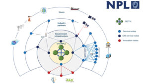
Saying the government must focus on “delivering an operational resilient positioning, navigation and timing (PNT) system for the United Kingdom as soon as we can,” the British Science Minister, Lord Patrick Vallance, announced several initiatives in his opening remarks to the Royal Institute of Navigation’s UK PNT Leadership Seminar on Nov. 20, 2024.
Among them was a funding increase for the National Physical Laboratory’s National Time Centre (NTC) project from £30 million ($38 million) to £62.7 million ($79 million) and a plan to have NTC and the first of the nation’s new eLoran towers at initial operating capability (IOC) by January of 2027.
Plans for all efforts beyond next year were necessarily “subject to spending review.”
Still, seminar attendees were gratified to hear the minister’s endorsement of the 10-point PNT policy framework published by the previous administration in 2023 and his commitment to operationalizing it with implemented systems.
Shabana Haque, Ph.D., head of the United Kingdom’s National PNT Office, also addressed the seminar and elaborated on the government’s actions to date and plans moving forward. She also discussed efforts toward developing quantum technologies and how all the capabilities would be incorporated into a coherent architecture.
Photo: RNT Foundation
Clocks
The United Kingdom recognizes time and timing as the most fundamental component of the PNT utility. Its NTC R&D program, run by the National Physical Laboratory (NPL), has been up and running since 2019. Its primary objective is to create “…a resilient UK national time infrastructure through the building and linking of a new atomic clock network distributed geographically in secure locations.”
Five years later, that program is coming to an end. Plans are in the works for the next phase of the NTC program, which includes developing a national timing infrastructure and supporting a new timing ecosystem — one that includes two-way satellite-time transfer (TWSTT), eLoran and the country’s legacy MSF radio time service. The industry will have a valuable role in the architecture of time distribution and providing value-added services while accessing highly resilient and well-authenticated core government time infrastructure.
As a result of NTC work to date, traceable time and frequency signals can now be accessed by industry and academia from three NPL nodes dispersed across the United Kingdom. They are at the University of Strathclyde in Scotland, the University of Cranfield in the Midlands and the University of Surrey in the south.
eLoran
eLoran also features prominently in the United Kingdom’s PNT plans. Britain operated Loran-C as part of the Northern European network until the end of 2015. For the last year of that, differential stations were deployed along the United Kingdom’s eastern coast and maritime operations based on eLoran were authorized.
On Jan. 1, 2015, and despite British pleas to the contrary, other northern European nations terminated Loran broadcasts in favor of Galileo. The United Kingdom has continued to operate its single eLoran transmitter as a national time signal. Plans call for additional transmitters to enable eLoran navigation across the nation and its adjacent waters within the next two years.
UrsaNav Loran monitor on Nautel equipment. (Photo: RNT Foundation)
The UK government has been working with several partners to advance its understanding and plan for the implementation of an eLoran capability. Haque highlighted work with the European Space Agency’s NAVISP program, resulting in the British company Roke developing an eLoran antenna for handheld devices.
She also discussed integrating the NTC’s clock and fiber network with eLoran signals and developing GNSS/eLoran receivers.
Many were particularly interested in an “eLoran Effectiveness Report” that the government commissioned and received from the General Lighthouse Authority’s Research and Development (GRAD) team. GRAD has extensive experience with the technology, having operated and evaluated the differential eLoran system along Great Britain’s east coast.
In a related move that helped signal the United Kingdom’s commitment to the technology, the Ministry of Defence issued a Request for Information (RFI) in September 2024 about a deployable eLoran capability. The RFI indicated that the document was a prelude to an acquisition.
Quantum research
The United Kingdom has invested more than £1 billion ($1.3 billion) into quantum research, which has the potential to contribute to PNT with better timekeeping and inertial and gravimetric sensing.
One aim of the quantum research program is to develop “…new navigation and timing systems to provide resilience and improved accuracy in the event of the denial of satellite systems.” A specific goal is to deploy quantum navigation systems, including clocks, on aircraft by 2030.
The program began in 2014 and has seen a significant increase in 2024 with the establishment of five quantum hubs nationwide. The hub at the University of Glasgow focuses on resilient PNT systems for national security and critical national infrastructure.
Policy and coordination
Minister Vallance and Haque also discussed two important non-technology themes.
The first was that the United Kingdom’s PNT office is fully funded, staffed, and very active. It was created last year as a cross-government effort and includes representation from the Ministry of Defence. In addition to pushing the nation’s PNT efforts forward, the office has been engaged with numerous other governments, including those of the United States, Canada, Australia, New Zealand, Europe, Japan and Korea.
USCG Loran tower circa 1995. (Photo: RNT Foundation)
Second, while the PNT initiatives are necessary for the nation’s resilience and security they will also be a source of economic benefits. This goes beyond enabling the British economy to function during local and potentially widespread GNSS disruption events. As the nation develops the technology stack to support its own resilient PNT architecture, along with enabling and supporting policies, resilient PNT devices and services will become marketable to others.
A sovereign PNT capability that can both stand on its own and cooperate with GNSS is becoming increasingly attractive to many nations. Being able to source such a capability from a respected and trusted ally such as Great Britain could make acquiring and implementing such a system much easier for many.
The UK Science Minister also praised the RIN’s work and publication of a series of tools to help explain PNT and the need for resilience to those outside the community. The tools also will help organizations evaluate their readiness for GNSS disruptions.
Available from the RIN’s Resilient PNT Portal, they are
A PNT explainer that outlines risks from over-dependence on GNSS and provides links to other informative resources.
A best practices “placemat” describing a “Prepare, Act, Recover” framework for PNT disruptions.
A PNT resilience checklist for organizations to use to self-evaluate their risk from GNSS disruptions.
The RIN recommends PNT experts use these tools working with customers, suppliers, and partners and act as a “guiding hand.”
The RIN sees these all as a “phase 1 release.” Feedback on the tools is encouraged and should be sent to [email protected]. The RIN team is eager to know what works and what could be improved, as well as to receive suggestions for other efforts.
As a “learned society,” the RIN has a significant influence on government policy and direction. This was recognized by Lord Vallance, saying, “The Royal Institute has played a really important role in recent years to highlight the PNT opportunity and risk, to provide expertise, and to work with government on solutions.”
The RIN’s director, John Pottle, and RIN Fellows Ramsey Faragher, Guy Buesnel and Andy Proctor were all recognized during the seminar for their contributions to the organization’s resilient PNT efforts.
UK leading the west
While China is in the final stages of establishing a nationwide clock system integrated with eLoran and signals from space, and South Korea is following suit, the United Kingdom seems to be the only Western nation in the process of establishing a coherent and resilient national PNT systems-of-systems architecture.
Some nations have substantial fiber timing networks, Europe seems to be on the path to a timing backbone, and the United States has three eLoran transmitters on air. However, none have announced the type of integrated plans the UK has published.
When asked about this, one UK PNT technology and policy expert opined that his nation is so far ahead of Europe and the United States because “we are unencumbered by having our own GNSS.”
His idea is that GNSS involves a lot of time, effort and money. The kind of financial and emotional commitments needed for these huge projects makes it hard for many to come to grips with the limitations and vulnerabilities of GNSS and the need to implement complementary systems. Both government officials and GNSS industry lobbyists may tend to resist such efforts, he said.
Concerning the UK government’s investment in OneNav, he said it is still possible that the United Kingdom might also pursue a space-based capability. Rather than establishing the capability on its own, in his opinion, the government will be much more likely to look for a commercial subscription service.
“We will access GNSS when we can trust it, and may pay for other signals from space,” he said. “But we want a sovereign capability for the United Kingdom, and the future of resilient PNT is terrestrial.”
The U.S. Space Force’s Space Systems Command (SSC) has awarded a $1.9 million contract to Slingshot Aerospace to enhance its GPS jamming and spoofing detection capabilities. This contract, Positioning, Navigation and Timing – Secure Electronic Navigation Threat Intelligence and Location (PNT-SENTINEL), aims to improve the company’s existing technology by incorporating advanced artificial intelligence and predictive analytics.
The PNT-SENTINEL program builds upon Slingshot’s previous work under the Data Exploitation and Enhanced Processing (DEEP) contract, awarded in October 2021. The technology developed through DEEP currently assists the U.S. Space Force in detecting GPS jamming and ground-based interference sources related to ongoing conflicts, potential future conflict zones and counterterrorism efforts.
GPS spoofing and jamming pose significant threats to both military operations and civilian infrastructure. Such interference can impact a wide range of operations, including satellite systems, ground and air operations and critical services such as commercial airline operations and vehicle navigation. The global reliance on GNSS has increased the importance of protecting these signals from interference.
Slingshot’s technology utilizes a mesh network of thousands of satellites to create a near-real-time picture of GPS jamming occurrences worldwide. This space-based approach offers a more comprehensive view of global jamming conditions compared to traditional ground-based detection systems.
As part of the contract, Slingshot will integrate its AI model, Agatha, into the PNT-SENTINEL system. This integration aims to enhance the technology’s ability to detect and differentiate between unintentional interference and deliberate jamming or spoofing attempts. The improved system will also implement pattern recognition algorithms to identify active jamming events and predict how situations may evolve.
The contract also includes provisions for expanding the system’s capabilities to monitor interference across multiple GNSS sources, not just GPS. This multi-GNSS processing will allow for a more complete, real-time view of jamming activities by incorporating data from allied nations’ spacecraft.
The PNT-SENTINEL system is designed to be interoperable with existing military systems, enabling near-real-time information dissemination to support rapid decision-making in national security operations. These enhancements aim to provide warfighters with a strategic advantage in GPS-contested environments.
Lockheed Martin has demonstrated an uncrewed capability with a surrogate HIMARS launcher. On Dec. 4, 2024, the company showcased the launcher’s ability to navigate autonomously using non-emitting perception sensors, enabling seamless day and night operations without a human crew.
This advancement marks a substantial step toward integrating autonomous solutions into the existing HIMARS fleet, supporting the U.S. Army’s modernization efforts for artillery capabilities. The technology offers enhanced adaptability in complex environments and aligns with Lockheed Martin’s 21st Century Security vision.
The autonomous HIMARS system is designed to be easily integrated into existing platforms, maximizing the Army’s investment while retaining the option for crewed operations. This flexibility allows for adaptation to changing mission requirements and supports all-domain deterrence.
Looking ahead, the Army envisions pairing manned HIMARS with autonomous wingman launchers for more efficient artillery operations. A follow-up demonstration is scheduled for the latter half of 2025.
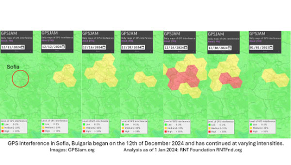
On Dec. 12, 2024, the European Union decided to include Bulgaria and Romania in the Schengen visa-free zone. On the same day, Bulgaria’s capital, Sofia, began experiencing interference with GPS signals. The interference, as reflected in aviation ADS-B systems and reported on GPSJam.org, continued through the new year and is ongoing as of this writing.
While these two events may be entirely unrelated, Vladimir Putin has a history of using GPS jamming and spoofing to show his displeasure with his neighbors growing closer to the West.
On Dec. 15, 2023, Poland activated a U.S. Aegis anti-missile system near its border with Kaliningrad, Russia. On the same day, Russia began jamming and spoofing GPS signals in northern Poland and parts of the Baltic. That interference persists to this day.
The interference in Sofia may be contributing to a prolonged Bulgarian political crisis. Politicians there have been struggling to form a new government since elections in October. Dec. 10 saw the beginning of a new attempt. Interference with GPS can undermine overall confidence in government systems and institutions — another of Putin’s goals for neighbors with whom he is displeased.
Another, though less likely, impact may be on Bulgaria’s electrical service. On Dec. 25, 2024, 20,000 households in western Bulgaria (Sofia is in the far west) lost electrical power and the outage continued for days. Many grid operators use GPS timing to help manage their systems. While press reports put the outages down to heavy snow and fallen trees, increased difficulty managing the grid might also be a factor.
Bulgaria’s GPS interference appears to be coming from somewhere in Sofia, not from Russian territory, as is the case in the Baltic. Yet Russia may still be involved, at least in a supporting role.
Advanced Navigation has finalized a multi-million dollar deal with Rheinmetall Defense Australia to provide fiber-optic gyroscope (FOG) inertial navigation systems (INS) for integration into Rheinmetall’s Boxer Combat Reconnaissance Vehicles (CRV), currently deployed by the Australian Army.
This agreement builds upon a previous collaboration in 2021, where Advanced Navigation supplied over 200 FOG INS units for the Boxer CRV as part of the LAND 400 Phase 2 Program.
Arming the Boxer CRV with FOG INS technology
The FOG INS technology developed by Advanced Navigation incorporates sophisticated algorithmic capabilities, resulting in a compact yet powerful navigation solution that outperforms traditional filter-based systems.
The system incorporates Advanced Navigation’s algorithmic technology, enabling the FOG INS to provide navigation data that surpasses outputs based on traditional filter methods while maintaining a compact form factor. The optical gyroscope’s design, free from moving parts, ensures exceptional resilience against shock and vibration-induced errors – a crucial feature for vehicles traversing challenging terrains.
Validated in real-world operations, the FOG INS integrated into the Boxer CRV, an armored 8×8 vehicle, offers enhanced troop safety, security and protection, coupled with high levels of firepower and mobility for sustained operations ranging from peacekeeping to high-intensity combat. The Boxer CRV is equipped with a reconnaissance mission module, including the two-person digital Lance turret, the first crewed medium-caliber turret to be put into service on the Boxer platform.
This partnership between Rheinmetall and Advanced Navigation aligns with the objectives of the Australian Defense Global Supply Chain (GSC) Program, aimed at expanding opportunities for Australian suppliers and boosting export prospects within the global defense industry.
Unidentified UAVs over military installations have sparked security concerns across the United States. Numerous sightings of suspected drones have been reported over residential areas, restricted sites and critical infrastructure, including reservoirs, electric transmission lines, rail stations, police departments and military bases. These incidents have prompted federal agencies to investigate and address increasing public concerns.
Government response
John Kirby, the White House national security spokesperson, provided an update regarding the recent drone sightings across the United States. According to Kirby, more than 5,000 drone sightings have been reported in recent weeks, but only about 100 of these required further investigation.
Kirby said the sightings have included a combination of lawful commercial drones, hobbyist drones and law enforcement drones, as well as some crewed aircraft and stars mistaken for drones.
However, the U.S. government is implementing precautionary measures. UAV detection and tracking systems are being installed at Picatinny Arsenal and Naval Weapons Station Earle in New Jersey. The FBI is spearheading investigations into the sightings, and local law enforcement agencies are conducting their own inquiries as well, CNN reported.
Several military installations have reported drone activity, including:
Picatinny Arsenal in New Jersey confirmed 11 unauthorized drone flights over its airspace.
Naval Weapons Station Earle in New Jersey has also reported drone sightings.
Ramstein Air Base in Germany experienced drone activity in early December 2024.
In an interview with ABC News, Alejandro Mayorkas, head of the Department of Homeland Security, said, “There’s no question that drones are being sighted.”
Impact on daily operations
The drone sightings have affected civilian infrastructure as well. Stewart International Airport in New York temporarily closed its runways for about an hour due to reported drone activity. Residents in several East Coast states have also reported seeing hovering and low-flying bright lights at night.
While the increase in sightings has raised concerns among residents and lawmakers alike, federal authorities maintain that most of these incidents do not pose a significant threat to public safety or national security.
Hexagon | NovAtel has released its lowest size, weight and power (SWaP) GNSS anti-jamming technology (GAJT), the GAJT-310. The GAJT line is a battle-proven solution for assured positioning, navigation and timing (A-PNT) designed to protect against hostile radio frequency interference for land, air and sea applications.
The new GAJT-310 features advanced anti-jam technology with minimal latency within a compact device. The reduced latency allows the GAJT-310 to protect signals immediately with no additional setup. It can be either an integrated enclosure or a federated option with a separate electronics card and controlled reception pattern antenna (CRPA). The device offers enhanced protection for GNSS signals on both L1 and L2 bands. The GAJT-310’s commercially exportable technology makes it accessible worldwide, allowing for broader implementation across various industries and regions.
“We’ve taken everything we learned from the successful in-theatre deployment of the GAJT-710 and GAJT-410 for NATO forces worldwide and built it into the GAJT-310,” stated Neil Gerein, vice president of product, aerospace and defense at Hexagon’s Autonomy & Positioning division. “Regarding assured positioning, navigation and timing, we believe every platform in any industry should be protected.”