Category: Defense

  • Ukraine attacks changed Russian GPS jamming

    Ukraine attacks changed Russian GPS jamming

    Two Russian airbases deep inside the country were attacked on December 5: the Engels-2 base in the Saratov region and Dyagilevo near Ryazan. The next day an oil tank at the Kursk airfield closer to the border with Ukraine was hit and set on fire.

    Reports from Russian witnesses and unofficial sources in Ukraine indicate that the attacks were carried out with UAVs operated by the Ukrainian military.

    The Russian government has long interfered with reception of GPS signals, especially near and within its own borders. The early December attacks seem to have motivated an increase in this activity.

    More Interference

    Information displayed by the website GPSJam.org indicates that, on the first day of the attacks, GPS interference was detected around Moscow, at two airbases to the east, and near the Engels-2 airbase.

    Photo:
    Image: RNT Foundation

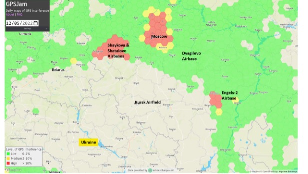
    GPSJam.org uses anomalies in crowdsourced aviation ADS-B data as an indicator of unreliable GPS signals. Note that no such information is available for much of Ukraine as commercial aircraft have been avoiding the airspace since the beginning of the current conflict.

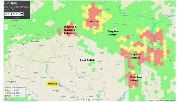
    The GPSJam.org depiction of the region six days after the attacks is quite different and has stayed much the same ever since. It seems to show greatly increased interference in the vicinity of the Engles-2 airbase, and new interference around the Marinikova airbase to the south along the Volga River.

    Photo:
    Image: GPSJam.org

    A History of Jamming and Spoofing

    The Russian government has been deliberately and systematically interfering with GPS signals in some places since at least 2016.

    An article in the Moscow Times that year bragged “The Kremlin Eats GPS for Breakfast.”

    The article documented a tech podcaster’s discovery that GPS L2 and L5 signals were being jammed and GPS L1 was being spoofed in the vicinity of the Kremlin. The combination of jamming and spoofing caused receivers in the area to report that, rather than being downtown, they were at the Vnukovo international airport some 20 kilometers away.

    The author of the article speculated the spoofing was to protect government officials and buildings from surveillance and attack by UAVs. Since 2013 most larger UAVs have been programmed by manufacturers with the locations of airports and to avoid them. Making UAVs near the Kremlin believe they were at an airport could be an effective part of an overall defense system by causing them to avoid the area.

    In 2017 the Resilient Navigation and Timing Foundation examined maritime AIS data and found similar spoofing activity had been occurring in the Black Sea for at least two years. A 2019 report by the nonprofit C4ADS expanded upon this work and revealed spoofing activity at various times and places across Russia. Almost 10,000 instances were documented across ten locations between 2016 and 2018. The report also linked much of the spoofing to the Russian Federal Protective Service and movements of senior government officials. This reinforced the idea that the spoofing was part of VIP protection efforts.

    Questions Abound

    It is easy to conclude that Russia’s recent increases in interference activity were in reaction to the UAV attacks on December 5 and 6.

    Western intelligence and military officials may be arriving at additional conclusions and asking themselves some intriguing questions. One might be why it took six days after the first UAV attack to implement the new interference scheme. The report by C4ADS made it clear that Russian equipment used for wide area spoofing is quite portable.

    Perhaps the delay was one of decision making. Some observers have commented that much of the direction for the current conflict comes directly from the top, rather than being delegated to field commanders. It could well be that it took that long for the Kremlin to realize that UAVs were involved and direct equipment to be deployed.

    Another question likely being asked is about the selection of locations where interference is being used. Interference activity was observed at the Engels-2 airbase before it was attacked. This seems to have greatly increased after the attack. Airfields at Dyagilevo and Kursk were also attacked, but no interference activity has been observed at either location.

    At the same time, substantial new interference activity has been observed at the Marinikova airbase, which was not attacked. There are likely several contributing factors to why some locations have been protected with jamming and/or spoofing and some not.

    While Russian forces have a fearsome reputation for electronic warfare and their ability to interfere with GPS signals, the amount of equipment and the number of trained operators may be limited. C4ADS’ finding that spoofing equipment was moved around with VIPs rather than permanently located around the nation could indicate a limited amount.

    This would mean that the bases and facilities to be protected must be prioritized. The lack of interference around Kursk and Dyagilevo could mean Russia sees them as less important, or less likely to be attacked again. New interference at Marinikova could mean it is a high value target and in need of protection.

    Conversely, some of the new activity could be designed to deceive and draw Ukrainian fire away from higher value targets and toward lower ones. Such is the potential nature of military strategy in war.

    Analysts are also probably asking questions about the effectiveness of jamming and spoofing as a defense against a determined UAV-operating opponent.

    Interference had been detected at Engels-2 before it was successfully attacked by one or more UAVs. This likely shows that Ukrainian forces disabled any geofencing that might have been originally included as part of the UAVs’ original design. They may have also upgraded the UAVs’ navigation receivers with hardware or software to make them much more resistant to interference from the ground.

    Navigation Warfare Increasingly Important

    Regardless, the UAV attacks and observed changes in interference activity reaffirm the importance of navigation warfare in modern conflicts. Knowing the location of your forces and of your targets has always been important. In an era of precision strike and autonomous systems, robust and resilient navigation that resists or overcomes interference is even more important.

    The U.S. military has long recognized this, establishing its Joint Navigation Warfare Center in 2004. The center focuses on the intersection of positioning, navigation, and timing with electronic warfare and cyber operations. Undoubtedly Russia has identical concerns and probably an equivalent organization.

    The current conflict in Ukraine will continue to raise questions for both sides. Not in question, though, is the importance of navigation warfare to this conflict, and that it will be increasingly important in future ones.

  • Space Force enhances GPS ground communications for greater resiliency

    Space Force enhances GPS ground communications for greater resiliency

    Modernized communications lines were installed at seven locations worldwide in an overhaul of the global communications network that provides command and control of the GPS constellation.

    Kwajalein Atoll in the Marshall Islands is one of seven locations that received a GPS communications network overhaul.(Photo: USGS)
    Kwajalein Atoll in the Marshall Islands is one of seven locations that received a GPS communications network overhaul.(Photo: USGS)

    From 2018 to 2022, GPS Product Support Delta — in conjunction with the Defense Information Systems Agency (DISA) — performed a complete overhaul of the global communications network required to provide command and control of the GPS satellite constellation. GPS Product Support Delta is under Space Systems Command of the U.S. Space Force.

    The project, called GPS Operations Network Enhancements (GONE), connected multi-protocol label switching internet protocol (IP)-based routers to modernized communications lines at seven key GPS facilities, replacing older serial lines.


    “With the GONE project completed, we are seeing a 75 percent reduction in communication line interruptions.”


    The GONE initiative “has significantly enhanced communications for GPS weapon systems,” said Brian Botka, Product Support Delta GPS program manager.

    “These upgrades not only increase communications speed and reduce overall down-time and adding a new paradigm in network resiliency with the networks capable of recovering in mere seconds from an outage or issue,” said Sean Foley, DISA technical project manager. “The system upgrades will continue to improve service to the warfighter as well as enable increased resiliency and network diversity for DISA.”

    The modernized communications lines were installed at

    • Schriever Space Force Base, Colorado
    • Vandenberg SFB, California
    • Cape Canaveral Space Force Station, Florida
    • Facilities in Hawaii, Ascension Island, Diego Garcia and Kwajalein Atoll.

    Throughout the COVID-19 pandemic, many of these locations were under strict lockdown or required long quarantine periods, making coordination and travel to remote locations more challenging.

    Lockheed Martin was the contractor who supported Product Support Delta GPS on the GONE project. “This was a collaborative effort with Product Support Delta GPS and DISA that required significant logistical efforts due to the COVID-19 pandemic,” said Christina Mancinelli, Lockheed Martin GPS Ground Programs director.

    “With the GONE project completed, we are seeing a 75 percent reduction in communication line interruptions, and we expect that metric to continue to improve,” Mancinelli said. “The migration of the GPS communication lines to the modern MPLS [multiprotocol label switching] routers and Ethernet-based connections continues the significant improvements in GPS ground capability, cybersecurity and reliability.”

    SSC is the USSF field command responsible for rapidly identifying, prototyping, and fielding resilient space capabilities for joint warfighters. It delivers sustainable joint space warfighting capabilities to defend the nation and its allies while disrupting adversaries in the contested space domain.

    SSC mission areas include launch acquisition and operations; space domain awareness; positioning, navigation, and timing; missile warning; satellite communication; and cross-mission ground, command and control and data.

  • Experts urge jamming detection network – Free webinar shows easy method using smartphones

    Experts urge jamming detection network – Free webinar shows easy method using smartphones

    By all accounts, it is getting worse. Hundreds of internet sites sell inexpensive devices to interfere with GPS and other GNSS signals. Estimates place the number of devices extant in the United States in the tens of thousands or more. Studies show accidental interference happens about ten times more often than deliberate jamming.

    In January a high-power signal in the Denver area impacted GPS reception across 4,000 square miles of airspace. The source was located, and the signal terminated after 33 hours.

    October saw a similar event near Dallas that lasted for 44 hours before it ended on its own. The source of that signal was never identified.

    The United States spends more than $2 billion a year to operate, maintain, and refresh GPS. Its positioning, navigation, and timing (PNT) services underpin virtually every technology, every facet of the economy. Yet, as was dramatically demonstrated at least twice this year, the nation does not have the ability to quickly characterize, locate and mitigate even the most powerful jamming signals.

    The President’s National Space-based Positioning, Navigation, and Timing Advisory Board is a panel of GPS and navigation policy experts that meets twice a year to advise the government on such issues. In November, they recommended that the government establish a “National GNSS interference detection and reporting network based on mobile wireless technology.


    Photo:
    National Space-based PNT Advisory Board, November 2022 Image: NASA

    The board made a similar recommendation in 2018 as a part of a more comprehensive discussion of actions the nation should take to protect GPS signals and users.

    The group’s most recent recommendation is to implement a detection network based on crowdsourcing and smart phones. This would be done in collaboration with wireless service carriers.

    Photo:
    Image: Page 17  gps.gov

    Yet cooperation of wireless carriers, while helpful, may not be necessary, according to at least some experts.

    Dr. Dennis Akos of the University of Colorado has developed an app for Android smart phones that enables devices to detect and automatically report interference with GPS and other GNSS signals. The app uses four detection methods based on location data already used by Android devices. These are comparing GNSS and network locations, checking the Android mock location flag, comparing the GNSS and Android system times, and observing the automatic gain control (AGC) and carrier-to-noise density (C/N0) signal metrics.

    Akos recently presented his work at an Institute of Navigation (ION) webinar. Video of the webinar is posted on YouTube. His paper can also be downloaded for free from the ION website.

    Commenting on Akos’ work, GNSS expert Logan Scott suggests that the U.S. government could use this new capability to establish the first phase of a national GPS/GNSS interference detection network with very little cost or effort.

    “The US government provides managed phones to many government employees,” he said. “Having an app like Dennis’s operating on an opportunistic basis, [only when GPS is on in the phone] would give access to millions of phones as observers. Bottom line, the US could stand up a national observation network on an accelerated timeline, understand the nature of the threat, and avoid the embarrassments of [events such as those that occurred at] DIA [Denver International Airport] and DFW [Dallas Fort Worth airport]. And it would not cost much.”

    If an effective system of some sort is not implemented, American lives and property will be at continued and increasing risk. In the words of the Advisory Board recommendation:

    Photo:
    Dr. Dennis Akos. Image from University of Colorado’s website.

    “Without a reliable, automated means of detecting and locating sources of GNSS interference, space-based PNT applications, and the general U.S. public, will continue to be plagued by potentially life-threatening and/or costly service disruptions that take days or weeks to resolve.”

  • Remote carrier flight test demonstrator successfully launched

    Remote carrier flight test demonstrator successfully launched

    Germany has successfully launched the Future Combat Air System (FCAS) Remote Carrier demonstrator, released by an A400M.

    The launch was carried out by the Bundeswehr Technical Center for Aircraft and Aeronautical Equipment (BAAINBw) and the German Aerospace Center (DLR), with collaboration from Airbus and German companies SFL and Geradts.The Remote Carrier demonstrator — an altered Airbus Do-DT25 drone — was launched from a device created specifically for the A400M to release remote carriers.

    After the remote carrier was launched, its Do-DT25 engines were ignited, and it continued to fly. Controls from the A400M were then handed to the ground operator who landed the drone successfully.

    As a part of the launch, the A400M was also evaluated to determine its role in FCAS to serve as a UAV launcher. Because the launch results were successful, Airbus is aiming to have the multi-role air lifter serve as the host of remote carriers.

    The remote carriers and A400Ms will have an integral role in expanding the use of unmanned systems by Airbus’s military transport aircraft in the FCAS.

    Photo: Airbus
    Photo: Airbus
  • SpaceX begins partner project designed for national security

    SpaceX begins partner project designed for national security

    Photo:
    Image: 3DSculptor/iStock/Getty Images Plus/Getty Images

    The private spaceflight company, SpaceX, has undertaken a partner project in addition to its existing space efforts ranging from sending satellites and people to space, to providing a brand of commercial internet connection to remote areas.

    The new partner project, Starshield, will join Starlink in providing secure, broadband internet connection to customers. However, there is a stark difference between the partner projects.

    Starlink technology has end-to-end user data encryption to secure its network as it was designed for commercial customers. However, the Starshield project is intended for government use in national security efforts. Therefore, it is equipped with an additional high-assurance cryptographic feature to host payloads and process data in a secure way aligning with government national security requirements.

    As reported by SpaceX, Starshield has three focus areas including: Earth observation, global communications, and hosted payloads. Starshield’s satellites can integrate with a variety of different payloads and the constellation has a low-Earth orbit (LEO) design making it robust to on-orbit assets.

    SpaceX continues to work closely with the United States Department of Defense by providing innovative space technology.

  • Editorial Advisory Board Q&A: Improving the GPS program

    What works well and what needs improvement in the GPS program regarding technology, policy, or management?


    Jules McNeff
    Jules McNeff

    “GPS technology and operational performance continue to set the standard for GNSS, but necessary modernization is late to need, and becoming later by the day. This reflects what I see as loss of focus on ‘Job 1’ (delivering effective GPS service to the Joint Force) and a diminution in the sense of ‘GPS uniqueness and exceptionalism’ in its management as it was fragmented within the old SMC and is no longer the ‘shiny new object’ within the evolving Space Force. Even so, its value to its global user base, and particularly to U.S. and allied militaries, is stronger than ever and it remains the cornerstone among diverse complements within the Department of Defense PNT Enterprise. It is incumbent on the DOD to ensure the GPS services our warfighters will depend on can sustain that vital role.”

    — Jules McNeff
    Overlook Systems Technologies


    Ellen Hall
    Ellen Hall

    What works well? There is good focus on the areas that need development: M-code, CRPA, resiliency. What needs improvement? More thorough and timely sharing of information by the government with industry. — Ellen Hall, Spirent Federal Systems


    Mitch Narins
    Mitch Narins

    The ‘GPS program’ has set the standard for all other GNSS efforts, but there are always lessons to be learned. I have full confidence that USSF leadership is well equipped to deal with both the technology and management aspects of the program. As for policy, which supports military and civil uses worldwide, there is a clear distinction, based on mission areas and acceptable risk. However, risks to civil users have increased as GPS PNT services permeate all civil critical infrastructure systems. Therefore, system improvements directed at civil user PNT resilience should be given a higher priority and funded through appropriate civil channels. I encourage a policy to enable more resilient PNT services from space — and to consider that by looking both ‘up’ and ‘down’ for PNT services, unfortunate ‘situations’ might be avoided.
    — Mitch Narins,
    Strategic Synergies


    Bernard Gruber
    Bernard Gruber

    “One of the most consistent and enduring enablers of the GPS program is national policy. NSPD-39 re-baselined requirements buttressed by GPS being provided to the world for free, that it must be sustained and have an ever-present focus on performance improvement and robustness. Accordingly, NSPD-7 acknowledges an ever-changing world with a nod to cybersecurity, augmentations and direction to “improve NAVWAR capabilities to deny hostile use of United States Government space-based PNT services, without unduly disrupting civil and commercial access to civil PNT services.”
    — Bernard Gruber,
    Northrop Grumman

  • DOD office recommends D-Fend solution to counter rogue drones

    DOD office recommends D-Fend solution to counter rogue drones

    The recommendation is based on demonstrations at Yuma Proving Ground, Arizona

    In September 2021, EnforceAir helped safeguard Pope Francis and a crowd of 60,000 Slovakia. A ground-level tactical kit provided 360-degree azimuth coverage, fending off a rogue drone and sending it back to its original takeoff position. (Photo: D-Fend)
    In September 2021, EnforceAir helped safeguard Pope Francis and a crowd of 60,000 in Slovakia. A ground-level tactical kit provided 360-degree azimuth coverage, fending off a rogue drone and sending it back to its original takeoff position. (Photo: D-Fend)

    EnforceAir, a solution that counters small unmanned aerial systems (sUAS), has been recommended by the U.S. Department of Defense’s (DoD) Joint Counter-sUAS Office (JCO).

    Developed by D-Fend Solutions, EnforceAir was recommended as a subcomponent integrated within SAIC’s Valkyrie C2 system.

    EnforceAir was recognized for its RF detection and mitigation, its demonstrated impressive effectors and its ability to force land certain drones. D-Fend Solutions’ EnforceAir was the only RF cyber takeover technology named.

    EnforceAir automatically executes cyber drone detection and takeover mitigation of rogue drones for safe landings and outcomes, empowering security agencies and professionals with control while preserving operational continuity.

    The JCO recommendation is the result of a formal U.S. government evaluation event held at Yuma Proving Ground in April 2022.

    “It’s an honor to be recognized by the U.S. DoD Joint C-sUAS Office, following a rigorous demonstration and evaluation” said Zohar Halachmi, Chairman and CEO of D-Fend Solutions. “We’re excited to provide continued support for the counter-drone mission, within a layered defense, integrated in the most advanced C-UAS systems for the nation’s defense.”

    EnforceAir is D-Fend’s flagship offering. With hundreds of deployments worldwide, EnforceAir focuses on the most dangerous drone threats in the military, public safety, airport, prison, major event and critical infrastructure environments.

  • Orolia’s rescue beacons head to US Army

    Orolia’s rescue beacons head to US Army

    Latest Orolia Defense & Security personal rescue beacons deliver Cospas-Sarsat second-generation signaling

    Photo: DVIDS
    Photo: DVIDS

    Orolia Defense and Security is now shipping its PRSS1b Personnel Recovery Devices to the U.S. Army. The beacon uses a commercial GNSS chipset that can be replaced by SASSM or M-Code-capable receivers depending on customer needs.

    Orolia’s PRSS1b PRD provides second-generation Cospas-Sarsat signaling that delivers faster and greater location accuracy than previously fielded tactical location devices.

    Photo: Orolia
    Photo: Orolia

    Cospas-Sarsat is an international, humanitarian search-and-rescue system that uses space-based technology to detect and locate model 406 emergency beacons carried by ships, aircraft or individuals venturing into remote areas, often inaccessible by mobile phone. The system consists of a network of satellites, ground stations, mission control centers (MCCs) and rescue coordination centers (RCCs) that work together when a 406 beacon is activated.

    Through collaboration with the Army, Orolia produced a robust, user-friendly and highly reliable device to locate personnel who become isolated, missing, detained or captured.

    Orolia conducted a demonstration in October simultaneously on multiple continents, showing its technology working with the worldwide coverage provided by the Cospas-Sarsat infrastructure. The demonstration yielded beneficial data to support the qualification of Orolia’s Personnel Recovery Device and helped inform government stakeholders on the readiness of the second-generation ground and satellite infrastructure.

    A U.S. Army HH-60 Black Hawk helicopter lowers a volunteer from Central Washington Mountain Rescue via the hoist system during a training exercise.(Photo: U.S. Army)
    A U.S. Army HH-60 Black Hawk helicopter lowers a volunteer from Central Washington Mountain Rescue via the hoist system during a training exercise.(Photo: U.S. Army)

    Also in October, Orolia received Cospas-Sarsat certification for its Ultima-DT ELT emergency transmitter, designed for use on aircraft. All 406-MHz emergency beacons are digitally coded and transmit distress signals immediately upon activation on a proprietary radio wavelength.

    The three main types of 406 distress beacons and the kinds of situations each are designed for wilderness use, marine and aviation. (Image: Cospas-Sarsat)
    The three main types of 406 distress beacons and the kinds of situations for which each is designed: wilderness, marine and aviation environments. (Image: Cospas-Sarsat)
  • FCC creating Space Bureau: Implications for Ligado decision?

    FCC creating Space Bureau: Implications for Ligado decision?

    Speaking at the National Press Club on Nov. 3, Federal Communications Commission (FCC) Chair Jessica Rosenworcel announced a plan to reorganize the agency to include a Space Bureau and a standalone Office of International Affairs.

    The rationale for these moves, as explained in a press release, is to “help ensure that the FCC’s resources are better aligned so that the agency can continue to fulfill its statutory obligations and keep pace with the rapidly changing realities of the satellite industry and global communications policy.”

    While neither GPS nor Ligado were mentioned in the press release, some have taken establishment of a Space Bureau as a sign the FCC may be reconsidering its decision regarding Ligado Networks.

    By creating a Space Bureau, the reasoning goes, the commission is acknowledging a need to better focus on space-based users. A report this summer from the National Academies of Science said that some GPS and Iridium users would be harmed if Ligado Networks is allowed to operate as planned.

    Since the commission seems to be trying to prevent future Ligado-like controversies, it may also be ready to reconsider its Ligado decision. In February 2020 seven different petitions were filed by organizations and groups of organizations formally asking the FCC to reconsider. The commission has not yet responded to any of the petitions.

    Few can disagree that aligning resources to more effective address constituent concerns is a good idea. At the same time reorganizations rarely, in and of themselves, prevent problems from recurring.

    As one example, the FCC had been criticized for years for not including analyses of total costs and benefits to the nation of decisions it was considering. In January 2018, FCC Chairman Ajit Pai established the FCC’s Office of Economic Analysis to address those concerns.

    Yet, despite Pai still being chair, the Office of Economic Analysis was not called upon to provide input to the commission’s deliberations on Ligado Network’s application. One of the pending petitions for reconsideration asserts that if the office had done a cost-benefit analysis, the commission’s decision would have been different. This is because the cost of even a small service degradation for potentially millions of GPS users would have very likely easily outweighed any benefit to the nation of granting Ligado Networks permission to operate.

    Photo: Bill Oxford/iStock/Getty Images Plus/Getty Images
    Photo: Bill Oxford/iStock/Getty Images Plus/Getty Images
  • GPS integrity system Skysweeper monitors GPS signals for interference

    GPS integrity system Skysweeper monitors GPS signals for interference

    logo Skyweeper SJAWSCanadian-based technology company SJAWS Technologies has developed a GPS monitoring system to assure the reliability of signals. The company’s Skysweeper service monitors the integrity of GPS signals and alerts users when interference occurs.

    “The GPS navigation signals that maritime, terrestrial and aviation industries rely on are all vulnerable to interference and manipulation,” said SJAWS CEO Peter Mueller, adding that thousands of spoofing and jamming incidents occur every year, including to U.S. Navy vessels and commercial aircraft.

    SJAWS will be at the Canadian Aerospace Conference in Ottawa, Ontario, on Nov. 8–9, and will be available to meet ITB obligors and strategic partners in person or by video to present the latest update on their technology.

    Mueller started SJAWS this year with Liz Hennessy after 15 years of GNSS network technology experience with Rx Networks. Hennessy co-founded Goldtouch Technologies Inc., manufacturer of ergonomic PC peripherals.

  • InfiniDome releases GPSdome 2 dual-band anti-jamming technology

    InfiniDome releases GPSdome 2 dual-band anti-jamming technology

    infinidome logoInfiniDome has released GPSdome 2, its newest anti-jamming solution. The cost-effective and lightweight device provides simultaneous dual-frequency protection from three directions of attack.

    GPSdome 2 is a high-end solution tailored to defend small- to medium-sized tactical UAVs as well as manned and unmanned ground vehicles.

    Disruptions in critical positioning, navigation and timing (PNT) data mean loitering munitions that never find their targets, UAVs that fall to the ground, and ground vehicles that cannot be managed.

    With a small form factor (500 g, 87 mm x 91 mm x 61.55 mm) and minimal power consumption, GPSdome 2 is suitable for loitering munitions as well as drones and UAVs, increasing resiliency while prolonging mission time and providing a superior return on investment. Fully retrofit and completely standalone, the system is compatible with almost any off-the-shelf GNSS receiver on the market as well as standard active GNSS antennas, meaning that it can be integrated into existing GPS systems or into new product lines, manned or unmanned.

    With sophisticated algorithms and a proprietary RFIC, GPSdome 2 analyzes RF interference in the environment and combines multiple antenna patterns to create and dynamically steer three nulls in the direction of any hostile signal.

    GPSdome 2 provides simultaneous dual-frequency protection (GPS L1 + L2 or GPS L1 + GLONASS G1), creating up to three nulls, protecting from three jamming directions within each band in real time, making it suitable for PNT applications.

    The GPSdome 2 is a dual-use, non-ITAR device and comes with optional mil-spec compliance. It has been chosen by an Israeli defense contractor for integration with its platforms.

  • Starlink signals can be reverse-engineered to work like GPS

    Starlink signals can be reverse-engineered to work like GPS

    Photo: Official SpaceX Photos
    Photo: Official SpaceX Photos

    A team of researchers from the University of Texas Austin (UTA) have shown the Starlink broadband constellation’s potential to serve as a backup for GPS.

    Todd E. Humphreys headshot
    Todd E. Humphreys

    The researchers, led by Todd Humphreys and funded by the U.S. Army, examined the downlink signal structure of the SpaceX Starlink constellation of ultrafast broadband satellites in low-Earth-orbit (LEO), reported MIT Technology Review. The team showed that Starlink could serve as a useful backup to GPS.

    For the past two years, Humphreys’ team at UT Austin’s Radionavigation Lab has been reverse-engineering signals sent from thousands of Starlink internet satellites to ground-based receivers. Humphreys told the review that regular beacon signals from the constellation, designed to help receivers connect with the satellites, could form the basis of a useful navigation system.

    SpaceX opted not to participate in the research.

    Read the research paper here.

    Title: Signal Structure of the Starlink Ku-Band Downlink

    Authors: Todd E. Humphreys, Peter A. Iannucci, Zacharias Komodromos, Andrew M. Graff

    Abstract: We develop a technique for blind signal identification of the Starlink downlink signal in the 10.7 to 12.7 GHz band and present a detailed picture of
    the signal’s structure. Importantly, the signal characterization offered herein includes the exact values of synchronization sequences embedded in the
    signal that can be exploited to produce pseudorange measurements. Such an understanding of the signal is essential to emerging efforts that seek to dual-purpose Starlink signals for positioning, navigation, and timing, despite their being designed solely for broadband internet provision.