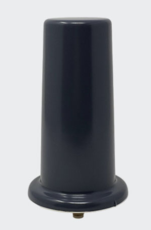
Tallysman Wireless has added the housed AJ977XF triple-band antenna with anti-jam technology to its line of GNSS products.
According to Tallysman, the AJ977XF uses a novel stacked antenna phased array that creates a null of typically 20-dB attenuation in the antenna’s radiation pattern from the horizon to an elevation angle of approximately 15 degrees.
The null in the radiation pattern strongly mitigates in-band and out-of-band signals. For example, the AJ977XF will continue to function in the presence of a ground-level 600-watt jamming signal, 100 meters or greater from the antenna. In addition to the null in the radiation pattern, the antenna’s OP1dB (compression point) is 15 dBm, which strongly protects the antenna’s low-noise amplifier (LNA) from saturating.
The triple-band AJ977XF antenna supports GPS L1/L2/L5, GLONASS G1/G2/G3, Galileo E1/E5ab and BeiDou B1/B2ab), and, in the region of operation, satellite-based augmentation systems (SBAS): WAAS (North America), EGNOS (Europe), MSAS (Japan), or GAGAN (India).
The AJ977XF is housed in a through-hole mount, weatherproof (IP67) enclosure. L-bracket (PN 23-0040-0) or pipe (23-0065-0) mounts are available for permanent installations.
The radio frequency spectrum has become congested worldwide as many new LTE bands have been activated. Their signals or their harmonics can affect the proper operation of GNSS antennas and receivers.
In North America, the planned Ligado service, which will broadcast in the frequency range of 1526 to 1536 MHz, can negatively affect the reception of GNSS signals. Similarly, new LTE signals in Europe [band 32 (1452–1496 MHz)] and Japan [bands 11 and 21 (1476–1511 MHz)] also have been shown to affect GNSS signal reception. Tallyman’s new AJ977XF mitigates the effects of these new signals.
Military officials from across all branches, federal security personnel, and industry leaders gathered at the AUVSI Defense conference, held Sept. 22 in Alexandria, Virginia, to discuss critical issues surrounding the integration of uncrewed technologies.
In a publication released Oct. 11, AUVSI Senior Economic Research Analyst Aaron Bull summarized key topics discussed at the event, including:
defense priorities for the next-generation uncrewed system
how uncrewed systems will impact the ways wars are fought
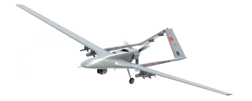
lessons learned by senior defense leaders from the Bayraktar TB2 in Ukraine.
The Bayraktar TB2 surveillance/attack drone (Photo: Baykartech)
Highlights from the Report
Flexibility in the fighting force is needed, which affects the defense requirements for autonomous vehicles heading to the battlefield.
Multiple speakers pointed to the Turkish Bayraktar TB2, a cost-effective combat-capable drone purchased and fielded by the Ukrainian armed forces that has been a game changer for Ukraine since the war began. While the drone is not top of the line, it was fielded quickly, required little training and could be fitted for a variety of purposes. As a result, “Nearly every speaker came prepared to discuss the need for developing multiple layers of flexibility around the U.S. fighting force,” Bull writes.
An uncrewed vehicle that can be refitted for multiple missions of different types offers an inherent advantage for missions, and it requires supporting logistical infrastructure.
Requirements include:
flexibility and disguise of role
ability to outfit to different technical and operating capabilities
flexibility to operate with different levels of human interaction
Global corporation VIAVI Solutions Inc. has completed the acquisition of Jackson Labs Technologies, a leader in positioning, navigation and timing (PNT) solutions for critical infrastructure serving both military and civilian applications.
Jackson Labs develops and supplies modules, subsystems and box-level solutions that include front-end receivers, transcoders, rack-mounted equipment, and patented retrofit technology. Their broad customer base includes armed forces, defense contractors, energy distribution infrastructure, low-Earth-orbit (LEO) operators and 5G service providers.
Jackson Labs’ next-generation M-code solutions complement and advance VIAVI’s timing and synchronization portfolio at a time when PNT requirements for defense, space, commercial aviation, transportation and telecommunication networks are expanding and becoming increasingly critical.
“As telecommunications, avionics and mission-critical infrastructure adopt next-generation technology, legacy timing and synchronization protocols are no longer sufficient. Jackson Labs is a trusted provider of PNT solutions in these markets, and we look forward to addressing these opportunities together,” said Oleg Khaykin, president and CEO of VIAVI. “With this acquisition, we are continuing to drive operational scale via the addition of advanced technology and high-performance products that address market segments with strong growth and profitability.”
“Being a part of VIAVI will significantly expand Jackson Labs Technologies’ market reach worldwide, and allow us to further deliver world-class solutions for the rapidly developing PNT landscape as it enters a new era,” said Said Jackson, CEO of Jackson Labs Technologies.
DelMorgan & Co. acted as the exclusive financial advisor to Jackson Labs in connection with the transaction. Terms of the transaction are not being disclosed.
About VIAVI
VIAVI s a global provider of network test, monitoring and assurance solutions for communications service providers, enterprises, network equipment manufacturers, original equipment manufacturers, government and avionics. It helps customers harness the power of instruments, automation, intelligence and virtualization.
VIAVI is also a leader in light management solutions for the anti-counterfeiting, consumer electronics, industrial, government and automotive markets.
VIAVI operates offices throughout North, Central and South America, Europe, Africa, the Middle East, and the Asia-Pacific, including China and Japan.
APNT/Space modernization gives U.S. Army a clearer view of multi-domain battlefield
U.S. Army soldiers experiment with new assured PNTT/space equipment during the 2021 PNT Assessment Exercise at White Sands Missile Range, New Mexico. (Photo: U.S. Army/Austin Thomas, Army Futures Command)
News from U.S. Army Futures Command
The Assured Positioning, Navigation and Timing/Space Cross-Functional Team — APNT/Space CFT — takes a multi-dimensional approach to understanding and preparing for future warfare.
The team — based at Redstone Arsenal, Alabama — is dedicated to advancing the Army’s tactical and navigational capabilities and ensuring tomorrow’s soldiers have the modern situational tools they need to maneuver with the utmost accuracy, safety and skill.
The CFT is making significant progress toward this goal by leveraging iterative developments, remaining open to new technologies and committing to continuously evolving PNT equipment and systems to meet changing threats and needs.
“Our cross-functional team will continue to assess and strengthen the future of our operational environments, emerging threats and technologies to ensure our Army is prepared for 2030 and beyond. We will continue to support the requirement development and delivery of trusted solutions to the soldier,” said Michael C. Monteleone III, director of the APNT/Space CFT, reiterating the team’s focus on nimbly and steadfastly enabling the success of future warfighters.
According to Army planners, the likelihood of future operations spanning diverse domains — air, land, sea, space, cyberspace and the electromagnetic spectrum — means soldiers will need more flexible and far-ranging resources to inform their movements and operations.
To facilitate this, the APNT/Space CFT conducts rigorous field experimentation and prototype assessment and drafts detailed requirements for state-of-the-art materiel solutions, which the Army can then further develop and employ to improve information gathering and data precision without disrupting or adding extra burden to soldier operations.
Experimentation for APNT/Space happens on the ground and in the air, including along the electromagnetic spectrum — sometimes referred to as the “invisible battlefield” — and in the low Earth orbit of space.
Within these frequently interwoven domains, the APNT/Space CFT investigates alternative GPS capabilities and other navigation resources already in use, while also evaluating how to best integrate new anti-jamming functions, electronic support, inertial navigation systems and vision-based navigation platforms.
The CFT coordinates regularly with industry, joint partners and other government agencies to identify and explore solutions that are modular, scalable and an excellent fit for multiple platforms, as well as the upgrades and adjustments that occur to equipment and systems over time.
Modern PNT tools being developed and fielded include mounted, dismounted and alternative navigation systems, situational awareness devices, and next-generation sensors that allow for optimum flexibility and performance against threats.
Within the realm of space, the CFT is shaping a strategy to provide survivable, responsive and resilient intelligence, surveillance and reconnaissance and communications capabilities in low Earth orbit, complete with the ability to share information rapidly and securely with tactical commanders on the ground.
The team’s experts are also focused on understanding and preparing for the future of navigation warfare, or NAVWAR, which will require sophisticated offensive and defensive systems to produce tactical advantages and enable overmatch. To encourage synchronization of efforts on this front, the CFT is working closely with Army partners to draft an overarching NAVWAR strategy that aligns with U.S. Department of Defense NAVWAR plans but is also tailored to unique Army needs.
By studying and preparing for multi-domain operations and experimenting with the newest technologies available, the APNT/Space CFT is playing an integral role in helping the Army to equip soldiers with more mobile, scalable and interoperable navigation devices, in turn strengthening the agility of the future force.
AeroVironment’s Puma is hand-launched. (Photo: Lance Cpl. Frank Cordoba/U.S. Marine Corps)
AeroVironment Inc. has introduced Puma VNS, a visual-based navigation system for its Puma 2 AE and Puma 3 AE small unmanned aircraft systems (SUAS). The system enables navigation across GPS-denied environments.
Puma VNS will receive frequent software and hardware updates, providing operators with advanced navigation capabilities, features and functionality. The system will also enable integration of future autonomy capabilities.
“Puma VNS gives operators an unprecedented advantage in the battlefield,” said Trace Stevenson, AeroVironment vice president and product line general manager for SUAS. “Operators now can execute missions with more confidence in GPS-contested environments with the system’s new navigational capabilities.”
VNS uses a suite of downward-looking sensors to gather imagery data and track features on the ground, as well as an embedded computing module to process and determine the precise location of an aircraft while in flight. The system automatically transitions to and from GPS-denied navigation mode without operator input.
Puma VNS is available as an add-on option for new Puma 3 AE system orders and as a retrofit kit for fielded Puma 2 AE and Puma 3 AE systems.
New Combined Program Office to enhance U.S. ability to prevail against threats in space, including new hypersonic weapons
Space Systems Command (SSC) is leading a new tri-agency Combined Program Office (CPO) comprised of representatives from SSC, the Space Development Agency (SDA) and the Missile Defense Agency (MDA). The CPO was established on Aug. 19 to enhance the United States’ ability to deter, defend and win against competitors’ challenges in space.
The Space Acquisition Council, established by Congress to manage space procurements across the Department of Defense, concurred on the CPO proposal, enabling the coordinated development and fielding of capabilities in the missile warning (MW), missile tracking (MT), and missile defense (MD) mission areas.
The CPO will address growing challenges resulting from the transition of space from a peaceful domain to one that is congested, contested and competitive. Other nations now challenge access to and movement in space, and have demonstrated the capability and intent to hold U.S. and allied space assets at risk.
“The MW/MT/MD mission is driving the U.S. Space Force’s new ‘requirements to execution’ roadmap, rapidly turning USSF Force Design into operational capabilities that will outpace and defeat very determined threats,” said U.S. Space Force Col. Brian Denaro, Space Sensing program executive officer and leader of the new CPO. “Our adversaries continue to develop missile technologies that are faster burning, dimmer and more maneuverable. This Combined Program Office, in partnership with SDA and MDA, will drive critical integration across a new resilient multilayer architecture that will warn, track and defeat these increasingly advanced and elusive missile threats.”
Establishing this partnership among MW/MT/MD acquisition organizations will enhance the interface between requirements, operators and users, optimizing delivery of integrated and resilient sensor-to-shooter capabilities for the United States and its allies.
“We are focused on delivering MW/MT/MD capabilities to the warfighter and the nation,” said U.S. Army Lt. Col. Alexander Rasmussen, Tranche 1 Tracking Layer program manager, SDA. “The Combined Program Office is a critical component in delivering this capability and enabling our nation to counter hypersonic and advanced missile threats. Together, SDA, MDA and SSC will ensure a synchronized end-to-end capability that sets the foundation for a continually evolving and advancing MW/MT/MD architecture.”
“With the emerging advanced threats, space-based sensors are essential to missile defense,” said Walter Chai, director for space sensors at MDA. “The close collaboration between SDA, SSC and MDA will ensure that we are able to defeat these threats.”
The CPO organizational structure integrates strategic decision-making across the interagency, establishing:
clear roles, responsibilities, and authorities for SSC, SDA, MDA and other mission partners
end-to-end system of systems accountability between requirements and weapon system delivery
development and management of standards (models, open architecture, data, etc.)
integration with operators, combatant commands and other weapon systems.
Space Systems Command is the U.S. Space Force field command responsible for rapidly identifying, prototyping and fielding resilient space capabilities for joint warfighters. SSC delivers sustainable joint space warfighting capabilities to defend the nation and its allies, while disrupting adversaries in the contested space domain. SSC mission areas include launch acquisition and operations; space domain awareness; positioning, navigation and timing; missile warning; satellite communication; and cross-mission ground, command and control, and data.
Light and with low power consumption, the NavGuard NOCTA Mini is a fully integrated day and night optical navigation module for jam-proof and spoof-proof operations
Photo: Asio Technologies
Asio Technologies has launched the NavGuard NOCTA Mini, a tiny jam-proof aerial optical positioning system for unmanned aerial systems (UAS).
NavGuard is a real-time optical navigation system that enables seamless and accurate autonomous GNSS-free navigation for tactical UAS platforms in areas where the GNSS signal is spoofed, jammed or unavailable. Using machine vision technology, artificial intelligence, advanced optics and sensor fusion, NavGuard can be installed on various unmanned aerial platforms to enable safe and sustainable 24/7 drone missions under complete GNSS blackout.
NavGuard’s new mini version, NOCTA Mini, is suitable for installation on small UAS. Lighter than other NavGuard systems and with low power consumption, it is a fully integrated day and night optical navigation module for jam-proof and spoof-proof operations.
NOCTA Mini enables UAS to operate beyond visual line of sight from takeoff to landing. Because it is based on machine vision, the system is drift-free. The self-contained system incorporates a computing module, geographic information system (GIS) infrastructure, and day and night cameras.
Designed for applications such as defense, homeland security and infrastructure security, it is a suitable solution for tactical UAS missions where payload capacity and flight time are limited, and continuous operation under all conditions is critical.
Galileo Control Centre in Oberpfaffenhofen, Germany. (Photo: ESA)
News from the European Space Agency (ESA)
Europe’s Galileo satellite navigation system continues to evolve. For the first time, end-to-end testing of the Galileo system demonstrated signal acquisition of an improved version of the Public Regulated Service (PRS), the most secure and robust class of Galileo services.
The system test extended from the Galileo Security Monitoring Centre in Spain and the Galileo Control Centre in Germany to a Galileo satellite at ESA’s ESTEC technical heart in the Netherlands, which then broadcast in turn to a user receiver.
Galileo’s PRS is an encrypted navigation and timing service for governmental authorized users and sensitive applications intended to remain available even in scenarios where other Galileo services might be degraded or jammed.
An initial version of the PRS signal has been broadcast by the satellites up to now, but as of next year the signals will evolve into an enhanced version known as Full Operational Capability Public Regulated Service (FOC PRS), which has been defined in close collaboration with the European Commission, the European Union Agency for the Space Programme (EUSPA) and the EU Member States.
The system’s FOC PRS capability is being enabled by an expansion of the Galileo ground mission segment — important upgrades of the Galileo Security Monitoring Centres (GSMCs) in St. Germain-en-Laye, France, and Madrid, Spain. These two sites oversee PRS provision and monitor its performance.
This coming version of the security monitoring centers, set for the following year, is being developed by an industrial consortium led by Thales Alenia Space in France.
Meanwhile the progressive deployment of remote system infrastructure is taking place over the course of this year, readying Galileo sensor stations to receive the upgraded PRS signals.
Upgrade of Galileo Sensor Station on Norway’s remote Jan Mayen Island in the Arctic Ocean. (Photo: ESA)
“To qualify, the FOC PRS Signal in Space required a major Galileo end-to-end test, demonstrating the compatibility of the space segment with the ground and user segments, called the System Compatibility Test Campaign (SCTC),” explained Federico Di Marco, ESA SCTC test director. “This test involved all Galileo key players spread across Europe, requiring close cooperation between the teams and months of preparation.”
The SCTC was led by an ESA engineering team from the agency’s ESTEC technical center in Noordwijk, the Netherlands supported by the System Engineering Technical Assistance industrial team led by Thales Alenia Space in Italy and in close collaboration with the operations team supervised by EUSPA.
“The testing involved three centers across Europe: the GSMC in Madrid, the Galileo Control Centre in Oberpfaffenhofen, and ESTEC hosting an actual Galileo satellite plus FOC PRS user receivers,” added Edward Breeuwer, who is in charge of Galileo system qualification at ESA.
FOC PRS test receiver developed by Antwerp Space under ESA contract. (Photo: ESA)
The FOC PRS signal was generated at the GSMC, sent to the German control center, then uplinked to the Galileo satellite at ESTEC, where the satellites are tested for space in advance of launch. The Galileo satellite then broadcast the FOC PRS signal in turn, to be picked up by a pair of receivers also on site: one developed by Antwerp Space under ESA contract and the other developed by Leonardo as part of a national development undertaken by Italy’s Competent PRS Authority, charged with overseeing the country’s PRS use.
“This marks the first time we have integrated such a nationally developed receiver within a system test activity,” said Fabio Covello, who oversees system security for ESA. “Having achieved this for PRS makes us very proud. We are confident that this experience can pave the way for future fruitful collaborations between the Galileo Programme and EU Member States, in the frame of specific tests to guarantee compatibility between the ESA-developed system and nationally developed PRS receivers.”
This successful outcome sets the scene for the PRS qualification at ground segment and system level, followed by operational validation planned in coming months, culminating in the first FOC PRS Signal In Space operational broadcast, in the course of next year.
FOC PRS test receiver developed by Leonardo as part of a national development undertaken by Italy’s Competent PRS Authority, charged with overseeing the country’s PRS use. (Photo: ESA)
“The new LightSquared business plan and the new FCC rules significantly expand the terrestrial transmission increasing the potential for interference to GPS receivers,” the U.S. departments of Defense and Transportation (DOD and DOT) wrote to the Federal Communications Commission in 2011 after the FCC granted the company permission to offer broadband via its satellite and base station networks to a wide variety of mobile broadband partners. The move — heralded by supporters as hastening the advent of 4G services across the country, especially in underserved communities — sent shockwaves across the GNSS/PNT community, which opposed the plan forcefully for the threat it posed to GPS.
Reborn in December 2015 as Ligado Networks, the company obtained the FCC’s unanimous approval in April 2020 for the use of spectrum near the L-bands used by GPS for its 5G network. It is scheduled to launch its first deployment at the end of September.
Nearly all the federal government, including DOD and DOT, as well as most manufacturers of GNSS receivers, are very strongly opposed. On September 9, the National Academies of Science, Engineering and Medicine’s Committee to Review FCC Order 20-48 will release its independent evaluation of the issue, as mandated by the 2021 National Defense Authorization Act.
The study, begun in May 2021, considered three issues:
1. Which of two prevailing proposed approaches for evaluating harmful interference is most effective to mitigate the risk of harm.
2. The potential for harmful interference from Ligado to mobile satellite services — such as Iridium.
3. The feasibility and practicality of the remedies proposed by the FCC.
I am very pleased to announce that Prof. Penina “Penny” Axelrad has joined GPS World’s Editorial Advisory Board.
Penny is a University of Colorado (CU) Distinguished Professor in the Ann and HJ Smead Department of Aerospace Engineering Sciences. She received her B.S. and M.S. degrees in Aeronautical and Astronautical Engineering from MIT and her Ph.D. in Aeronautics and Astronautics from Stanford University. She has been a member of the faculty at CU since 1992, serving as primary advisor for 25 Ph.D. graduates and many M.S. and undergraduate research students.
Penny has been active in research on GPS and PNT technology and applications for aircraft, spacecraft and remote sensing, as well as estimation of satellite orbits and attitude, since 1985, co-authoring more than 60 journal papers and 130 conference papers. She has served as principal investigator or co-investigator on grants and contracts totaling $17 million. She is a Fellow of the Institute of Navigation and the American Institute of Aeronautics and Astronautics, and a member of the National Academy of Engineering. Since 2013 she has served as a member of the National Space-Based Positioning, Navigation and Timing (PNT) Advisory Board.
I overlapped with Penny at MIT in the mid-1980s. Now, nearly 40 years later, I look forward to her contributions to this magazine.
BAE Systems has received a $13 million contract for advanced GPS technology to protect U.S. F-15E aircraft from GPS signal jamming and spoofing. The company’s Digital GPS Anti-jam Receiver (DIGAR) will ensure the reliability of military GPS systems for aircraft operating in challenging signal environments.
DIGAR uses advanced antenna electronics, high-performance signal-processing and digital beamforming — a capability that combines 16 steered beams — for better GPS signal reception and superior jamming immunity. These capabilities are critical for high-speed aircraft as they maneuver through the battlespace.
The F-15 Eagle is the second U.S. Air Force fighter platform to receive DIGAR GPS upgrades, following the F-16 Fighting Falcon. DIGAR also provides advanced GPS capabilities for intelligence, surveillance and reconnaissance aircraft as well as multiple unmanned aerial vehicles.
Two U.S. Marine Attack Squadron 211 F-35B Lightning IIs and two U.S. Air Force F-15 Eagles assigned to the 67th Fighter Squadron, fly over United Kingdom aircraft carrier HMS Queen Elizabeth over the west Indo-Pacific region in August 2021. (Photo: USAF/Staff Sgt. Kyle Johnson)
“Modern airborne missions require accurate positioning and navigation data, and GPS systems must be able to withstand adversaries’ best disruption efforts,” said Greg Wild, Navigation and Sensor Systems product line director at BAE Systems. “Our DIGAR antenna electronics are trusted to protect these platforms in contested environments.”
BAE Systems’ family of military GPS products offer size, weight and power characteristics suitable for a variety of applications, including handheld electronics, vehicles, unmanned aerial vehicles, aircraft and precision-guided munitions. In addition to GPS anti-jam products, the company is delivering advanced GPS products compatible with the next-generation M-code satellite signal, and is developing the next generation of receivers to ensure dependable GPS for warfighters across land, air and sea domains.
BAE Systems work on military GPS technology takes place in Cedar Rapids, where the company is investing more than $100 million to build a 278,000-square-foot, state-of-the-art research and manufacturing center.
An F-15 Eagle with the 159th Fighter Wing, Louisiana. (Photo: USAF/Tiffany A. Emery)
“Seen & Heard” is a monthly feature of GPS World magazine, traveling the world to capture interesting and unusual news stories involving the GNSS/PNT industry.
3D mapping is helping forensic teams reconstruct fatal traffic accidents in Singapore, reports The Straits Times. In 2021, Singapore had 100 fatal road accidents. Experts use 3D replicas of the accident site and simulation models to recreate events leading to an accident and its aftermath. This helps forensic scientists determine whether the vehicles were speeding or flouting traffic rules. The National 3D Mapping Program of the Singapore Land Authority has mapped every road, lane and highway in Singapore with a 3D laser scanner and car-mounted cameras, and plans to update the maps regularly. Autonomous vehicles will also depend on the 3D point-cloud data.
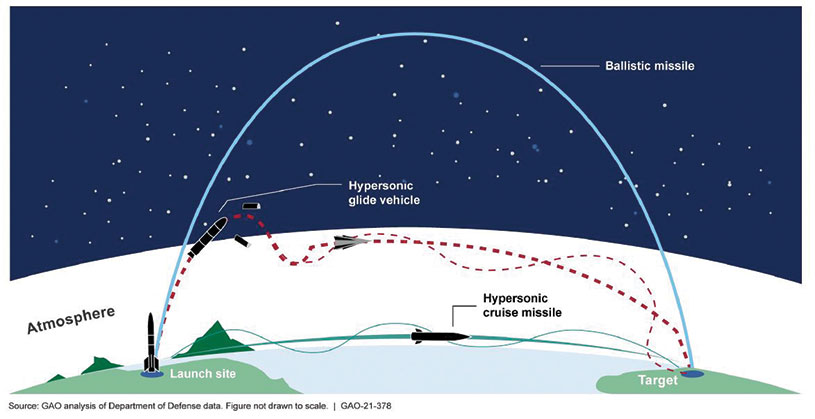
Diagram: U.S. General Accountability Office
BeiDou Enables Hypersonic Flight
In simulation drills using BeiDou, Chinese space scientists flew a hypersonic flight from Jinan, China, to New York over the Arctic Ocean, reports EurAsian Times. BeiDou facilitated contact between the command center on Earth and the hypersonic vehicle as it dodged enemy air defenses. Researchers claim using BeiDou provided a time lag of less than a second. They also claim to have optimized signal transmitters and designed new satellite-jumping methods to overcome communication challenges. China and Russia are the only countries with operational hypersonic weapons — Russia has used its Kinzhal hypersonic missile in the Ukraine war.
Indonesia’s National Research and Innovation Agency (BRIN) and Dr. Soetomo University are cooperating on aerial photo mapping using an unmanned aerial vehicle and GNSS hardware. BRIN’s Ocky Karna Radjasa said he expects that the two parties will extend the opportunity to advance research and innovation as well as bolster the quality of education in Indonesia. The university’s Nur Saidah expects BRIN’s support will increase, stating, “We still have limitation in laboratory facilities, so we seek industry cooperation. Let us hope that, as a result of this cooperation, we can receive help.”
A new navigation system addresses shortcomings of GNSS using cosmic-ray muons. Muometric navigation enables positioning underground, indoors or underwater within a reference coordinate system defined by the 3D positions of multiple detectors, researcher Hiroyuki K. M. Tanaka explains in the June issue of Nature. Tanaka’s work shows the system offers a navigation quality almost equivalent to aboveground GPS-based handheld navigation by determining the distance between the reference frame and the receivers with a precision of 1 to 10 meters.
In early August, the U.S. Government Accountability Office (GAO) released its third report in 15 months about GPS and other positioning, navigation and timing (PNT) issues within the Department of Defense (DOD). Each report raised raised concerns about the way in which PNT programs were being managed and led within the department.
Observations included that DOD continues to rely heavily on GPS despite known vulnerabilities. Also, that alternate PNT efforts are not well coordinated and receive little support.
“Opportunities” for DOD to improve its alternate PNT efforts, according to the report, include:
Improving coordination across the services
Clarifying authorities and responsibilities for prioritizing needs
Focusing on resiliency versus GPS as the cornerstone of department PNT efforts
Clarifying PNT requirements rather than just defaulting to GPS as “the need”
The report pointed out that M-code has been in development for 20+ years, and that GPS satellites have been capable of transmitting M-code signals since 2005. Also, while there are still program risks, the Next Generation Ground Control Segment, known as OCX, is forecast to be ready to support M-code use by 2023.
OCX has experienced severe cost overruns and is more than five years behind its original schedule. GAO issued a report on OCX delays in May 2019.
M-code won’t really be a capability in DOD, though, until user equipment is widely fielded. That will take several more years, according to GAO.
One of the remaining challenges to M-code implementation, GAO said, was that the department did not collect and validate all the data it needed for leadership planning and prioritization.
A summary on the first page of the report contains what could be seen as harsh criticism of how PNT efforts are led within DOD:
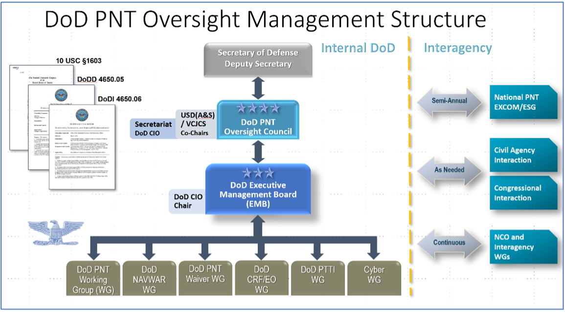
“DOD’s overall PNT portfolio is managed by the PNT Oversight Council, a statutorily established senior-level body. However, the Council has largely prioritized modernizing the existing GPS system over alternative PNT efforts during recent meetings and has no strategic objectives or metrics to measure progress on the alternative efforts.”
Image: DOD
Too Much Leadership?
Some believe the real problem with DOD PNT is not a lack of leadership, but rather too much.
“If everyone is in charge, no one is,” commented one retired senior military officer familiar with the issue.
“Congress has been concerned about DOD’s lack of attention to GPS and PNT alternatives for years,” the individual said. “In 2015 Congress mandated creation of the Oversight Council to help ensure PNT got the right amount of leadership attention.” This may have not had the desired effect, though.
“The council is comprised of three undersecretaries, the vice chairman [of the Joint Chiefs of Staff], four combatant commanders, the NSA [National Security Agency] director, DOD’s CIO [chief information officer], and host of other very senior folks. All of whom have way too many other duties. It’s no wonder the department has a hard time getting things done!”
The department’s CIO is the Defense Secretary’s Principal Staff Assistant for PNT. As such, the CIO is tasked with coordinating department-wide efforts. The task is made particularly difficult by the many and diverse players across the department, all of whom have their own authorities, interests and projects.
Proposed systems and capabilities are examined and developed by a variety of DOD organizations. These include laboratories belonging to the five services and the Defense Advanced Research Projects Agency (DARPA).
Programs of Record, which usually lead to acquisition of large systems, are led and managed within the individual services.
A Better Way?
Aside from recommending improved coordination of PNT efforts across the department, GAO has never addressed the way DOD manages its PNT enterprise.
“That is not something we normally get into unless specifically tasked,” said one of the reports’ authors. “We assume departments know best how to lead and manage their efforts.”
Others are not so reticent. They believe the current management structure is incapable of managing the development, acquisition and fielding of the DOD PNT Enterprise with any urgency or efficiency.
“GAO’s focus on the Oversight Council is misplaced,” one retired official asserted. “The missing piece is not oversight, it’s day-to-day DOD-wide management.”
“They need a multi-service program of record for resilient PNT,” the official said. “This would be separate from the GPS program, which would keep its own projects going and feed into the resilient effort. The new resilient PNT program should be managed by a Joint Program Office, which could consolidate integration and acquisition of resilient PNT applications. The office would be the steward for the critical technologies that underpin the modular, open-system integration strategy, including the digital reference architecture, input and output standards, software fusion engines, and needed modeling and simulation tools to ensure NAVWAR compliance.”
Such a construct could provide needed focus and coordination to DOD efforts, address many long-standing congressional concerns, and, by coordinating efforts within DOD and with industry, accelerate progress.
Dana A. Goward is President of the Resilient Navigation and Timing Foundation. He serves on the President’s National Space-based Positioning, Navigation, and Timing Advisory Board.