U.S. Air Force photo by Airman 1st Class Josie Kemp
The Swedish Defence Materiel Administration (FMV) signed a contract with navigation company iXblue for up to 172 FOG-based Quadrans gyrocompasses. The Quadrans navigation systems will be delivered over four years and will equip the Swedish Navy’s fleet of high speed crafts, mainly combat boats CB90.
“The FMV was seeking new maintenance-free and high-performance gyrocompasses for the retrofit of their fleet of high speed crafts,” said David Cunningham, commercial director at iXblue. “The CB90 vessels are indeed very fast boats and need the most reliable and accurate heading and attitude data to navigate safely. With our Marins Series Inertial Navigation Systems being already in service on the Gotland-class submarines and Koster Class MCMV’s, and our Quadrans gyrocompasses equipping other surface boats in the Swedish Navy fleet, the FMV was familiar with the high-performance delivered by our systems and knew the Quadrans met the specific requirements needed for the CB90.”
The Quadrans gyrocompasses are build around iXblue’s Fiber-Optic Gyroscope technology. According to the company, the gyrocompasses provide highly accurate heading and attitude data and are perfectly suited for high performance at high speeds and in challenging environments such as GNSS-denied settings.
In addition, the Quadrans Gyrocompasses are compact, lightweight and with low power consumption. They’re easy to install on small-sized crafts, while their open architecture guarantees seamless interfacing with all major GNSS systems and third-party navigation software, iXblue added.
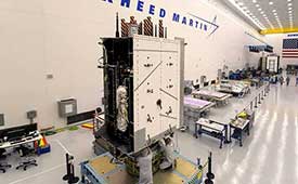
The United States Space Force’s GPS III program reached another milestone with the successful core mate of GPS III Space Vehicle 08 at Lockheed Martin’s GPS III Processing Facility in Waterton, Colorado, April 15.
With core mate complete, the space vehicle was named in honor of NASA trailblazer and “hidden figure” Katherine Johnson.
The two-day core mate consisted of using a 10-ton crane to lift and complete a 90-degree rotation of the satellite’s system module, and then slowly lowering the system module onto the satellite’s vertical propulsion core. The two mated major subsystems come together to form an assembled GPS III space vehicle.
Despite the COVID-19 pandemic, the Space and Missile Systems Center (SMC) and its mission partner Lockheed Martin ensured that SV08 core mate took place, in accordance with all Centers for Disease Control and local guidelines to minimize exposure or transmission of COVID-19. The GPS III Processing Facility’s cleanroom high bay was restricted to only key personnel directly supporting the operation.
“Core mate is the most critical of the GPS space vehicle single-line-flow operations,” said Lt. Col. Margaret Sullivan, program manager and materiel lead for the GPS III program. “Despite the restrictions presented by the COVID-19 pandemic, our team adapted and worked tirelessly to achieve this essential milestone.”
Katherine Johnson. (Photo: NASA)
Katherine Johnson. When the core mate operation is successfully completed, a GPS III satellite is said to be “born.” In keeping with the team’s tradition of naming GPS III satellites after famous explorers and pioneers, SV08 was named “Katherine Johnson” in honor of the trailblazing NASA mathematician and “human computer” who designed and computed orbital trajectories for NASA’s Mercury, Apollo and space shuttle missions.
One of four African-American women at the center of the nonfiction book by Margot Lee Shetterly and the movie Hidden Figures, Johnson was awarded the Presidential Medal of Freedom in 2015 for her groundbreaking contributions to the U.S. space program.
Other GPS III satellites have been named in honor of explorers including GPS III SV01 “Vespucci” after Amerigo Vespucci; GPS III SV02 “Magellan” after Ferdinand Magellan; and GPS III SV03 “Columbus” after Christopher Columbus.
Next up, performance tests. The next step for the newly christened “Katherine Johnson” is the post-mate Systems Performance Test (SPT) scheduled to begin in August. SPT electrically tests the performance of the satellite during the early phase of build and provides a baseline test data set to be compared to post-environmental test data.
GPS III SV08 is currently scheduled to launch in 2022.
The Mobile Service Tower rolls back from the ULA Delta IV rocket carrying the GPS III SV02 satellite in preparation for launch. (Photo: ULA)
GPS III is the most powerful GPS satellite ever developed. It is three times more accurate and provides up to eight times improved anti-jamming capability over previous GPS satellites on orbit. GPS III brings new capabilities to users as a fourth civilian signal (L1C), designed to enable interoperability between GPS and international satellite navigation systems, such as Europe’s Galileo system.
GPS III satellites will also bring the full capability of the Military Code (M-code) signal, increasing anti-jam resiliency in support of the warfighter. These continued improvements and advancements to the GPS system makes it the premier space-based provider of positioning, navigation, and timing services for more than four billion worldwide.
GPS III SV03 is scheduled to launch on June 30.. (Photo: Lockheed Martin)
GPS III SV03 to Launch June 30. Launched in December 2018 and August 2019, GPS III SV01 and SV02 became part of today’s operational constellation of 31 satellites, on January 13 and April 1, 2020 respectively. GPS III SV03 is scheduled to launch on June 30.
The SMC, located at the Los Angeles Air Force Base, California, is the center of excellence for acquiring and developing military space systems. Its portfolio includes the GPS, military satellite communications, defense meteorological satellites, space launch and range systems, satellite control networks, space based infrared systems, and space situational awareness capabilities.
Orolia and Seven Solutions have partnered to deliver resilient, accurate, and stable time and frequency for global military, commercial and critical infrastructure applications.
According to the companies, the partnership will address the ultra-precise, resilient timing and frequency requirements of industries such as defense, aerospace, data centers, telecom, financial services, smart grids and other critical infrastructure.
Through the partnership, Orolia will offer a modular approach to resilient PNT, which includes a combination of GNSS signals protected with interference detection and mitigation technology, together with low Earth orbit secure alternative signals. The Orolia-Seven Solutions partnership also will offer terrestrial sub-nanosecond time distribution from distant and potentially redundant locations.
“This partnership is a key example of Orolia’s commitment to combining best-in-class technologies into more robust resilient PNT solutions for our customers,” said Orolia CEO Jean-Yves Courtois. “Those who require the most accurate, extremely precise time and frequency technology will now also benefit from an unprecedented level of resilience to protect critical PNT data sources, for more confidence and peace of mind.”
This new partnership between Seven Solutions and Orolia will facilitate global operations and naturally integrate with reliable time sources. Seven Solutions will focus on bringing the best-in-class time and frequency distribution, the companies said.
The technology multinational GMV has won a contract under the Spanish Ministry of Defense’s (MoD’s) RAPAZ program for the supply of four Class I Seeker RPASs to be integrated into the intelligence units of the Paratrooper Brigade and the Tercio de Armada de Infantería de Marina (Marine Infantry Protection Force).
The contract will provide the armed forces with the most advanced version of the unmanned aircraft Seeker.
The UAS Seeker is an autonomous, rapid-deployment system developed by Aurea Avionics and supplied by GMV. It provides intelligence, surveillance and reconnaissance capabilities over a 15-kilometer range with a 90-minute endurance and a weight of 3.5 kg.
The aircraft will strengthen the intelligence, surveillance and reconnaissance capabilities of Spanish troops, ensuring better operational capability and tactical superiority.
Seeker constitutes the core of a situational awareness system, providing real-time intelligence. It is designed for rapid-deployment and high-mobility military applications carrying out low-level intelligence, surveillance and reconnaissance tasks.
The system components can be broken down into two major groups: the air segment and the ground segment. The air segment comprises the unmanned aerial system (UAV), fit for daytime and nighttime operations and capable of completely autonomous flying. The ground segment comprises a ground control station, a ground data terminal, and a remote handheld control. These systems between them monitor the UAV’s operation and process its real-time video data.
Within this project, due for delivery by October 2020, GMV will be running the design and manufacturing activities and also the various flight campaigns scheduled to check that the systems work properly before handover to the MoD.
GMV developments for unmanned aircraft
GMV boasts great expertise and experience in Unmanned Aerial Systems (UAS), built up on the strength of many previous projects such as ATLANTE, where it developed the aircraft’s flight control computer; EGNSS4RPAS, where it weighed up EGNOS performance for RPAS operations; and DOMUS, where it developed emergency-management and -monitoring service demonstrators for drone traffic control under the U-Space system.
This Spanish MoD Seeker system supply contract boosts GMV’s growing renown as developer and supplier of UAV systems and services.
The U.S. Department of Homeland Security (DHS) issued a report on alternative sources of PNT on May 6. It was submitted to U.S. congressional committee leaders on April 8.
Section 1618 of the 2017 National Defense Authorization Act (NDAA) of Dec. 23, 2016, required the DHS to address the need for a GPS backup by identifying and assessing viable alternate technologies and systems.
The report is a summary and analysis of that assessment by the Homeland Security Operational Analysis Center (HSOAC) of PNT systems currently used by critical infrastructure. It also provides recommendations for the federal government’s next steps to increase the resilience of critical infrastructure to disruption of GPS services.
In the report, DHS offers the following recommendations to address the nation’s PNT requirements and backup or complementary capability gaps:
Temporary GPS disruptions: End users should be responsible for mitigating temporary GPS disruptions. For example, the Federal Aviation Administration maintains sufficient PNT capabilities to assure the continued safe operation of the national airspace, albeit at a reduced capacity, during GPS disruptions. The federal government can facilitate this mitigation for various critical infrastructure sectors, but should not be solely responsible for it.
PNT Diversity and Segmentation: The federal government should encourage adoption of multiple PNT sources, thus expanding the availability of PNT services based on market drivers. Encouraging critical infrastructure owners and operators to adopt multiple PNT systems will diffuse the risk currently concentrated in wide-area PNT services such as GPS. Federal actions should focus on facilitating the availability and adoption of PNT sources in the open market.
System Design: PNT provisioning systems, assets, and services must be designed with inherent security and resilience features. Critical infrastructure systems that use PNT services must be designed to operate through interference and to identify and respond to anomalous PNT inputs. These attributes are applicable to the PNT receivers and the systems that use them.
Pursue Innovation that Emphasizes Transition and Adoption: Incorporating PNT signal diversity into the PNT ecosystem should be pursued with an emphasis on research and development that prioritizes successful transition and adoption into existing GPS receivers, taking into account factors such as business case considerations, financial costs, technical integration, and logistical deployment.
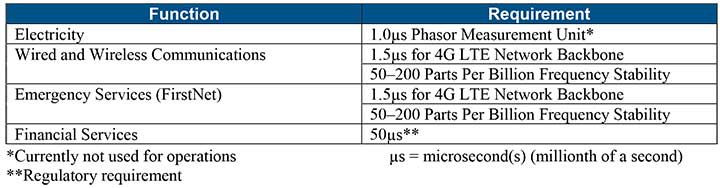
Table 1 shows timing requirements for critical infrastructure are, according to the report.
Table 1. (Image: DHS report)
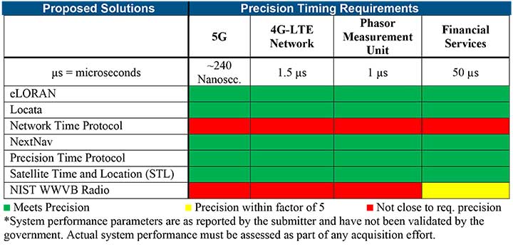
Table 2 from the report shows proposed timing solutions submitted by industry to DHS during a Request for Information (RFI) in December 2018. Systems that can meet or exceed timing requirements for critical infrastructure are indicated in green.
Table 2 (Image: DHS report)
Satelles responds
The Satelles company, which offers STL, issued a statement on the report. “This important report highlights the urgent need for GPS backup for critical applications, and it identifies and characterizes a variety of solutions that are available to meet this need today,” said Michael O’Connor, CEO of Satelles. “The report also describes the essential role of the federal government in urging industry to implement multiple technologies, without making the mistake of providing or selecting a single PNT solution.”
Continued O’Connor, “DHS goes on to define a baseline requirement for timing services accuracy for critical infrastructure. Not only does Satelles meet or exceed the precision timing specifications stated by DHS, but also our solution provides national coverage (including Alaska, Hawaii, and U.S. territories) and is commercially available now.”
Orolia has introduced a low SWaP-C miniaturized rubidium oscillator, the Spectratime mRO-50, designed to meet the latest commercial, military and aerospace requirements where time stability and power consumption are critical. The oscillator is low SWaP-C — size, weight, power and cost.
The Spectratime mRO-50 provides a one-day holdover below 1 µs and a retrace below 1 x 10⁻¹⁰ in a form factor sized 50.8 x 50.8 x 19.5 millimeters. It takes up only 51 cc of volume — about one-third of volume compared to standard rubidiums — and consumes only 0.45 W of power.
he Spectratime mRO-50 miniaturized rubidium oscillator provides accurate frequency and precise time synchronization to mobile applications, such as military radio-pack systems in GNSS-denied environments. Its operating temperature of -10°C to 60°C (military version extends to -40°C to 75°C) is also suitable for UAVs and underwater applications.
Orolia is a leader in space-based atomic clocks and high-end crystal, rubidium, hydrogen maser and integrated GPS/GNSS clocks. The company also provides testing instruments for space missions that rely on high precision atomic clock technology.
Orolia’s Atomic Clocks team received the 2019 PTTI Distinguished Service Award in January for advancing the state of the art in high-stability atomic clocks and producing the only space-based passive H-maser in the world, operating on all Galileo satellites. Spectratime mRO-50 is the latest technology solution from this award-winning team.
“Through Orolia’s continuous commitment to innovation, we are proud to offer our customers more precise PNT data in a cutting-edge, lightweight form factor for mobile missions,” said Orolia’s Atomic Clocks Product Line Director, Jean-Charles Chen.
By Airman 1st Class Jonathan Whitely, 50th Space Wing Public Affairs
News from Schriever Air Force Base
The 2nd Space Operations Squadron performed the first station keeping maneuver on a GPS III satellite to Satellite Vehicle Number 75 on May 14 at the Schriever Air Force Base in Colorado.
The maneuver set a new standard for how GPS maneuvers should be conducted for the squadron that provides precision, navigation and timing signals to billions of users around the world.
A station keeping maneuver is performed to keep vehicles in their node (or parking spots in orbit) and involves burning the satellite’s thrusters and changing the vehicles speed at a particular point in its orbit. This causes the orbit to change, in turn, keeping the vehicle in the ideal position to provide coverage.
“All operational GPS vehicles are assigned nodes, when all nodes are filled with healthy vehicles there is good global GPS coverage,” said 1st Lt. Michael Gallagher, GPS subsystems analyst. “When new vehicles are launched they typically aren’t launched directly into their final node. This means that the 2 SOPS analysis flight must perform a re-phase maneuver to put a vehicle in its node.”
The maneuver required GPS III’s signal to be turned off. Turning off the navigation signal while performing the maneuver prevents users from receiving inaccuracies generated by a change in satellite velocity.
“This was a new process that we could learn from as it was the first station keeping [maneuver] performed for the newest generation of GPS satellites,” said Senior Airman Harrison Sherwood, 2 SOPS satellite systems operator, who sent the commands to the satellite during the maneuver. “[Since] this was the first [maneuver] of the newest generation satellites, it was a bit of a guinea pig for future maneuvers.”
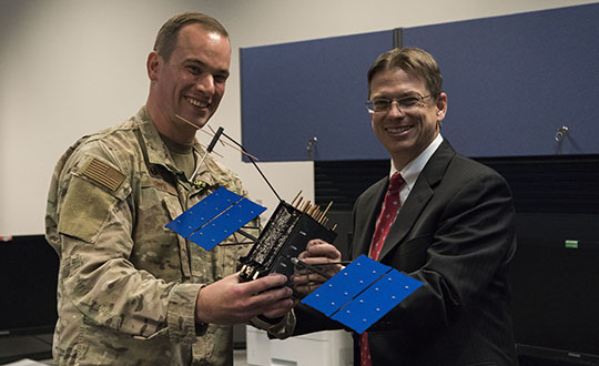
Johnathon Caldwell, Lockheed Martin Space vice president of navigation systems, right, presents Lt. Col. Stephen Toth, 2nd Space Operations Squadron commander, with a GPS III model satellite as a token of appreciation for the 2nd SOPS critical mission in space at Schriever Air Force Base, Colorado, July 29, 2019. The squadron performed its first station keeping maneuver on a GPS III satellite May 14, 2020, at Schriever AFB. (Photo: U.S. Air Force/1st Class Jonathan Whitely)
However, the unit was able to complete the maneuver flawlessly. The maneuver was completed in a special mission area and there were no changes to the normal operations floor.
“This maneuver had no effect on the rest of the [GPS satellite] constellation,” Gallagher said. “SVN-45 was in the node SVN-75 was being placed into, so there was no decrease in GPS signal quality as a result of this maneuver.”
This procedure was also the first of its kind to be performed with the 2nd SOPS Architecture Evolution Plan, which all active satellites in the program are operated. Since GPS III vehicles are fully integrated into the program with this maneuver, all maintenance is conducted through AEP.
“Station keeping maneuvers are essential to satellite operations and must be done for regular maintenance,” said 2nd Lt. Tyler Gorman, 2nd SOPS navigation payload engineer. “This activity helped validate a nominal maintenance activity for a new generation of vehicles.”
The unit plans to continue to use this new method and program for future GPS satellites that are being launched and need to be re-phased into their operation slots. The next satellite that will need a station maneuver performed is SVN-76, which is scheduled to launch in the next few months.
“GPS maintenance requires a coordinated effort to ensure our worldwide service is preserved,” Gorman said. “That means careful planning and execution from our analysts in 2 SOPS, our satellite system operator and the operational support from Lockheed Martin and the Aerospace Corporation.”
Honeywell has been granted a four-year, $99 million contract to help the U.S. Air Force for the embedded GPS and inertial navigation systems (INS) modernization program (EGI-M). Honeywell will provide engineering, manufacturing and development services to the EGI-M program under the sole-source contract, according to the Department of Defense.
Work will be performed in Clearwater, Florida, through April 19, 2024.
The contract is the result of a sole-source acquisition and only one offer was received. The Air Force Life Cycle Management Center, Position, Navigation & Timing Contracting Branch, Robins Air Force Base, Georgia, is the contracting activity (FA8576-20-C-0001).
U.S. Federal Communications Commission (FCC) Chairman Ajit V. Pai has responded to a congressional letter expressing objections to the April 20 FCC decision to allow Ligado to establish a broadband network.
In a May 27 email sent to GPS World, the FCC wrote, “Given your interest in the Ligado order that the Commission adopted unanimously last month, we wanted to share with you the text of the letter Chairman Pai recently sent to members of Congress on this topic.”
The five-member FCC voted unanimously in April to approve an order to allow Ligado Networks to deploy a low-power nationwide 5G network. Experts and policy makers have said the broadband network could — or likely would — interfere with reception of GPS signals.
On May 7, a bipartisan group of 23 members of the House Armed Services Committee (HASC) sent a letter to the FCC questioning the decision, and this is the letter the FCC is now responding to.
The letter from Committee Chairman Adam Smith (D-Wash.) and Ranking Member Mac Thornberry (R-Texas) says the FCC order did not comply with Section 1698 of the National Defense Authorization Act for Fiscal Year 2017. That act prevents the commission from approving commercial terrestrial operations in certain portions of the L-band spectrum until 90 days after the commission resolves concerns of harmful interference to GPS devices.
The Senate Armed Services Committee held a hearing on the topic on May 6 with Department of Defense officials, and on May 15, 32 senators asked the FCC to address their concerns and stay the Ligado approval order while doing so.
“GPS has no right to operate in the spectrum in question, so there is nothing for Ligado to share.” — FCC Chairman Pai
The letter insists that GPS will remain protected. “Although your letter references the shared use of spectrum, the Commission’s L-band decision does not authorize any spectrum sharing between Ligado and GPS. In fact, spectrum in this band has been licensed to Ligado and predecessor companies for over 30 years — with those companies authorized to deploy terrestrially since 2004. And as mentioned above, one of the FCC’s conditions require separation of Ligado’s operations from GPS spectrum by means of a 23-megahertz guard band. Thus, any implication that the Commission has authorized Ligado to “share” spectrum that is currently allocated to GPS is incorrect. GPS has no right to operate in the spectrum in question, so there is nothing for Ligado to share.”
Download the full letter to Rep. Smith here. Download HASC letter to the FCC here.
The email to GPS World included the following statement: “The FCC is required by law to make its decision based on the facts in the record, and federal agencies, including the Department of Defense, were provided with multiple opportunities to put whatever facts they believed to be relevant into the record, including classified information, which the Commission has a process in place to protect.
“The Commission based its decision on all of the information in the record. Moreover, we are not aware of the FCC refusing any request by the Department of Defense to provide a briefing related to this matter.
“To the extent any federal agency opposed to the Ligado application chose not to share information with the Commission, that was the agency’s decision and suggests that it did not believe that the information in question would bolster its case.”
There’s no question that GPS is an essential service. The Second Space Operations Squadron (2 SOPS) is continuing to provide a global utility during the COVID-19 pandemic.
“No matter what, we need to ensure this mission continues so the American people and the world know they can depend on us to be the gold standard in precision navigation and timing,” said Lt. Col Stephen Toth, 2 SOPS commander. Services that use GPS include ambulances, hospitals, police departments and fire departments.
“It would make a global pandemic that much worse if we were to go down,” Toth said. “It could prevent a lot of the day-to-day things we rely on from happening, it could be catastrophic.”
GPS supports 14 of 16 essential industries in the United States. “We’ll remain reliable no matter what the condition the world is in,” Toth said. “Whether it be a pandemic, hurricane, tornado or any other type of crisis, we have plans and training for whatever threat we may face so the mission doesn’t stop.”
Unlike other jobs across the Department of Defense, those directly conducting operations can’t telework. They need to be in a sensitive compartmented information facility or restricted area in a secured area to access specific terminals and networks.
“The American people can count on space and they can count on our military to continue to provide the level of capability that’s expected no matter what’s going on in the world,” Toth said. “In times of crisis, people shouldn’t have to question whether we’ll be here or not, because we will and the mission won’t stop.”
Welcome to the Space Force
The official Space Force emblem was unveiled on Jan. 24.
Organized as a military service branch within the U.S. Department of the Air Force, the newly created Space Force has taken the reins of the GPS program.
Established on Dec. 20, 2019, under the Fiscal Year 2020 National Defense Authorization Act, the Space Force will be set up over the following 18 months. Commander of U.S. Space Command, Gen. John “Jay” Raymond, was sworn in Jan. 14 as the first chief of space operations of the U.S. Space Force, and is stationed at the Pentagon.
The same staff who have operated satellites and conducted space activities in the Air Force are continuing under the Space Force. Under the Space Force are the Space and Missile Systems Center at Los Angeles Air Force Base and the GPS Master Control Station, operated by the 50th Space Wing’s 2nd Space Operations Squadron (2 SOPS) at Schriever Air Force Base, Colorado. The 50th Space Wing is under Space Operations Command, located at Vandenberg Air Force Base, California.
25 years. The U.S. Space Force celebrated the 25th Anniversary of GPS reaching Full Operational Capability (FOC) on April 27, 2019. Over the past 25 years, GPS has become an integral technology that affects the lives of billions of people across the world.
Check out more case studies where GPS and inertial technology are supporting defense missions.
Featured image: U.S. Space Force / Kathryn Calvert; Capt. Jeff Wagner discusses a routine health check on a GPS satellite. 2 SOPS performs the command and control mission for the constellation.
In the United States, trucking companies and the Army are both developing systems to automate moving groups of trucks. While trucking companies are mostly interested in “platoons” of trucks drafting off of each other to save fuel, the Army wants its “convoyed” trucks to be hundreds of meters apart to improve their chances of surviving an enemy attack.
Battlefield challenges
While the biggest danger for platoons of commercial trucks is crashing, military convoys can be threatened by attacks with improvised explosive devices (IEDs) or rocket-propelled grenades.
Civilian truck drivers also benefit from a robust infrastructure, said Bernard Theisen, division chief for Ground Vehicle Robotics at the U.S. Army’s Ground Vehicles Systems Center (GVSC). For example, nearly all platooning trucks are limited to using roads and highways that have been mapped at centimeter-level resolution with lidar, can communicate over 3G or 4G networks, and have excellent GNSS signals. “I would love to have all that information,” Theisen said, “every time I send a robotic convoy vehicle out there.”
By contrast, the military must design a system that assumes “no comms, no prior data, and no infrastructure,” Theisen explained. “Sometimes a bridge that used to be there has been blown up or we may have put a new bridge across the water overnight. A building that was there yesterday got blown up and is now blocking the road. You cannot pre-plan that in the map and expect it not to change.”
Nevertheless, the civilian and military efforts share some challenges, Theisen acknowledged, including “perceiving the world, understanding it, processing the data, and making the right decisions.” Unlike robots, humans are very good at coping with the unexpected. “You can only train a robot so much, there will always be situations that it does not know how to handle.”
In a military convoy, every fourth or fifth truck may have a mounted gun to protect the convoy. The convoy will typically include one or more ambulances, wreckers and fuel tankers. “It is a different application than for Amazon or FedEx to send a couple of trucks down the highway,” Theisen said.
Leader-follower
In leader-follower applications, GVSC installs the same hardware on all its trucks. “This facilitates software maintenance, because you don’t need to have different versions,” Theisen said. If the convoy’s leader is disabled from a mechanical or battlefield issue, it is easy for a soldier on the next truck to authorize his truck to take over as the convoy’s new leader. “We have also created cases where the leader takes that road months ahead of the followers,” said Alberto Lacaze, co-founder and president of Robotic Research. “So, the leader does not need to be a part of the convoy.”
Rough terrain doesn’t affect navigation, except that in hilly terrain trucks might have more side-to-side drift than in a flat area. “We often use a three-axis IMU [inertial measurement unit] instead of a two-axis IMU, which might be all you need for a commercial application on flat roads,” Theisen said.
“The commercial problem is almost like carrying a group of trailers that are not mechanically connected,” Lacaze said. It is crucial to be able to tie in the vehicles’ low-level controls so that they maintain a very short separation. If those vehicles were trying too hard to maintain those very close distances by frequently accelerating and decelerating, the fuel-savings advantages from drafting would go away. By contrast, for military applications the exact distance between the trucks doesn’t matter much, but their side-to-side error does. “You would like all vehicles to be driving within one tire width of the lead vehicle’s tracks,” Lacaze said. “That has many advantages — for example, if that road has been demined.”
While commercial and military software largely overlap, their sensor requirements are fundamentally different. “Most commercial vehicles are not checking to see whether there is a crater in the middle of the road,” Lacaze said. Military vehicles need to detect such damage to the infrastructure and respond quickly.
Still, the military is interested in “the gigantic amount of mapping of the available infrastructure” being done by private companies, Lacaze said, because most military convoys are not in war-torn areas, but delivering materiel to bases in areas with some infrastructure.
Robotic modes
GVSC purchases commercial off-the-shelf (COTS) systems and integrates them into its trucks, Theisen explained, producing five robotic modes:
Warning, which consists of “idiot lights” and buzzers alerting human drivers that, for example, they are straying out of a lane or are about to hit something
Driver assist mode, which helps drivers brake, accelerate and steer
Teleoperation, which consists of driving the truck from a remote location
Waypoint navigation, which uses a GNSS waypoint path that can either be pre-programmed or pre-driven and then replayed
Leader-follower, in which the first vehicle leads and potentially any number of vehicles follow.
Regarding the driver assist mode, Theisen pointed out that “all these features are very common in high-end cars and you are seeing them coming into many Class 8 trucks. We don’t do any development in the Army from that standpoint.” Regarding the leader-follower mode, the first truck can be driven in any of the other four modes.
GVSC is the lead system integrator for 30 robotic palletized loading systems (PLSs) that the Army has at Fort Polk, Louisiana, and another 30 at Fort Sill, Oklahoma. Nevertheless, a human driver usually leads the robotic convoy. The driver determines the best route, assesses the situation, and is normally followed by three unmanned systems. “That is why we call our system semi-autonomous,” Theisen said.
The role of GNSS
The Olli shuttle, equipped with Robotic Research’s AutoDrive kit, is deployed on busy boardwalks, campuses and public roads. (Photo: Robotic Research)
For both commercial platooning and military convoying, GNSS signals are used for redundancy but not as the primary source of measurement of the distance between the trucks. “None of the systems that we have deployed on the commercial side — for example, with Local Motors vehicles (the Olli shuttle) — rely on GNSS,” Lacaze said, though they will use those signals if available. The high accuracy of their inertial systems make it hard to spoof or jam GNSS receivers, because the system would detect any changes in the GNSS solution and the vehicles would continue running on inertial navigation if the GNSS signal were jammed.
“We assume that we will not have GNSS information because sometimes we are jamming ourselves or are being jammed or the enemy could be spoofing us,” Theisen said. Most of GVSC’s systems use “nav boxes” sold by multiple vendors that enable vehicles to navigate for long periods without GNSS signals. They typically combine one or two GNSS receivers, an IMU or several smaller ones, a combination of wheel encoders or ground sensors to determine ground speed, and a digital compass.
GVSC’s trucks also use lidar to generate voxel maps of their current surroundings, and then share them with the other trucks in the convoy. Each vehicle tracks the vehicle in front of it and can just follow it, if it has insufficient position information or good visual cues.
GVSC looks for the highest possible GNSS accuracy, whether using civilian GNSS receivers or military Selective Availability Anti-Spoofing Module (SAASM) units. “We also take advantage of the future M-code,” Theisen said. “We do have capabilities that the civilian marketplace does not have.”
Remaining obstacles
The remaining bottleneck in the development and implementation of convoys of autonomous military vehicles is the approval process, Lacaze said. “Currently, if we make changes to the autonomy systems, the testing parts of the government are asking us to drive hundreds of thousands of miles before providing approvals. It is still a challenge to figure out at what point these vehicles are safe enough to provide to the soldiers and what the cost of doing so is.”
For these systems to take off, better processors, sensors (cameras, radars and lidars) and algorithms are required, Theisen said. “There is way more sensor data that you can collect and process in real time.”
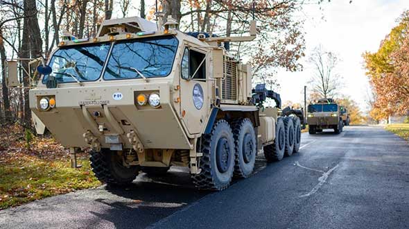
Featured photo, provided by Robotic Research: Army convoys can stretch for miles. The U.S. Army’s Autonomous Ground Resupply trucks shown here are connected with Robotic Research’s autonomous technology.
Emcore is offering two inertial measurement units (IMUs) suitable for the defense market.
SDI500 Tactical Grade IMU. Emcore’s Systron Donner Inertial SDI500 is a high-performance MEMS-based IMU that demonstrates true tactical grade performance with 1°/hour gyro bias and 1-mg accelerometer bias stability with very low 0.02°/hr angle random walk. Its performance is based on Emcore’s quartz MEMS inertial sensor technology. The SDI500 is designed to achieve the demanding performance levels required in sophisticated systems applications. Packaged in a highly miniaturized, cylindrical configuration with a volume of 19 cubic inches, it is suitable for use by integrators and OEMs.
The SDI500 is a compact IMU constructed with SDI’s next generation quartz gyros, quartz accelerometers, and high-speed signal processing that achieves tactical grade performance. The SDI500 IMU is rated for rugged military environments.
EN-300 Precision Fiber Optic IMU/INS. The EN-300 inertial system is designed to be compatible in form, fit and function with a legacy equivalent, but with the higher accuracy and performance needed for GPS-denied navigation, precise targeting and line-of-sight stabilization.
It features navigational-grade performance with 0.04°/hr gyro bias and 0.1-mg accelerometer bias stability with ultra-low 0.007°/hr angle random walk.
Internal signal processing provides full stand-alone or aided navigation, and as an option can provide standard IMU delta velocity and delta theta.