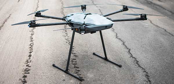
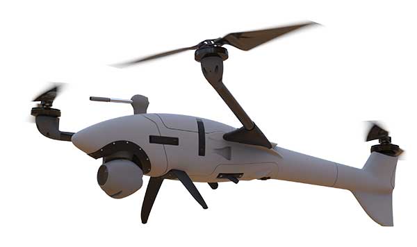
DroneHunter F700 is a radar-based autonomous interceptor drone for tracking and stopping dangerous drones
Fortem Technologies Inc. is now shipping its artificial intelligence (AI)-enabled F700 DroneHunter. The F700 is a safe, effective deterrent against a rising number of careless and criminal drones, the company said.
The F700 has a flexible undercarriage that offers interchangeable counter measures for single, multiple or swarm-based threats. Its new lightweight carbon-fiber frame enables greater athleticism and speed.
The F700 can carry multiple types of anti-drone countermeasures and deploy them in real-time, based on the dynamic threat detected miles beyond the protected area. The undercarriage features pogo pins and payload snaps integrated with AI-enabled firing and flight software.
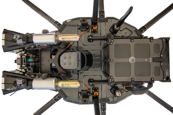
Underside of the DroneHunter F700. (Photo: Fortem Technologies)Photo:
The F700 offers significant payload capacity to handle situations over civilians where zero collateral damage is required. AI decisions are now made in real-time to select the appropriate effectors for the detected threat. Complex algorithms for flying in urban areas are now supported. Heavier drones are tethered or parachuted with controlled descent into predetermined safe zones.
The F700 is equipped with ground- and airborne-networked radar and corresponding optics, giving users total situational awareness and autonomous precision. F700 is custom designed and manufactured in the United States.
“We have advanced the DroneHunter F700 so that it can deliver any ordinance necessary to stop drones and to protect stadiums, refineries, campuses and entire metro regions,” said Fortem Technologies CEO, Timothy Bean.
Fortem is developing several DroneHunter mitigation types, including directed energy.
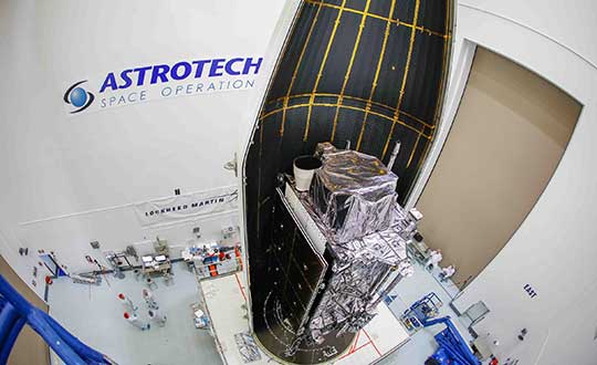
The second GPS III satellite, nicknamed Magellan, has been designated healthy and usable.
According to a Notice of Advisory to Navstar Users (NANU) issued by the U.S. Coast Guard, the satellite has been designated usable as of April 1, 1945 ZULU.
The 2nd Space Operations Squadron (2 SOPS) accepted control of the Magellan on March 27 at the Schriever Air Force Base in Colorado.
Designated Satellite Vehicle Number 75 (SVN75) in the GPS constellation, Magellan is the second GPS III satellite to be accepted into the program, and the first to be accepted during a global pandemic.
The second GPS III satellite is encapsulated before launch. (Photo: Lockheed Martin)
“We’re continuing to make major strides even while working through this pandemic, and we continue to expand our capability to further the program along,” said Lt. Col Stephen Toth, 2 SOPS commander. “This is a huge, momentous occasion for us, that we’re reaching this milestone, that our programs are being delivered, that they’re being executed and the systems are performing as expected. Ultimately, we’re all very excited that we’ve accomplished this major milestone in the program’s history, and we’re very excited for the next things to come.”
The new generation of GPS III vehicles have a 15-year design life and signals that are three times more accurate than the current generation.
“[This means users will have] better accuracy anywhere in the world, with a user’s device being able to determine their location more reliably,” said Capt. Ryan Thompson, 2nd SOPS assistant director of operations.
Additionally, the new satellites have eight times improved anti-jam capability, allowing the military warfighter to operate better in contested, degraded and operationally limited environments.
The vehicles are designed to be forward and backward compatible, which allows them to adapt to the future while remaining fully adaptable to the previous generation of vehicles.
Eight more GPS III satellites are scheduled to launch from now until 2025.
Despite any challenges that may arise, 2nd SOPS remains focused on the mission and continues to make history in space.
“As we’ve moved forward into the Space Force, we’ve taken a bigger mindset approach toward being warfighters,” Toth said. “What COVID has actually brought out of us is the full understanding of what it is to operate with a warfighter mindset. We may not be at war with an enemy per say, but we are definitely at war with the virus. My job is to ensure we continue to provide position, navigation and timing to the world. And we take that very seriously, so despite the virus, we’ll ensure that our mission continues.”
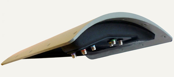
GPS IIIF’s M-code can be broadcast from a high-gain directional antenna in a concentrated, high-powered spot beam, in addition to a wide-angle, full-Earth antenna. (Artist rendering: Lockheed Martin)
U.S. Space Force, Lockheed Martin upgrade Operational Control System (OCS) and refresh GPS constellation with new satellites.
The final steps to fully enable the ultra-secure, jam-resistant military code (M-code) signal on GPS are now underway.
As part of the U.S. military’s effort to modernize GPS, the U.S. Space Force has been steadily upgrading its existing GPS Ground Operational Control System (OCS). The Space Force recently announced Operational Acceptance of the GPS Contingency Operations (COps) upgrade, developed by Lockheed Martin.
The Space Force’s M-Code Early Use (MCEU) upgrade, delivered earlier this year, will enable the OCS to task, upload and monitor M-code within the GPS constellation, as well as support testing and fielding of modernized user equipment, prior to the completion of the next-generation ground control systems.
This spring, work will begin to install the components needed to command and monitor the M-Code encrypted GPS signal, which enhances anti-jamming and protection from spoofing, as well as increases secure access for our forces, into the GPS OCS. M-code signals are available on all the on-orbit GPS IIR-M, IIF and III space vehicles.
A key to enabling M-code is a new software-defined receiver Lockheed Martin developed and is installing at all six Space Force monitoring sites. The M-code Monitor Station Technology Capability (M-MSTIC) uses a commercial, off-the-shelf general purpose graphics processing unit (GPU) to cost effectively receive and monitor M-code signals. Operators can monitor the signal as needed. M-MSTIC complements MSTIC’s, which Lockheed Martin developed and fielded to replace aging hardware receivers that were becoming difficult and expensive to maintain.
“Our warfighters depend on GPS signals every day for many critical missions, so anything we can do to make these signals more resistant to jamming and spoofing is extremely important — and available today,” said Johnathon Caldwell, Lockheed Martin vice president of Navigation Systems. “The more powerful GPS III/IIIF satellites coupled with Lockheed Martin’s upgrades to the GPS ground system are making that possible.”
GPS III also provides a new L1C civil signal, compatible with other international GNSS, such as Europe’s Galileo.
Lockheed Martin is contracted to build up to 32 GPS III/GPS III Follow On (GPS IIIF) satellites to help modernize the GPS constellation with new technology and advanced capabilities. The delivery tempo for these modernized GPS satellites will allow for several launches per year. The third M-code enabled GPS III satellite, named “Columbus,” is expected to launch in April, 2020.
Red Dragon Cybersecurity Suite
Cyber defenses across the upgraded GPS system were recently evaluated by a government assessment team and passed the Operational Utility Evaluation. Lockheed Martin delivered the Red Dragon Cybersecurity Suite (RDCSS) Phase III upgrade during the fourth quarter of 2019, dramatically improving Defensive Cyber Operations (DCO) visibility into GPS network traffic.
Other add-ons include user behavior analytics to analyze patterns of traffic and network taps to improve data collections.
“GPS is an attractive target for our adversaries, so it was critical we bring our best cybersecurity defenses to the table,” said Stacy Kubicek, vice president of Mission Solutions Defense and Security. “Since we began sustaining the Ground OCS in 2013, we have systematically upgraded and replaced software and hardware — it’s now a very secure system.”
Lockheed Martin has sustained the GPS Ground OCS since 2013. In November of 2018, the team completed the AEP 7.5 architectural change – replacing the hardware and software to improve resiliency and cybersecurity. In December of 2018, the Air Force awarded Lockheed martin the GPS Control Segment Sustainment II (GCS II) contract to further modernize and sustain the AEP OCS through 2025.
The GPS III team is led by the Production Corps, Medium Earth Orbit Division, at the Space Force’s Space and Missile Systems Center, at Los Angeles Air Force Base. The GPS OCS sustainment is managed by the Enterprise Corps, GPS Sustainment Division at Peterson Air Force Base. 2 SOPS, at Schriever Air Force Base, manages and operates the GPS constellation for both civil and military users.
The U.S. Space Force’s Space and Missile Systems Center’s GPS Next Generation Operational Control System (OCX) program on March 26 instructed Raytheon to replace the computer hardware in OCX prior to system delivery.
The IBM computer product line used in the system was sold to a Chinese company, Lenovo, in August 2014. At the time of the sale, the U.S. government identified this as a major impact to OCX by creating an unacceptable cyber risk. However, the government waited implement a fix until Raytheon showed promising program performance in delivering OCX.
“Over the last two and a half years, since OCX came out of its Nunn-McCurdy breach, Raytheon has been executing as planned, giving us confidence in OCX’s ability to transition into operations,” said Lt. Gen. John Thompson, SMC commander.
Software development was completed in the fall of 2019, and the program is in the integration and test phase. Within a year, Raytheon is expected to deliver a qualified software baseline capable of operating the GPS constellation, Thompson said.
In 2017, the federal government sponsored a hardware trade study with U.S.-based vendors to replace IBM’s hardware. As a result of the study, Hewlett Packard Enterprise (HPE) was selected as the vendor. The program then conducted a pilot project replacing the IBM hardware in the 17 external monitoring stations and four ground antenna sites, resulting in successful HPE replacement.
“This gave us confidence that we had a viable OCX technical solution providing a long term sustainable hardware baseline that meets our stringent cyber security requirements,” said Lt. Col. Thomas Gabriele, SMC’s OCX materiel leader. “As Raytheon continues to track to their contractual commitments, addressing the unsupportable IBM cyber security risk is prudent to do pre-system delivery to the government.
“Although this government-directed change will impact the Raytheon schedule, the government is holding Raytheon accountable to deliver qualified software prior to integrating on the HPE platform and deploying to operational sites,” Gabriele said.
“By executing the fix now we eliminate $150 million in rework and retesting, and ensuring we deliver a system that is capable of transitioning to operations,” said Barbara Baker, SMC Command and Control Division’s senior materiel leader.
Decades-old hardware
Another benefit of the $378 million government-directed contract change is the opportunity to replace the now decade-old IBM hardware. This will improve system performance and increase the OCX program supportability posture.
“OCX is critical to continuing high priority national efforts to modernize GPS with new military and civil positioning capabilities, including enhanced security, precision, reliability, and integrity. OCX will deliver sustained, reliable GPS capabilities to America’s warfighters, allies, and civil users,” Baker said.
The OCX program is part of the GPS Enterprise Modernization. OCX will deliver two times more satellite capacity, modern cyber-secure infrastructure, improved accuracy, globally deployed modernized receivers with anti-jam capabilities, and improved availability in difficult terrain.
“As a high interest program, we will continue to work with our industry partners to deliver a global GPS capability, Gabriele said.
Cobham make the anti-jam GPS for the Lynx Wildcat. (Photo: U.K. Ministry of Defense)
Research contract to protect satellite signals from interference
Cobham Aerospace Connectivity will research advanced GNSS anti-jam techniques for the United Kingdom Ministry of Defense (UK-MOD). The research contract was awarded by the Ministry of Defense’s Defence Equipment and Support (DE&S) office.
Under the contract, Cobham will develop means to provide assured and resilient position navigation and timing (PNT) information derived from GNSS. The company has extensive background in advanced antenna technology and sophisticated signal-processing capabilities.
Cobham makes the conformal GPS CRPA for the Eurofighter Typhoon. (Photo: Cobham)
The research is set against a backdrop of increasing reliance on GNSS navigation signals in the nation’s critical infrastructure and national security and the frequent interruptions of the signals either accidentally or intentionally. The more sophisticated interruptions involve the falsification of the navigation signal information for nefarious reasons such as piracy, civil disruption and military advantage.
Cobham’s goal is to take already-developed anti-jam capability and develop a miniaturized system that can provide an advanced means of protection of the navigation signals received from the GNSS multi-constellation network.
Cobham beam-forming anti-jam GNSS digital antenna control unit. (Photo: Cobham)
The anti-jam system will combine the use of advanced controlled radiation pattern array (CRPA) antenna technology with intelligent digital signal-processing techniques. It will be designed to ensure reliable and assured navigation information, as well as derive important signal intelligence and domain-awareness information regarding the source and nature of the interference and the best means of mitigation.
“This contract award recognises Cobham’s status as a major UK provider of anti-jam systems as well as our long history and deep experience in the areas of navigation antennas and satellite connectivity,” said Neil Tomlinson, vice president of Sales and Business Development at Cobham. “We look forward to working with DE&S in this initial phase and subsequent work on this exciting project.”
Draganfly Inc., a leading North American-based commercial drone company, is partnering with Windfall Geotek to develop drone-based solutions for landmine detection.
Windfall Geotek is a Quebec-based technology services company and a leader in the use of artificial intelligence (AI) and advanced knowledge-extraction techniques in the mining sector.
The companies will work to develop an artificial intelligence (AI) driven unmanned aerial systems solution for landmine detection in the defense, humanitarian and other sectors in which the companies have expertise.
While landmines have been used since World War I, their deployment proliferated from the 1960s onwards. To this day, many unexploded devices are killing and maiming people who step on or trigger the bombs unintentionally.
About 60 countries and territories are still contaminated with anti-personnel mines, and more than 120,000 people were killed or injured by landmines between 1999-2017, according to research by Landmine Monitor.
Terms of the agreement include joint research, development and engineering support, drones and equipment o further commercialize an AI driven drone solution for the detection and elimination of landmines, unexploded ordnance and.improvised explosive devices (IEDs).
In 2018, governments and nonprofits allocated nearly US$700 million in combined international
and national support for mine action in 2018. The economic impact of landmines is estimated at $100 billion.
“We have been evaluating drone solutions for nearly a year, and after an exhaustive analysis of the market and providers, it is exciting to select Draganfly as our first drone systems partner for this worthwhile initiative,” said Dinesh Kandanchatha, chairman of Windfall Geotek.
“Windfall Geotek is the industry leader in AI-based digital exploration for mining. When they approached us on this project, it seemed like a natural fit to partner our engineering and drone capabilities, with their proven software and AI expertise,” sid Cameron Chell, CEO, Draganfly. “The two companies share a mission of saving lives through technology. We expect this partnership to generate new and expanded revenue streams for both companies in the defense sector, public safety and other markets where both companies have expertise.”
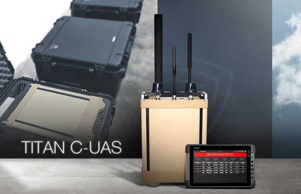
Titan C-UAS systems are deployed globally, protecting combat forces, civilians, and critical infrastructure. (Photo: Citadel Defense)
U.S. military, government and international customers opt for Citadel’s Titan for drone protection
Citadel Defense continues to experience rapid growth after being awarded several significant Defense and Homeland Security contracts for its C-UAS (counter unmanned aircraft systems) solutions.
Malicious drone activity, ranging from single-use hostile small unmanned aerial systems to drone swarms continue to threaten safety and national security. Over the past 18 months, Citadel has received orders for more than $17.5 million in products and services to support anti-drone initiatives around the world.
According to the company, the growth is a direct result of delivering reliable and effective force protection against individual drones and swarms for military, government and international customers over the past two years.
Citadel Defense’s automated counter drone solution uses artificial intelligence and machine learning as a reliable and scalable approach for addressing emerging threats.
To address the surge in global demand for Titan systems, Citadel has expanded its manufacturing capabilities in San Diego, California, to support production of up to 50 Titan systems a month. The company uses U.S. suppliers with more than 70% of components being sourced locally in Southern California to improve responsiveness when executing on urgent customer requests.
As new drones are released to the market, Titan systems receive new software to address the new threats. If Titan’s AI algorithms do not detect the threat right away, the company explained that it can deliver an end-to-end capability in 72 hours for most drones and less than 4 weeks for the most complex drone signals.
The use of AI, deepnets and adaptive countermeasures provide Titan with scalable force protection that can address the needs of the small unit, a large base or A mobile vehicle. The Titan system is being effectively integrated into layered solutions that combine radar, optics and kinetic countermeasures to help customers detect, identify, track, defeat and report on threat sUAS.
“Designing agility into our product development process from the beginning has allowed us to iterate in real-time alongside our customers and rapidly deploy new capabilities to improve mission outcomes,” said Christopher Williams, CEO of Citadel Defense.
As radiofrequency-based solutions become an important requirement for layered C-UAS solutions, Citadel has had its capabilities extensively evaluated by U.S. Army, Navy, Air Force, SOCOM, and DHS Test & Evaluation teams. Titan is being used to protect high-value assets in urban, rural and maritime environments.
“Designing our system to meet unpredictable mission scenarios was made possible by direct feedback from operators experiencing drone incursions on the front lines,” explained Williams. “The threat environment is always evolving which requires a product development approach that can adapt and respond. A combination of human-centered design and AI-powered technology have helped Citadel differentiate ourselves from traditional defense contractors.”
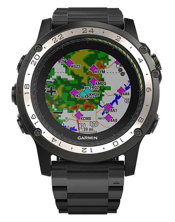
Weather radar overlay feature within Garmin D2 Charlie. (Photo: Garmin)
The U.S. Air Force is expected to take delivery of more than 100 D2 Charlie aviator watches for the specialized pilot group that flies the Lockheed U-2 aircraft.
Garmin’s D2 Charlie aviator watch has been selected by the United States Air Force (USAF) for use by the pilots of the Lockheed U-2 aircraft.
The high-sensitivity WAAS GPS-enabled D2 Charlie aviator watch incorporates global navigation capability, rich and colorful moving maps and more, providing pilots in the USAF with an exclusive, back-up navigation timepiece in the cockpit.
The watch receives both GPS and GLONASS signals.
U-2 for reconnaissance. The U-2 is a versatile, ultra-high-altitude reconnaissance aircraft used for intelligence gathering, research and communication purposes.
The U-2 provides high-altitude, all-weather surveillance and reconnaissance, day or night, in direct support of U.S. and allied forces. It delivers critical imagery and signals intelligence to decision makers throughout all phases of conflict, including peacetime indications and warnings, low-intensity conflict, and large-scale hostilities.
100 watches ordered. The USAF is expected to take delivery of more than 100 D2 Charlie aviator watches for the specialized pilot group that flies the Lockheed U-2 aircraft. With a service ceiling of 70,000 feet, the D2 Charlie will provide unique benefits such as barometric-based O2 alerting and GPS-specific features including track, distance to the next waypoint, estimated time enroute and more.
“Garmin is honored to have been selected by the United States Air Force to equip the men and women who fly one of the most iconic aircraft in the history of aviation,” said Carl Wolf, Garmin vice president of aviation sales and marketing. “The D2 Charlie aviator watch will be an integral and functional part of the U-2 pilot’s toolkit.”
A U.S. Air Force U-2 Dragon Lady flies a training mission. (Photo: U.S. Air Force photo by Master Sgt. Rose Reynolds):
Designed with pilots of varying backgrounds and missions, the D2 Charlie aviator watch features a colorful, dynamic moving map which depicts airports, navaids, roads, bodies of water, cities and more, offering greater situational awareness.
When the D2 Charlie is paired with Garmin Connect on a connected mobile device, pilots can view weather radar on top of the map display relative to flight plan information.
Pilots can also display estimated time enroute (ETE), universal coordinated time (UTC) or other pilot-selectable data fields overtop the map so it’s easy to monitor the progress of a flight and view pertinent flight information simultaneously.
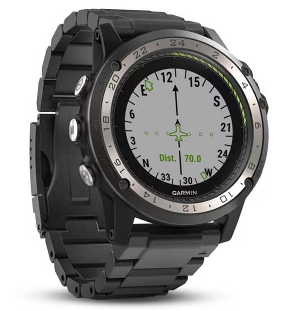
The Direct-to feature within D2 Charlie watch. (Photo: Garmin)
Standalone navigator. An advanced, standalone navigator, the D2 Charlie aviator watch incorporates exclusive navigation functions and capabilities, including dedicated direct-to and nearest buttons along the side of the bezel that allow the user to easily build or modify flight plans.
Airport information pages display communication frequencies, runway information (including dimensions and surface type), weather data and more for a specified airport.
The flight log page allows pilots to conveniently reference recent flights at their wrist, displaying date, flight duration, total distance and more of a particular flight. Additionally, improved flight planning capabilities include the option to add multiple waypoints within a single flight plan and the ability to navigate direct to any waypoint in a flight plan.
Heart-rate monitor. The D2 Charlie is made of premium materials, including a sapphire scratch-resistant crystal lens and a diamond-like carbon-coated titanium bezel for improved durability. A sunlight-readable, high-resolution color display with an LED backlight on the watch face allows pilots to view data in most lighting conditions in the cockpit.
The D2 Charlie offers up to 20 hours of battery life in GPS mode and up to 12 days in smartwatch mode.
Garmin Elevate wrist heart rate technology allows pilots to measure heart rate 24/7 alongside daily activity tracking. The D2 Charlie aviator watch also comes preloaded with a full multisport toolset for running, golfing, cycling, swimming, skiing and more. Water rated to 100 meters, it can also withstand swimming and other water activities. When paired with a compatible smartphone, customers can also view phone calls, text and email smart notifications at their wrist.
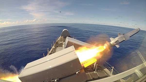
The Naval Strike Missile is a GPS-guided long-range, precision strike weapon that can find and destroy enemy ships at distances up to 100 nautical miles. The stealthy missile flies at sea-skimming altitude, has terrain-following capability (it banks to turn) and uses an imaging infrared seeker for precise targeting in challenging conditions. The missile employs a semi-armor-piercing warhead optimized for anti-surface warfare.
According to Raytheon, the missile also is suited for land attack missions because it can climb and descend with the terrain. It was successfully tested in a land-based mobile launcher configuration in 2018 as part of a multination military exercise. In 2019, the U.S. Marine Corps integrated a land-based Naval Strike Missile into its force structure, sharing costs and interoperability with the Navy.
The missile was first fired in the Indo-Pacific region, according to the Navy. Then, on Oct. 1, it was launched from the USS Gabrielle Giffords (LCS 10) during Pacific Griffin, an exercise conducted with the Singaporean navy near Guam Sep. 27 through Oct. 10, 2019.
The OTH-WS program is a long-range, surface-to-surface warfare system intended to offensively engage maritime targets both inside and beyond the radar horizon. The system consists of an operator interface console, Naval Strike Missile, and the Missile Launching System. The OTH-WS is intended to be a stand-alone system requiring minimal integration into the ship’s platform.
The Navy selected the Naval Strike Missile in 2018, with Raytheon as the contractor for its over-the-horizon defense of littoral combat ships and future frigates.
Also in 2019, the Navy conducted a structural test firing of the OTH-WS to assess the integrity and safety of the weapon system installation on the launch platform. The test showed there were no problems regarding integration of the missile launching system with the platform.
The Navy is planning to conduct Initial Operational Test and Evaluation and Live-Fire Test and Evaluation in fiscal years 2020-2022. and is developing a test and evaluation plan and live-fire test strategy.
The USS Gabrielle Giffords launches a Naval Strike Missile during exercise Pacific Griffin. (Photo: U.S. Navy//Chief Mass Communication Specialist Shannon Renfroe/Released.)
On April 2, a new museum exhibit will open that focuses on the U.S. Air Force’s role in the management of GPS satellite systems.
The National Museum of the United States Air Force is holding a grand opening event for the new GPS Exhibit from 2-3:30 p.m., with remarks by U.S. Air Force personnel involved with the exhibit followed by light refreshments.
The museum is located at 1100 Spaatz Street, Wright-Patterson Air Force Base, Riverside, Ohio.
On April 2, 2020 a new exhibit will open focusing on the U.S. Air Force role in the management of GPS satellite systems. (Artist’s concept: USAF)
History and Benefits. GPS began as a military navigation tool in the early 1960s. Later, the U.S. Air Force became the lead organization for developing the system. It manages the system, providing highly accurate position, navigation and timing information to users worldwide, for free.
The exhibit describes what GPS is and how it works by outlining satellite and ground systems and their historical development. It explains how atomic clocks and GPS satellites enable all kinds of important activities.
These include mapping and navigation for everyday users and the military, commerce, farming, construction, cell phone systems, the power grid, and climate research.
The exhibit also explains how satellite orbits work, and it outlines the problem of “space junk.”
Hands-on. Interactives and videos help all ages better understand GPS, learn how to find their location on the Earth, and see how orbits and satellites work.
The museum will be open late on opening day, allowing guests to tour the museum until 8 p.m., with an opportunity to walk inside an AC-130A. The Lockheed AC-130 gunship is a heavily armed, long-endurance, ground-attack variant of the C-130 Hercules transport, fixed-wing aircraft.
The exhibit opening will take place in the Space Gallery (fourth building).
Two new small unmanned aerial systems (sUAS) are available to the U.S. government defense and security markets.
Auterion Government Solutions Inc. and Quantum-Systems GmbH have partnered to bring the Vector and Scorpion to market. The partnership brings together high-quality sUAS hardware with a secure, scalable, open source, operating system, Auterion OS.
Auterion OS is employed on sUAS from small multi-rotors to hybrid VTOL Group 2 air vehicles. The open-source operating system aligns with the Defense Department’s Group 1 UAS Architecture.
2-in-1 UAS
Vector and Scorpion form a 2-in-1 system kit. Scorpion is a tri-copter that can be used for dynamic urban environments and other mission sets that require a combination of maneuverability and hover to collect intelligence, surveillance and reconnaissance (ISR) data, as well as situation awareness information. If required, it comes with a tethering system to enable 24/7 operations.
By configuring the base fuselage with fixed wings and tail section, Scorpion transforms into Vector, an energy-efficient, fixed-wing VTOL for longer range, longer endurance ISR missions.
The Vector. (Photo: Quantum-Systems)
Command and control
Quantum-Systems uses a proprietary flight control stack as well as its qBase command and control software on the two air vehicles.
When the platforms are integrated with Auterion Enterprise PX4 software, Auterion Ground Station software, and the Auterion Hand-Held Ground Control Station (H-GCS) they form an open ecosystem that is aligned and integrated with DoD’s Group 1 UAS Architecture and requirements for a common Group 1 control system.
The integration enables these sUAS to be extensible, tailorable and interoperable for customers in both the U.S. defense and security markets.
“We are excited to be working with Quantum-Systems to bring forth a new, integrated, rucksack portable sUAS that we feel will transform the way our customers collect, process and disseminate ISR and Situation Awareness information, in all environments,” said David Sharpin, CEO of AGS.
“By setting up a U.S. entity, Quantum-Systems will move closer to the customer while working on setting up a large-scale U.S. production,” said Florian Seibel, CEO of Quantum-Systems.
On Feb. 12, President Donald Trump signed an Executive Order establishing a comprehensive national policy to promote the responsible use of positioning, navigation and timing (PNT) services by the federal government.
The order directs federal agencies to take steps to reduce disruption of critical infrastructure that relies on PNT, including GPS. It also directs critical infrastructure owners and operators to strengthen their systems’ resilience.
Markets affected include including the electrical power grid, communications infrastructure and mobile devices, all modes of transportation, precision agriculture, weather forecasting and emergency response.
The federal government will engage both the public and private sectors to identify and promote responsible use of PNT services, with the goal of ensuring that “critical infrastructure can withstand disruption or manipulation of PNT services.”
“Because of the widespread adoption of PNT services, the disruption or manipulation of these services has the potential to adversely affect the national and economic security of the United States,” the order states. “To strengthen national resilience, the Federal Government must foster the responsible use of PNT services by critical infrastructure owners and operators,” the order reads.
PNT Profiles
The Commerce Department is tasked with developing PNT profiles, due a year from today, for PNT-dependent systems, networks and assets. The profiles will be developed through consultation with the private sector.
The profiles will also:
identify appropriate PNT services;
detect the disruption and manipulation of PNT services; and
manage the associated risks to the systems, networks and assets dependent on PNT services.
The profiles will be reviewed and updated every two years.
Reaction to the Order
Reacting to the Executive Order on PNT, J. David Grossman, executive director of the GPS Innovation Alliance (GPSIA), stated:
“The GPS Innovation Alliance (GPSIA) welcomes today’s Executive Order recognizing the critical economic and societal benefits of GPS and other Global Navigation Satellite Systems (GNSS). Resiliency is among the core attributes that have made GPS the gold standard for delivering positioning, navigation, and timing (PNT) functions to our military as well as a wide range of other sectors, including transportation, agriculture, electricity, and finance. Today’s Executive Order represents a crucial next step in ongoing efforts to maintain the security, robustness, and redundancy of PNT capabilities, including GPS, that millions of Americans rely on every day. GPSIA looks forward to working with key government stakeholders to support the implementation of this effort.”
The Department of Transportation stated,
“Our challenge is to enable increased resilience across our transportation systems and ensure the traveling public and freight transporters experience an increased level of safety and efficiency without the possibility of interference caused by loss or manipulation of PNT.
Department of Homeland Security Acting Secretary Chad F. Wolf said,
“From mobile phone applications to automobile navigation, our digital, interconnected society is dependent every day on PNT services.That is why it’s critically important that PNT services remain properly functioning as a major component of the nation’s critical infrastructure. By adopting responsible use of PNT services, the federal government and owners and operators of critical infrastructure can contribute meaningfully to national resilience and ensure the continuous, uninterrupted delivery of services to the nation.”