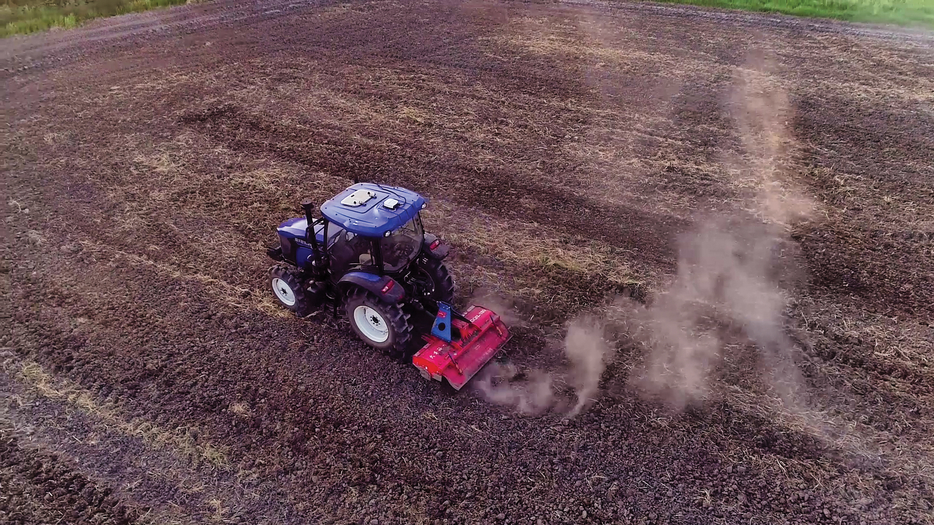
JCB has launched its Fastrac iCON tractor to the public featuring the Hexagon | NovAtel’s SMART7 GNSS receiver. The tractor also offers optional TerraStar Correction Services driving the iCONNECT precision technology package and offering operators an easy-to-use customizable experience.
The SMART7-I included in the new Fastrac iCON tractor is a rugged, waterproof, all-in-one GNSS smart antenna designed and tested specifically for the agriculture industry.
Connectivity is with Wi-Fi and Ethernet. TerraStar and RTK corrections provide the centimeter-level accuracy required for any farming application. With multi-constellation and multi-frequency capabilities, it is a dependable solution for farms with treelines and obstructions that may impede satellite signals.
With the availability of TerraStar Correction Services, operators can have the highest accuracy and year-over-year repeatability globally. TerraStar offers fast, consistent positioning through the planting, spraying and harvest cycle with 99.999% uptime and availability.
“The iCON tractor is designed around the farmer. We wanted a GNSS solution farmers can rely on that stands up to harsh agriculture environments while providing the accuracy to support our precision technology,” said Greg Fitton, general manager, Fastrac Sales at JCB. “We chose NovAtel as our GNSS experts because of their demonstrated reputation for quality, cutting-edge technology and performance, and their willingness to adapt to our needs.”
Interview with Sara Masterson, Director, Positioning Services, Hexagon’s Autonomy & Positioning division, Hexagon | NovAtel
The accuracy of GNSS receivers continues to increase thanks to new satellites and signals, improved antennas, etc. How is that changing the role of correction services?
For sure, the accuracy of GNSS receivers and antennas is improving. However, most applications still require a higher level of accuracy than what is available from an uncorrected position even with the positioning improvements brought by new constellations and signals. GNSS corrections are still required to enable, say, lane-level accuracy, or sidewalk-block accuracy for autonomous driving or mobile phone applications and for off-road autonomy applications such as construction, mining, agriculture — these all still require centimeter-level accuracy that is enabled through GNSS correction services.
Corrections also help by improving the availability and reliability of a solution. In the future, corrections will play a key role in adding integrity to enable functionally safe solutions that are required for new applications, such as autonomous driving.
There are many options for corrections — local, regional and global, ground-based and satellite-based, public and private, etc. Which of them are generally best for which applications and conditions?
That depends very much on the user and the application. There are many new correction services in the market. Some are free, some are commercial services. Even now we see in agriculture that WAAS is sufficient for some broadacre-type applications. So, we will continue to see a range of applications, some of which will be satisfied with the level of performance from a free service and others that will be looking for the better performance and service level guarantees that come with commercial services.
If something is not working when you are using a free service, there’s no one to call. With commercial services, you get responsive customer support and you pay for higher levels of performance and service availability. In many applications, especially those that involve autonomy or safety applications, you cannot afford to have downtime, or your machine just stops working, which costs money. So, many applications are still going to be needing the performance and service level guarantee that commercial services offer.
How does TerraStar fit into this range of options? What industries and applications are you targeting?
TerraStar has a range of services that enable us to target many industries and applications. Agriculture, of course, is one of the key applications for our services and we have customers using TerraStar for mobile mapping, UAVs and new autonomy-based applications. We are also involved with some interesting Hexagon joint projects that use TerraStar corrections for mine train automation and surveying and construction.
Our entry-level TerraStar-L service is still better in performance to many of the free services or to an SBAS-type service in terms of accuracy, but it is available globally, including regions where you don’t have other options. It also provides better pass-to-pass and year-over-year repeatability, as well as very quick reconvergence time if there are any issues with GNSS outages.
Our flagship offering is the TerraStar-C PRO service. That’s where we just introduced the “RTK from The Sky” technology, bringing the performance down to converging to two and a half centimeters in three minutes. That, too, is available globally which makes it a real game changer for customers in many different applications, because they can start to look at that service as an alternative to RTK and without the added connectivity logistics that an RTK solution brings.
Our RTK assist solutions are good augmentation solutions for customers who still primarily need RTK but experience some RTK correction outages – RTK ASSIST bridges through those outages. So, we have a wide range of service offerings in the portfolio that can address the positioning needs of many applications.
Photo: Hexagon | NovAtel
Will the reasons for having a base and rover setup decrease sharply?
Use of base and rover setups is already decreasing and being replaced by both PPP and network RTK solutions. There are applications where RTK still makes sense, such as those that have very tight vertical requirements and many survey applications. Another Hexagon division, Hexagon’s Geosystems division, incorporates TerraStar correction data into their new SmartNet Global offering as a seamless service that provides both SmartNet RTK plus TerraStar for either bridging outages or independent PPP operation, depending on the project’s location and whether they’re within range of SmartNet coverage.
There will be many applications that continue to benefit from a combination of the two technologies. However, as the PPP services, like TerraStar, continue to improve by reducing convergence time and providing highly reliable solutions, users in those applications can be confident that the standalone PPP solutions meet their performance needs and bring many additional benefits such as consistent, global coverage and performance.
Is TerraStar completely receiver agnostic?
TerraStar is currently only compatible with NovAtel’s GNSS hardware. Going forward, through the work that I referenced with autonomous driving and mass-market applications, we will be providing TerraStar services in industry-standard formats, depending on the inter-operability requirements coming from those applications. We expect that there will be demand for dual sourcing of corrections and interoperability between chipsets that are used in vehicles, for example. For those applications, we will be developing TerraStar services that are compatible with hardware from other GNSS manufacturers.
ComNav Technology now provides a GNSS high-precision positioning solution for navigation and positioning of autonomous lawn mowers. Environmentally friendly and intelligent robotic lawn mowers are growing more popular, making the mowing task easier, safer and more convenient.
R&D background
It is difficult to develop autonomous lawn mowers because they obtain navigation information by means of visual and acoustic sensors, usually through embedded cables in the working area and detection through eddy current sensors. The shortcomings are obvious: before the mower starts, it must be set up with cables and other equipment. Cable requirements differ in various countries, and cable laying can be complicated, wasting resources and money.
With these difficulties in mind, ComNav applied its K8 series of GNSS high-precision modules to lawn mowers to break through the application limit. It solved this accuracy problem to make the lawn mower achieve centimeter-level driving according to the setup path in an open field. With ComNav’s other technologies — quantum algorithm and LAI, HighLock, PPP, RTK-KEEP — the law mowers continues to operate under trees, around corners or in other obscured areas.
Introduction of ComNav’s solution
With the K8 series module, ComNav facilitates the lawn mower’s fieldwork with position data provided by GPS, GLONASS, Galileo, Beidou, QZSS, IRNSS and SBAS.
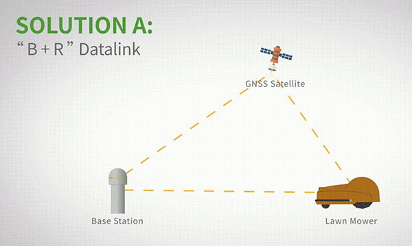
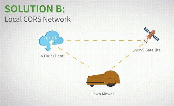
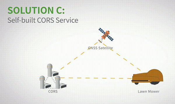
The high-precision positioning system for lawn mowers consists of a base station and a rover station. Three solutions are recommended for the terminal to obtain differential data from the base station.
Base and rover datalink. A base station acquires differential data through a datalink and provides corrections to the rover. The rover station — comprising the parts installed on the lawn mower, including the GNSS antenna, the GNSS high-precision module, datalink and UHF antenna — enables centimeter-level positioning and navigation.
Image: ComNav
Local CORS network. Utilizing existed local CORS, the rover station obtains differential data from the CORS service, enabling the lawn mower to achieve positioning and navigation accuracy on a centimeter level.
Image: ComNav
Self-built CORS network. Base stations can be placed anywhere based on requirements. Doing so eliminates the worry about prevailing conditions and makes high-precision positioning and navigation of lawn mowers possible.
Image: ComNav
Technology Features
LAI technology. ComNav’s patented low-power anti-interference (LAI) technology provides a jamming-to-signal ratio of up to 50 dB. Power consumption is only 0.1 W when turned on. By quickly detecting and eliminating interference with simple settings, LAI technology can reduce failure time and ensure safe operation. The technology can generate a spectrum diagram of interference sources, enabling identification of interference types and potential interference sources.
Quantum algorithm. ComNav’s quantum algorithm has sophisticated technology for detecting and repairing cycle slips. It uses full-constellation and full-frequency tracking capabilities along with multi-frequency combination, model and parameter estimation. Quantum is able to eliminate errors caused by the ionosphere, the troposphere and multipath in seconds. As a result, the initialization time of real-time kinematic (RTK) is greatly shortened and precision and reliability are improved. Meanwhile, the extra-long baseline calculation capability expands the operation range.
RTK-KEEP technology. By estimating model and parameter values, RTK-KEEP Technology can reduce errors caused by satellite orbit, clock difference, ionosphere and troposphere when the base station’s data is lost. Centimeter-level accuracy can be kept for more than 10 minutes, greatly improving the availability of RTK.
Benefits of ComNav’s Solution
ComNav’s solution allows the lawn mower to achieve centimeter-level positioning and reduce mowing repetitions. It helps the lawnmower to operate safely and reliably in the corners, under trees, or in other places where satellite signals are weak or lost. With its strong anti-interference capabilities, the lawn mower can maintain continuous and effective positioning in complex environments, meeting the needs of a variety of applications.
PRECISION AGRICULTURE reduces inputs of seed, water, fertilizer, pesticides and fuel. (Photo: CHCNAV)
Precision agriculture refers to the ability of farmers to observe, measure and respond more precisely to the variability of soil and crop characteristics within and between fields by using maps of these characteristics and GNSS navigation. It enables them to reduce inputs of seed, water, fertilizer, pesticides and fuel while increasing outputs. Adoption of precision agriculture technology and practices has increased steadily over the past three decades and now covers the majority of U.S. farmland.
We asked three companies that manufacture GNSS receivers optimized for precision agriculture about their challenges and plans.
What are the key challenges for precise positioning in agriculture?
One of the main concerns is the impact of obstructions — both natural, such as tree canopy and topographies, and manmade, such as buildings, silos, etc. The mounting location of the GNSS antenna on an agricultural vehicle or implement can emphasize multipath effects and limit GNSS signal availability.
Our solution for these challenges is the use of a multi-frequency receiver. In this case, the increased number of tracked GNSS signals (from GPS, Galileo, GLONASS and BeiDou), as provided by the latest Hemisphere GNSS technology used with the A631 Smart Antenna product, allows the receiver to overcome challenging conditions to ensure a stable and robust positioning solution. For example, if a tree line blocks a part of the sky at the headland of the field, it can be compensated for with additional satellite signals available outside of the blocked area, so that guidance, automated steering and application control are not interrupted. Dust and vibrations are not an issue for us due to the rugged design of the A631 GNSS Smart Antenna. However, depending upon the radio link used, long-distance RF communications for real-time kinematic (RTK) corrections can become a limiting factor. In this case, we often propose using RTK corrections over NTRIP or considering our Atlas L-band correction service for the as an RTK-like alternative.
What is the requirement for start-up time?
Although farmers spend hours in the field during the season, the planting and harvesting windows are limited; therefore, time is critical. The requirement from farmers is to be ready to go when they start their machine. During busy times in the season, farmers often leave their equipment in the field, so startup times may only be a few minutes. We meet this requirement with our startup times for SBAS and RTK corrections and the Atlas AutoSeed feature for L-band corrections. Atlas AutoSeed allows users to suspend Atlas use for any period of time, and upon returning to their last location, the Atlas system uses AutoSeed to rapidly reconverge to a high-accuracy converged position.
What is the accuracy requirement for planting?
Especially row crop planting over what we refer to as broad acre farming requires accuracy to within a few inches, which we offer with our Atlas H10 correction service. Depending upon the farming practices used (such as controlled traffic or inter-row applications), these demands are not only for accuracy, but also for repeatability of the positioning solution.
Another area that demands high accuracy is the production of specialty crops. Per our experience, this farming practice requires sub-inch accuracy and repeatability, which we meet with our RTK solutions.
What is the difference between Atlas and Atlas Basic?
We think of Atlas Basic as a global solution comparable to the different regional offerings for SBAS corrections in terms of accuracy. This means a radius 95% pass-to-pass (R95 P2P) accuracy of around 30 cm with absolute accuracy in the submeter area. We feel that this meets the “basic” needs for all precision agriculture applications.
If a customer is looking for higher accuracies, we offer the H30 and H10 Atlas Correction Services. For comparison, Atlas H30 provides R95 P2P accuracy of 15 cm, and H10 provides R95 P2P accuracy of 4 cm.
Besides your GNSS receivers and corrections services, what hardware, software and services do you provide for precision agriculture?
We announced our new MaveriX precision agriculture solution in September 2021. It uses our recognized A631 Smart Antenna and provides a complete precision agriculture solution combined with the M7 and M10 terminals, eDriveM1 steering controller, ESi2 electric steering wheel and AC110 application controller. The MaveriX precision agriculture application software, which runs on our MaveriX terminals, is the centerpiece of the system. The first production systems are being used by customers in North America this spring.
Ling Hu, Precision Agriculture Business Development Manager
What are the key challenges for precise positioning in agriculture?
Normally in the agricultural field, the environment is harsh (mud, slopes, shocks), which requires the system to be rated IP65 and above and vibration resistant. In some areas, the signal coverage of cellular phones may be insufficient. When that is the case, a UHF modem-type communication is more commonly used with a distance constraint related to the propagation of UHF signals, strongly related to the quality of the installation of the GNSS base station (height of the UHF antenna, gain, immediate environment of the station). Our NX510 SE overcomes that issue by integrating two communication modes, 4G and UHF.
CHCNAV’S GNSS RECEIVERS can be easily switched between tractors. (Photo: CHCNav)
Is planting the application that requires the highest accuracy? What accuracy can you consistently provide?
Certainly, planting requires the highest accuracy of 2.5 cm from pass to pass. With a stable GNSS RTK correction, centimeter accuracy can be provided reliably.
What is the requirement for startup time? What do you deliver?
The startup and initialization of the system should take as little time as possible and is usually done within 1 to 2 minutes from cold start. Farmers usually start their system when they drive the tractor out of the shed and are therefore ready to work as soon as they arrive in their field. Warm start (reacquisition + RTK fixed) is more important in case of obstacles or loss of the RTK correction used by the customer, when using the auto-steering/guidance system in the field. It is typically about 10 seconds.
Besides your GNSS receivers, do you provide any additional hardware, software or services (such as support and training) for precision agriculture?
Our NX510 autopilot kit consists of a receiver, display, motor, angle sensor, camera and accessories, so users can start working immediately without purchasing additional options.
In addition to automated steering systems, CHCNAV also provides complementary solutions that allow farms to be autonomous in terms of GNSS RTK corrections. These solutions consist of GNSS base stations with an integrated or external radio modem and GNSS NTRIP stations for connection over 4G. Individual GNSS stations can be networked using our CPS Net software, which can be operated by a group of farmers, agricultural cooperatives or tractor dealers. Training and user support is provided by our network of authorized agricultural resellers to ensure the closest possible service to our users.
Wang Xiaohui, Technical Director, Antenna Department
What are the key challenges for precise positioning in agriculture?
Obtaining accurate position information in real time requires real-time kinematic (RTK) positioning. There are many ways to obtain differential data. One is to establish a reference station and broadcast differential data through short-distance communication methods. This method’s disadvantage is the high cost of stations and the limited transmission distance. Another is to broadcast RTK data through an LTE network. This is convenient, but if the LTE signal coverage is poor, RTK positioning may not be achieved. A third method is to rely on satellite-based augmentation. This is independent of ground communication equipment, but has a relatively long convergence time and may be greatly affected by signal occultation.
Agricultural machinery must work in harsh environments, such as extreme heat, severe cold and strong vibrations. Consequently, the antenna must be enclosed in a robust housing with excellent protection to guarantee long-time outdoor work.
When agricultural machinery operates near densely packed and tall trees, positioning accuracy will be significantly affected. Limits on the size and cost of antennas for agricultural machinery prevent the use of choke-ring structures. Therefore, the key to achieving high-precision positioning lies in how to receive more satellite signals and avoid multipath interference in a small antenna size.
How can the antenna help with these challenges?
Harxon’s X-Survey antenna is highly integrated and multi-functional. It embeds antennas for GNSS (GPS, GLONASS, BeiDou, Galileo, QZSS, NavIc, other regional systems and SBAS), 4G, Bluetooth/Wi-Fi 900M/2.4G radio, and other frequencies. The X-Survey enables users to choose the most appropriate way for them to acquire differential data — LTE, Wi-Fi, radio or SBAS — making high-precision positioning possible in most environments.
Harxon has designed many high-precision antennas with different structures for various application environments, including those that are waterproof and dustproof and those that can withstand very high and low temperatures and violent vibrations.
Additionally, Harxon’s antennas adopt unique cross-polarization suppression technology, with good circular polarization characteristics, providing effective suppression performance for multipath signals.
How does Harxon support TerraStar correction services?
Harxon’s TS112 PRO Smart Antenna provides reliable positioning solutions for agricultural automatic guidance. It can obtain RTK-level positioning information by receiving correction data from the embedded UHF radio or its GSM modem. Also, TS112 PRO embeds a Hexagon | NovAtel OEM GNSS module, and TerraStar multi-constellation corrections are available globally on this compatible module. TerraStar corrections are available as a termed subscription from Hexagon | NovAtel.
New GradeMetrix features include knuckle boom and swing boom support
Hemisphere GNSS has expanded the features of its GradeMetrix excavator solutions, adding support for knuckle boom and swing boom excavators as part of its GradeMetrix 3D Excavator solution.
The additional feature sets unlock enormous potential for GradeMetrix excavators, especially in the compact excavator market, according to Hemisphere. “Hemisphere recognizes that machine control technology for compact excavators has been an underserved audience globally,” said Miles Ware, vice president of marketing. “Based on direct feedback from our global machine control partners, and endless hours of testing, we are excited to introduce these options that will further enhance the available ROI [return on investment] for our customers.”
Photo: Hemisphere GNSS
“Hemisphere’s commitment to globally expand the access to machine-control technology continues to be a key component of our growth strategy,” said Farlin Halsey, president and CEO of Hemisphere GNSS. “Our strategy to combine best-in-class GNSS technology, with modern, efficient and intuitive features, further advances our efforts to make machine-control technology available to the global construction community, including such key customers as Iwasaki.”
“The opportunity to introduce a solution that supports excavators equipped with knuckle boom is a very important achievement for our organization,” said Satoshi Furuguchi, CEO of Iwasaki Co. Ltd. “Iwasaki and Hemisphere have a great partnership, and we look forward to empowering additional productivity solutions together.”
Hemisphere will make knuckle boom and swing boom options available in several of its new GradeMetrix excavator kits. Existing GradeMetrix excavator customers will have an option to add this feature to their current systems via an additional cable and sensor package available from an authorized GradeMetrix dealer.
Hemisphere GNSS is exhibiting at the Construction & Survey Productivity Improvement Expo in Chiba, Japan, at booth E-11.
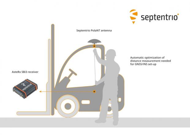
Septentrio has taken a step toward simplifying the integration process of its GNSS receivers that include inertial navigation systems (GNSS/INS). Its new RxLeverArm software tool aids GNSS/INS installation and improves accuracy, with automatic optimization of lever-arm settings.
RxLeverArm is now part of Septentrio’s RxTools software package included with every Septentrio GNSS/INS receiver. This new tool visualizes, validates and automatically calibrates the exact distance between the INS sensor and the antenna, removing the need for accurate distance measurements with complex instruments.
GNSS/INS receiver setup is significantly simplified with RxLeverArm functionality, which enables users to start testing minutes after receiver installation. (Image: Septentrio)
“We are focusing our design around easy, efficient and effective INS installations ensuring short time-to-market and accurate deployment for our customers,” said Danilo Sabbatini, product manager at Septentrio.
“The RxLeverArm tool in combination with the intuitive web user interface, as well as the support material available in our knowledge base, enables customers to start testing within minutes after the physical installation of their receiver,” Sabbatini said.
For lever-arm compensation, users now only need to measure the rough distance between the inertial measurement unit (IMU) and the main GNSS antenna reference points on the vehicle. Data is then logged under open-sky conditions, which allows the RxLeverArm tool to optimize the initial rough distance measurement and prevent common errors such as sign inversion.
The result is simplification of the installation process and better accuracy of the lever-arm measurement.
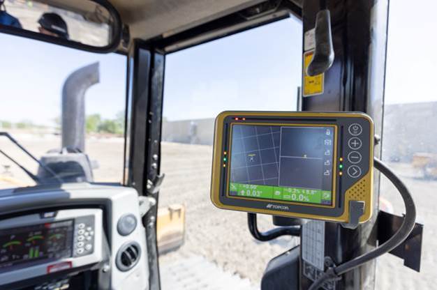
Topcon Positioning Group has announced a new option for Caterpillar Next Gen excavator users to leverage Topcon 3D machine control functionality together with Cat Assist features. As a result of new compatibility of the Topcon 3D Excavator System with Caterpillar factory-installed NGH sensors, customers will experience simplified installation of the Topcon aftermarket system into Caterpillar’s existing 2D excavator systems, in coordination with Topcon and Caterpillar dealers.
“With increased pressure for productivity and accuracy, and the industry’s need for skilled operators, the solution is timely,” said Jamie Williamson, Topcon executive vice president. “The customer will have the benefit of Topcon 3D Excavator System and Caterpillar Assist features working together. Once the user is acquainted with the combined system, it will be easy to be a more productive operator.”
The Topcon system is designed to provide real-time, dynamic, on-screen bucket location and design views, resulting in the operator cutting grade faster and more accurately. The operator can create, cut and check designs directly from the cab. Together with Caterpillar boom and bucket automation, operators can deliver quality work all day long with less fatigue, according to Topcon.
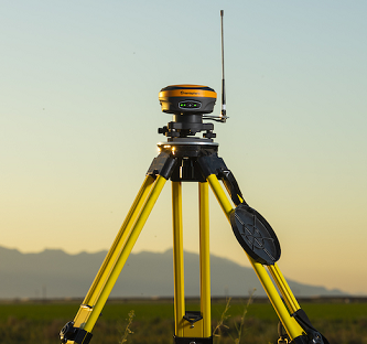
The S631 smart antenna on a tripod. (Photo: Hemisphere GNSS)
Hemisphere GNSS distribution agreement with Volvo Construction Equipment to provide new S631 GNSS survey smart antenna
Volvo Construction Equipment North America will add the Hemisphere GNSS S631 Survey Smart Antenna to its marketplace portfolio for Volvo CE dealers and end users. The new S631 adds robust performance and high precision in a compact and rugged package.
The distribution agreement with Volvo CE expands Hemisphere GNSS’s list of partners offering Hemisphere’s latest technology for machine control products and solutions.
The addition of the Hemisphere GNSS S631 Survey Smart Antenna aligns with Volvo CE’s focus on the latest technology and solutions for machine control applications, the company said.
“Partnership between Hemisphere and Volvo Group companies goes back 15 years when we began to provide Volvo Penta our heading units for marine applications,” said Randy Noland, VP Global Sales and Business Development at Hemisphere. “That business provided a technological foundation between our two organizations that eventually brought us together again with Volvo CE as a provider of high-precision, rugged GNSS receivers for machine control for use in Volvo Co-Pilot products. We are pleased the partnership continues to grow, with additional GNSS receivers now available as an extended offering through Volvo CE North American dealers. We greatly value our relationship.”
About the S361 Smart Antenna
The S631 provides robust performance and high precision in a compact and rugged package. With multiple wireless communication ports and an open GNSS interface, the S631 can be used in a variety of operating modes, as a rover or base station.
The built-in web user interface (WebUI) can be used to control and manage the receiver status and operation, as well as to upgrade the S631 with new firmware and activations.
Corrections. S631 is Athena-enabled and Atlas-capable (subscription required). With Athena, S631 provides precision RTK performance when receiving corrections from a static base station or network RTK correction system. With multiple connectivity options, the S631 allows for RTK corrections to be received over radio, cell modem, Wi-Fi, Bluetooth or serial connection.
The S631 receiver also enables users to work with Atlas, Hemisphere’s global correction service. Atlas delivers worldwide centimeter-level correction data over L-band communication satellites.
Key Features
Multi-frequency GPS, GLONASS, BeiDou, Galileo, QZSS, IRNSS and Atlas L-band
Long-range RTK baselines up to 50 km with fast acquisition times
UHF (400 MHz and 900 MHz), cellular, Bluetooth and Wi-Fi wireless communication
Athena GNSS engine for precision RTK performance
Internal sensor corrects collected point coordinates to within 2 cm
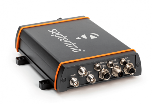
Septentrio has launched the AsteRx-U3 ruggedized GNSS receiver, successor to the AsteRx-U for construction, mining and other machine control applications.
The new receiver combines Septentrio’s latest triple-band precise positioning GNSS core with extended wireless communication features including Wi-Fi, UHF and 4G LTE. The versatile connectivity features of this receiver make it easy to fit it into any control system and enable simple and cost-effective overall design.
“We are excited to introduce AsteRx-U3 to the market of industrial automation,” said Silviu Taujan, product manager at Septentrio. “Its advanced connectivity package offers manufacturers and integrators access to reliable high-accuracy positioning in a system which is versatile, easy to use and easy to integrate.”
The AsteRx-U3 offers a unique feature, a guaranteed low latency of under 10 msec with a high data rate, which allows machines to work with rapid as well as accurate movements. An IP68-rated housing with fixing brackets and robust M12 connectors ensures a quick and reliable installation.
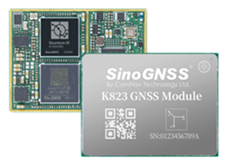
ComNav Technology has released the P300 Series GNSS tablet to the global market. Based on the company’s K8 GNSS OEM platform, the high-precision in-cab Android rugged tablet brings innovative performance and ease of use to various operations in precision agriculture, autonomous driving, machine control and other industries, the company said.
Embedded with the new-generation K8 OEM module, the P300 series GNSS tablet can track all current and planned constellations (including GPS, BeiDou, BeiDou-3, GLONASS, Galileo, QZSS) and reach centimeter-level accuracy. Using the advanced Quantum III technology in combination with upgraded SinoGNSS ASIC chip and advanced microprocessor unit, the P300 series is capable of providing enhanced heading and positioning performance for everyday field use.
Photo: ComNav
Features of the P300 include dual-card, dual-standby, various interfaces, multiple wireless connections and data transmission modules for CAN, PPS and Event. The P300 can adapt to a variety of application scenarios to meet different needs of users. The aluminum-magnesium alloy body makes the P300 robust, able to cope with the rigors and demands of tough construction jobs and strenuous vibrations.
The P300 series runs the Android operating system and is compatible with most Android apps. Compared to traditional GNSS receivers the high-definition color touchscreen and intuitive interface make it easy for both beginner and advanced users to operate.
The P300 series tablet includes P300 Plus (10.1-inch) and P300 Mini (8-inch). Both deliver the same high performance, user-friendly design, powerful connectivity and rugged construction to users. Both sizes are available now.
Topcon Positioning Group has announced its MC-Max machine control solution. Based on its MC-X machine control platform, and backed by Sitelink3D — the company’s real-time, cloud-based data management ecosystem — MC-Max is a scalable solution for mixed-fleet heavy equipment environments. It is designed to adapt to owners’ machine control and data integration needs as their fleets and workflows expand.
MC-Max increases processing power, speed, accuracy, versatility and reliability; and can be installed on a full range of dozers and excavators, using the same basic modular components. Modern, redesigned user and product interfaces were developed based on real-world applications and customer feedback and provide a simplified and immersive user experience that allows operators to learn the system easily.
“With MC-Max, we’ve created a solution that is flexible and can continue to grow as a contractor’s needs and capabilities expand,” said Jamie Williamson, executive vice president, Topcon Positioning Group. “This new solution provides improved scalability and precision in the field and offers business owners real-time data integration, connectivity and resource management capabilities across their entire workflow.”
The MC-Max solution offers flexible mounting solutions, as well as optional automatic blade and bucket control for a variety of machines. The system also provides a full battery of positioning technologies ranging from slope control to laser, multi-constellation GNSS, robotic total station and millimeter GPS systems.
MC-Max provides project managers a real-time view of machine positions, activities and onsite progress, and is compatible with a wide range of site communications systems.
Topcon MC-X Platform
The Topcon MC-X Platform is designed to make machine control easy to use and affordable for all contractors. The platform ties together mixed fleets by interacting with multiple versions of 3D-MC, providing connectivity to Sitelink3D and taking advantage of the multi-constellation capabilities of GNSS antennas.
Flanders uses Septentrio receivers to guide automated blasthole drills, such as at this South African mine run by AngloGold Ashanti. Photo: Anglogold Ashanti/Flanders
Flanders, a U.S.-based company with expertise in electrical machinery and control systems, has developed its proprietary ARDVARC advanced drill-rig control system to control mine-drilling machines, making them safer and more efficient. The drill rigs equipped with ARDVARC create holes with centimeter precision. This ensures optimal rock fragmentation, simplifying and expediting subsequent jobs such as stone extraction and removal.
Mines close to the poles or to the magnetic equator, such as those in the Amazon, are challenging for GNSS receivers because they tend to experience the most intense ionospheric scintillations, resulting from rapid fluctuations in the electron density in the ionosphere. These scintillations affect GNSS signals that travel from space to Earth, causing degradation of positioning accuracy or even positioning loss.
To address this challenge, ARDVARC uses Septentrio AsteRx-U GNSS receivers. They are housed in a tough IP67 enclosure and run Septentrio’s proprietary GNSS+ algorithms including IONO+, which ensures high-accuracy positioning even during ionospheric scintillations.
ARDVARC’s benefits include a faster drill cycle time, increased drill hole location precision, increased drill-rig component operating life, improved fragmentation and greater operator safety. The system is available in several levels.
The Intelli-rig manual control system also delivers data on the position of each blast hole, the machine operation and the drilling conditions; it incorporates mine-planning functionality using the mine’s existing or Flanders’ optional GPS equipment.
One-touch converts a manually operated machine to one operated with a single touch, increasing productivity. Once the machine operator positions the drill rig over the desired target, One-touch initiates the automated drilling process, which includes machine leveling, hole collaring, drilling to elevation and angle, rod handling, bit retraction and jack reset.
The fully autonomous drilling solution removes the operator from the cab, allowing one operator to monitor multiple drilling operations from a safe distance. The solution increases productivity by enabling drilling during blasting and shift changes. It uses Flanders’ HazCam to monitor the surroundings, preventing the drill from operating in unsafe conditions.