Category: Machine Control / Agriculture

  • Swift Navigation, SolarCleano: cleaning robots keep solar power running

    Swift Navigation, SolarCleano: cleaning robots keep solar power running

    A SolarCleano F1A robot tackles a tough cleaning challenge on a solar farm in Saudi Arabia. Photo:: SolarCleano
    A SolarCleano F1A robot tackles a tough cleaning challenge on a solar farm in Saudi Arabia. (Photo: SolarCleano)

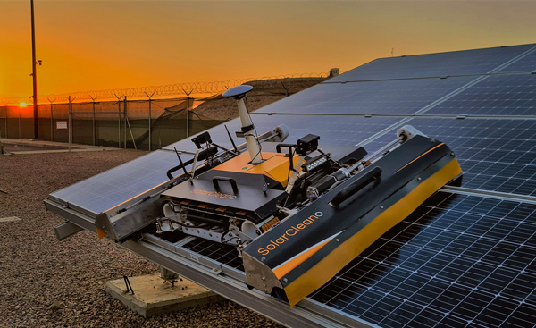
    SolarCleano, based in Garnich, Luxembourg, makes robots that clean large solar panel installations using GNSS receivers and corrections from Swift Navigation. We asked Christophe Timmermans, SolarCleano’s managing director, a few questions about its technology.

    How often do solar panels need to be cleaned?

    For decades, it was believed that solar panels did not need to be cleaned due to their angle to the ground and rain. Nowadays, however, the cleaning of solar panels is widely accepted as necessary to optimize a plant’s return on investment (ROI).

    How much time per sq. meter do your machines take to clean solar panels?

    To provide the fastest possible ROI to our customers, we developed a range of robots to best address the needs of various solar plant layouts. A large utility-scale project with high level of soiling losses in a desert environment will need a very fast and reactive cleaning solution such as our SolarBridge B1, which can clean 24/7/365 fully autonomously. The most suitable solution for a farm rooftop in Germany that needs to be cleaned three to four times a year might be our F1 model, which can clean the equivalent of up to two soccer fields a day. It is designed for rooftops, floating panels and mid-size plants up to 50 MW. While the speed of cleaning is a very important variable, the quality of cleaning is often considered as the driver to performance, which is why we propose different types of brushes depending on the soiling types. Plus, the robot speed can be modified according to the soiling level.

    Why do robots need GNSS receivers to clean solar panels?

    Moving on inclined, wet glass surfaces makes odometry unreliable because robots might occasionally slip. Therefore, GNSS is the most reliable way to continuously monitor their exact position. Our robots also need path planning because they cannot operate randomly like lawn mowers. Safety is obviously a major concern; we need a very high localization accuracy to ensure that robots don’t fall off the panels. Finally, the largest solar plants are developed in dry, remote locations with high irradiation such as the Sahara, Atacama and Australian deserts. GNSS allows us to have very accurate localization even in those remote areas. In addition, this solution can easily be installed on already-existing solar plants with little capital expenditure.

    What spatial accuracy requirements do the robots have for this task?

    Safety is our absolute priority. Therefore, our robots need an accuracy of less than 3 cm. They also need to be aware, in real time, of changes in their surroundings, such as maintenance teams, animals and uneven ground.

    On large solar farms, GNSS receivers always have a clear line of sight to the satellites and do not suffer from multipath. So, what are the key technical challenges?

    Our robots have the additional advantage that they do not need to drive very fast. However, we need to manage fleets of robots on the other side of the world in regions difficult to access and with harsh weather conditions, such as very high or low temperatures and the accumulation of dust behind panels due to air vortices. We need to be able to perform remote maintenance and solve any issue from our control center in Luxembourg. These challenges make our robots increasingly robust. With a current fleet of more than 300 robots around the world, we collect lessons every day to ensure a greater reliability for our upcoming generations of robots.

    Why did you choose to partner with Swift Navigation?

    We share a vision with Swift: “Accessible automated solutions serving sustainable goals.” We also share other important values, such as “iterate quickly” and “focus on what matters.”

  • ComNav Technology: Proving high-tech is not a last resort

    ComNav Technology: Proving high-tech is not a last resort

    ComNav’s high-accuracy PileMaster sped construction of the Aarah Resort in the Maldives. Photo: LANKA Foundation and Piling Services Pvt. Ltd.
    ComNav’s high-accuracy PileMaster sped construction of the Aarah Resort in the Maldives. Photo: LANKA Foundation and Piling Services Pvt. Ltd.

    The construction of the Aarah Resort in the Maldives involved building 64 luxury water villas and 12 beach buildings on a shallow-water area with about 1,400 piles. LANKA Foundation and Piling Services Pvt. Ltd. was able to complete the piling project in only 32 days by using a high-accuracy piling solution from ComNav Technology Ltd.

    The traditional piling approach requires many surveyors to stake out the positions of the piles underwater in advance. Not only is this process labor-intensive, it also creates a real-time problem: even if the coordinates are measured accurately by lofting, the primary coordinate markers are soon out of position due to the movement of the piling machines. The stakeout’s accuracy is also threatened by strong waves, ocean currents and coral reefs. Furthermore, in the subsequent piling process, the piling accuracy is reduced due to artificial aiming. During the whole process, surveyors must work in the water and fix the piles at short range, which is dangerous. For these reasons, the traditional piling approach is a low-efficiency, high-cost and high-risk operation.

    Photo: Google Earth
    Photo: Google Earth

    ComNav’s professional positioning solution for high-accuracy piling provides a 9-inch high-resolution tablet with an integrated GNSS receiver, a T300 GNSS receiver as the base station, and two AT340 antennas with magnetic mounts combined with PileMaster software. Its integrated GNSS receiver tracks GPS, GLONASS and BeiDou signals, enabling the system to work even in challenging environments. The system can acquire real-time kinematic (RTK) corrections via an internal UHF transceiver from the T300 receiver or connect to a local continuously operating reference station (CORS). Moreover, PileMaster is designed with an intuitive interface with clear element-management capability, supporting import of up to 10,000 points from Excel, TXT and CAD formats to meet the specific demands of a high-accuracy piling project.

    Compared to the traditional piling method, ComNav’s intelligent control system for piling is an all-weather, high-accuracy solution with the additional advantages of being widely compatible and easy to manage. Through software system control and real-time processing and display, it can greatly reduce the number of surveyors required on-site. The system can guide users to the location, shorten the construction period, save construction costs, and enable intelligent visualization and monitoring to ensure high-precision construction work.

    After a first successful application in 2017, Foresight Surveyors Pvt. Ltd, ComNav’s local partner in the Maldives, used the solution in many projects, including construction of the Kunaavashi Resort & Spa in 2018 and the Kuda Villingili, Dhigufaru Island and Maniya Faru resorts in 2019.

  • Hexagon: Mining safely with rock-solid technology

    Hexagon: Mining safely with rock-solid technology

    Photo:BeyondImages/iStock/Getty Images Plus/Getty Images
    A mining road-train loaded with ore passes through an outback town. A Hexagon system will guide autonomous movement of similar heavy vehicles. Photo: BeyondImages/iStock/Getty Images Plus/Getty Images

    Hexagon’s Autonomy & Positioning and Mining divisions recently partnered with Mineral Resources Limited (MRL), a mining services company, to develop an automated road-train solution for deployment on MRL’s haulage fleet over the next two years. The solution integrates drive-by-wire technology with an autonomous management system to orchestrate vehicle movement in road-train haulage to improve safety, productivity and sustainability. We asked Lee Baldwin, the director of Hexagon’s Autonomy & Positioning division, a few questions about the system.

    What does an automated road-train do?

    It is for haulage on roads hundreds of kilometers long. It first will be used to move ore from a mine processing facility in the Pilbara region of Western Australia, about 1,200 kilometers north of Perth, to Port Hedland, where it is loaded on ships bound for Asia for use in steel mills. Typically, this is done using either rail or a road train, which is a highway truck pulling multiple trailers. Today, a person drives a road train.

    What motivated this project?

    Mines have difficulty finding drivers for mining trucks and road trains because the mines are very far away from the nearest city, Perth, so they must fly workers in and out, which is very costly. Many of them are on 10-day shifts. Also, there are safety concerns.

    How does an automated road-train work?

    It requires three typical subsystems that you would have on any autonomous vehicle. The first one is positioning, including redundant GNSS receivers with our TerraStar correction services. The second is a perception system for collision avoidance, using our HxGN MineProtect Collision Avoidance System. The third one is route planning. We will start by platooning, with a driver in the first truck, which will be followed by three unmanned ones, each towing multiple trailers. Each truck will have the positioning, perception and route-planning systems. Later, we will achieve full autonomy by removing the driver from the lead vehicle.

    How will the transfer at the mine work?

    At a mine site, the road train will be commissioned in a sequestered area, then sent to a loading area where it will be loaded with ore, either automatically or by a manned wheel loader. Next, it will travel 200 kilometers to the port, where it will dump the ore. Finally, it will be decommissioned and queued up for the return journey.

    Which parts are already in place and which ones are still being developed?

    At Hexagon, we are already putting technology in manned mines. For example, we already have the collision-avoidance system, a fleet management system, and some sitewide planning systems. However, the trucks that the customers are choosing will have to be converted to be drive-by-wire to accommodate our autonomy system. They will use two PwrPak7 GNSS receivers and the TerraStar correction service.

  • Trimble: Grading smooth as butter

    Trimble: Grading smooth as butter

    On a project on the Butterfield Landfill — about 45 miles south of Phoenix, Arizona — Buesing Corp. needed to excavate and haul 1,850,000 cubic yards of dirt from a landfill more than 60 feet deep while grading the slope, basin and stockpile; inserting storm drains; and making an operations layer.

    Buesing, founded in 1965, specializes in modeling and building complex underground systems in challenging conditions. It had four months to complete the initial mass grading, with another month for shaping the stockpile and a final month for the operations layer and piping. The mass grading of the site required an accuracy of plus or minus one tenth of a foot in a landfill with 4:1 slopes and a slope length of 300 linear feet, and the operations layer had to be two feet thick. The project also required installing storm drain inlets, flow lines, and outlets to grade.

    To remain on schedule, the project required moving large quantities of soil quickly and efficiently, as well as adjusting grading models to incorporate design updates and changes while in production. “We used DTMs and orthophotos collected with our UAV to track progress quantities and adjust the stockpile model to minimize haul distances and slope rework as well as maintain proper drainage and control of stormwater,” said Rio Byman, Buesing’s GPS manager, who is responsible for building 3D models and managing the maintenance, calibration and updates for the company’s machine control (MC) solutions.

    Photo: Trimble
    A caterpillar CAT14M3 motorgrader is guided by Trimble’s dual-mast Earthworks system. (Photo: Trimble)

    For this project, the company used heavy equipment both with and without MC, including blades, excavators and dozers with MC, along with GNSS-based grade checkers to control the earthmoving operations. Specifically, Buesing, which started converting its equipment to Trimble around 2018, used the Trimble Earthworks Grade Control Platform and the Trimble GCS900 Grade Control System on the site and Trimble Business Center at its office.

    Buesing works in a variety of market segments for public and private entities in seven states, though it performs most of its work in the Phoenix metropolitan area. Key to its success has been an emphasis on skilled crews, continuous training and technology. In fact, Buesing was one of the early adopters of machine control in 2006. “A decade ago, the technology was pretty rudimentary, which limited adoption,” Byman said. “That’s changed a lot in recent years, particularly in the ease of use and flexibility. Today, grade control is an integral part of the company’s ability to build ever-more-complex solutions in even more challenging site and soil conditions.”

    The company started with the Trimble GCS900 on single-mast and dual-mast blades, excavators and dozers. It has since moved to the Trimble Earthworks Grade Control Platform along with Trimble Business Center for managing 3D models. Working closely with SITECH Southwest, Buesing has gone from six machines with grade control to more than 20 in just five years. The company relies on grade-control solutions on its excavators, dozers, motor graders and scrapers, and has used them on projects of every scope and scale, though their value is most evident on urban high-rise excavation.

    “It takes time for operators to gain faith in the data, and know that the machine will excavate efficiently and accurately, whether building pads or cutting basements,” Byman said. He believes that improved productivity in the field comes with trust in the technology.

    Using Trimble Earthworks’ Autos mode, the software controls the implements while the operator controls the machine’s direction and speed for consistent, high-accuracy finished grade in much less time than it would take without automation. “On any jobsite, the operators have to be aware of everything around them, as well as what’s going on with the blades or scrapers,” Byman said.

    “With Autos, they’re able to focus on what’s going on around the job and plan for watering and other environmental conditions with confidence that the machine is digging to grade. This makes our jobsites more productive, safer and more efficient. We have happier operators who are excited to come to work with newer equipment.”

  • Advancements in satellite-driven farming

    Advancements in satellite-driven farming

    Precision agriculture — which promises to reduce inputs of water, fertilizers and pesticides by matching them to variations in soil conditions, thereby reducing environmental impacts, while increasing yields and productivity and reducing fuel consumption —has been around for a long time. This magazine published a few issues of a special supplement on the subject more than 20 years ago. In recent years, the convergence of enabling technologies — including improved satellite-based sensors, unmanned aerial vehicles, ground-based sensors, and GNSS corrections services — and greater demand has made agriculture one of the largest users of GNSS.

    Compared to autonomous vehicles on public roads, autonomous tractors, sprayers, combines, and other farming equipment pose much lower safety concerns, because they need not deal with the vagaries of traffic, accidents and construction. They also are not subject to the kind of signal occultation and multipath that is the bane of GNSS navigation in urban canyons and, at least for now, they are not at significant risk of jamming or spoofing. However, they face other challenges, including severe roll and pitch due to bumpy terrain, some multipath from silos and other tall structures, occasional signal interference, occasional dense tree canopies, the requirement to maintain exact heading at very low speeds, the need to receive corrections over very large areas, complicated weather conditions (including rain, fog and dust clouds) and, like every other sector, cost constraints.

    Despite this, guidance for farm vehicles must be consistently accurate at the decimeter-level, lest the machines damage the valuable crops that they are designed to service.

    In the following articles, seven companies briefly describe their advancements in precision agriculture:

    Advanced Navigation robots take to the field

    CHC Navigation provides affordable auto-steering

    Harxon & Hexagon | NovAtel’s Smart Antenna rides steady on uneven ground

    Hexagon | NovAtel keeps rows straight despite the weather

    Septentrio’s careful tractors weeding vineyards

    Trimble weeds out the uninvited guests in the field

    Unicore’s position accuracy matters for all farm tasks


    FeaturePhoto: Trimble

  • Unicore’s position accuracy matters for all farm tasks

    Unicore’s position accuracy matters for all farm tasks

    Photo: Unicore
    Photo: Unicore

    Although GNSS has been applied in agriculture for many years, farmers still encounter challenges caused by GNSS. No matter the farm task — planting, spraying, harvesting or specialized applications such as robotic grass mowing — position accuracy matters.
    Here are the most common issues farmers have and how Unicore’s products help.

    • Under canopy. They are unable to get a fix under heavy foliage canopy because the real-time correction signal is interrupted or “shaded out” by the canopy. Unicore is launching two new modules that will help mitigate this problem.
    • Loss of lock. At times, the receivers lose lock or get large position errors when the ionosphere’s effects are severe. Driven by a full-constellation and full-frequency RTK engine, Unicore’s RTK algorithm takes advantage of triple and quad frequency observables, effectively mitigating ionospheric residuals.
    • Loss of 4G signals. RTK can provide real-time centimeter-level high-precision positioning, which requires real-time base station data. In practical applications, radio or wireless network communication is often interrupted. During the interruption of the base station data, RTK’s positioning accuracy decreases quickly. Unicore’s RTK KEEP technology can maintain the centimeter-level positioning accuracy for more than 10 minutes after the interruption.
    • Lack of CORS stations. It is challenging to provide a stable high accuracy position for an ultra-long baseline. With the mitigation of ionospheric and tropospheric delays, Unicore products’ RTK baseline can be extended to up to 50 kilometers.

    The UM980 is Unicore’s new-generation high-precision RTK positioning module, supporting full constellation and full-frequency. Relying on the strengths of high reliability, precise positioning accuracy and low latency, UM980 is not only well suited for high-precision surveying and mapping, but also a good choice for rover or base station receivers in agriculture.

    The UM982 is a dual-antenna high-precision positioning and heading module. Since its master and slave antennas can simultaneously track all the frequencies of all the GNSS systems, the UM982 performs fast on-chip RTK positioning and dual-antenna heading solutions without the need to initialize the IMU. Featuring great positioning performance and stability, the UM982 is a perfect choice for high-precision agriculture applications, such as drones, autonomous tractors and autonomous lawnmowers.

    Both products will be available in June 2022.

  • Trimble weeds out the uninvited guests in the field

    Trimble weeds out the uninvited guests in the field

    Photo: Trimble
    Photo: Trimble

    Controlling weeds is a natural challenge in agriculture. The cost of controlling these unwanted plants is also one of the most expensive line items in a farmer’s budget. For third-generation Brazilian farmer Ivan Bedin, trying to rid his 8,620-hectare soybean and corn farm of hearty weeds has been a costly challenge.

    “Typically, we’ve had to blanket spray weed-killing chemicals throughout the entire farm,” Bedin said. “Even if only 15% or 20% of the area was weed-infested, we had to spray the total area. We were spending more than $145,000 a year on chemicals, and it wasn’t good for the environment.”

    The Bedin family then acquired Trimble’s WeedSeeker 2 technology. This intelligent spot-spray system senses whether a weed is present and signals a spray nozzle to deliver a precise amount of chemical, spraying only the weed. By targeting resistant weeds individually, WeedSeeker 2 can reduce the amount of herbicides used by up to 90%, promoting sustainability and cost savings on the farm.

    While driving 18–20 km/hr, the sprayer’s operator focuses on the WeedSeeker application while the AutoPilot system guides the sprayer. As he drives between crop rows, optical sensors distinguish the green of the crop from the green weed and release herbicide just on the weed. From inside the cab, the operator can monitor the spray system and adjust any application parameters in real time. With the reliability of the steering technology and the efficiency of WeedSeeker, Bedin has been able to reduce refueling time and cover his entire field 30% faster than with his conventional system.

    Most importantly, the technology has significantly slashed his weed-chemical expense. “WeedSeeker 2 has yielded us nearly 90% savings in herbicide costs,” said Bedin. “Now we only need to spray between 10% to 30% of the farm — where the weeds actually grow — which equals a savings of about $70,000 for each 1,000 hectares sprayed. Additionally, because we use less herbicide, we impact the environment less.”

    Because the spot-spray system logs and maps every weed sprayed, Bedin can also see in real time where there are weed infestations and review the detailed maps before the next spray. With the “seek and destroy” premise of WeedSeeker 2, Bedin’s formidable weeds may have finally met their match.

  • How could your tractor be so careful?

    How could your tractor be so careful?

    Photo: Septentrio
    Photo: Septentrio

    On a French vineyard in the Loire Valley, a tractor is driving between the grape vines with no one behind the wheel. Meet TREKTOR, the autonomous hybrid robot that works tirelessly to weed the organic vineyard producing some of the finest Gamay wine, called Anjou Gamay Village.

    After TREKTOR worked the land for a month, its developer, a company called Sitia, reviewed the quality of their autonomous robot’s work. They counted grape vines damaged during operation — two in one month — and approached the farmer to reconcile the liability. To Sitia’s surprise, he responded, “When I use my manual tractor to get the same job done, I damage at least two vines a day! How did your tractor manage to be so careful?” Sitia’s developers thought for a while and then replied, “It’s thanks to the high quality and accuracy of the components that are inside.”

    “Despite the strong magnetic field emitted by the generator on the TREKTOR, the AsteRx SB ProDirect receiver did not have any issues,” said Clément Aubry-Tardif, Sitia’s R&D manager. “The spectrum analyzer in its web interface showed other small radio interferences aboard the robot, but everything was still working fine.”

    Integrated into the TREKTOR is an AsteRx SB ProDirect dual-antenna receiver, which provides the reliable high-accuracy positioning and heading needed for autonomous operation. Sitia chose the receiver for the following reasons.

    • It has centimeter-level accuracy with RTK, which reduces crop damage and increases yields.
    • Its heading helps point implements in the right direction. Unlike inertial systems, it’s reliable and accurate even in static or slow-moving applications.
    • Built-in advanced interference mitigation (AIM+) technology makes it resistant to radio interference, while its LOCK+ technology ensures robust satellite tracking even under intense vibrations or shocks.
    • It includes an intuitive web interface for fast prototyping and easy real-time testing.

    Sitia is a French company specializing in autonomous robots. Its TREKTOR helps compensate for the current farmer shortage, which is especially felt on organic farms, where weeding is seven times more labor intensive due to the use of few (if any) herbicides. TREKTOR is a flexible solution that can adjust its height and width on the fly, adapting to various working environments. It can also change implements to perform various functions. Depending on TREKTOR’s dimensions and implements, the distance from the crop to the robot changes, making high-accuracy positioning crucial to minimize damage to any of the crops.

  • Hexagon | Novatel keeps rows straight despite the weather

    Hexagon | Novatel keeps rows straight despite the weather

    Farmers rely on their GNSS receivers to keep their machines on track, their maps accurate, and their rows straight in demanding environments. GNSS receivers on agricultural equipment need to continue to perform at a high level when faced with extreme weather, temperature and vibration while navigating varying terrain. In addition, farmers rely on the correction services that provide them with the high accuracy needed to keep them operating. Still, they face challenges with outages and interruptions from obstacles blocking satellite signals.

    Hexagon | NovAtel’s SMART7 GNSS receiver and TerraStar Correction Services together create an accurate, robust and reliable solution for farmers. These products undergo extensive testing to ensure a high-performing and dependable solution. The SMART7 accesses all four GNSS constellations (GPS, GLONASS, BeiDou and Galileo), providing the best availability in variable terrain and environmental conditions. To compensate for the pitch and roll in the field, the receiver includes terrain compensation — keeping farmers at centimeter-level accuracy when using TerraStar-C PRO, TerraStar-X or RTK corrections.

    Photo: Hexagon | Novatel
    Photo: Hexagon | Novatel

    TerraStar Correction Services are based on a global network of advanced and proprietary GNSS control centers to ensure 99.999% signal availability to farmers. By delivering quality satellite corrections without the need for base stations, farmers can get the accuracy needed for their operations in a scalable format that moves with their equipment.

    Jacob Van Den Borne is a potato farmer in the southern region of the Netherlands. He has been working with precision farming for more than 10 years and recently switched his Fendt tractor to NovAtel’s SMART7. Throughout his last season, Jacob noticed a substantial improvement in signal reception while passing along the edges of his heavily treed field. Previously, his GNSS equipment would lose reception, causing his rows to wander. After using a SMART7 for one season and experiencing its high precision and reliability, Van Den Borne plans to switch all receivers on his farm to the SMART7.

    Evolving advanced driver-assistance systems (ADAS) and developing safe perception and positioning systems in the agriculture industry are top priorities for NovAtel. With the challenges faced by farmers, finding new ways to support a sustainable increase in their production and productivity will help ease the pressures of a growing population.

  • Smart antenna rides steady on uneven ground

    Smart antenna rides steady on uneven ground

    Photo: Harxon
    Photo: Harxon

    Today, many field operations — sowing, tilling, planting, cultivating, weeding and harvesting — rely on satellite-based autonomous guidance technology for agricultural machines. Yet farmers are still challenged by poor signal tracking, signal interference, communication instability and heading inaccuracy in tough environments, such as on uneven ground or slopes or under dense tree canopy. Because of insufficiently advanced navigation technology, ordinary machines fail to achieve the high efficiency expected and might even cause safety hazards. Therefore, the market has been awaiting a high-performance smart antenna with centimeter-level accuracy.

    Harxon’s Smart Antenna TS112 PRO provides scalable and reliable positioning solutions for tough agricultural environments, such as uneven ground or fields with underground cables, as well as complicated weather conditions, including rain, fog and dust clouds.

    The TS112 PRO integrates in one compact enclosure Harxon’s four-in-one GNSS/4G/Bluetooth/Wi-Fi antenna and a Hexagon | NovAtel OEM GNSS module. The multi-constellation GNSS antenna is designed with Harxon X-Survey technology and features multi-point feeding with high gain and wide beam width, which ensures high phase-center stability for ultimate RTK centimeter-level positioning accuracy. This is realized by subscribing to the Ntrip service via the LTE network to receive corrections or by setting up a local base station to broadcast corrections by radio.

    The Hexagon | NovAtel OEM GNSS module is default-enabled for RTK, offering precise positioning and advanced interference mitigation for space-constrained applications and challenging environments. Additionally, users can achieve globally available centimeter-level positioning accuracy by using TerraStar satellite-delivered L-band correction services, with no need to set up an expensive network infrastructure.

    TS112 PRO guarantees pass-to-pass accuracy down to 20 centimeters, where relative positioning is critical. It can also provide smoother steering and straighter rows by reducing positioning jumps that might occur during RTK signal outages or when a smart antenna changes positioning modes. Its terrain compensation algorithm is capable of correcting deviations caused by a vehicle’s roll and pitch while working on uneven ground or slopes.

  • CHC Navigation provides affordable auto-steering

    CHC Navigation provides affordable auto-steering

    Photo: CHC Navigation
    Photo: CHC Navigation

    Automated steering systems have been widely deployed in advanced industrial countries and on large farms to improve agricultural productivity. However, technological and price barriers have constrained their wider adoption. Reliable RTK positioning and the expected accuracy of automated steering systems enable farmers to optimize their work efforts while reducing input costs and fuel consumption.

    CHCNAV customer Niva LLC in Voronezh, Russia, was particularly interested in acquiring an automated steering system able to provide consistent high accuracy, even in scattered fields over long distances and with unstable coverage for GSM (the Global System for Mobile communication, a cell phone standard used in most of the world). Some systems Niva tested would lose GNSS RTK network correction signal reception while working in difficult terrain with gullies. A dual GNSS RTK correction source was therefore a key technical feature to ensure uninterrupted auto-steering operation in all terrain configurations.

    The CHCNAV NX510 SE’s built-in connectivity modules include a 4G modem and an additional UHF radio module to allow farmers to work with RTK correction sources from local RTK networks or GNSS RTK base stations for no additional cost. As a result, the NX510 SE can receive GNSS RTK corrections from various GNSS network operators as well as from a local radio modem input to compensate for possible poor GSM coverage. The system’s combined GNSS+INS terrain-compensation technology ensures automated steering accuracy of 2.5 centimeters and offers excellent performance in ditching, seeding and harvesting applications.

    Niva also wanted an auto-steering system that could be quickly and easily mounted on a variety of tractors and other farm vehicles at a price that would allow for rapid return on investment. The NX510 SE can be moved from one tractor to another in less than 40 minutes, as farming operations change. The software’s user interface for controlling field operations is designed for both experienced and casual users to allow even greater flexibility.

  • Slow but steady robots take to the field

    Slow but steady robots take to the field

    Photo: Advanced Navigation
    Photo: Advanced Navigation

    Intelligent navigation-based automation is redefining the farmer’s humble tractor to robotic status. This results in significantly faster field preparation and cropping and dramatically reduced labor costs.

    Any autonomous vehicle requires the highest levels of navigational accuracy, control and safety. For farming applications, this typically means maintaining exact heading at very low speeds, often over bumpy terrain. These requirements make using the right navigational equipment critical to success. The key challenge is maintaining precise placement and movement of the tractor relative to crop rows and field boundaries. Failure to maintain precision can cause rows to be damaged or planted seedlings to be uprooted. The typical accuracy required for precision farming is position to within a decimeter (10 cm) — well beyond basic GNSS. This requires real-time kinematic (RTK) positioning and advanced signal processing.

    Sabanto, a U.S.-based farming as a service (FaaS) start-up, was facing this exact challenge. The company needed a precise and reliable navigation solution for its fleet of driverless tractors deployed in a growing number of U.S. states, including Illinois, Iowa, Nebraska and Minnesota.

    “The reliability of Advanced Navigation’s GNSS Compass gave us the peace of mind required to operate fully autonomously from Spring to Fall of 2020,” explained Craig Rupp, CEO of Sabanto.

    Thanks to its dual-antenna GNSS and RTK corrections, the GNSS Compass can offer high-accuracy heading. Accurate position is maintained using real-time correction data, delivered from nearby ground base stations, resulting in near-centimeter accuracy under the most demanding conditions.

    Furthermore, the GNSS Compass includes an integrated inertial navigation system (INS) to ensure consistent position accuracy of the tractor in the event of degraded or lost signals from GNSS satellites from heavy canopy or steep terrain. Roll, pitch and heading data also improve the stability of the autonomous platform over difficult terrain.

    Sabanto engineers can now deploy and remotely monitor their fleet of autonomous tractors 24/7. Operators can simply pre-program the itinerary and field boundaries, as well as when to lift and lower tillers, resulting in the tractors planting up to two hectares (five acres) per hour.