Hexagon has joined the Multilateral Memorandum of Understanding (MMoU) on Strengthening the Global Geodesy Supply Chain.
The MMOU is a shared recognition by the United Nations Global Geodetic Centre of Excellence (UN-GGCE) — alongside member state government departments and agencies, private sector companies, organizations, associations, and academic institutions — that action is required to make the foundations of positioning, navigation and timing services robust.
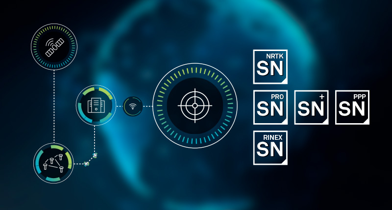
With HxGN SmartNet, Hexagon has built a reliable, scalable GNSS infrastructure that integrates physical reference stations, specialized software such as Leica Spider, and a secure environment for distributing precise positioning data. Supporting tens of thousands of users worldwide, SmartNet delivers the accuracy and continuity essential for daily operations across many sectors.
The MMoU signatories hope to advance resilient positioning services and strengthen geospatial capabilities for nations around the world. Through joint initiatives, they aim to:
Enhance continuity and accuracy of GNSS-based positioning services
Strengthen resilience against signal interference
Support countries in developing and maintaining geodetic infrastructure
Expand education and workforce development in geodesy.
These initiatives ultimately help end users access more consistent accuracy, higher service availability, and stronger resilience against jamming or spoofing.
The MMoU was signed by Henning Sandfort, president, Geosystems Business Area, Hexagon, and Dieter Fritsch, Hexagon’s representative to the UN-GGIM Private Sector Network, on Nov. 17.
“Joining the MMoU underscores our commitment to ensuring that accurate, dependable geospatial information is accessible to governments and organisations worldwide,” Sandfort said.
“Hexagon’s contribution under the MMoU demonstrates the importance of global collaboration between Member States, UN and the geospatial industry,” said Nicholas Brown, head of Office at the UN-GGCE. “Hexagon is a key player of GNSS technology and digital reality solutions and therefore mostly welcomed to contribute the future vision of a strengthened global geodesy supply chain.
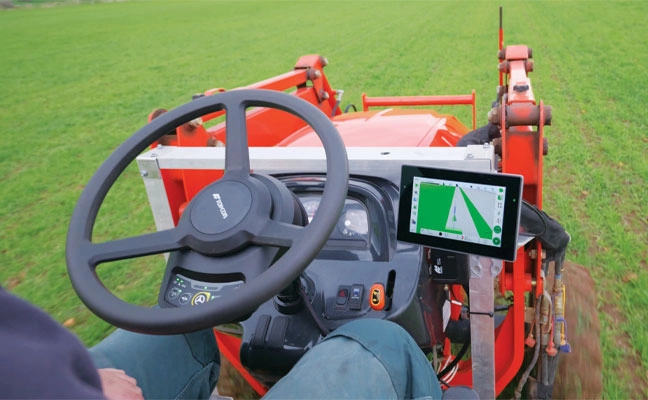
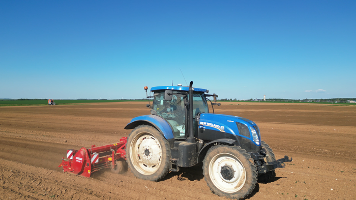
Allows upgrades of older machinery for smaller farms
Topcon’s has created a Value Line Steering solution for farmers using mid-range tractors on small- to medium-sized farms. It makes autosteering technology — typically used on larger machinery — accessible to a broader range of farmers. Farmers with older or smaller machinery, or small specialty farms, can boost the value of their machinery with the autosteering technology. The integrated system is designed to work across a wide range of applications, machinery and brands. It includes compliance with ISOBUS-UT to offer universal compatibility and ease of use. The package includes a GNSS receiver, electric steering wheel controller, touchscreen console and Horizon Lite software, compatible with front-wheel-steer tractors. Farmers can add local, satellite or RTK correction services such as Topcon’s Topnet Live for enhanced precision.
While grapes are being harvested throughout Italy, the Politecnico di Milano is looking to the future of viticulture with an innovative approach that combines mechanics, IT and digital simulation.
A team of researchers from the Departments of Mechanical Engineering and Electronics, Information and Bioengineering at the Politecnico di Milano has developed a system to test and optimize self-driving strategies for agricultural tractors in a virtual environment.
The study, published in AgriEngineering (“Scenario Generation and Autonomous Control for High-Precision Vineyard Operations}, presents a complete methodology for creating realistic vineyard scenarios and evaluating control algorithms for autonomous driving. The goal is not simply to reduce the human presence, but to provide a high-fidelity digital environment in which to develop, verify and safely improve agricultural automation solutions based on sensors and predictive algorithms.
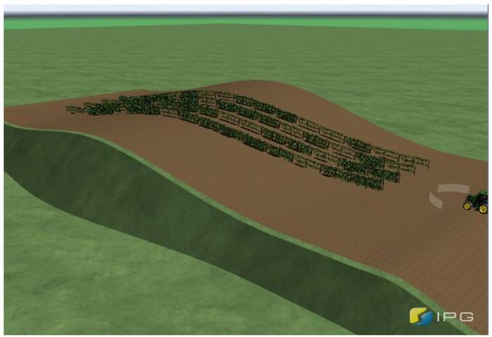
The research has made it possible to create a digital twin of the vineyard, capable of reproducing slopes, soil irregularities and row layout. Tractors equipped with low-cost GNSS and inertial measurement systems (IMS) sensors and guided by advanced algorithms have been tested in this virtual environment, vehicles capable of moving autonomously between rows and of performing off-field turning manoeuvres with the utmost precision.
The study explored new methodologies to simulate and independently control vineyard operations. (Credit: Politecnico di Milano, CC BY-SA).
“Our approach combines terrain modeling, advanced control and realistic sensors in a single simulation environment. This speeds up research and reduces the risks and costs of real field tests,” said Federico Cheli, professor at the Politecnico di Milano, Department of Mechanical Engineering, and project coordinator.
According to the researchers, the use of realistic simulations not only reduces the risks and costs of field tests, but can also become a useful tool for operator training. It can accelerate the adoption of new agricultural technologies.
The project stems from the partnership between researchers at the Politecnico di Milano and the company Soluzioni Ingegneria s.r.l. that develops software for dynamic vehicle simulation. It is part of a broader context of cooperation with industrial companies engaged in research on automation and sustainability in agriculture.
Ruiz Mayo, C.; Cheli, F.; Arrigoni, S.; Paparazzo, F.; Mentasti, S.; Pezzola, M.E. Scenario Generation and Autonomous Control for High-Precision Vineyard Operations. AgriEngineering 2025, 7(2), 46. https://doi.org/10.3390/agriengineering7020046
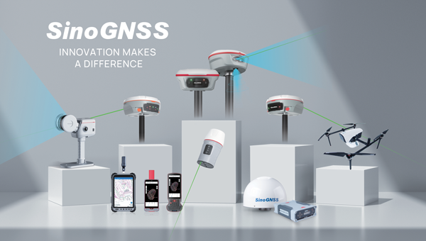
As the geospatial industry accelerates toward automation and intelligence, ComNav Technologies is redefining its role in the market. In this exclusive interview, ComNav leadership discusses the company’s transition in 2025 — evolving from a traditional GNSS hardware provider into a comprehensive solutions and services company that seamlessly integrates positioning, perception and cloud-based intelligence.
As surveying evolves from manual, point-based measurement to automated, cloud-connected ecosystems, ComNav explains how they’re positioning themselves at the forefront of this industry transformation — empowering professionals to shift from repetitive fieldwork to high-value data processing and decision-making.
What would you consider ComNav’s most significant breakthrough in 2025?
Innovation — as our slogan says, “Innovation Makes a Difference.”
In 2025, ComNav has achieved a key transformation from being primarily a GNSS hardware provider to becoming a comprehensive GNSS solution and service company. We are extending our capabilities beyond traditional receivers and boards into CORS network construction, cloud-based GNSS services, and intelligent software platforms.
This transition marks a major step toward integrating hardware, software, and cloud services, allowing us to deliver not only precise positioning equipment but also complete, scalable solutions for global customers. It reflects our long-term commitment to driving innovation and shaping the future of intelligent navigation.
What key improvements has your technology recently achieved?
ComNav has made significant progress in multi-sensor fusion and core GNSS technology.
We have advanced our real-time multi-sensor fusion technology, integrating GNSS, lidar, camera and IMU to deliver higher reliability and spatial awareness in complex environments. This innovation enables a shift from point-based measurements to full 3D spatial mapping, opening new possibilities for surveying, autonomous systems, and digital twin applications.
ComNav’s real-time multi-sensor fusion technology, integrates GNSS, lidar, camera and IMU to deliver higher reliability and spatial awareness in complex environments.
How is ComNav planning to advance its multi-frequency, multi-constellation GNSS technology in 2025? Which constellations are you now supporting?
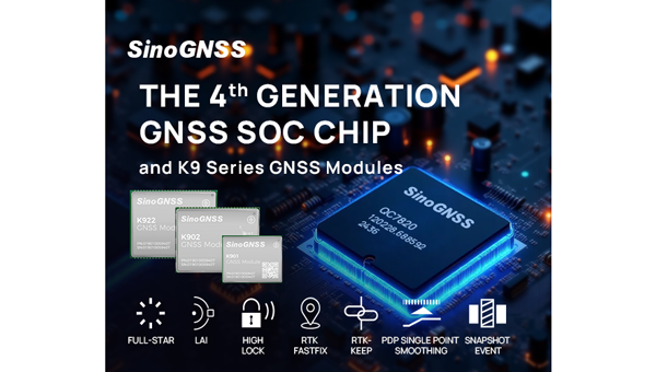
We proudly launched the fourth generation of our high-precision GNSS SoC chip, which integrates full-constellation, muti-frequency RF and BB into a single compact design. This chip offers higher positioning accuracy, lower power consumption, and improved anti-interference performance — setting a new benchmark for GNSS receiver technology.
It employs multi-constellation simultaneous equation technology, ground-based and satellite-based augmentation technologies, SBAS technology, RAIM technology to deliver highly reliable position and attitude information to users. The chip supports various positioning modes, including RTK, RTD, PPP, PDP, SPP, and GNSS + INS, making it suitable for a wide range of complex high-precision positioning scenarios.
Which industry sectors saw the most growth for ComNav solutions in 2025 – agriculture, construction, surveying, autonomous vehicles, or others? Are there any successful use cases you can share from these sectors?
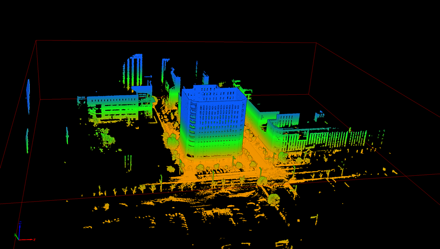
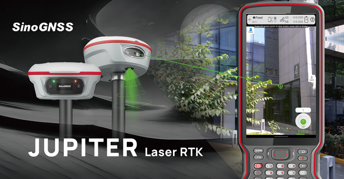
ComNav’s Jupiter GNSS receiver integrates a 50 m laser, IMUm and camera technology.
In 2025, geospatial remained the fastest-growing for ComNav.
Driving this growth is our newly launched Jupiter GNSS receiver, which integrates a 50-meter laser, IMU, and camera technology. This combination enables non-contact measurement, greatly enhancing operational efficiency.
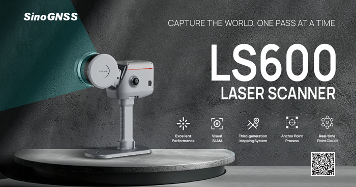
Our newly released LS600 laser scanner further expands this innovation. It combines advanced SLAM technology, a built-in RTK module for centimeter-level accuracy, and dual wide-angle cameras for vivid color capture. The LS600 significantly simplifies field workflows and allows users to easily obtain high-quality 3D point clouds, transforming traditional “single-point measurement” into multi-dimensional, intelligent data acquisition. This represents a major leap forward in efficiency, safety, and precision for complex surveying operations.
The LS600 seeks to significantly simplify field workflows. It allows users to easily obtain high-quality 3D point clouds, transforming traditional “single-point measurement” into multi-dimensional, intelligent data acquisition.
At the same time, our agricultural segment has also achieved remarkable growth. The AG501 Pro supports a wide range of guide line designs and delivers operational accuracy of up to 2.5 cm. Continuous software updates and optimization have further improved user experience, making precision agriculture simpler and more efficient. It embodies our commitment to empowering smarter, more sustainable agricultural operations through GNSS innovation.
Are there any new product lines we can expect to see launched next year?
In 2026, ComNav will introduce a new generation of integrated lidar and RTK products, combining high-precision GNSS positioning with advanced laser scanning technology. This integration will enable professionals to capture both geometric and spatial data simultaneously, delivering faster, more comprehensive field data collection.
We are also preparing to release an upgraded handheld laser RTK, designed for maximum portability and ease of use. With enhanced measurement accuracy, longer range, and improved connectivity, it will empower surveyors to perform rapid, precise measurements in a wide range of field environments.
These new product lines reflect ComNav’s ongoing commitment to expanding its technology ecosystem — integrating positioning, perception, and intelligence into one cohesive solution.
How do you see the industry evolving over the next year, and how is comNav positioning itself to stay ahead to market changes and challenges?
We believe the geospatial industry is entering a new stage of intelligence and automation. The traditional boundary between field data collection and office data processing is rapidly disappearing. Surveying is evolving from manual, point-based measurement toward automated, intelligent, and cloud-connected workflows — where data captured in the field is seamlessly processed, analyzed, and visualized in the cloud.
To stay ahead of this transformation, ComNav is focusing on intelligent integration — combining high-precision GNSS with sensors, AI algorithms, and cloud platforms. Our goal is to enable surveyors to shift their efforts from repetitive fieldwork to high-value, intelligent data processing and decision-making in the office.
By investing in smart software, real-time cloud services, and integrated hardware platforms, ComNav is positioning itself as a key driver in building the next generation of intelligent geospatial ecosystems.
The AG501 Pro supports a wide range of guide line designs and can deliver operational accuracy of up to 2.5 cm.
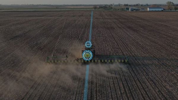
Ag Leader has launched RightPath, a passive implement steering solution, to alleviate issues in precision agriculture resulting from drift.
Putting the right seed in the right location with the right fertilizer is critical for farmers, and has led to the wide adoption of technology such as autosteer. However, if the pass-to-pass accuracy isn’t perfect at planting, the crop is vulnerable to damage in subsequent passes, which drags down yield.
Trailed implements are known for drifting off the guidance line even when farmers use autosteer. The result is inaccurate placement of inputs and inconsistent guess rows. This is an issue because accuracy drives yield.
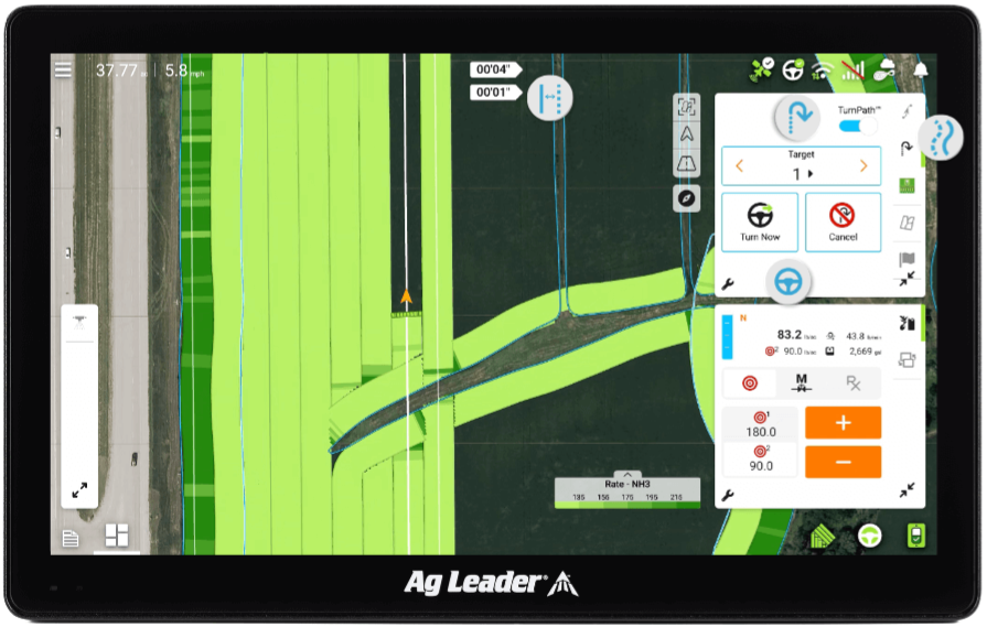
RightPath is designed to operate seamlessly through Ag Leader’s InCommand Go displays. (Image: Ag Leader)
A passive implement steering solution, RightPath keeps implements centered on the guidance line. This not only ensures precise input placement but also increases operational efficiency throughout the growing season, while minimizing crop damage, yield loss, and operator challenges.
RightPath enables farmers to:
place the implement — and therefore rows and inputs — in the right place.
plant seed accurately relative to a previous operation such as strip-till or NH3.
achieve consistent guess rows in all conditions including curves and uneven terrain.
re-use the same guidance line in the next field activity.
reduce stress and fatigue.
RightPath is designed to operate seamlessly through Ag Leader’s InCommand Go displays. In addition, RightPath is compatible with both SteerCommand Z2 and SteadySteer, Ag Leader’s integrated and assisted steering solutions.
While both the vehicle and implement require Ag Leader’s GPS 7500 to utilize RightPath, only the vehicle needs to be equipped with TerraStar-C, TerraStar-L or RTK. This gives an operator the flexibility to choose the right GPS correction for different operational needs.
RightPath is available now through a single purchase unlock, with no recurring subscription fee.
BDStar Navigation subsidiary TruePoint has introduced the TruePoint.CM network real-time kinematic (NRTK) service across Europe, the latest in BDStar’s expansion into international high-precision positioning markets.
Supporting all major GNSS and QZSS, the service is designed to improve signal reliability in complex European environments. TruePoint.CM is built on the company’s chip-cloud integration architecture and works with both BDStar’s Unicore and third-party GNSS hardware through standards-based interfaces.
The service provides wide-area coverage throughout Europe, the company said, offering centimeter-level accuracy with fast convergence times. Before launch, TruePoint conducted extensive validation testing in more than 40 cities across 12 European countries, including more than 300,000 kilometres of dynamic field trials.
The platform uses an adaptive data protocol to reduce bandwidth consumption by up to 70% while maintaining full positioning accuracy, a feature aimed at helping customers reduce operational data costs. Remote diagnostics and over-the-air firmware updates are incorporated to support more efficient device management in the field.
TruePoint.CM operates on a fully redundant cloud infrastructure spanning data sources, data centers and service-delivery interfaces. The system is designed to ensure continuous uptime, backed by a stated service availability of 99.9%.
At launch, the company reported that it has already secured commercial adoption in the European robotic lawn mower market, with additional opportunities expected in autonomous robotics, UAVs, precision agriculture, automotive and consumer IoT.
Trimble has launched its data collector portfolio. The suite includes the Trimble TSC710 data collector, the Trimble TSC510 controller and the Trimble T110 tablet, built for advanced functionality and integration across field operations.
When used with Trimble Connect, a common data environment and collaboration platform, or Trimble WorksManager civil site management cloud software, users can exchange data between the office and jobsite in near real-time to improve operations.
As the physical interface between Trimble hardware and software, the data collectors translate the physical world into an accurate digital representation and back. They enable connected workflows through Trimble Connect and Trimble WorksManager, giving users real-time access to a single source of truth for all project data. Combined with Trimble field software, users can unlock productivity and efficiency gains with quality control capabilities that help reduce project errors and downtime.
The devices are part of an integrated technology ecosystem of Trimble hardware and software, enabling a single source of truth for all project data. The approach enhances collaboration for professionals in surveying and mapping, construction, utilities, mining, oil and gas and public safety and forensics.
“Trimble is dedicated to pushing the boundaries of what’s possible in the field,” said Boris Skopljak, vice president of geospatial at Trimble. “This new data collector portfolio empowers our customers with the tools they need to be productive and stay connected in any environment.”
The portfolio includes:
Trimble TSC710 data collector — Ideal for working with large model data files on a construction site, the TSC710 features a 7-inch touchscreen, a full keyboard and a Qualcomm processor that is faster and uses less battery power than the TSC7. The TSC710 runs on a Google Mobile Services-certified Android 14 operating system. Built for maximizing productivity around connected workflows, the TSC710 is equipped with 5G WWAN support and all-day battery life. The TSC710 has a narrowed neck and is 150 grams lighter than its predecessor.
Trimble TSC510 controller — Engineered to boost field efficiency and optimize workflows, the TSC510 is a robust handheld device with an IP68 rating, compared with IP65 for the TSC5, that enables continuous operation with an all-day battery and a Qualcomm processor up to three times faster than the TSC5, with twice the memory and storage. The TSC510 features a 5-inch screen and runs Android 14. With updated WWAN and Bluetooth modules, teams stay connected for smooth data exchange and real-time project updates.
Trimble T110 tablet — The T110 maximizes field productivity with an Intel 14th-generation Core Ultra 7 processor, built to handle demanding projects and large datasets, including point clouds and imagery. Its rugged design ensures reliable performance in demanding environments. The T110 combines features of the Trimble T10x and Trimble T100 into a single field tablet, including a powerful processor, swappable batteries, 4G LTE WWAN and a Trimble Empower bay enabling communication with Trimble field devices.
Availability
The Trimble data collector portfolio is available now through Trimble’s global network of dealers.
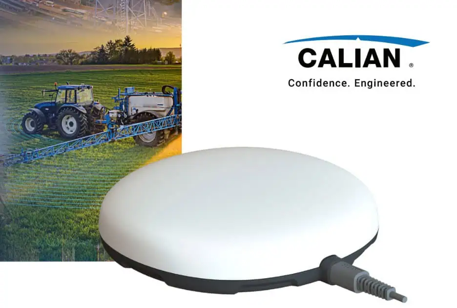
Calian GNSS, a leader in high-precision antenna technology, has introduced the Accutenna 4 (AC4) antenna family for increased accuracy, reliability and performance across the full GNSS spectrum.
Based on a novel stacked composite patch antenna element, the AC4 element combines a robust and compact, full band quad-feed design, in half the weight of current patch antennas on the market. Its highly efficient radiating element and precise phase pattern associated with Calian’s proven eXtended Filtering (XF) technology will deliver clean and accurate signals, even in today’s crowded RF environment.
Whether it’s surveying, autonomous systems, precision agriculture or defense, the AC4 ensures users can rely on GNSS data when it matters most.
Designed with precision applications in mind:
Full GNSS band coverage. Supports GPS, Galileo, BeiDou, GLONASS, SBAS and correction services in one antenna, making it a versatile, future-proof solution.
Accutenna 4 technology. Four-feed compact stacked composite patch antenna minimizes multipath interference and keeps the phase centre stable, ensuring centimetre-level accuracy.
Lightweight, rugged options. Available as embedded (85 g) and in multiple mounting styles for diverse applications, from embedded systems to demanding field use.
Noise rejection. Integrated Extended Filtering (XF) technology blocks interference from new LTE and other signals that can disrupt GNSS performance.
With the Accutenna 4, Calian GNSS expands its portfolio, reinforcing its role as a partner for organizations that depend on precision GNSS antenna innovation.
Allows upgrades of older machinery for small farms
Topcon’s has created a Value Line Steering solution for farmers using mid-range tractors on small- to medium-sized farms. It makes autosteering technology — typically used on larger machinery — accessible to a broader range of farmers. Farmers with older or smaller machinery, or small specialty farms, can boost the value of their machinery with the autosteering technology. The integrated system is designed to work across a wide range of applications, machinery and brands. It includes compliance with ISOBUS-UT to offer universal compatibility and ease of use. The package includes a GNSS receiver, electric steering wheel controller, touchscreen console and Horizon Lite software, compatible with front-wheel-steer tractors. Farmers can add local, satellite or RTK correction services such as Topcon’s Topnet Live for enhanced precision. Topcon, topconpositioning.com
U-blox has expanded its partnership with Nordian to deliver its PointPerfect Flex (PPP-RTK) centimeter-level correction services across Argentina and Paraguay, building on existing coverage in Brazil as part of a broader regional expansion strategy.
The PointPerfect Flex GNSS correction service addresses growing demand from South America’s agriculture sector, while also serving drone operators, surveying and mapping professionals. The expanded coverage delivers centimeter-level accuracy at scale without requiring deployment of additional local base station infrastructure, enabling agricultural solution providers to implement precision automation solutions across remote areas where traditional RTK networks are not economically viable.
PointPerfect and u-blox GNSS receivers are developed in close conjunction with each other to achieve optimum results. The system supports both SPARTN data format optimized for u-blox receivers and RTCM format for non-u-blox GNSS RTK receivers, ensuring broad compatibility.
JAVAD GNSS, a global provider of high-precision GNSS solutions, and Inertial Labs, a VIAVI Solutions Company, have entered a strategic partnership to integrate Inertial Labs’ IMU-P modules with JAVAD’s advanced OEM GNSS receivers. This collaboration introduces a new GNSS+INS platform designed to deliver accuracy, stability and resilience, even in environments where GNSS signals are weak or unavailable.
Central to this advancement is the JAVAD TR-3Si receiver, engineered for compatibility with professional IMU modules. Combined with the advanced IMU-P units, the system is positioned to offer high levels of precision and reliability, supporting mission-critical requirements in aerospace, defense, autonomous vehicles, UAVs, robotics, precision agriculture and other demanding sectors.
Inertial Labs’ IMU-P modules can perform in dynamic settings, providing continuous orientation and acceleration data for sensor fusion. The integration of this inertial technology with JAVAD’s established GNSS systems enhances navigation accuracy and efficiency in both GNSS-accessible and GNSS-denied environments.
JAVAD GNSS is expanding its support for IMU modules and is expected to release further updates on this initiative.
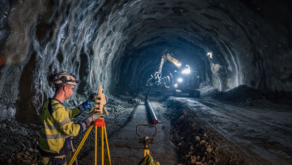
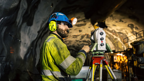
Hexagon’s surveying solutions are playing a key role in the construction of Project Rogfast, a 27-km subsea road tunnel in Norway that is set to be the longest and deepest of its kind. Running 392 m below sea level, the tunnel will link Stavanger, Haugesund and Bergen, aiming to cut travel time by up to 50% and strengthening economic connections in the oil and gas sector.
The project, led by construction firm Skanska, presents unique engineering challenges, including tunneling from both ends with a final meeting point that allows for no more than a 5 cm margin of error. Even small misalignments could result in significant delays and costly rework. Skanska is using Hexagon’s portfolio of Leica Geosystems solutions to align machinery and validate measurements in real time, enabling precise tunneling under extreme conditions.
Hexagon’s technologies are delivering measurable impact across the project by:
Enabling precise alignment with total stations, GPS, multistations and laser scanners.
Reducing rework, emissions, and cost through real-time data capture and validation.
Powering safe operations under extreme conditions, 392 m below sea level.
“In a project like this, even a millimeter of misalignment can trigger cascading risks,” said Trond Valleur, vice president at Skanska. “Hexagon’s technology gives our teams the confidence to move forward with accuracy, efficiency and safety.”
The Leica Nova MS60 MultiStation is a robotic total station that can measure points down to 1 mm to 2 mm and capture 3D scans. (Credit: Hexagon)
The collaboration reflects a partnership between Skanska and Hexagon that has spanned more than 30 years. The Skanska team is using several Leica Geosystems surveying instruments, including the Leica RTC360, Leica MS60 MultiStation, Leica AP20 AutoPole and Leica TS60.