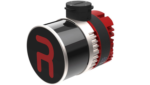
YellowScan and Argosdyne have partnered to integrate YellowScan’s Surveyor Ultra OEM lidar system with Argosdyne’s newly C2 Class certified AQUILA-2 UAV. This collaboration aims to improve data acquisition and drone performance for various industries.
The C2 Class certification allows for safer operations near people and in urban areas, meeting European safety standards. Combined with YellowScan’s lidar technology, this certification allows for more precise and efficient data collection for surveying, mapping and environmental monitoring projects.
The integrated system captures detailed point cloud data and high-resolution imaging, providing comprehensive views of topography, structures, and vegetation. This technology can be applied in urban planning, construction, infrastructure inspection, and environmental science. Argosdyne’s AQUILA-2 UAV was showcased at INTERGEO 2024.
This is a challenging time for coral reefs. Although they cover less than 0.1% of the ocean floor, coral reefs support 25% of all marine creatures. Collectively, they form one of the planet’s most important ecosystems. Their health is in jeopardy due to increased ocean acidification, rising temperatures, pollution runoff, and overfishing and other destructive fishing practices.
The news is not uniformly bleak. A global study of coral reefs that seemed wildly ambitious when it launched in 2014 suggests that some coral reefs are showing impressive resilience. Some could even be considered thriving.
From the beginning, managing the study, dubbed the 100 Island Challenge, has depended on a creative and geographic approach.
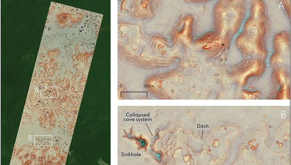
Geographic information system (GIS) technology helped the 100 Island Challenge scientists define the initial scope of the study. Now it is allowing them to visualize and analyze the data they collect. GIS has also enabled the construction of environmental digital twins. In this case, the highly realistic and navigable 3D models depict many of the world’s major coral reefs, capturing flora and fauna in precise detail.
Reassessing Reefs
“I’m focused on coral reefs because it’s a great place to watch animals,” said Stuart Sandin, an ecology professor at Scripps Institution of Oceanography at UC San Diego. “Organisms are packed together, interacting with one another.”
Since the early 2010s, marine ecologists like Sandin have noted how reef health is indicative of a greater overall breakdown in ocean health.
“The timely issue was that we were seeing a ton of degradation,” he said. “It was no longer just a discussion about these ecological principles.” Coral health became a matter of global urgency that highlighted a possible tipping point, with coral decline contributing to biodiversity loss.
Sandin was drawn to the question of local and direct human influences, like overfishing and pollution. He realized that this was, at its roots, a spatial question and it was urgent. If humans were causing harm, changes could be made to reduce the impact. Analyzing the connection involved assessing the influence of humans on nearby reefs.
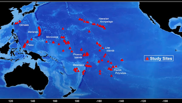
One of the earliest inquiries Sandin and his Scripps colleagues made involved the Line Islands, 11 atolls in the central Pacific Ocean, a thousand miles south of Hawaii. The mix of inhabited and uninhabited atolls belong to the Republic of Kiribati (pronounced “KIR-ee-bas”) and US territories.
Studies of the coral reefs near the uninhabited islands yielded positive results.
“The baseline ecosystems were everything we dreamt of,” Sandin said. “Tons of big sharks, big corals, clean water. We thought it was cool that those conditions still exist.”
When Sandin’s team turned to some of the Kiribati islands with small but growing human populations, the difference was stark. Human activity—particularly the modest amount of fishing done by residents of this small country—had degraded and even destroyed some of the reefs.
The results appeared to speak for themselves. Islands with no human presence had healthy reefs—those with people did not.
As Sandin looked at other islands around the world—including other more distant Kiribati islands—he discovered the strict dichotomy did not hold true. Some inhabited islands that had experienced many generations of fishing still had thriving coral ecosystems. The health of an island’s reef systems was not necessarily determined by human presence.
“I realized the human dimension was more than just binary,” Sandin said. “It wasn’t just presence versus absence. I knew we should start studying the variation of human use, where it works well and where it doesn’t.”
The selection of regions and islands within regions is strategic, with an aim to capture the variability of environmental conditions. (Photo: courtesy of the 100 Island Challenge team at Scripps Institution of Oceanography)
The Challenge Begins
A major challenge of studying ecosystems, even those as spatially concentrated as a coral reef, is the dizzying array of factors that affect their function. Sandin’s team defined 18 types of islands, based on such factors as the size of the human presence and the island’s geography.
The team members decided they should find five island examples of each of the 18 classifications, meaning the project was committed to studying 90 islands. Then they decided that adding 10 islands, bringing the total to 100, would give the study a more impressive pedigree. “We rounded up to make the T-shirts look better,” Sandin joked.
From the beginning, the 100 Island Challenge presented logistic hurdles. Sandin’s team had to research islands for possible inclusion, classify them, and maintain a globally dispersed atlas of candidates. The islands chosen are mostly concentrated throughout the Pacific, the Indian Ocean, and the Caribbean Sea. The team has attempted, whenever possible, to work with residents on each island to both ensure respect for its culture and maximize local knowledge.
“Every island has a story,” Sandin said. “And that’s why we had to go bigger.”
Mapping the Challenge
GIS maps played a key part of building the massive atlas, giving the team members an ongoing reference as they gathered data. The team aimed to visit each island in the study at least twice to monitor changes over time.
GIS also provided a way to determine specific observation sites for every island. From each of these vantage points, researchers can visualize key spatial relationships, including the location of reefs and human settlements, the size and extent of fishing industries, and freshwater sources that flow into the ocean.
The maps promote transparency. Shared with people who live on the inhabited islands, GIS maps help everyone understand the study’s objective of measuring ecological health.
The maps also support the data-gathering process, which includes both low- and high-tech components. Divers swim the reefs, making observations that fall in various categories, such as coral conditions and the amount of wildlife. These categories become individual data layers on the map.
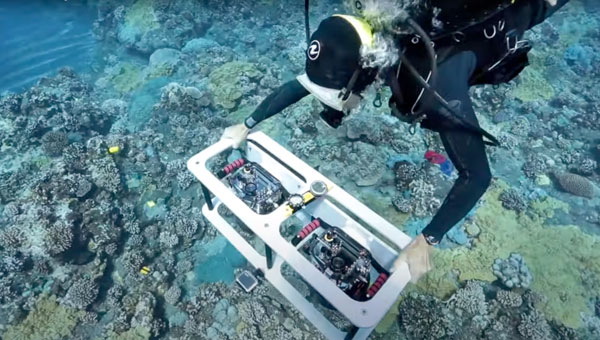
Divers carry still cameras that record one geotagged image every second. This amounts to millions of images added to the map, documenting the conditions of reefs for further study.
A dual-camera rig captures high-resolution images that can be stitched into a 3D composite for ongoing analysis of each reef. (Photo: courtesy of the 100 Island Challenge team at Scripps Institution of Oceanography)
Coral Fights Back
“One of the first things we observed, with the help of image-based mapping products, is that the idea that every coral on the planet is suffering is a complete fallacy,” Sandin said. “What’s actually happening is that every coral on the planet is growing. But in patches, we’re seeing a lot of them die.”
The situation may not be universally dire, Sandin added, but it is urgent.
“Every coral we see is fighting,” he said. “They’re getting hit, site by site, by different stressors, like pollution and overfishing, and some of the hot-water events they can’t recover from. But there is resilience.”
The data-gathering cameras serve a dual purpose. They document reefs that have not been able to recover from the stressors, particularly those linked to climate change. At the same time, the cameras serve to document the resilience. Both objectives help researchers understand how coral can thrive under modern conditions.
Underwater Digital Twins
The amount of data collected by the 100 Island Challenge is staggering. And it’s all feeding into the digital twin.
“Right now, we’re actively involved in finding a way to deal with this petabyte of data, making it transparent and accessible,” Sandin said. “That’s where a lot of these spatial analytic tools and all the creative approaches to visualize data really come into play.”
Thanks to advances in data processing and GIS-enabled imaging, millions of images can be processed quickly. Aided by game engines, computers can stitch together realistic 3D digital twins of the reefs.
Scientists and GIS novices alike can, in effect, explore the reefs in stunning detail. The resolution, which approaches millimeter level, is high enough to see baby coral. The digital twins have also helped scientists understand the dispersal of adolescent and adult coral. GIS tools can even measure the buffering zones around different coral types in various stages of development to see how they interact with each other.
Granting a Voice
For those whose lives are deeply entwined with the reefs, the study’s GIS maps show the coral’s struggle to save itself.
“One of the stories that really struck me was when we were meeting with one of the governors of the southern states in Palau,” Sandin said. “We showed him printed maps and he said, ‘I’m a fisherman, and the fish talk to me. They can tell me what’s wrong. If there are too few fish, I go somewhere else. But the reef has never had a voice.’”
As Sandin recalled, the governor pointed to the map. “This,” he said, “gives the reef a voice.”
Sodex Innovations, an Austrian company specializing in construction surveying technologies, has unveiled the SDX-4DVision and SDX-Compact machine-mounted terrain mapping systems.
These systems integrate advanced sensor technology and artificial intelligence (AI) driven data processing to create digital twins of worksites while the machine operates. Data is uploaded to the SDX Cloud, allowing for real-time analysis from any location. This allows professionals to monitor evolving site conditions, track inventory through automated volume calculations, and make remote data-driven decisions.
The systems are designed for easy installation on various types of heavy machinery, such as wheel loaders and dozers, making them ideal for construction, mining and civil engineering projects. Their adaptability enables efficient data collection and site monitoring, making them accessible not only to professional surveyors but also to operators and team members who are involved in daily operations.
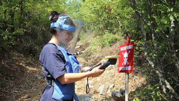
Trimble has expanded support for The HALO Trust, the world’s largest humanitarian landmine-clearance nonprofit organization. Trimble is donating an additional 175 Trimble Catalyst GNSS systems, including Trimble DA2 GNSS receivers, to help The HALO Trust further its demining operations worldwide.
Building on the impact of the ongoing collaboration, Trimble’s latest donation will support the expansion and productivity of The HALO Trust’s mine clearance teams. The Catalyst GNSS system provides The HALO Trust with a solution for deploying precise mapping capabilities to large field teams across broad geographic areas. More field teams can now be equipped with the necessary tools to safely and efficiently clear landmines, thereby accelerating the pace of landmine clearance globally.
Since receiving Trimble’s product donations and the Trimble Foundation Fund-directed grant, The HALO Trust has made significant progress in landmine and unexploded ordnance (UXO) clearance. From January to September 2024 alone, The HALO Trust cleared 802 minefields and battlefields, covering a total area of 10,400 acres across 12 war-torn countries. During this period, 31,209 landmines and other Explosive Remnants of War (ERW) were safely destroyed — all accurately mapped using the Trimble Catalyst GNSS system. The HALO Trust’s use of Trimble technology has significantly improved operational efficiency and provided essential data for safe land reclamation and development. According to The HALO Trust, the accuracy and reliability of Trimble’s technology have been crucial in ensuring the safety and success of demining operations in areas severely affected by conflict, such as Ukraine, Angola and Sri Lanka.
Inertial Labs has introduced the RESEPI Ultra LITE, a lightweight payload combining lidar and camera technology for advanced surveying and mapping applications. The system integrates the XT-32 lidar scanner to offer users advanced data accuracy and point density across various operational modes.
The RESEPI Ultra LITE has a compact design with a 5MP colorization camera, making it ideal for small unmanned aerial systems (SUAS) with strict volume constraints. It can be used for aerial and ground-based applications, including utility mapping, construction volumetrics, precision agriculture, forestry, site surveying and mining.
Designed for seamless integration, the system is compatible with a wide range of platforms such as Freefly, WISPR, DJI, Sony and mobile setups. Inertial Labs’ proprietary SnapFit adapters ensure quick and secure mounting to enhance the system’s adaptability.
A graduate student analyzing publicly available drone data in Mexico unexpectedly unveiled a vast ancient Mayan city hidden beneath a dense jungle in Campeche on the Gulf of Mexico. The findings, published in the academic journal Antiquity, reveal an extensive urban complex covering an area approximately one-and-a-half times the size of Washington, D.C.
Luke Auld-Thomas, a Ph.D. candidate at Tulane University, stumbled upon this while browsing the internet, according to NBC News. The data, originally collected by a research group studying land-use patterns, was captured using UAV mapping technology and lidar. Auld-Thomas applied archaeological analysis methods to the survey data, leading to the identification of the ancient city.
Unraveling the mystery
The research team named the newly discovered city “Valeriana” after a nearby freshwater lagoon. This urban center consists of 6,674 structures, including pyramids reminiscent of those found at Chichén Itzá in Yucatan and Tikal in Guatemala. Valeriana likely housed between 30,000 and 50,000 inhabitants at its peak.
Researchers believe Valeriana flourished during the Classic Maya period (AD 250 to 900) and likely collapsed between 800 A.D. and 1,000 A.D. The city’s decline is attributed to a complex set of factors, with climate change playing a significant role. Marcello Canuto, an anthropology professor at Tulane University, explained that climate variability caused stresses and adaptations, leading to systemic unrest in densely populated areas.
Valeriana’s discovery highlights how surveys and lidar can be used in archaeological research. This newly adopted method uses laser pulses to penetrate forest canopies and capture detailed images of hidden landscapes. Canuto describes it as a form of “digital deforestation,” allowing researchers to uncover extensive, previously unseen layers of history in remote and inaccessible regions.
GPS World Editor-in-Chief Matteo Luccio sat down with Anthony McClaren, product marketing manager of geospatial technologies at Trimble, to discuss Trimble’s new R980 GNSS receiver and its implications for the geospatial surveying industry.
What’s your position?
I am on the Trimble Geospatial Go to Market team. Product marketing managers are more customer-facing, while product managers are more engineering-facing. I’m based in Melbourne, Victoria, Australia, and I’ve worked at Trimble for almost two years, but I worked with Trimble equipment for 16 years before that for a dealership and for almost 20 years in the geospatial surveying industry. The rest of my team is based in our Westminster head office.
What’s new about Trimble’s R980? What markets does it target?
The Trimble R980 takes over from the R12i GNSS system as the flagship product in the Trimble GNSS receiver portfolio. New features include a communications update. The R12i had only a 450 MHz radio. The R980 also has a 900 MHz radio. That’s very beneficial for people who find themselves on large-scale construction sites where they use 900 MHz radios, particularly in North America. These radios are much easier to license than 450 MHz radios, which outweighs the disadvantage of having a shorter range.
The R980 can be used as either a base station or a rover, correct?
Yes. The R12i had a 3.5G modem. The R980 has a 4G LTE cellular modem. So, it’s a global cell modem and the 4G network across the globe is far more expansive than 3G or 5G. 4G LTE also offers enough data downloading for things like VRS and Trimble’s Internet Base Station Service (IBSS), a new feature in Trimble Access software that the R980 is also capable of using. IBSS is a user’s Network Transport of RTCM via Internet Protocol (NTRIP).
So, you have a base station with a SIM card in the receiver. You start your base station as normal, and data is streamed to a Trimble data center. Then, you take your Rover, as we do today with a VRS survey. It has a SIM card, either in the receiver or in the controller, and you can connect directly to your base station via the Internet and stream your own corrections.
It is particularly useful if you’re not in a VRS environment or if you want to get the range of using a cellular network instead of radio. It also means that you don’t have to consider where you’re going to put your repeater, such as on the top of a hill. You don’t have to worry about these sorts of things anymore, because we’re using the Internet to stream out corrections rather than a radio.
You’re also uploading data to the office in real time.
That’s handled separately, via Trimble Connect on your data collector. It’s transferring data directly to a project.
This is your top-of-the-line, survey-grade receiver, right?
Absolutely.
In terms of cost and other considerations, for what other applications is it practical?
We’re seeing a lot of our topline receivers being used in civil construction, transportation, infrastructure projects, and mining — because the Trimble receivers are tracking all the currently available satellite signals. It means that surveyors working in an open-cut mine can be at the bottom of the pit and still achieve survey-grade results because they’re tracking so many satellites. It is also used by the more traditional, everyday land surveyors who are out there walking the streets, because the R980 with Trimble ProPoint GNSS technology allows our users to measure in the most rugged GNSS environments, such as urban canyons.
Speaking of walking down the street, the R980 is for either static deployment or slow-moving platforms, not for vehicles, right?
Correct. The mobile mappers that we see on vehicles have very high-end inertial measurement units (IMUs) to provide heading, pitch and roll and use lidar or laser scanning to take the measurements. The R980 has an IMU to enable very accurate tilt compensation up to at least 30°.
Looking at the broader trends in the industry, how do you see requirements changing? Of course, it depends on the market…
One thing that doesn’t depend on the market — I have learned this since joining Trimble — is that globally a lot of the industry is facing the same issue, which is a massive shortage of surveyors to meet the demand for them. In Australia alone, I think we’re short about 2,400 surveyors for next year. So, it’s quite a significant number. Our customers on the ground are being asked to do a lot more with a lot less.
So, Trimble’s goal with our products — whether it’s our top-of-the-line GNSS, total stations or something more entry level — is giving our customers the most productive equipment that we can so that they can do their jobs as quickly and efficiently as possible. That’s why we have such things as Trimble Connect.
So, it’s not just about single point measurement anymore. It’s about using the ecosystem to be as efficient as possible. Once I’ve taken a measurement, what am I going to do with it? Beyond that, it’s in my data collector, which is using Trimble Connect to sync to the office, where I have Trimble Business Center software. So, the surveyors and the draftspeople at the office can start work on that straightaway and keep the guy in the field working.
Concern keeps growing about spoofing and jamming, mostly for defense and life-critical applications. How do you see that affecting some of your civilian markets?
Currently, in civilian applications, most of the jamming that we’re seeing is ad hoc and unintentional, not nefarious. For example, a truck driver who uses a consumer-grade jammer plugged into his 12-volt outlet so that his boss can’t track him. It’s unpredictable. I’ve also seen banks transmitting their data back to the head office near an antenna for a CORS site and jamming it.
Trimble receivers have anti-spoofing and anti-jamming solutions. They deal with spoofing in a multi-layered way. Number one is rejection of spoof signals in the digital signal processing. Essentially, that means that a spoofed signal generally comes through with a higher correlation peak, because the transmitter is probably closer than a satellite 20,000 km away, so the receiver can isolate that signal and reject it from the positioning algorithm. Also, when it comes to spoofing and jamming, it tends to be a particular constellation and not a particular satellite. So, if you’re experiencing jamming or spoofing generally, it’s going to be all the GPS or Galileo constellation — not, say, satellite 32.
Our survey-grade receivers use the Maxwell 7 technology, which can also cross-check orbital data from multiple sources. So, it’s detecting the orbital parameters transmitted by each satellite, and it can then check if any of those have changed unexpectedly, or if they fall outside of reasonable bounds, and exclude them.
Are you utilizing any non-GNSS PNT sources, such as signals from LEO satellites?
Not today. Is there a place for them in the future? Absolutely. Is Trimble aware of such things as Xona low-Earth orbit (LEO) satellites? Yes. Obviously, we would love to be using those, when they’re ready and when we have products ready.
What about AI?
AI is an interesting one. That’s obviously a hot topic, isn’t it? Today, we don’t necessarily use AI. When it comes to such products as the R980, we use mixed reality — where you have data overlaid by the camera in your controller and using your receiver and turning around, you can see your digital environment as well as your physical environment — but we are not using AI as such today. We overlay CAD data on what is physical, and it’s still three-dimensional. So, regardless of whether I turn this way or that, I can see my design in the real world.
Leica Geosystems, part of Hexagon, has released upgrades for its BLK2FLY autonomous flying laser scanner. The scanner captures building exteriors, interiors, structures and environments to create 3D point clouds while flying autonomously.
The Leica BLK2FLY is a semi-autonomous flying laser scanner ideal for architects, engineers and designers to capture the exterior features and dimensions of buildings and environments that would otherwise require a UAV with a lidar payload or a traditional photogrammetry UAV. To operate the BLK2FLY, a user makes a few simple taps on a tablet and the BLK2FLY captures a structure’s complete external dimensions, such as rooftops and facades, in the form of colorized 3D point clouds.
The BLK2FLY also features new scanning and two new indoor and outdoor scanning workflows. It also offers three different levels of scan quality based on environment and user needs. These levels include:
• Standard Quality: Ideal for large outdoor environments requiring the least amount of time. • High Quality: Suitable for complex outdoor or larger indoor environments. • Very High Quality: Useful in narrow and complex indoor environments.
Do you remember the free-standing car navigation devices that were popular for a while, such as those made by Garmin and Magellan? Few people use them anymore because to find our way when driving, most of us use our smartphones instead.
Smartphones now have a plethora of sensors, including inclinometers, accelerometers, magnetometers, barometers and light sensors. However, cost and size constraints (the insides of those small devices are so crowded!) limit the accuracy of smartphones’ GNSS receivers.
Therefore, to accomplish professional mapping tasks, it is now increasingly common to pair a smartphone — which provides computing power, a display, motion sensors, a camera and Internet connectivity — with an external GNSS receiver and antenna.
This and other changes in the industry make product categories long in use obsolete or, at least, less compelling. What is a mobile GNSS solution? Are the terms “mapping grade” and “resource grade” still useful? Who is using which devices for which tasks?
I discussed these issues with Bernhard Richter, VP Geomatics at Leica Geosystems, which is part of Hexagon, and with Igor Vereninov, CEO of Emlid.
— Matteo Luccio, Editor-in-Chief
Leica Geosystems: Conversation with Bernhard Richter, VP Geomatics at Leica Geosystems, part of Hexagon
We used to divide GNSS receivers into consumer grade, resource grade (for GIS data collection) and survey grade.
Those lines don’t exist anymore to the same extent. Some of the lower-cost chipsets — which were originally built for mobile phones and Garmin devices and lower-accuracy stuff — can now provide higher accuracy. We call them industrial-grade chipsets. The need for UAVs, e-scooters, e-bikes, automotive applications, etc., triggered their development. They are coming closer to the premium boards — let’s call them the multi-frequency, multi-constellation receivers that were always built for real-time kinematic (RTK)-type applications.
So, it’s the bottom that’s coming up.
There is still a need for single frequency code-only chips on the one hand for the mass market and, on the other hand, for premium devices from companies such as NovAtel (part of Hexagon), Trimble, Hemisphere and Septentrio. There is a new tier, which we call industrial grade, from companies such as u-blox and Unicore, which come a bit closer to the premium segment.
I’ve always thought of location-based services (LBS) as using consumers’ locations to connect them with retail and services. People use their smartphones to find the nearest coffeeshop, but what has not happened is coffeeshops saying, “Hey, I see that you are within 500 feet of our store. You should come in, because we’ll give you a discount.”
In our field, we make money by providing decimeter- or centimeter-level solutions to our users for surveying, machine control, GIS, etc. When it comes to needing locations for other applications, such as retail, everything is already nicely integrated in smartphones, and consumers just utilize what is there.
In order to get a better precision than the one provided by the cellphone, you need a small, extra GNSS device connected to the cell. Then, instead of using the position provided by the phone, the application will use that much better position. That trend will go on for quite a while. This is the change to what was standard in the last decade, when we built dedicated handheld controllers with fairly high-cost chipsets to enable GIS applications. These GIS devices seem to be disappearing. It’s either an Android or iOS-based phone or tablet, and now you add a hockey puck-type GNSS antenna. Then, you override or mock the position that is coming from the internal chipset on the phone, and the app uses that more precise position. That is the new standard for GIS, so to speak.
Analogously, for a decade we had dedicated car navigation devices. They disappeared because our phones now do that.
Exactly. Where we can really add is in providing that extra bit — not only hardware, but also software and services. Decades ago, we developed the HxGN SmartNet RTK service. Now, we also have HxGN SmartNetGlobal, which is both a terrestrial-based service and augmented by a satellite-based precise point positioning (PPP)-type service. Simple car navigation devices such as those by Garmin or dedicated GIS controllers have almost vanished. It’s always a smartphone or a tablet plus, if a centimeter-level solution is needed, an additional device.
It does not make a lot of sense to fully integrate high-precision GNSS into these mobile devices, because the customer group who really needs a centimeter-type solution is too small, and it would put an extra burden on the engineering for the tablet or the smartphone. Nobody complains if you attach a device that weighs a few hundred grams. I also think that you shouldn’t integrate things that don’t belong together. The different components have different life cycles. A smartphone today is old when it’s 18 months old, right? But, with the volume that’s sold to customers needing high precision, we cannot renew the equipment every year.
Are you talking about a smart antenna?
Today, a GNSS chipset can be as small as a two-Euro coin. However, if you want to do high-precision GNSS, you still need a decent-sized antenna. So, you cannot go to a fingernail size with the antenna element. If you need a good amount of multi-pass mitigation in the analogue way, you need a beer coaster-sized ground plane. Now, typically, you also put in a MEMS-based inertial measurement unit (IMU), so that you do more than just the pure GNSS position — pitch, roll and yaw are important as well.
Phones already have IMUs.
It’s always a matter of what you want. Do you want five meters or one meter or sub-decimeter repeatable at high reliability? Then you need to add more, higher-value components, right? Also, if you just take what’s in an iPhone, it’s not so easy to calibrate those MEMS. Engineers could probably solve the problem, but precision is never the primary goal for a smartphone and would increase complexity.
In addition, in an iPhone, you don’t really worry about aging of the components or whether they can survive a fall from 1.5 m. So, we look at the application and the environment in which the customers are using it, then we select the best components to really add value to, let’s say, the existing iPhone’s position.
In September, we released a high-grade antenna about the size of an ice hockey puck with a very small and tightly integrated GNSS chipset and inertial measurement unit (IMU). Then, of course, we have our own processor to run our positioning engine. It brings in all the corrections that we can provide with our SmartNet service. So, we provide a centimeter solution and pitch, roll and yaw in the most compact form.
Then the phone becomes just the interface.
Yeah, the phone position gets mocked by the position, for example, from a FLX100 plus, and the app takes the better position.
The app is the user’s interface with the puck.
Yes, but the survey device — the “GNSS puck” together with the phone running the app — is only one element of what a typical GIS user needs. Most important are the data themselves and the cloud system that hosts them. The data are the key enablers. If you think of Esri, for example, their value is hosting the data, having the geospatial relationship between the data and enabling decision-making.
The geospatial acquisition part became really easy and can even be done in a tilt-compensated way, so you don’t even need to level your survey pole. The surveyed points are typically automatically synchronized or uploaded to the cloud system. So, if you say that the phone is just the user interface, I kind of disagree.
A utility technician using the Leica GS05 GNSS receiver for the surveying and utility industries, which Leica released in September. (Photo: Leica Geosystems)
You’re collecting data and feeding them to the cloud, but they are also on the device to display.
The data themselves are only stored inside the app or in the cloud and can be displayed. The GNSS device itself keeps streaming the position but nothing gets stored there.
How much do you collaborate with ESRI, in terms of their application and the data?
Jack Dangermond [Esri’s co-founder and president] once said, “portal to portal is key these days.” At Hexagon, we have our applications, our industries and our focus areas, and ESRI has its. To me, the way to be successful is to have systems that are compatible and portals that can talk to each other. So, to me, portal to portal is and will be key.
You mean the portals in the cloud?
Yes, they have an API interface and they can talk to each other. I’ll give you one concrete example. We have a product called the FLX100. It is a little puck, has a helix antenna, a receiver engine, but does not have a cellular phone integrated. We’re using the cellular connection of the user’s mobile phone. So, you connect the mobile phone to the FLX100.
We have software called Zeno Mobile One that has an Esri interface. So, we can immediately synchronize everything we measure with ArcGIS Online and ArcEnterprise. This is how we developed our GIS asset collection software. We need an accurate position, of course, which we provide through the hardware that we sell with the FLX100 plus. It can also connect to any RTK service — but, ideally, we connect to our own SmartNet service. As soon as we collect an asset — such as a pipe, a fire hydrant or a manhole — the operator annotates it, “This is a manhole, this is a gas pipe, this is a water pipe,” whatever. Then, the data can be uploaded immediately, already in the right file structure, e.g. into an Esri environment.
We can also run an Esri product, such as ArcGIS Field Maps, on the smartphone and still talk to our hardware. This is very interchangeable these days. If you’re not doing this, I think you limit yourself too much when it comes to data collection. We understand the whole workflow much better than in the past and can be open to certain services, such as Web Map Service (WMS) or Web Feature Services (WFS). You can download the map of your town, then download, let’s say, the entire public water system and load it into this map. Then you can make changes, add new pipes, etc. So, there are many services that enable you to add to an existing map.
So, you’re using Esri’s APIs like anybody else.
Theoretically, you’re right; we use those published interfaces. However, we are Esri Gold Partners, so we really work with Esri to make this happen. There are also open-source products, such as QGIS.
What do you mean by “industrial-grade” receivers?
UAVs doing high precision photogrammetry are one of the biggest market for RTK positioning. However, the highest-end boards from the likes of NovAtel (part of Hexagon) and Trimble are less often used in these applications nowadays. So, UAV manufacturers and operators switched to smaller, lower-cost chipsets. This is one area where this field developed. We are talking about hundreds of thousands of UAVs. So, it became a significant market.
Also, today lawn mowers do not just follow random patterns on lawns. They start integrating those more high-precision chipsets. These days, they are more and more multi-frequency, multi-constellation.
Who’s using something like the puck that you were describing earlier? It’s neither average consumers nor surveyors.
It’s a very good question. We still need to differentiate between the high-precision geodetic market or the scientific market where highest reliability is needed and the GIS market where reliability is of lesser priority. In many cases, such as high multipath, foliage coverage and jamming — there are typically no anti-jamming tools on these lower-cost chipsets — there is a strong need for highest end GNSS cards and a significant difference. Nevertheless, the GIS market is still of significant market size.
Every fiberoptic cable that’s being put underground these days in countries such as Germany, Austria and Italy must be mapped on the open trench. It would be quite costly for those companies who put the fiber optic cables into the ground to call a surveyor each time. So, they train their own technicians to do the job and need many handheld units. We have customers who need 100 crews equipped with the same GNSS equipment. That is the kind of customer group that needs this mid-tier of products.
There are other markets for the mid-tier products, such as photogrammetry, which is coming back because of the improvements in digital cameras and the power of the processors in the field, and then everything with augmented reality. This customer group still needs some control points or RTK positions, but they typically don’t want to spend too much on highest precision equipment.
What is new about the FLX100 plus?
We integrate it into the world of mobile devices in a new way. It is a change from an integrated handheld controller to something that’s separated from the tablet or the smartphone. From an accuracy point of view — if we’re not talking about very challenging cases such as heavy foliage or multipath and 50 km baselines — the FLX100 plus is really good. I think we are at the level where we were with the highest-grade GNSS equipment in 2005 or 2010.
At GPS World, we have used the term “mobile solutions” for a long time but, as the technology changes, it’s hard to use the same categories.
The mid-tier and high-end premium will increasingly blur. So, there isn’t such a clear line anymore. The distinction will disappear, not the equipment itself, for those who want the highest reliability — such as surveyors, who typically earn their living by putting their stamp on a map or a plan and are liable for errors. These customers want the best possible also under very difficult conditions.
Emlid: Conversation with Igor Vereninov, CEO at Emlid
What does Emlid do? How large is it? Where is it based?
We build high-precision RTK receivers and software for them. We are based in Budapest, Hungary, and we also have development offices in Belgrade, Serbia, as well as in Lisbon, Portugal. We are more than 100 people now. We are a diverse bunch, developing everything inhouse — including electronics, embedded software, mobile applications, cloud services and beautifully designed enclosures.
Why did you start the company?
I started the company with my co-founder out of my kitchen, 10 years ago. We started with the idea of making RTK more affordable. Back then, survey gear was very complicated, required a lot of training and was super expensive. We were maybe a bit arrogant, being just out of university, and we thought, “Yeah, we should definitely try to disrupt that.” We built super-affordable receivers, completely crowdfunded on Indiegogo, without any outside capital. Our personal money was very limited, so all the money we had in the company came from our future users.
At that time, our receiver was just a board, but from there we saw so much interest and the orders started to flow. We realized, “Okay, this is going to be big, so we better build a fully recognized and waterproof device that surveyors can use in the field and is not just for DIY hackers and geeks.” That’s how it started.
What came next?
We first had the Reach receiver, which was the board, then the Reach RS, the Reach RS+, the Reach RS2 and the Reach RS2+. Now, we have our Reach RS3, which is super-popular worldwide. We’re now widely known, and our receivers are still very affordable, robust, easy to use and as accurate as any other receiver out there.
To me, the term “mobile solutions” refers mostly to data collection for GIS, but these categories are very subjective. What are the key trends you see in the industry?
A big industry trend is that more and more people inside companies are interacting with centimeter accuracy and with RTK. Previously, it was only surveyors, but now we are seeing that an increasing number of people in the field will have access to accuracy. We play a large part in this story because we democratized RTK and brought it to other professionals outside of surveying.
Traditionally, we had RTK accuracy at one end of the spectrum, a GPS receiver inside your iPad or iPhone at the other end of the spectrum, and in between sub-meter devices, which traditionally occupied the GIS space. Now, customers and potential customers tell me that the sub-meter category is becoming less and less present and attractive. As the RTK technology becomes super accessible and affordable, all the consumers from the sub-meter space are shifting toward centimeter accuracy. Maybe they don’t really need it in the field, but they feel like …
They might as well have it!
Yes, why not just have it, right? It’s the same cost, so why not equip our field crews with centimeter accuracy? We now have easily accessible and affordable, or even free, correction networks. The devices themselves now cost less than $2,000 and are easy to use.
That’s the kind of conversation we are having regularly with customers and potential customers. They’re saying, “Why not have it?” They want to upgrade the accuracy of their mobile mapping device — typically, an iPad. It’s not enough to be able to tell, for example, on which side of the pipeline the valve or junction box is. They really would be fine with 10 or 20 cm of accuracy, but then why not go to that 1 cm level?
Another trend is using iPhones and high-precision GPS for site documentation. We now have deployments of hundreds of units in the field using a combination of an RTK GPS receiver with lidar and camera sensors inside consumer-grade devices, such as iPads or iPhone Pros, to document such things as accidents and construction progress — especially for large infrastructure projects, such as fiberoptic networks.
Your Reach RX, for example, is an external device that talks to a tablet, right?
Yes. We’re seeing the use of our receivers in combination with the sensors inside an iPhone to document objects with very high accuracy and with absolutely no training by the person doing the job. You really don’t need a trained person to do it. For example, an excavator operator — who is not typically doing any kind of mapping but is a professional in a different space — would be able to grab an iPhone with an external RTK receiver and map things with centimeter accuracy for reporting purposes.
I find it very exciting that we’re able to use this mix of consumer-grade technology with RTK that is rapidly becoming very affordable. Together, they give us a platform that allows us to document things super-efficiently and bring it into the hands of more professionals. We are seeing more and more startups in that space as well.
All your receivers are GNSS receivers, correct?
Yes, everything that we make is all-constellation and multi-frequency GNSS.
A surveyor using an Emlid mobile RTK network rover, a Reach RX, in an urban environment. (Photo: Emlid)
What are the main end-user applications for your devices?
We sell a lot to land surveyors and to drone pilots. Many drone pilots are increasingly becoming surveyors, and many surveyors are increasingly becoming drone pilots. So, those two groups of people are moving toward each other, and we are happy to serve both. Our devices are very popular and are the standard for drone workflows. This is a big market for us. Also, construction and mobile scanning.
What about utility companies mapping their assets?
Yes, we work with businesses that need to manage some kind of infrastructure or a large collection of assets. Water companies are very big users. They have many undocumented areas and a lot of people working in the field. For them, it’s crucial to have an affordable system that they can put in the hands of untrained people. Also, fiber optic networks, gas pipelines and agricultural companies have similar demands.
Today, a traditional RTK GNSS receiver costs at least $20,000. Our Reach RX is $2,000; our Reach RS3 with tilt compensation is $3,000. This completely changes the game. So, we are opening this field for professionals, for architects, for landscape designers, for agricultural applications. We’re seeing archeologists use it. These guys would have never bought a system for $20,000 or $30,000. Now that it’s $2,000 or $3,000, it’s a different story.
What do you make specifically for GIS?
We recently introduced the Reach RX MFI, which is certified for use with Apple devices. This Reach RX integrates natively with Esri’s ArcGIS Field Maps, the most common platform for GIS data collection workflows. It required certain hardware modifications to connect to iPhones natively and some integration work with Esri. It is another way in which our Reach RX receiver can be used. Every one of our Reach RX is now a Reach RX MFI.
Tell me about the Pix4D.
We have a kit that consists of two parts. The hardware part is our Reach RX centimeter-grade, survey RTK receiver. The software part is the PIX4Dcatch mobile app on an iPhone Pro or Pro Max, which has a lidar sensor and a very good camera. As a part of the kit, you receive a bracket to mount everything together, forming a unique system that is easy to use, accurate and affordable. It uses the lidar for scanning.
And the sensors in the phone to determine its attitude …
Yes, and the huge photogrammetry experience that Pix4D has. They’re using their full photogrammetry engine to process the pictures, along with the lidar from the iPhone and highly accurate GNSS, which allows them to stitch together essentially survey-grade models just using this simple set of equipment.
I’m very excited about this technology being so accessible and easy to use.
On Sept. 10, the GeoGov 2024 Summit hosted a panel discussion between NGS and other federal and industry leaders on the modernized National Spatial Reference System (NSRS). High-level management and leadership officials attended the conference, which was a great place to network and collaborate with federal agencies.
Panel session on NSRS modernization.
As you can see from the announcement, the panel members represented a wide range of users of the NSRS. They were asked to address the following four topics based on their perspective of the rollout of the new, modernized National Spatial Reference System:
Benefits of Modernization
Challenges of Modernization
Opportunities Provided by Modernization
Next Steps in Collaboration
As one would expect, there was a wide range of responses based on the individual panel’s perspective of what the new, modernized NSRS means to their products, services and constituents. Even though there were many responses based on the individual panel’s perspective, there were many common ideas. This newsletter will highlight some of the bullet points presented by the panel members during their presentations. I attempted to combine similar statements for every topic under a common theme.
Summary of Benefits of Modernization
A unified four-dimensional system will finally provide a sustainable spatial reference frame for managing the state’s geospatial resources.
Combining of horizontal and vertical datums in one system
Improved spatial data quality – both horizontal and vertical
Simplification in which vertical reference frame and GEOID to use in local areas with the new NAPGD2022
Improved accuracy of the horizontal and vertical coordinates
A common “language” or framework for spatial data
Greater consistency in non-CONUS areas like AK, Hawaii, PR, and USVI
We can write NSRS requirements into any task order for acquisition
Additional uniformity for surveying practitioners
Better spatial data sustainability
The unification of marine and terrestrial geoids is important for managing our valuable coastal resources (all heights should be geoid based)
Closer integration with tidal datum information
Improved height information will enable us to provide the most accurate data possible
Direct relationship to ITRF2020 offers the ability to deliver the intra-frame deformation model through real-time networks
The introduction of reference epochs on NGS geodetic survey benchmarks and the time-dependency of the datums
The ability to more easily link the data to ITRF
Expansion of low distortion projection (LDP) systems
Lack of metadata within historical information to adapt to the new datum
Ensuring data fidelity, now and always! (METADATA)
People and processes; not technology
Users with lack of understanding of a time-dependent datum
Surveyor making time to learn about new datum
Understanding the impact of the new system to your products and services
How do we convince them to effectively transition all their historic data to the latest reference system?
Confusion among end users in understanding geodetic terminology and time-dependent way of perceiving coordinates
Adequate understanding by all stakeholders
Degrading coordinates and heights can impact reliability over project lifespans (NGS may not be able to respond to natural changes and emergencies)
Maintaining an accurate deformation model for use by many geospatial users in their specific workflows
Updating specifications on ground surveys for lidar and ortho projects that are processed through OPUS (How do we better educate our team and partners on what can be considered accurate for those observations)
Updating of existing surveying equipment to include new datum
Potential confusion in reported accuracy as it relates to changes in epoch vs. actual error of the equipment (ground-based or aerial/satellite) and the approach used to measure the feature
Transformations to new datums may incur costs if partners do not want to “modernize” data (Potential of needing two copies of data delivered)
Will need to develop policy deciding if we “modernize” all our older/existing data, or just start with the new NSRS at a certain point in time
Need operational software that reprojects/transforms data – especially large, bulk features (e.g., lidar point clouds)
Combining legacy data with modern data can lead to loss of data fidelity and often difficult to recognize changes to the data
Many challenges were mentioned, but I found it interesting that panel members highlighted issues with the user’s lack of understanding of the new system’s impact on their products and services. It is about people, not the processes or new technology. This was not surprising to me because this was an issue when NGS implemented the North American Vertical Datum of 1988 (NAVD 88). I know this firsthand because I was the NAVD 88 Program Manager while working for NGS. Surveyors and mappers are used to dealing with new technology and datum changes. Still, management and leadership have different issues that need to be addressed for new technology and datum changes. Hopefully, the management and leadership that attended the GeoGov 2024 Summit will start identifying how their products and services will be affected by the new NSRS and developing implementation plans.
Summary of Opportunities Provided by Modernization
Increased collaboration between private entitles and public agencies
Providing better service
Reducing cost
Improving safety and welfare
Expanding innovation
More reliable data for monitoring trends in infrastructure
Providing efficient and cost-effective tools and processes for users to update their mapping products to the new reference system
More accurate data collection/dissemination to benefit the public
More uniformity of data collection between surveyors
Improved reliability of advanced positioning built on the new NSRS
Improved heights for flood mapping products for forecasting, infrastructure planning and design, and accessibility using GNSS
Facilitates integration of tidal datum, critical to coastal science and industry
Allows for unification with SAR imagery and satellite altimetry, improving earth observations and mapping products
Improved Change Detection estimations
Better metadata descriptions for understanding times of collections
Increased vertical data for monitoring existing conditions
More accurate representation of the Earth’s surface over time as it lates to coastal change (sea level rise, flood modeling, coastal erosion, etc.)
Compensating for workforce attrition
As in any new paradigm, there are opportunities for increased collaboration between users and the development of new products and services. The panel members highlighted opportunities to provide better service to customers, develop more efficient and cost-effective tools for users and improve coastal change detection models.
Next Steps in Collaboration
Cross promotion of new datums within likeminded professions
Recruitment into geospatial professions
Increased awareness of the importance of the geospatial professions
New or expanded collaborations across professions
Leveraging non-federal resources and their active user communities spanning surveying, geophysical science, regional governmental agencies, industry, and academics
Working together to convince state/local agencies to adopt the new datums
Working with geospatial societies (NSPS, AAGS, ASPRS, URISA,etc.) for impact awareness
Working together to identify the new NSRS impact on your products and services
Guidance from professional organizations and societies
Implementation of tools and processes for datum conversion for large remotely-sense datasets for more effective data analysis for reporting climate change
Under the next steps in the collaboration section, promoting the new reference frames with other geospatial professionals was mentioned as an opportunity to leverage resources and expand the understanding of the new NSRS’s effect on users’ products and services. That is, increasing the number and types of stakeholders and constituents affected by the new reference frames will increase awareness of the new NSRS.
Joint Actions to Promote a Smooth Transition
Promoting awareness to non-technical leadership within AEC industries
Provide examples of the potential for a datum upgrade (smart cities, digital twins, autonomous transportation.)Educate allied professionals (e.g. engineers, contractors, operators.)Develop unified messaging for practitioners (e.g., best practices/standards.)
Focus on the education component and benefits of the new datum.
Act now to develop a specific plan and resource allocation to implement the new reference frame
Helping develop appropriate standard metadata/STAC templates and information
Provide open-source tools to the private sector to enable datum conversion and an open discussion forum.
For a smooth transition of the new NSRS, it is important to identify actions required for implementation. Promoting awareness to leadership is critical for the implementation of any new system. In the case of the new NSRS, it is essential for federal agencies to get engaged in the process now. I was pleased to hear that panel members mentioned that it is vital for federal agency engagement through the Federal Geographic Data Committee (FGDC) and the Federal Geodetic Control Subcommittee (FGCS) to be compliant with the Geospatial Data Act of 2018 (GDA 2018). These federal agencies must develop plans and allocate resources to implement the new NSRS.
As previously stated, high-level management and leadership attend the GeoGov 2024 Summit conference. It is a great place for networking and collaborating within federal agencies and for better understanding the issues associated with implementing the new, modernized NSRS.
Technology and tools are essential for the development of the new, modernized NSRS. That said, understanding how the use of technology and tools meet the users’ requirements is necessary for implementation.
Some users trust NGS models and tools without following the appropriate procedures. Standard operating procedures are used in a workflow to help meet users’ project requirements. In my opinion, understanding the impact of the new system on a specific product and service is the most important part of implementing the new NSRS. Documenting the workflow used to create a product and service and then using this information to develop standard operating procedures that use the appropriate tools and procedures will help implement the new, modernized NSRS.
In less than a year, NGS will be finalizing the new terrestrial reference frames and geopotential datum. Time really is running out and users need to obtain a working knowledge of the new, modernized NSRS.
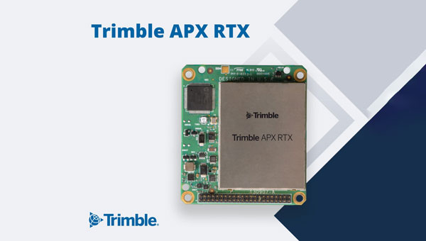
Trimble has introduced the APX RTX portfolio, a new line of direct georeferencing solutions designed for UAV mapping sensors. This system enables high-accuracy mapping across diverse environments, ideal for OEMs and UAV payload integrators.
At the core of the APX RTX portfolio is the Trimble CenterPoint RTX technology, which offers both real-time and post-mission direct georeferencing. This capability allows for centimeter-level accuracy without the need for base stations, making it compatible with various sensors, including cameras, lidar and hyperspectral mapping devices.
The system’s hardware features include a compact GNSS inertial unit that supports real-time positioning. Additionally, external inertial measurement unit (IMU) support is an option to enhance orientation accuracy. The portfolio also utilizes high-accuracy MEMs calibrated with Trimble Applanix SmartCal compensation technology to improve precision.
It is embedded with compact, survey-grade GNSS inertial hardware that delivers real-time positioning and highly accurate roll, pitch and heading measurements. It includes four variants for mapping at different flying heights and beyond visual line of sight (BVLOS), enabled through greater orientation accuracy.
The Trimble Applanix IN-Fusion+ multi-sensor aided inertial technology leverages Trimble ProPoint GNSS technology to offer consistent performance in various environments. The APX RTX portfolio offers the Trimble CenterPoint RTX Complete subscription to streamline workflows. This subscription combines real-time functionality with post-processing capabilities in POSPac UAV, eliminating the need for separate licenses or internet connections.
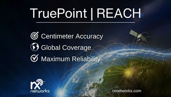
Rx Network has launched TruePoint | REACH, an advanced, hardware-agnostic, cloud-based correction service designed to deliver centimeter-level location accuracy worldwide for various professional applications.
TruePoint | REACH offers precise centimeter-level positioning to enhance GNSS receivers’ performance in applications such as precision agriculture, machine control, mining, marine operations, UAV, GIS and more. The service is compatible with leading commercial off-the-shelf receivers using the RTCM 3.3 SSR and the 3GPP LPP SSR format. The company said key hardware partnerships are in the planning stages and will be announced soon.
TruePoint | REACH eliminates the need for users to set up their own base stations. Users can achieve centimeter-level accuracy by connecting receivers to the cloud while leveraging Rx Networks’ comprehensive global coverage.
Its correction engine is built to provide centimeter-level accuracy worldwide and can achieve sub-3cm precision in under 10 minutes. This makes it suitable for applications that require moderate initialization times for high-precision services.
A test version of TruePoint | REACH is available for those interested in assessing its capabilities. Users can sign up for a complimentary 30-day trial license through the Rx Networks website.